Showing posts with label mountain climbing. Show all posts

Thursday, October 12, 2023

Anna Gorin has got Idaho mountain fever! She's up to 160 Idaho summits and counting ... someone to watch!

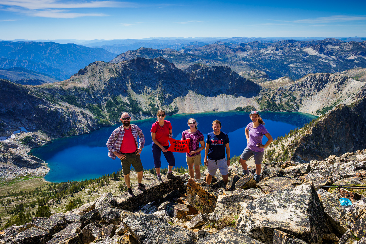
Alpine Peak, Sawtooth Mountains, with Sawtooth Lake below. (all photos by Anna Gorin)

Hi all,

Anna Gorin has Idaho mountain fever. 

A Boise photographer in her young 30s, she pursues big hikes in the Idaho mountains, bagging peaks at a blistering pace. She might climb three mountain peaks in a week, or even a day. She’s scaled 53 mountain peaks so far in 2023, and in 2021, she notched more than 70 Idaho peaks. Overall, she’s notched over 160 high points in Idaho.  

“I love getting out in nature and seeing beautiful views, plus the accomplishment of climbing to the summit,” Gorin says. “I love the alpine scenery, alpine meadows full of glowing wildflowers, and the snow-capped mountains make my heart sing.”

Gorin is on track to join the lists of the most accomplished peak-baggers in Idaho who have climbed more than 300 high points or more. Who knows, at this rate, she might even reach 500.

“Anna not only has a talented photographer’s eye for composition but also a climber’s eye for finding the best lines up mountains, said Tom Lopez, a prolific mountain-climber and author of “Idaho: The Climbing Guide.”   

Galena Peak - what a view! (Courtesy Anna Gorin)

Like me, Lopez has noticed that Anna Gorin is making significant tracks in Idaho's high country. For my outdoor tip of the week, I wanted to introduce Anna Gorin as someone to watch in the outdoor scene, if you haven’t noticed already! I recommend people pay attention to Gorin’s trip posts on the Hiking Idaho Facebook group. I’ve enjoyed reading about her trips and seeing her scale mountains on trails I haven’t experienced before, despite the fact that I’ve spent the last 40 years trying to cover every square inch of Idaho’s backcountry.

Gorin’s energy for exploring Idaho’s mountains is infectious just by the quality of the photos in her posts (she carries a good camera with her on trips), and the raging enthusiasm exhibited by her friends in her summit photos. She’s got a core group of 10-15 friends who go frequently. They’re clearly in great shape and having a great time, but you know that they felt their thighs and lungs burning on the climbs just like any other human being. But they had the gumption and perseverance to reach the summit.

Being goofy on Gunsight Mountain (Courtesy Anna Gorin)

They’ve also got the gusto to bag new peaks as often as possible, putting in late night drives on the bookends of trips to reach the mountains from Boise.

“I like to vary it between McCall, Stanley, Ketchum and Fairfield, depending on the weather. I enjoy going to see new places.”

Just on the spur of the moment, Gorin said her top 5 favorite Idaho peaks are:

  •      Standhope Peak in the Pioneer Mountains (elev 11,878 feet). “The view from the top was epic!” she says.
  •      Johnstone Peak in the Pioneers (elev 9,879 feet). “Sometimes the smaller mountains have better views of the peaks above.”  
  •      Elk Ridge in the Soldier Mountains (elev 8,551 feet). “It’s so pretty up there. That one has a great effort-to-reward ratio."
  •      He Devil in the Seven Devils Range, Hells Canyon (elev 9,400 feet). She saw mountain goats up there.
  •      Kelly Peak in the Sawtooths (elev 9,321).  “That peak has extensive views of the southern part of the Sawtooths.”

Gorin grew up in Boise. She didn’t really experience the outdoors that much as a kid. Her parents home-schooled her; the family went to Stanley maybe once a year. She went to Willamette University for college, majoring in art. She launched a photography business after returning to Boise from college, and she’s been doing that for over 10 years now. She does portraits in outdoor settings for clients and landscape photography. See more at annagorin.com

Anna knows where to find the beauty of Idaho ... Packer John Mountain with her beau, John. 
She also is dabbling with mountain biking. 

How she got into hiking:
In her mid-20s, Gorin started hiking in the Boise foothills, scaling Table Rock, riding the Boise River Greenbelt, things like that. She joined some meet up hiking groups and 20-30 age groups to meet people to go hiking with. A friend convinced her to climb Mt. Borah, Idaho’s tallest mountain, in 2017. She had climbed Mt. Olympus in 2012, which she recalled being quite challenging. It was her first official peak.

After summiting Borah, she was blown away by the roof-top view. “This is an amazing mountain," she thought. "There’s nothing else higher anywhere around me. This is so cool!”

“I loved that feeling, and that drove me to climb more mountains,” Gorin says.

Trip planning: She uses a wide variety of resources in planning her trips, including hard-copy national forest and topo maps, interactive Forest Service map, Caltopo maps online, Google Earth, Tom Lopez’s “Idaho: A Climbing Guide,” Lists of John, and mountain-climbing notes from John Platt, who was a person cut from the same cloth as Anna, but probably more of a technical climber than she wishes to be.

Climbing ridge tops has rewards in terms of big views. But it's hard! 

She also uses AllTrails.com, Summit Post, and more online resources. She spends a lot of time planning trips to understand the challenges ahead; she checks on trail conditions; she checks on weather and snow levels before she goes. She recommends lots of advance planning for a safe journey. But even with all the planning, things can become challenging!

“I also enjoy the puzzle of getting places,” she says. “Sometimes it can almost be like a problem-solving game to figure things out or thrash through the brush while cross-country hiking to find our way to the top.”

Next time you’re online, watch for Gorin’s stunning photography of Idaho’s mountains and trip notes. You might just discover some new places to explore!

-    - SS

Fishhook Point, Sawtooth Range (courtesy Anna Gorin) 


Thursday, November 17, 2016

Try Death Valley as a winter destination to explore unique canyons, dunes and peaks

Mosaic Canyon ... getting into the marble zone 
Red Pass is down where our white pickup truck rental is parked.
On our way to Thimble Peak. 
Thimble Peak 
On the summit. We got out early and beat the heat. 
Titus Canyon 
Hi all,

I took Wendy to Death Valley National Park recently for a quick 4-day getaway, and I was impressed. I'd never been there before. I had heard that it's a great winter destination -- the ideal time to visit a place that has temperatures in the 130s in mid-summer. In early November, we experienced lows in the 60s and highs in the 80s in the afternoons. It's even cooler in December and January.

We stayed at the Furnace Creek Ranch for about $150/night. We liked that spot quite a bit. There's a large swimming pool for ranch guests to use, plus tennis courts and a bacce ball court. Wifi was kind of lame, but you're supposed to be on vacation. There are three restaurants and a general store in Furnace Creek where you can find suitable eats and supplies. There also are many different campgrounds in the national park where you could park an RV or tent camp.

Here are a few places that I'd recommend visiting:

  • Mosaic Canyon - There are some neat rock formations in Mosaic Canyon -- really old limestone rock that dates to 700 million years old is overlain by much more recent compacted sediment and gravel that occurred just several thousand years ago. The old limestone rock eventually changed to dolomite and then marble over the years. About 1 mile up Mosaic Canyon, you get into the smooth marble rock in the canyon walls, and the canyon narrows as you hike upstream. Continue up the canyon, the views and geology keep getting better. 
    Golden Canyon above the valley floor 
  • Golden Canyon - We really liked Golden Canyon. It's close to Furnace Creek, and it's a beautiful hike into Golden Canyon in the morning or evening when the low-elevation light punctuates the topography. The geology in the Golden Canyon area is more fine silt, sand and ash-flow tuff layers from volcanic eruptions. It's a mixture of beige, tan and much older rocks above the silt and tuff layers. You can do an out-and-back hike in Golden Canyon, climb to Zabriskie Point or do a 5-mile loop with a vehicle shuttle. 
    View from Zabriskie Point as the sun was going down 
  • Zabriski Point - This is a super-cool point of interest off the main highway leading into Furnace Creek. It's a very short walk to a gorgeous overlook of the Golden Canyon area. If you go there at sunrise or sunset, the colors are spectacular. We got there near sunset and took a lot of pictures as the sun went down. 
    Loved the twilight from Zabriskie Point 
  • Badwater Salt Flats - Given that this is the lowest point in North America (282 feet below sea level), it's worth visiting Badwater Basin just to say you've been there. It's a salt flat with a trail that goes out into Badwater Basin in the middle of Death Valley. Perfect for a selfie photo. 
    Badwater Salt Flats 
  • Mesquite Flats Sand Dunes - The dunes near Stovepipe Wells Village are quite extensive, a larger dune complex than Bruneau Dunes State Park. We didn't explore the dunes but they looked like fun to explore when the temperatures are moderate. 
  • Titus Canyon - Thanks to some friends, we got a cool tip to go climb Thimble Peak off of Red Pass as part of doing a big driving loop. The canyon is so tight that the whole route is one-way. We drove the Daylight Pass road from Death Valley into Nevada (about 30 minutes), and then drove a dirt road up to Red Pass to start our day hike to Thimble Peak. We climbed up a ridge to a shorter mountain (6,100 feet elevation) and then scaled Thimble Peak (6,500 feet). The 360-degree view was totally spectacular up there. We climbed back to our rental pickup truck, and then drove down Titus Canyon back to Death Valley. You go through an old mining area on the narrow two-track road. Glad we had a high clearance rig! Highly recommend doing that drive and then taking some side-hikes along the way. 
There are many other canyons and peaks to explore in Death Valley. This was just our first trip. But I'd recommend visiting the area in the winter and enjoy a vastly different experience than other canyons and peaks in the West.

FYI - We took a direct flight from Boise to Vegas on Southwest Airlines, rented the pickup truck from Enterprise Rental, and were in Death Valley by around noon. Very easy to get there from Boise, we thought. Many people drive down in their camping rigs so they can camp out and enjoy the area in that fashion. I've heard that when it gets windy down there, camping isn't much fun because of the blowing sand. 
-SS

Wednesday, July 8, 2015

Now that mountain snow has melted, it's time to go backpacking! Try Red Mountain Lakes!

Steve and Quinn on top of Red Mountain 

Huck loves to swim in the lakes 

He likes to help catch fish, too! 

Fish on! 

Here's an Idaho home-grown boy enjoying the wild country ... 
Hi all,

I've been wanting to go backpacking with my son, Quinn, who's 17 and a senior at Boise High this fall, but it's been tough to schedule considering his busy schedule as a student-athlete and worker bee. Finally, last weekend, the stars aligned and we blasted off to backpack into the Red Mountain Lakes with my friend Norm Nelson, who loves to go backpacking anywhere, anytime.

I chose Red Mountain Lakes because it was the 4th of July weekend, and I knew the well-known trails and high mountain lakes in the Sawtooths and White Clouds would be likely over-run with people. And by god, we made the right call! We never saw another human until the 2nd day when we scaled Red Mountain (elev. 8,722') to enjoy the vast views in all directions, and we ran into a nice couple who were on a day-hike to the peak and lakes.
Trip map. It's 3.5 miles one-way and 1,600 feet of climbing
to get into the Red Mountain Lakes. 

In all honesty, I hadn't been to the Red Mountain Lakes for probably 20 years. I remembered that when I had been there before, I had caught fish continuously in one of the lakes. Plus, the area has appeal because it's one of the closest high lakes basins close to Boise. It's maybe a 2-hour drive to the trailhead, northeast of Lowman on the road to Bear Valley. Forest Road 515 takes you right to the trailhead along Clear Creek.

It's a 3.5-mile hike to the first lake. Once you get into the lakes basin, you can fish 4-5 different lakes by Red Mountain, plus, you're super close to the little-known Cat Lakes. Norm swears that he caught two big trout in one of the Cat Lakes, but he failed to take a picture as proof ... I also recommend climbing up to the top of Red Mountain to enjoy the spectacular views of the rooftop of the Boise National Forest

Right now, the wildflowers are peaking on the trail leading to Red Mountain Lakes. We saw an incredible kaleidoscope of colors in the knee-high flowers thriving in the openings below the semi-burned timber ... I could identify red Indian paintbrush, purple lupine, Sego lilies, scarlet gilia, yarrow and yellow daisies. Seems like the elk have an abundance of feed this summer!

Steve enjoying the flowers

Ah the simplicity of backpacking ... After pulling together a week-long trip on the Salmon River with 18 people, 6 rafts and two kayaks in June, it was so nice to get back to the basics of backpacking. All you need are a few clothing items, your sleeping bag, tent, food, backpacking stove, fishing stuff, water, and a water purifyier of some kind. Quinn borrowed a super light pack from a friend that worked great for him. I used my old Kelty XL internal frame pack, but that thing is due to be replaced. Seems like it weighs 5 pounds before you put anything in it!

Norm and I brought fly rods, and I put together a spin cast set up for Quinn. I brought a bunch of Thomas lures for him to try, and he slayed the fish. Thomas lures work great for catching trout in rivers, and I figured they'd do well in the lake. Quinn couldn't get enough of the fishing. He found a hot spot in the lake, and fished it all day long! Wo-hoo!

Now that the snow has melted, there's an endless number of places to go backpacking in Idaho right now. Pore over your maps of the Boise National Forest, Sawtooth National Recreation Area and Payette National Forest and look for high lakes basins. Another good resource is caltopo.com. There are literally hundreds of lakes to choose from. My next trip is going to be in the Pioneers, which are another off-the-beaten-path destination with good fishing and 12,000 spectacular peaks. Maybe you saw my blog about hiking into Betty Lake and Goat Lake last year?

Here's another popular post about three classic bucket-list backpacking trips in Idaho.

If at all possible, take your kids with you. It's super cool to share the wonders of the Idaho backcountry with your kids. They can't help but to be impressed with the beauty of the mountains and the awesome sights of the endless sea of mountains in Central Idaho. Plus, if the fish are biting, they won't want to leave!

Don't forgot your bug stuff ... the mosquitoes were an issue in camp, and the horseflies were out in force as well. Good bug stuff will keep them at bay. Bring lightweight long pants and a long shirt to help protect yourself.

And if you can't get out of town this weekend, go watch the Twilight Criterium in downtown Boise on Saturday. The kids ride with Kristin Armstrong starts at 2 p.m., and a whole slew of races follow throughout the day and evening.  

Have fun!
- SS

Thursday, August 27, 2009

Climb Mt. Borah - it's easiest in late summer

Photos courtesy of SummitPost.com


A friend of mine, Scott Turlington, inspired this week's outdoor tip -- climbing Mt. Borah, Idaho's highest peak (12,662 feet) in the Lost River Range near Arco, Mackay and Challis.

Scott took his 12-year-old son on the adventure last weekend. He said it took them 8 hours to bag the peak, and 6 hours to come back down. There were at least 75 other people on the trail on the day they climbed the peak. His legs were still sore on Wednesday. No wonder ... The typical route involves ascending 5,262 vertical feet (1604 m) from the trailhead to the summit in just over 3.5 miles. Whew, that's steep! The trail grade averages 30 percent.

Experts say it's best to climb Borah in late summer when most of the snow has melted from the summit, and the most technical aspects of the climb can be accomplished without ropes. An ice axe might be handy when you're scrambling across "chicken-out" ridge, a narrow rocky spine with major dropoffs on both sides. Scott said the ridge still had snow on it last week.

Most people drive to the trailhead the night before, make camp, get up about 3:30 a.m., and make the summit before noon. Most people do it as a "day hike."

It's all self-support. Be sure to bring lots of food and water. There is no public water at the trailhead. Even if it's hot to begin with, cold and wet weather can roll in, so be prepared for that.

Here are some links with detailed information about the climb and the mountain:
- Wikipedia
- Peak Bagger.com
- SummitPost.com. This site has driving directions to the trailhead and other useful information.
- YouTube has tons of videos from people who posted their pix and video from the trip. Here are links to a couple that seemed helpful:
- Short clip
- Longer clip: Mt. Borah - the Good, the Bad and the Ugly
- Tips from a woman who's been there

Have fun!