Thursday, October 27, 2022

Try this trio of Boise foothills hikes with fetching, elevated views of the city - nice to see fall colors!

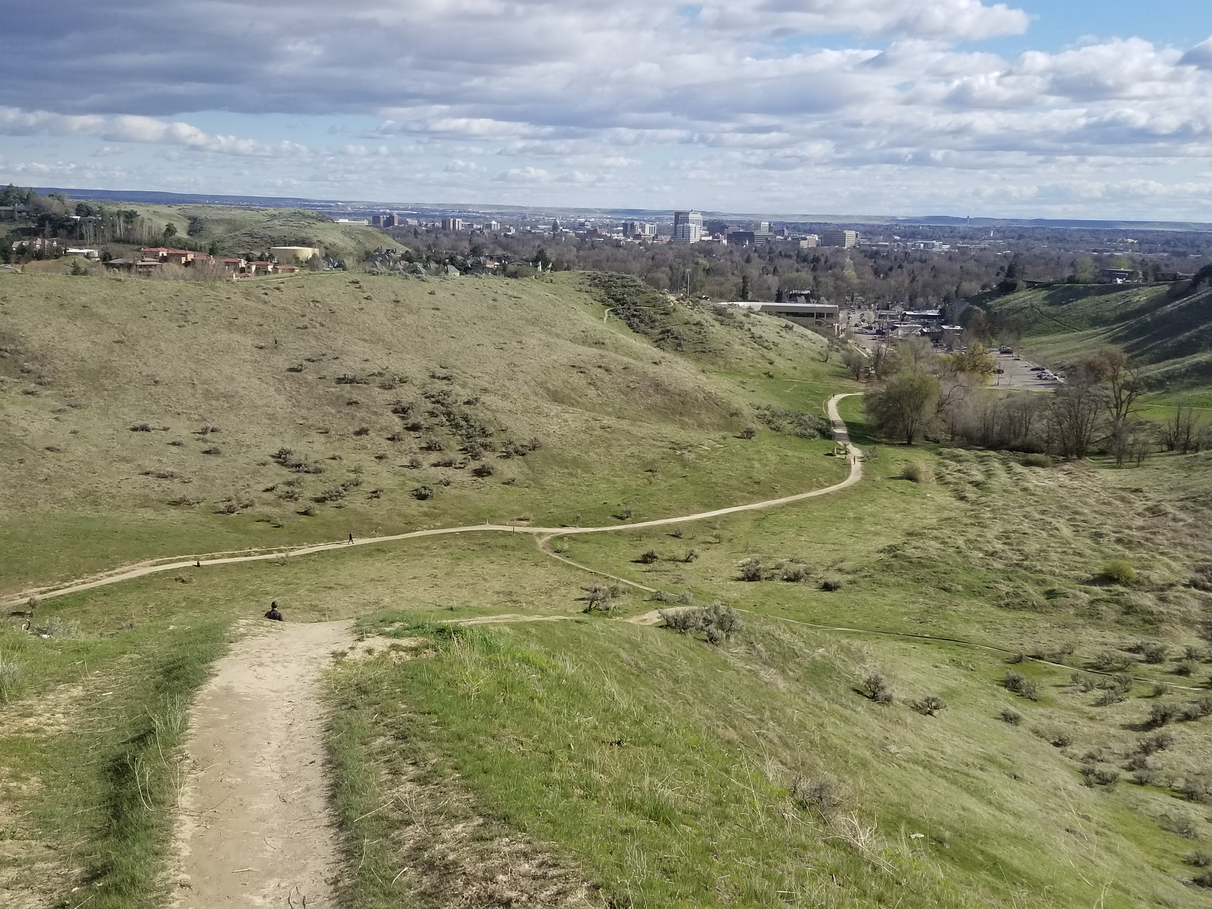
View of Boise from Central Ridge Trail in Military Reserve Park.

Hi all, 

After a nice cool and wet week to turn the page toward fall seasonal norms, the weather this weekend looks quite nice for some weekend outings! Afternoon high temps will be about 57 degrees F and sunny - a bit chilly but you can dress for it.  

Now that the fall colors are beginning to happen in the Boise Valley, for my outdoor tip of the week, I'm recommending three hikes close to home where you can enjoy some fetching views of the City of Trees and the wide variety of colors visible as far as the eye can see! All of these are kid-friendly. 

Full Sail Trail heading over to Buena Vista (courtesy BoiseTrails.com)

Hike #1 - Buena Vista Trail, Hillside to the Hollow.
Difficulty: Moderate. Start either at the Harrison Hollow trailhead by Healthwise or behind Hillside Junior High along Hill Road. Buena Vista Trail has a very nice and moderate contour as it winds across the outer-front of the Boise Foothills, and it feels like you can reach out and touch the community below. Yet, you're at least 500 vertical feet above the city, so it's a great vantage point! If you do an out-and-back walk on Buena Vista, you'd cover several miles over an hour or so. 

Spring shot of Harrison Hollow looking down at the city.

Hike #2 - Central Ridge Trail, Military Reserve Park.
Difficulty: Moderate. Start at the Military Reserve trailhead where Mountain Cove Road bends sharply to the right going west into the foothills. There's a large parking area on the right and a trail map. You can start by walking along the Mountain Cove trail along Freestone Creek for about a mile or so. Then, you can turn to the right and climb up on Central Ridge to that initial summit. Then walk south down the backbone of Central Ridge back toward the trailhead. On Central Ridge Trail, it looks like you're going walk right into the State Capitol building and downtown Boise. Kind of a cool selfie opportunity before you drop down to the trailhead. Travel time for this one would be 1-1.5 hours at a leisurely pace.

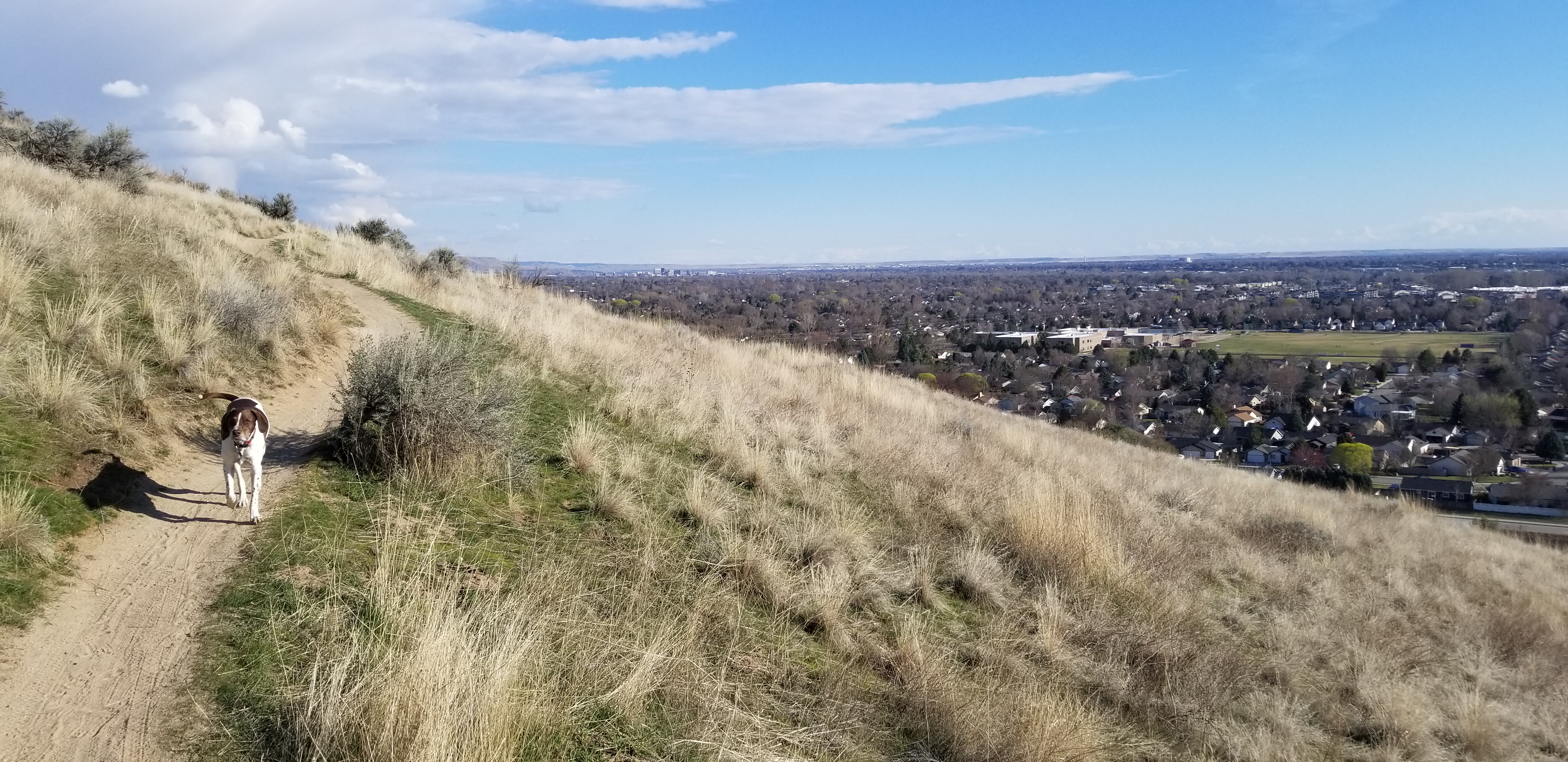
Great views of the city from Valley View Trail 

Hike #3 - Seaman's Gulch Loop.
Difficulty: Moderate. Start at the Seaman's Gulch Trailhead off of Seaman's Gulch Road and Hill Road in West Boise. You have the option of hiking a short loop for 1 mile, or you can hike a longer loop for 3 miles with more views. In my Boise Trail Guide, I called this route "Seaman's Gulch Double Loop." The trails contour nicely across the landscape; you never have to work too hard to climb uphill. 

Short loop: Follow the left-hand fork of Trail #110 and climb to an initial ridge. Bear left at the top on Phlox Trail #112. That'll bring you back to the trailhead. 

Longer loop: Follow the same directions to start with, but once you reach the initial ridge, take Valley View Trail #111 as it wraps around the front of the Boise Foothills, super close to the edge of the city. Once the trail loops around the hills, it ties into Phlox Trail on a ridgetop, and you can head back to the trailhead on Phlox. The longer loop is 3 miles and features 500+ feet of vertical gain. Travel time is 1.5 hours. Take your time and enjoy it! 

All three of these hikes and 92 more are featured in my Boise Trail Guide: 95 Hiking and Running Routes Close to Home. The book is available at stevestuebner.com, Idaho Mountain Touring, Boise REI, and Rediscovered Books. 

Ken and Melissa will be giving away a free copy of Boise Trail Guide on 94.9 FM The River tomorrow (Friday) morning at approximately 7:40 a.m. Tune into my radio gig, and you can call in to win the book at 208-287-2949. 

Have a great weekend! More moisture forecast next week! More snow for the mountains! 
- SS 

Thursday, October 20, 2022

First big winter storm coming this weekend! What will La Nina Triple Dip mean for Idaho ski season?

Fresh *pow* at Brundage Mountain Resort 

Hi all, 

The first big snowstorm of the fall is coming this weekend, and that could put at least the Idaho Mountains into winter mode for the upcoming ski season. Deer and elk hunters also will be rejoicing to see the snow potentially move big game animals down to lower elevations and provide the ability to track their movements in the snow. 

This winter is forecast to be the third La Nina winter in a row or a "Triple Dip La Nina." 

La Nina winter weather pattern map (courtesy NOAA)

What does that mean for Idaho? 

In general, La Nina winters favor more precipitation in the Pacific Northwest and the Northern Rockies. But certainly the last two La Nina winters were not all that impressive, at least in Southern Idaho, the Sun Valley area, and the Upper Snake River watershed around Yellowstone National Park and Jackson Hole, Wyo. 

A late, wet spring saved us after watching the mountain snowpack flatline between mid-January and the end of March. But now, many of Idaho's irrigation reservoirs across the Snake River Plain are close to empty or dry, so we will need a big winter to replenish our water supplies in Southern Idaho. 

How much snowfall is coming this weekend? 

The first burst of the storm system is forecast to bring 10" or more of new snow to Northern Idaho, 4-6 inches in McCall, Tamarack and Stanley, and 1-2 inches at Bogus Basin and Sun Valley through Monday. After a short break in the action, another storm system is forecast next week, bringing potentially even more mountain snow - up to 12" in the West Central Mountains and Stanley area, and 5-7" at Bogus and Sun Valley. Let's hope the forecast holds true! 


What's the Farmer's Almanac say? 

Just for grins, I checked the Farmer's Almanac for predictions on the winter of 2022-23, and their theme nationwide is "Shake, Shiver and Shovel." Ha! They are predicting a strong winter nationwide, and 

The Farmer's Almanac is calling for colder temps and normal precipitation, following the general trend expected from a La Nina winter.

Another indicator that can influence weather patterns was described this week by a meteorologist at Opensnow.com. Alan Smith talked about the Quasi-biennial Oscillation (QBO), which describes trade wind patterns in the tropics. A westerly phase of the QBO is expected to occur this winter, which is a phase that has shown some correlation with above-average winter precipitation across the Western U.S.

Although the sample size is admittedly small, winters that feature a La NiƱa combined with a westerly phase of the QBO appear to have a better chance of being wetter (and thus, snowier) than average across a large portion of the Western U.S. 


Combination of La Nina and QBO can lead to wetter winters. (Courtesy Alan Smith, Opensnow.com)

Here is NOAA's take on the La Nina Triple Dip. 

It's fun for us skiers to dig into these things to get a glimpse of what may occur in the winter of 2022-23. But long-term forecasts are shaky at best, so we can't put too much emphasis on them.

In my experience, every winter is different. In a year when we start getting heavy snow in the mountains in November and rain in the valleys in Idaho, that bodes well for a potentially great ski season, and opens the possibilities of skiing on Thanksgiving weekend or the first week of December.

The NOAA Climate Prediction Center is forecasting colder and wetter conditions in the next week or so, and then equal chances in November, which is better than dry and hot!

Here are the forecast maps:


Well, there you have it!

A couple of key dates coming up for skiers and riders:


- SS 


Thursday, October 13, 2022

Fall colors are popping everywhere in the Idaho mountains right now! Time for a Road Trip!

A River runs through it ...
South Fork Snake River valley, courtesy Caribou-Targhee National Forest.

Hi all, 

Based on my own observations and many people's photos in social media, the fall colors are really starting to peak in the Idaho mountains right now, especially in McCall, the Wood River Valley, the Sawtooths, the Tetons and Eastern Idaho. 

Time to plan a scenic drive ASAP to see Idaho's mountains ablaze with deep colors! Book a room or find a camping spot near your scenic drives to reduce the amount of time on the road. 

The weather looks to be just about perfect for a scenic drive this weekend with high temps in the high 60s to high 70s. 

Courtesy Caribou-Targhee National Forest 

Recommendation #1: 
Zip over the Southeast Idaho on the Pioneer Historic Byway to see some of the most magnificent colors you'll see anywhere in Idaho. The Pioneer Byway can be reached via freeway to Pocatello, and then go south to Lava Hot Springs and over to Soda Springs. Be sure to stop and swim at Lava! From Soda you'll head down to Preston and Franklin. Head over to the other side of the mountains and visit Bear Lake while you're in the 'hood.    

Idaho side of the Teton Range (courtesy Pintrist)

Recommendation #2: Head over to Idaho Falls on the freeway and continue east to Swan Valley on U.S. 26. There, you can tap into the Teton Scenic Byway and head north over to Victor, Driggs, Tetonia and Ashton, a distance of about 70 miles. There are huge views of the Teton Range from the Idaho side, and in the foreground, you'll see miles of golden and red aspen groves.  

The weather looks to be just about perfect for a scenic drive this weekend with high temps in the high 60s to high 70s. 

For a full run-down on all 31 of Idaho's scenic byways, go to VisitIdaho

Closer to home: 

File photo courtesy Ed Cannady 

Recommendation #3Sawtooth Scenic Byway - Take U.S. 20 to Fairfield and head for Sun Valley. The colors in the Wood River Valley and the Sawooth Valley should be fantastic. Stop for lunch in Ketchum. There are many great restaurants to choose from. I personally like the Pioneer, Whiskey Jacques, and Lefty's.

Hum Lake (photo courtesy Alejandro Meza/Hiking Idaho Facebook page) 

Recommendation #4Payette River Scenic Byway - Take Idaho 55 north to McCall to enjoy fall colors along the North Fork of the Payette River and in the Boise and Payette National Forests. Go for a hike in McCall at Ponderosa State Park or the Payette National Forest - the colors are ablaze! 

Fall colors lighting up Box Canyon (courtesy Southern Idaho Tourism) 

Recommendation #5Thousand Springs Scenic Byway - Follow U.S. 30 from Hagerman to Twin Falls. Potential side trips include Hagerman fishing ponds, Miracle Hot Springs, Hagerman Fossil Beds museum, Snake River Grill and more! Click here for details. Here's a post about three other scenic drives in the Magic Valley.

Have fun!
- SS

Thursday, October 6, 2022

Fall is Prime Time in Hells Canyon! Trip report on our 4-day fishing trip!

Hanging out around the campfire is one of my favorite things to do on fall float trips. 
I pack in firewood in a dry bag so we have plenty. 

Hi all, 

A week ago, I had the privilege of visiting Hells Canyon once again on a fall fishing trip with a small group of good friends. Even though I've done tons of fall trips in Hells Canyon, I always am awe-struck by the steep, gnarled black cliffs rising from the canyon below Hells Canyon Dam. 

It's truly a magnificent sight to behold on a sunny day. On a rainy day, like we surprisingly had last Thursday, we had jet-black skies threatening overhead, combined with the austere black cliffs of Hells Canyon. My gut was churning big-time. 

Looks like rain! I hate rigging and packing my raft in the rain! But at the beginning of a trip, I've always got a ton of adrenaline pouring through me - a mix of excitement about being on the river again, apprehension about the big rapids in the biggest-scale whitewater experience in Idaho, overstressing about what I forgot or didn't forget in terms of group gear, and now, the weather. Whatever!   

We caught lots of nice small-mouth bass, all catch and release. Fun fighters! 

We got the boats loaded before the rain hit, and then we sat out the first burst of rain under a shelter at the put-in. And then it let up for a few hours. 

Time to start floating and fishing! My friends Jim Acee and Bruce Reichert were in the front of my raft, and Acee was ready to slay the bass and trout with two fishing poles in hand and all of the trusty spin-cast lures that work in Hells Canyon. Bruce was spin-fishing for the first time in decades since he normally fly fishes at high mountain lakes. But within minutes, both of them had fish on! 

Very slowly, I worked the eddies alongside the river, and the boys caught a number of small-mouth bass. Very few trout! 

In less than 4 miles, we made camp on this cool sand bar and natural cove in the cliffs on river right. Looking up at the sky, I could see a few patches of blue, but it looked mostly dark and more rain imminent. We put up my big-ass 16x20 foot tarp, set up our kitchen stuff under that, and we were ready to sip cocktails and enjoy the scenery, rain or no rain. 

My tarp is big enough to cover the kitchen area, plus lawn chairs!  

As many Idaho boaters know, fall river trips are a great way to enjoy cooler weather, fall colors, as well as fishing and bird hunting along the way, side-hikes, etc. Hells Canyon is one of my top picks because road access is relatively easy from Boise (5-hour drive), it's got more water flow (7,000-11,000 cfs) than other Idaho rivers this time of year, and the fishing is very consistent and pretty amazing, considering the variety of fish in the Snake River. 


People fish for rainbow trout, small-mouth bass, and sturgeon, plus steelhead are running now, and fall Chinook salmon also are running now. If you don't have your own raft, you can go with a Hells Canyon outfitter or book a jet boat ride with Hells Canyon Adventures, Hammer Down River Excursions, Kilgore Outfitters and more. See Riggins Chamber or IOGA for a full list of outfitters.

The logistics for Hells Canyon are as follows: Put in a Hells Canyon Dam and float to Pittsburg Landing, a distance of about 35 miles. This trip is easily doable in three or four days. My advice: Take as much time as possible. After Labor Day, only self-issue permits are required, available at the put-in. Shuttles can be arranged through Scotty's gas station in Pine, Oregon for $225 cash. They do a marvelous job!

Below Sheep Creek ... sturgeon road ahead! 

On Day 2, I had Bruce oar the raft and I fished with Jim in the bow. The fishing was hot! We hooked a ton of bass throughout the day. We cast against the black canyon cliffs into these nifty little coves and small pools, and bam! Fish on! We released all of the bass because we had Bruce's famous chicken piccata to look forward to for dinner! Plus pineapple upsidedown cake in the Dutch oven.

But first, we ran Wild Sheep Rapids, the first big Class 4 drop at about Mile 8. I went up on the mountainside to scout the big rapid, and at 7,000+ cfs, the best route looked like the typical run for this time of year. You enter on the left-center side of this massive rapids, and then row super hard to the right-center of the rapids, and hit a narrow slot as a giant left lateral wave merges with a giant right lateral wave.

We saw a group of kayakers and one raft approach, and the lead kayaker was barking orders to the other kayakers and they didn't scout. Well, the lead kayaker made the right move, and the rest of the kayakers got absolutely slammed by a wall of 12-foot left lateral waves on the left-center side of the rapids. That was interesting to watch! Long swims for those dudes. 

Bruce and Jim 

But I hit the slot, and Kristin Nelson nailed the run as well in our group, so we were homefree to make our next camp and enjoy Bruce's chicken piccata. This time around, Bruce moisturized his dried morels with white wine, and that really added a tasty zip to those luscious shrooms! 

Third night camp. Rosy clouds hint of the sunset to come.

The next day, we needed to make some tracks. We floated through all of the whitewater rapids without a problem, caught more bass, and lunched at Johnson Bar. We ended up at Caribou Creek camp that night and had chili from Kristin and her husband, John Blanchard. The sun came out with a vengeance that afternoon, to the point where I had to swim to cool off! Quite the contrast to the start of our trip. 

Anyway, I highly recommend a fall trip in Hells Canyon. 

Here are a few other options for fall trips:     

  • Lower Salmon Canyon - Float from Hammer Creek to Heller Bar or arrange for a jet boat shuttle to Pittsburg Landing from the mouth of the Salmon. It's almost 50 miles from Hammer Creek to the mouth of the Salmon, and the river is running very low, so allow for plenty of time to do your float. Fishing is limited to small-mouth bass and steelhead in this section. 
  • Salmon River near Riggins - If you don't have time to do a longer trip, you could put in at Carey Creek or Vinegar Creek and float down to Riggins while fishing for steelhead and hunting chukars. 
  • South Fork Snake River - Put in at Palisades Dam for the long version of the float or at Swan Valley and float to the takeout at Heise. The South Fork Lodge in Swan Valley does shuttles. Check with the experts on what kinds of flies the fish are taking. The cuts on the South Fork get fished very hard by a steady stream of outfitters every day. By this time of year, it's more locals than outfitters. Here's a blog post I did on the South Fork two years ago. 
Fall trips provide great opportunities to see wildlife.
We've seen multiple black bears in Hells Canyon. 

Steve talks about his latest outdoor adventures with Ken and Melissa on 94.9 FM The River every Friday morning at about 7:40 a.m. Please tune in!