Showing posts with label Visit Idaho. Show all posts

Thursday, September 24, 2020

Take a scenic drive to see fall colors bursting in Idaho's Mountains

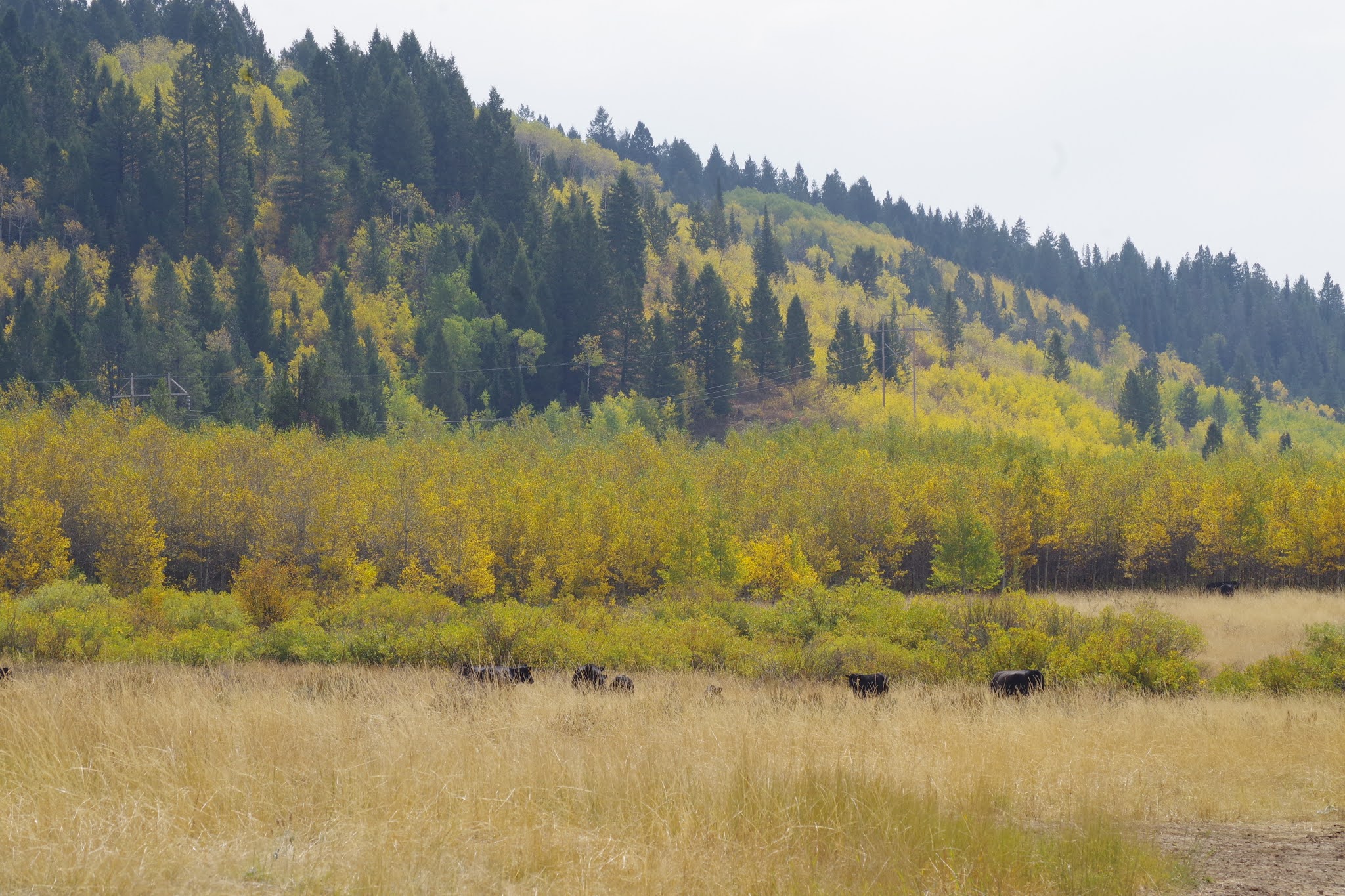
Caribou-Targhee National Forest, taken on Tuesday.  

Big-toothed maple trees glowing between Soda Springs and Lava Hot Springs 

Hi all, 

This week for my outdoor tip, I'd recommend taking a scenic drive to enjoy fall colors, which are really starting to pop in the higher elevations! 

I had a business trip to Southeast Idaho this week, and I was surprised and amazed how beautiful the colors were, especially as I went from Lava Hot Springs, south of Pocatello, toward Soda Springs. The big-toothed maple trees in the Portneuf Mountains, Bannock Mountains and other ranges in Southeast Idaho are turning deep red. Aspens are turning yellow, and cottonwoods are also beginning to take on a golden glow. The time is now! 

Visit Idaho lists two scenic drives in SE Idaho. I'd recommend the Oregon Trail - Bear Lake Scenic Highway , which goes from Lava Hot Springs to Soda Springs, Montpelier then Bear Lake. All interesting and scenic spots, a bit off the beaten track. 

With fires burning in the South Hills, the City of Rocks to Oakley scenic byway is out of the question. Fall colors may be popping in the Ketchum-Sun Valley area and Stanley. My friend Cheryl Bennett posted a few pics on a horseback ride this week in the East Fork Big Wood area, and the aspens and cottonwoods were turning a brilliant yellow. 

Courtesy Cheryl Bennett 

Here's a post I did last year on five Idaho scenic drives, which features a number of scenic drives in SW Idaho and N. Idaho. 

Clearwater River country 

Here are scenic drives in Southern Idaho ... see VisitIdaho.com for more information.  

Cobb Peak in the Pioneer Mountains, courtesy Cheryl Bennett 

Thursday, October 20, 2016

Try camping in an Idaho fire lookout tower - "Sanctuaries at the edge of the Sky"

Full moon, a warm place to sleep and a nice campfire ... how can you go wrong? 
Hi all,

I wrote a story that was published today by VisitIdaho about camping at an Idaho fire lookout. Two friends and I backpacked into Arid Peak Lookout in the St. Joe River Country, near Avery, Idaho, in September. We had a great time!

I was inspired to write this story by a great program on Outdoor Idaho about Idaho fire lookouts that have been restored by volunteers and made available for public rental.

If you'd like to rent a fire lookout, go to recreation.gov and look for an Idaho lookout of your choice. There are about 10-12 of them available to rent statewide. Act early because they book up all summer long!

Have fun!
- SS

Thursday, January 9, 2014

Hi Ho! Go play in the snow! Latest storms create lots of fun for xc skiing, snowshoeing and more!

Fresh pow! 
Time to find fresh tracks this weekend. Be safe out there! 
Hi all,

The slow start to winter this year has certainly tried my patience, and I'm sure you feel the same way. But finally, we got a great dose of snow in the last few days, with more on the way, so it's time to get out and play in the snow!

The kids already get that as they've been making snowmen and sledding in the foothills. But finally, there's enough snow in the mountains to enjoy xc skiing, snowshoeing, backcountry skiing and alpine skiing.

Leo Hennessy of the Idaho Department of Parks and Recreation tells me the Idaho City Park n' Ski Areas got hit with 14 inches of new snow in the last two days! Finally, they'll be able to groom more than 35K's of trails in the area. Leo said they'll be grooming through the weekend to make sure they get all of the trails smoothed out and ready to xc ski or snowshoe.

But this means that all of the key Park n' Ski Areas, including Gold Fork, Skyline Loop, Banner Ridge Loop, Whoop 'em Up and the trails leading up to Stargaze Yurt are all ready and poised for you to enjoy.
Getting read to skin up to Stargaze Yurt 
Getting there: Go east of Boise on Idaho 21 to Idaho City. Stop at the Sinclair gas station in Idaho City to pick up a Park n' Ski pass (either daily or season passes are available). A three-day pass costs $7.50 and a season pass costs $25. Pretty cheap, and the parking passes pay for the grooming operations, so it's a good cause.

Mores Creek Summit received another 5 inches of snow in the last 24 hours. And there's more on the way. So Pilot Peak, Sunset Mountain and Freeman Peak should all be great skiing. That's where I'm going to go! Be safe, dig a pit and check on avalanche conditions before you ski down.

High winds coming Saturday afternoon: I'd get out and play in the snow today and early tomorrow, because Saturday afternoon, high winds are moving in from the West Coast, and that may create white-out conditions and severe avalanche issues.

Here's the high-wind winter storm warning from the National Weather Service ... * SNOWFALL AND WIND... STORM TOTAL SNOWFALL AMOUNTS OF 6 TO 12 INCHES BY SATURDAY NIGHT. MANY AREAS NORTH AND WEST OF SUN VALLEY POSSIBLY COULD SEE 15 TO 20 INCHES. SUSTAINED WINDS OF 20 TO 40 MPH AND GUSTS IN EXCESS OF 50 MPH ESPECIALLY FOR THE HIGHEST ELEVATIONS. 

* LOCATIONS INCLUDE... SUN VALLEY... KETCHUM... GALENA SUMMIT... STANLEY... .BANNER SUMMIT... SMILEY CREEK AND COPPER BASIN.
The lucky ducks who have the yurts booked this weekend are going to have a blast! 
In the Idaho Statesman Outdoors section on Thursday, I read the following snow forecasts coming up for the greater SW area through the weekend:

Sock it to us, I say to the great Ullr, the snow Norwegian snow god. Bring it on! 

New snow also provides a fresh base on the xc ski trails in McCall and the Wood River Valley. 

McCall Nordic reported 4 inches of new snow today. All of the trails at Ponderosa State Park, Bear Basin and Jug Mountain Ranch have been freshly groomed for you to enjoy. If you're going to be in McCall, the xc skiing should be sweet! 

In the Wood River Valley, the Blaine County Recreation District reports improved conditions with fresh snow. The entire Harriman Trail is being groomed from Galena Lodge to Sawtooth NRA headquarters. Prairie Creek is open. Most of the lower valley trails are still closed. Alturas Lake xc trails are groomed and ready to go, too ... wouldn't that be a nice place to go!

Have fun out there! Hope you get some fresh tracks!
- SS

Thursday, August 8, 2013

Camp overnight at Bogus Basin; Go hiking, biking or running in the cool hours the next morning

Kelly Bachman enjoys Elk Meadows Trail at Bogus Basin 
Lupine and penstemon 
Wendy and Liz hiked up summit via Lodge Trail from Pioneer Lodge 
Looking off to the rooftop of the Boise National Forest 
Looking north over to Mores Mountain 
Trail-runners by Stack Rock (courtesy The Pulse)
My son Drew on the Deer Point Trail 
Hi all,

I camped at Shafer Butte Picnic Area a few weeks ago with some friends on a Friday night, and it turned out to be a great way to beat the heat. Bring your mountain bike, hiking shoes or trail-running shoes and go for an adventure the next morning during the cool hours of the day. If you have time, spend a couple of nights up there, and you'll really be able to cover some ground.

Getting there: Take Bogus Basin Road from the north end of Boise  to Bogus Basin Mountain Recreation Area. Keep going on the dirt road past the day lodge and for several miles past the Nordic Lodge, and you'll see a signed turnoff for the Shafer Butte Picnic Area.

Here are some suggestions on mountain biking, hiking and trail-running trips in the Bogus Basin area:

1. Hike to the top of Mores Mountain - Since you're already there at the trailhead at Shafer Butte Picnic Area, this is the most obvious and convenient hike close to camp. Very kid friendly. It's .75 miles to the top and 400 vertical feet. There is some educational information on the interpretive trail by the trailhead -- stuff about plants, flowers and shrubs.

2. Mores Mountain - Bogus Basin Contour Trail combo mountain bike ride - Ride the Mores Mountain Trail from the picnic area/campground. It's mostly downhill, and it has a bunch of whoop-dee-do's in the trail for a little air time. Go left at the junction with the Boise Ridge Road, climb back to the base area of the ski resort, take Deer Point Trail #91 to the top, pick up Elk Meadows Trail #94, and contour around the backside of the ski area. After the Elk Meadows singletrack joins a contour road, follow the road under Superior Chair #3, and then take the switchbacks to the top of Bogus for a great lunch spot. Then take the switchbacks back to the contour road junction, and drop down to your campsite at the picnic area. The ride is about 14 miles and features several thousand feet of vertical gain. Here's a Shafer Butte trail map for reference.

3. Trail-runner special: Twin Peaks at Bogus Basin Loop - This is a 9-mile trail run. Rated strenuous. Do the Mores Mountain Loop, and when you return to the picnic area, climb a dirt road and the switchbacks to the top of Shafer Butte. Then descend back to your campsite. The run takes about 2 hours, and it features 2,509 feet of vertical gain. Thanks to Lynette McDougal for logging this one for my Boise Trail Guide. 

4. Hike, bike or run Freddy's Stack Rock Trail - This route is 9.5 miles, from the turnout on Bogus Basin Road that accesses Freddy's Stack Rock Trail and Eastside Trail. The parking area is close to mile 12 on Bogus Basin Road. Drop down the singletrack from the parking area to Eastside Trail. Go west on Eastside and do the loop around Freddy's Stack Rock Trail. Retrace your tracks to the trailhead. This hike/run/bike ride is fairly strenuous ... it features 2,676 feet of vertical gain. The route is featured in the Boise Trail Guide and Mountain Biking in Boise. 

5. Mondo mountain bike ride - Ride the Mores Mountain Trail, take the ridge road back to the Bogus base area, climb Deer Point Trail #91, then go right at the top over to Deer Point and drop down the Boise Ridge Road .9 miles to the Mahalo Trail via Forest Road #275C on the left. Do the Mahalo Loop, turn left when you reach the Boise Ridge Road, and descend a couple of miles to the Dry Creek Trail turnoff on the right. Descend Dry Creek Trail about 8 miles to Bogus Basin Road. Return to Boise.

6. Long hike - For those thirsting for a longer day on the trail, go to the top of Shafer Butte from the picnic area via the two-track road and the switchbacks to the summit. Here's a Shafer Butte trail map for reference. Take "the Face" Trail #93 downhill to a saddle, and follow "Shindig" Trail #92 to the bottom of Bogus Basin. Then climb Deer Point Trail #91 to Elk Meadows #94 and follow Elk Meadows around the mountain back to a dirt road that descends to the picnic area/campground. This would be a good trail-run, too. You've earned your dinner!

There you have it! Beat the heat and enjoy the trails at Bogus Basin. I bet there are still a few wildflowers to be found.
------------------------
Reminders on fun events coming up:

- SS

Thursday, July 18, 2013

Try any of these three backpacking destinations in Central Idaho ... they're Idaho classics!

Fishfin Ridge in the Bighorn Crags (courtesy Summit Post) 
Wilson Lake, Bighorn Crags (courtesy Will Whelan)
Scenic hiking! Bighorn Crags
Alice Lake, Sawtooth Wilderness 
Hatchet Lake, Boulder Chain Lakes, White Cloud Mountains (courtesy Idaho Alpine Zone)
Hi all,

It's mid-July, nearly all of the snow has melted in the high-country, so the backpacking season is in full swing. This week, I'm going to highlight three backpacking trips in Central Idaho that I'd call "Idaho classics." Try to make plans and pick these off when you can. They are all stunningly beautiful and certainly worth the effort!

All of these backpacking trips end up at high mountain lakes where you can cool off and go swimming and/or go fishing. That's the big payoff. Plus, you have the option of hiking to high peaks or ridges above the lakes for a big view.

1. Alice Lake-Toxaway Lake Loop in the Sawtooth Wilderness. This loop is approximately 18-miles long, with 3,250 feet of elevation gain and loss. The trailhead starts from Pettit Lake, south of the Smiley Creek Lodge. A three-day trip for this loop would be great to allow time to enjoy the high mountain lakes before hiking back to your rig, but it certainly can be done in two days. I'd rate the hike strenuous.

Alice-Toxaway Loop (click to enlarge)
2. Boulder Chain Lakes in the White Cloud Mountains. This trip is also strenuous, but well worth it to get into the Boulder Chain Lakes in the Little Boulder Creek drainage. It's about 8+ miles to the first group of lakes, and another mile and more elevation to the upper lakes. Elevation gain is 3,500 feet to the upper basin. The cool aspect of this destination is the amazing choice of so many lakes to explore and consider for that premium lakeshore camp site. There are more than 10 lakes in the general area, once you reach the Boulder Chain Lakes Basin.

The only drawback to this trip is the time it takes to get to the trailhead. The best way to do it is to drive to Stanley on a Friday evening, and keep going toward Challis to the East Fork of the Salmon River Road (Forest Road #120) near Clayton. Go right up the East Fork Road and camp at the trailhead. It's about 4 hours to the trailhead.

Boulder Chain Lakes in the Little Boulder Creek drainage. 
3. Bighorn Crags in the Frank Church-River of No Return Wilderness. The drive to the Crags is even longer ... it takes at least a half day to get there, so it's best to plan a trip in the Crags for 4-5 days, or even a full week. Drive to Challis, go north of town, and turn left onto the Morgan Creek Road. Take the Morgan Creek Road over a summit into Panther Creek, then go left on Forest Road #112 in Cobalt and climb up to the Crags Campground Trailhead. It's 47.6 miles of dirt road to the trailhead.

From there, it's a strenuous hike of 7+ miles to Wilson Lake and Fishfin Ridge, a good place for the first night's camp. The main destination that a lot of people seek is Ship Island Lake, a huge, long lake that's set deep in the heart of the Crags. Like I said, allow plenty of time to explore the area.

Crags campground to Ship Island Lake (click to enlarge)
Here's what my friend Will Whelan says about the Crags:

 "The Crags are fairly similar to the Sawtooths, but a couple of differences stand out: 1) The Crags are embedded in a huge wilderness, and it takes hours of driving on dirt roads to even get there. As a result, the place has a really remote feel. No lights at night. 2) The free-standing vertical spires at places such as Fishfin Ridge are really remarkable. In places, they are tightly stacked together, making for very entertaining hiking as you pass in and around the jumbled landscape."

When it comes to backpacking, Idaho has a ton of great adventure opportunities throughout the state. There are many other places you can go, but these three are some of my all-time favorites. They are challenging to be sure, but the payoff in terms of scenery and fishing make everything worthwhile.

Have fun!
- SS

Thursday, June 20, 2013

It's not too late! Celebrate Idaho's rivers by planning a "staycation" on our four best rivers

Ah, rafting on the Salmon River! Life is good! 
Kids reading books? No electronics to divert their attention ... 
The historic Jim Moore homestead on the Salmon River near Campbell's Ferry. 
Dutch oven cooking! 
Happy people! 
Hiking! This is Amanda Damon from Rhode Island. She'd never seen so many mountains ...  
The kids love paddling the double ducky. Thanks Mark! 
Hi all,

After posting pictures from our recent trip on the Main Salmon River - River of No Return, I heard some people say things like "jealous!" and "wish I could go" and of course "beautiful!"

We are blessed with a bounty of awesome, wilderness river trips in Idaho, and the Main Salmon is one of the crown jewels. I also heartily recommend doing a trip on the Salmon, the Middle Fork of the Salmon River, the Selway River and Hells Canyon of the Snake.

It's not too late! There's still plenty of time to plan or book a whitewater wilderness vacation with your friends and family. Given how dry it's been this spring, the experts are predicting a big wildfire season in late summer. You'd be smart to plan a river trip in July, if at all possible.

Who go? The Main Salmon is arguably one of the best family wilderness whitewater vacations in America. And it's located right here in our home state in Central Idaho. You camp on spacious beaches with lots of shade afforded by tall stately pine trees. You get to play on the river during the day, and then you can set up the volleyball net on the beach, play bocce ball, hang out and enjoy the scenery, and more. Plus, there's hot springs, history, and Buckskin Bill's and Mackay Bar, where you can buy fresh ice cream for your kids.

River trips are one of the cushiest forms of camping you can imagine. Instead of hauling all of your food and clothes on your back such as in backpacking, the raft carries all the weight. You can bring iced coolers with just about any food items you want, plus you can carry plenty of favorite beverages for the kids and adults.

As you're enjoying the float trip during the week, the members of your floating party bond and get to know each other on a much more personal basis. You will make lifelong friends on the river. And you will fall in love with the river canyon.

The Main Salmon is best suited for families and novice boaters because the rapids are not as hard to navigate as they are on the Middle Fork, Hells Canyon or the Selway. Follow an experienced boater down the river, and you'll learn a ton. My cousin from Rhode Island learned how to row a raft on our Main Salmon trip, and by the time he reached the end of the trip, he had learned a ton, including how to self-rescue in the middle of a rapids! (Chittam).

For the do-it-yourself boating community, the hardest part of getting on the Main Salmon, Middle Fork, Selway or Hells Canyon is drawing a permit. I picked up a cancelation for June 10th in April from recreation.gov, so I had plenty of time to plan a trip and pull together a diverse party of 16 people.

If you still don't have a permit for this summer, watch the recreation.gov web site for last-minute cancelations, and grab a date that works for you. It will likely be easiest to find cancelations on the Main Salmon or Hells Canyon. The Middle Fork will have some cancelations, particularly in later summer, and the Selway is unlikely to have any cancelations, as only 1 launch is allowed per day.

The second way to book a river trip is to go with an outfitter. Idaho is blessed with a multitude of quality outfitters. As longtime businesses operated on Idaho's best rivers, the outfitters receive an allocation of permits for their trips. So you don't need to draw a permit to go with them. You just have to pay the trip fee, which is usually about $1,500 per person. Go to the Idaho Outfitters and Guides Association web site, and shop for an outfitted river trip.

Other options are to float the Lower Salmon River below Whitebird to Hells Canyon. This section of river is a great trip for kids and families, and nothing more than a self-issue permit is needed. This is a 4- or 5-day trip, depending on how fast you want to go.

Other possibilities would be to float the Grand Ronde River or John Day River in Eastern Oregon, or the South Fork of the Snake River in Eastern Idaho.
------------------------------------------
Reminder: the SWIMBA Trail Rendezvous runs from 3-9 p.m. on Saturday at the Eagle Cycle Park.
This is a fund-raising event for SWIMBA's quest to purchase a singletrack trail-cutting machine. They are only $9,000 short of their goal. Sockeye brewing is donating all proceeds from beer sales to SWIMBA. Sockeye has created a new beer called "Trail Digger Pale Ale." I'm going to head over there to drink some beer and support the addition of more singletrack trails in SW Idaho.

Also, see Roger Phillips rundown in the Statesman of a bunch of must-see, must-do cycling events coming up this summer. Thanks Roger!

One of those events is the Blue Cruise, a road ride of 15, 30, 50 and 100 miles, starting in Meridian. The ride this year will benefit low-income kids who need bikes. Donate your old bikes to Blue Cross or the Boise Bicycle Project, and BBP will recycle them for the Bikes for Kids event in late July. More information here.    

Outdoorsy folks in Cascade are getting quite creative with a new event called the Payette River Games. There are all kinds of competitive events going on in Cascade at Kelly's Whitewater Park and other venue, including a kayak competition, beach volleyball, bocce ball, golf, lumberjack, fitness, yoga, you name it! It starts on Friday and runs through Sunday.

Have fun!
-SS

Thursday, April 14, 2011

It's official: Boise Foothills trails are ready to enjoy

Google Earth GPS route of Cross-Foothills Route; click to enlarge
Hi all,

I checked on the Ridge to Rivers web site earlier this week to check on Boise Foothills trail conditions, and the headline was, "Trails are mostly dry." After all the rain in the last month, that's great news! We've got the official green light to go hiking, running or biking on foothills trails.

So I dashed out for a mountain bike ride on Tuesday afternoon, and indeed, the trails were bone dry. I went on a cross-foothills ride today (more on that in a moment), and the trails were mostly dry. Of course, as the Ridge to Rivers trail report points out, conditions can change when rain is in the forecast. There's a 50 percent chance of rain on Saturday, for instance. Be sure to give the trails a chance to dry out after a storm.

In the meantime, seize the day and head out on the trails. You'll hear the sound of meadowlarks, and the creeks roaring with snowmelt. Red-tailed hawks are soaring in the fresh winds, searching for prey. Foothills grasses are turning green and shrubs beginning to bloom. Spring is in the air!

It's always interesting to see how the legs and lungs have fared over the winter during the ski season. If you're like me, you've got some lung power, but the quads aren't that used to climbing long steeps. Winter road biking helps. But you've pretty much got to go mountain biking for real to get in mountain biking shape. Same goes for hiking and running.

So if you haven't been training for the Race to Robie Creek (the race is Saturday!) for the last month, take it easy at the beginning of the season and tackle some easier hikes, runs and bike rides to get the body tuned up for the summer.

I've got some recommendations from Mountain Biking in Boise and Boise Trail Guide. The main thing right now is to focus on the mid- to lower foothills trails. The upper trails and the Boise Ridge Road are still snow-bound. The trails in the mid- to upper foothills, such as the Watchman Trail, are still wet and greasy in some places, so it's best to wait for them to dry in the coming weeks.

  • Cross-Foothills Ride (Intermediate; strenuous in places) - 10 miles. 2 hours riding time. Today, I rode up to the Corrals Trail (trailhead is 1.8 miles north of Curling Drive on Bogus Basin Road), rode Corrals to Corrals Summit, and then rode downhill on Corrals and Trail #1 over to Hulls Gulch. Then I took Crestline to Military Reserve, and dropped out on the Freestone Creek Trail in Military Reserve near Fort Boise. The hardest part of the ride is climbing to Corrals Summit (3 miles uphill from trailhead, 1,200 feet of vertical gain). Then it's mostly downhill to Military Reserve, with a few uphill sections in between. Fun ride! Hardy mountain trail runners would enjoy that route as well.

  • Jumpin' Jeepers Figure 8 Loop - (Intermediate/Moderate) 6.75 miles. 1+ hour riding time; 2.5-3 hours hiking time; 1:15 running time. This hike and bike ride are featured in my guidebooks Boise Trail Guide and Mountain Biking in Boise. It's a Figure 8 loop as the name suggests, starting from Military Reserve Trailhead on Mountain Cove Road, climbing the Toll Road Trail #20 to the Central Ridge Trail #22. Follow Central Ridge to Shane's Junction. Turn left and ride Shane's Loop clockwise. Back at the Shane's-Central Ridge Junction, bear right on Bucktail Trail #20A, and take the lower part of Central Ridge #22 back to the trailhead. Be aware that police officers practice firearms training at the end of Mountain Cove Road, very close to Bucktail Trail. I've jumped out of my skin a few times when enjoying the quietude, and then, "bang!"

  • Military Reserve Double Ridge Loop - 3.7 miles. Moderate. 1.5 hours hiking time; 45-50 minutes jogging time; 45 minutes riding time. This one is even easier. You go to the Military Reserve Trailhead near Fort Boise on Mountain Cove Road, go uphill on Central Ridge Trail #22, turn right on Ridge Crest #20A, take that to the bottom of the hill, go left on Eagle Ridge Trail #25, and do a short loop on Eagle Ridge. Drop down the hill to the trail by the dog park, and return to the trailhead.

  • Crestline-Hulls Loop - 7.25 miles. Moderate. 2.5 hours hiking time; 1.5 hours running time; 1.25 hours riding time. Start from Camelsback Park in Boise on N. 13th. Find the trailhead behind the tennis courts. Climb on Owls Roost and Kestrel to Crestline. Follow Crestline to the Hulls Gulch Junction. Turn left and descend on Hulls Gulch. It's rocky and uneven in places. When you reach the 8th Street trailhead by the Foothills Learning Center, turn right, cross 8th Street, and finish the ride on Red Fox Trail, which leads you back to Camelsback Park.

  • Seaman's Gulch Double Loop - 3 miles total. 1+ hours hiking time; 30-45 minutes running time; 30 minutes riding time. This one is the easiest of the routes listed here. Take Hill Road west in Boise to the Seaman's Gulch/Hidden Springs right-hand turnoff. Go right and follow Seaman's Gulch Road to a nice paved parking area and rest room next to a large water tank. Take the Valley View Trail #111 to the right, and then take the first left on Trail #110 to Phlox Trail #112, turn left and return to the trailhead for a one-mile short loop. Now go back on Valley View, and keep going out to the true "valley view" viewpoint provided by the trail, hanging above the Boise Valley. The trail loops around to Phlox and returns to the trailhead.
Please see the Ridge to Rivers map or check out my books for more hiking, biking and trail-running possibilities in the Boise Foothills. The Boise Trail Guide features 76 hikes and trail runs within an hour of Boise, including routes on the Boise River Greenbelt, the Owyhees, along the Snake River, the Boise Foothills and in the Boise National Forest.

Mountain Biking in Boise provides a guide to 65 rides in the immediate vicinity of Boise, including the foothills, Bogus Basin, Stack Rock area, Avimor and Oregon Trail.

In case you didn't know, you can buy digital color files of individual hiking, biking and paddling trips on my web site now for .99 cents each, in bundles of 5, 10, 15, or the whole book as an e-book. See more at www.stevestuebner.com.

Have fun!
- SS

Steve shares his weekly outdoor tips with Ken and Tim on 94.9 FM The River each Friday morning at approximately 7:10 a.m. If you miss the program, you can hear the segments on River Interactive.com.

Thursday, August 12, 2010

Backcountry 4WD roads provide great access to Central Idaho spectacular high country

Loon Creek, clean and pure

View looking down Loon Creek from our campsite

Grouse Creek open-pit gold mine ... never got very far

Black bear feeding on berries in the creek bottom

Near Loon Creek Summit. The General is on the left.

Small rainbow amid black sky


Crater Lake, just 1,500 verts downhill from Railroad Ridge

Wendy loved all of the flowers, as did I


I love my truck!

The road to Railroad Ridge was definitely a 4WD low-range type of road


My partner Wendy had knee surgery recently, so we decided to take a different approach to accessing the high mountains of Central Idaho -- we took the truck to the top.

Normally, we'd be backpacking into the high country at this time of year, but Wendy's physical therapist would have given her hell if she tried to put in 15+ miles on a rugged backcountry trail with a full-on backpack.

So we packed up my 1990 Ford F-150 4WD, which has traveled many super-gnarly rock-strewn roads in Owyhee County, and headed out for Railroad Ridge in the White Cloud Mountains. We also planned to drive a twisty single-lane 4WD road from Yankee Fork into the headwaters of Loon Creek, if we had time, over a three-day weekend.

Why go? We yearned to see mountain wildflowers at their peak, fly fish for trout, and camp in the high country, where it's nice and cool, even in August. Most of all, we needed to get out of town and get a change of scenery!

Idaho has a great roster of backcountry byways. Those routes typically include excellent access to food, lodging and services. More primitive trips like the two I'm going to describe here are just that, primitive. You're traveling into the backcountry where there are zero services. It's a pack-in, pack-out situation. We brought 10 gallons of water, our camp cook stuff, food, fishing stuff, tent and sleeping bags, etc.

Railroad Ridge. We left on a Thursday night after work, camped in a meadow near Stanley, and headed up to Railroad Ridge on the east slope of the White Clouds the next morning. It's such a long drive to the trailhead (4 hours) that it's great to do part of it the night before.

Getting there: Take Idaho 21 to Stanley, and Idaho 75 past Yankee Fork and Clayton to the turnoff for the East Fork of the Salmon River Road. Head up the paved East Fork Road about 10 miles to Big Boulder Road #667. Go right on #667 and proceed to the Livingston Mill. A Forest Service sign indicates the turnoff for the more primitive single-lane 4WD road to Railroad Ridge. You, no, the truck, must climb from 7,200 feet to elevation 10,600 feet, 3,400 feet of gain over just a few miles of steep road.

The 4WD road to Railroad Ridge is very narrow with almost zero pullouts. I just put it in 4WD low-range and cruised up the road at a slow speed, careful to not pop the tires on sharp rocks and slowly navigate big water dips and large boulders. It took us, no, the truck, less than an hour of climbing and we were cruising up the backbone of Railroad Ridge, which was absolutely smothered with multiple layers and colors of wildflowers. We hit it at the peak! Sweet!

Perched at 10,600 feet, it was so cool to look at eye level with 10,000-foot peaks in the Sawtooths to the west, and the Frank Church Wilderness to the north, while the higher Lost River Range and Lemhi Mountains lorded over the eastern side of the state.

I hiked down to Crater Lake to fly fish, just in time for a thunderstorm to hit and lightning bolts to land around the edges of the lake. We had a great evening watching a storm hammer the Lemhi's and the Borah Peak area, and then we pitched the tent because the storm ended up hitting us pretty squarely by 10ish. Our REI river tent fared pretty well on that windy ridge ... should have brought the NorthFace VE-25, but it was August!

It was clear as a bell the next morning. Wendy saw 40 head of elk on Railroad Ridge to the east, and spotted a lone mountain goat on a peak nearby. Very few birds were visible in the area except for a few red-tailed hawks.

Yankee Fork to Loon Creek: On Saturday morning, we noted the storm clouds gathering quickly in the White Clouds again, so we headed for the Loon Creek Trailhead, 25 miles from Bonanza, up the Yankee Fork Road.

Getting there: We were already in the 'hood. We took ID 75 to the Yankee Fork road, drove north on Yankee Fork to the dredge, turned left on the Jordan Creek-Loon Creek Road #172, and cruised over a tall summit to the Loon Creek trailhead, just past the Diamond D Ranch.

We got there in the early afternoon. I didn't waste any time getting my fly rod set up to fish the turquoise stream. Last time I was there, photographer Mark Lisk and I hammered the cutthroat trout with Dave's Hoppers in 90-degree heat. This time around, the fish were more choosy, but I still had some action.

There is a nice hot springs about 4 miles up the Loon Creek Trail, but Wendy couldn't quite hike that far (8+ miles round-trip), so we pulled over after a while and hung out at a deep pool, taking a swim every so often to cool off (after I was done fishing, of course).

If one were nuts about backcountry roads and could take the bumpy ride for hours on end, we could have driven to the top of Pinyon Peak (9,942 feet), a remote Forest Service fire lookout on the edge of the Frank Church Wilderness. That lookout is accessible from the Loon Creek Road or from the Beaver Creek road system, north of Cape Horn.

On our way back, we stopped at the top of Loon Creek Summit, and hiked out the shoulder of a mountain to the west and had a great view of the General, a big 10,000-foot peak, and the old Grouse Creek open-pit gold mine, not to mention all of the other mountains in Central Idaho.

We were a bit dizzy from all the twisty road by the time we got back to the paved Idaho 21, but we had covered a lot of country and taken lots of great photos. We figured the trip was good practice for when our knees or hips are worn out in our late 70s or 80s. :)
- SS
Thursday, June 10, 2010

Route of the Hiawatha near Wallace is a sure bet for a unique biking experience

The 15-mile trail is family friendly

Bring bright halogen lights if you have them

Riding the high trestles

Some of the high trestles are more than 200 feet high

One of the shorter tunnels (photos courtesy Lookout Pass Ski & Recreation Area)

Hi all,

I've always felt that the Route of the Hiawatha Rail-Trail near Wallace, Idaho, is one of the neatest rail-trails imaginable. I've ridden it several times since it was opened in the mid-1990s, and I even had the opportunity to do an early test ride on the trail before it was open to the public. Every time I rode it, I thought it was an invigorating and beautiful biking adventure.

The reason it's so cool is you ride through 10 unlit tunnels, including the 1.7-mile-long St. Paul Pass tunnel, and seven high trestles as part of the 15-mile trail. If you take a shuttle, the ride is completely downhill, and it's totally family friendly.

This week, USA Today published an article about the top 10 rail-trails in the United States, and the Route of the Hiawatha was listed as numero uno!

So when you're planning your vacations or long weekend getaways this summer, try to work in a long weekend in the Wallace or St. Maries area and ride the Route of the Hiawatha. The trail is managed by Lookout Pass Ski Resort, located on the Idaho-Montana border on I-90. Lookout Pass provides shuttles, trail passes, etc. The ride is featured in my Falcon Guide Mountain Biking Idaho.

Here's a video about the trail and the railroad history. Believe it or not, former Sen. Larry Craig, R-Idaho, had a big hand in obtaining federal funds to develop the old railroad line into a rail-trail. There was a very progressive recreation officer working for the St. Joe National Forest at the time when the trail was only an idea, and she worked closely with lots of people in Wallace and St. Maries to create the trail and a new tourism draw in a town that was reeling from the decline of the mining industry. It's always sweet to see a dream project become a reality.

You stay in the Wallace Inn (formerly the Best Western) or other lodging properties in Wallace while you're in the neighborhood, and check out the Oasis Bordello Museum, or you can camp at the foot of the trail by traveling from St. Maries up the placid and scenic St. Joe River (fly fishing is good!) and pitch a tent in the national forest. Bring a canoe if you'd like to paddle the St. Joe as a side trip opportunity.

Be sure to bring BRIGHT and POWERFUL lights for riding in the dark tunnels, if you have them. Lookout Pass has lights available for rent for $5, plus they have bikes and helmets available for rent, if you don't want to take your own. I've found that night-riding mountain biking lights work great.

More experienced bike riders will enjoy the challenge of riding the Route of the Hiawatha from the Pearson Trailhead, near Avery, in the St. Joe drainage. It's 13 miles uphill at only a 2 percent grade, and then 1.7 miles of riding through the St. Paul Pass tunnel on the Idaho-Montana border, for a total of 15 miles. Then you can turn around and cruise downhill back to Pearson, for a 30-mile ride. It took me less than an hour to climb the trail, and about a half hour to zoom down it, pedaling all the way.

While you're in the 'hood, take some time to ride the Trail of the Coeur d'Alenes, a fairly new paved trail along the Coeur d'Alene River. You can access the 71-mile trail in Mullan, just up the hill from Wallace, and ride downriver to Harrison and Heyburn State Park, if you want to ride the whole thing.

If you bring the kids, you have to stop at Silverwood Theme Park, north of Coeur d'Alene, where you can enjoy 65 rides, including roller-coasters, insanely steep and fast rides, and water slides. Silver Mountain in Kellogg also has a new indoor water park that the kids would enjoy.

As you can surmise, it'd be easy to spend a week in the Silver Valley-Coeur d'Alene area for a great and affordable Idaho staycation. Have fun!

- SS