Friday, December 17, 2021

Winter finally arrives with a powder bang! Downhill skiing, xc skiing, snowshoeing, snow biking are doable right now!

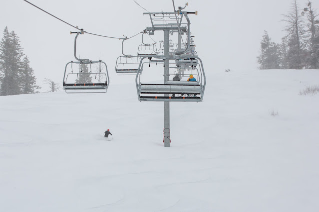
Mid-week pow day at Bogus Basin. Private Idaho! 

Hi all, 

Well, Old Man Winter, or perhaps it was the Norwegian Snow God, Ullr, took his time to wake up from a long summer snooze, but in the last 5-10 days winter has kicked with a major powder bang statewide, thank goodness! 

In the Central Mountains, West-Central Mountains, and Boise Mountains, 2.5-3 feet of new snow has fallen or more, depending on location, and that has suddenly allowed most of Idaho's ski areas to open for the season, plus that snowfall has put the mountains in shape for xc skiing, snowshoeing and snow-biking. 

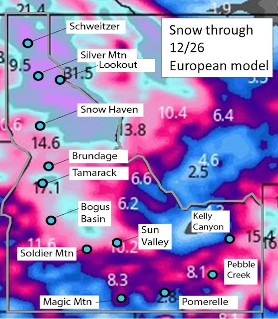
See my post at the Idaho Daily Snow for the latest snow forecasts for Idaho. 

Earlier this week, Bogus Basin opened the Pine Creek chairlift for the season, and on Saturday, they'll open Bitterroot and Superior lifts, basically the whole mountain. Fun fun fun! Might even have some sunshine at Bogus this weekend on Friday and Saturday. Bogus is reporting a 25-inch base, with 7" in the last 24 hours, and six lifts in operation. Remember it's still early-season conditions. 

Brundage Mountain Resort and Tamarack Resort opened on Tuesday of this week with over 30" of new snow since the previous Friday ... from "zero to hero," is how spokeswoman April Whitney put it for Brundage. Tamarack got even more snow than Brundage in that series of storms, and it was amazing for skiers/riders to enjoy copious amounts of powder on opening day! 

Sun Valley, Galena Summit and the Wood River Valley also have shared in the powder goods, with over 2.5 feet of new snow falling in that area and counting. That has allowed the Galena and BCRD to groom a large portion of the Wood River and Galena Lodge xc trail system. They're open 7 days a week. 

The McCall Nordic report indicates that all of the key xc areas are working on getting up and running, including Ponderosa State Park, Bear Basin, Tamarack Resort Jug Mountain Ranch.

I have not gotten a report from the Idaho City Park and Ski areas, but I saw that the Mores Creek Snotel site has 34 inches of snow near Mores Creek Summit, so all of that area should be in good shape for xc skiing, snowshoeing and backcountry skiing. Try to find a grooming report to see if IDPR has been up there grooming trails to the backcountry yurts. 

Be aware that there's substantial avalanche danger following the big snow storms! See the latest reports from the Sawtooth Avalanche Center and Payette Avalanche Center. It may be best to stick to lower-gradient slopes and do some touring to avoid any potential danger. 

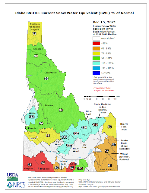
In case you were wondering, interesting to see the latest Idaho snowpack map ... we are catching up! 


Snow forecast in Idaho through 12/26. These are cumulative totals from today. 


Thursday, December 2, 2021

With sunny afternoons through Sunday, enjoy low-elevation trails like the Wilson-Reynolds Loop in the Owyhees

Entrance to Reynolds Creek canyon from the north. Took this pic in the spring.


Hi all, 

One more week of this unseasonably warm weather in December before winter weather is forecast to descend on Idaho next week.

So you might as well continue to enjoy low-elevation trails in the Boise Foothills or the Owyhee Front.  Please keep tabs on the Ridge to Rivers Facebook page for the latest trail conditions ... trails that are on north slopes or in permanent shade are going to be muddy and should be avoided. 

Trails in the Snake River canyon, such as this recent post detailing trips to an old homestead or Celebration Park to Halverson Lake would work well as would these must-do hikes in the Owyhees - Leslie Gulch and Mary's Creek/Sheep Creek.   

The China Ditch Trail ... Courtesy Idaho Hiking Club

Another sweet hiking loop is the Wilson Creek-Reynolds Creek Loop, which is featured in both my Boise Trail Guide and Owyhee Canyonlands guidebooks. It's 7.5 miles round-trip, travel time about 3.5 hours, vertical gain 750 feet, and it's super scenic. I saw that the Idaho Hike Club hiked it earlier this week. 

Here's a description in All Trails as well. 

My writeup on the hike:  

General remarks: This is a great hike/trail run in the foothills of the Owyhee Mountains, about 45 minutes from Boise. The trail weaves through rock formations on the way over to Reynolds Creek, and then you'll hike along on top of the China Ditch Trail - an old Chinese-built irrigation ditch high above the creek. The red rock canyon is spectacular. Bring your camera, plenty of water and a lunch.

Example of the cool rock formations you'll see going over to Reynolds Creek canyon.

Getting there
: From downtown Boise, hook up with I-184 west and head for Nampa. Take the Franklin Road exit (City Center) in Nampa, and turn left. Follow Franklin to the intersection with 11th Street. Turn right and take 11th into downtown Nampa. Follow signs for Idaho 45 south. Take ID 45 to Walters Ferry at the Snake River and turn right on ID 78, heading for Marsing. In a couple miles, turn left on Wilson Creek Road. Proceed up the paved road until it turns to dirt and pull into a dirt parking area on the left for BLM Trails #300 and #400. The hike/run starts here.

Directions: To begin, pick up Trail #300 out of the parking lot. Ignore trails branching off to the left in the first mile. At mile .9, you’ll cross a road and continue on the singletrack trail. The trail climbs one last hill and then widens into a two-track and descends to a T-junction at a dirt road (mile 1.8). Go right for a short bit, and turn left on Trail #410, a sandy wash going downhill towards Reynolds Creek. At mile 2.3, go right on Trail #310 and proceed for a half mile to a junction with Trail #600, the "China Ditch” trail. Go right and walk upstream along Reynolds Creek canyon for about a long mile. After walking next to vertical rock walls, the trail opens up on the right at the junction with Trail #510, #601 and #610. Go right on #510 and climb out of the canyon. At mile 4, bear right at a Y junction on #510 and stay on #510 to BLM dirt road #37154. Go right and follow the road to the junction with Trail #400. Go left on #400 at mile 5.28 and head back to the trailhead. At the top of the first hill, you can either stay on Trail #400 or branch off on #300. Both ways head over to the Wilson Creek Road and the trailhead.

Hiking notes: Even though the route is 7+ miles, the elevation gain is pretty minimal, so the hike may be suitable for kids 8 and over. My kids enjoyed the hike, especially throwing rocks into the creek on the China Ditch trail.

Wondering what's going on with the winter storms predicted next week? See my post in opensnow.com for the Idaho Daily Snow for details. 

- SS  

Make sure you bring the kids! This was Quinn and Drew a few years ago!