Thursday, April 28, 2016

Weekend weather looks perfect for exploring Bruneau Dunes, Bruneau Canyon & Big Jacks

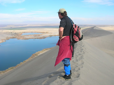
Steve on top of the dunes. Wearing boots and gators to keep sand out of shoes.
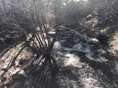
Big Jacks Creek photographed from the Parker Trail
Bruneau Canyon upriver 
Bruneau River Canyon from the Overlook (courtesy VisitIdaho.org)
Hi all,

The weekend weather promises to be partly cloudy and relatively cool, with highs in the low 70s -- perfect for hiking in the Owyhees. Last week, I recommended Wildcat Canyon near Marsing. This week, I'm recommending three outings in the Owyhees near Bruneau, south of Mountain Home.

I'm recommending Bruneau Dunes State Park, the Bruneau Canyon overlook, and Big Jack's Creek, the Parker Trail. All of these destinations are knock-your-socks-off scenic with fun exploring opportunities and optional camping. All of these destinations are detailed in my guide, Owyhee Canyonlands: An Outdoor Adventure Guide,. which features 55 hikes and bike rides in the vast, 5-million-acre area south of the Treasure Valley. 

So let's get to it!
  • Bruneau Dunes State Park - Go visit North America's tallest single-structured dune, 470 feet high. It's easy to climb up there and cross the top sandy ridgeline of the dune, and check out the other smaller dunes in the area. There's also some fishing there at the park, and the camping at Bruneau Dunes is absolutely first-class with services. Distance: 3 mile loop. Travel time: 1-2 hours at a very leisurely pace. Bring the kids! Great place for them to play. Pack a lunch. Bring plenty of food and water. Trail map here. Buy a $10 state parks pass with your vehicle registration so you can get free entry into any of Idaho's state parks year-round. Awesome deal! How to get there: Take I-84 to Mountain Home. Take the first exit and go south on Idaho 51 towards Bruneau. Cross the Snake River and then turn left and follow signs to the park.
  • Bruneau Canyon Overlook - This is another family friendly adventure to go see the yawning Bruneau River Canyon, 18 miles south of the town of Bruneau. The canyon is 800 feet deep from the top of the rim down to the rushing river. It's super cool to check out the layer-cake like geology of the canyon. Multiple layers of volcanic basalt and rhyolite are exposed in the canyon. If you don't have a copy of "Roadside Geology of Idaho," I heartily recommend it. How to get there: Take I-84 to Mountain Home. Take the first exit and go south on Idaho 51 to Bruneau. Pick up any last-minute items at the market in town, then turn left on Hot Springs Road and follow that south of town. After 8.5 miles, go left on the Clover Creek-Three Creek Road, a good-quality gravel road. 15 miles south of Bruneau, you'll see a BLM sign on the right, indicating the turn for the overlook. You could self-support camp in that area. You also could hike or bike on the two-tracks next to the overlook.  
  • Big Jack's Creek, Parker Trail - Distance: 2.5 miles; rated moderate to strenuous. Travel time: 2 hours or more. Pack a lunch and make a day out of it! Big Jacks Creek is a gorgeous, vertical redrock canyon, carved out of rhyolite lava. The Parker Trail is a rare developed trail anywhere in the Owyhee Canyonlands where a person can follow a trail tread from the canyon rim to the creek-bottom. It's about 1.25 miles down to the bottom. You'll come to a nice rock outcropping 1 mile down the trail, a nice spot for a photograph. There's a sweet campsite at the bottom of the trail next to Big Jacks Creek. So this trip has backpacking and camping potential. 


    How to get there
    From Boise, take I-84 east to Mountain Home. Take the first exit. Follow signs for Idaho State Highway 51 and Bruneau. After you reach Bruneau, take note of your odometer. Stay on Idaho 51, going south, for approximately 27 miles. You'll be watching for a right-hand turn on a good dirt road, called the Wickahoney Road, just past milepost 45. The road is not signed, but it's a BLM public road. Follow the Wickahoney Road 4.9 miles to a T-junction by Wickahoney Creek. Turn right and go 2.8 miles to the Parker Trailhead. The road is rougher for the last 2.8 miles. Higher-clearance AWD recommended. 
Have a great weekend!
-SS  

Thursday, April 21, 2016

Cooler weather ahead: Take a hike in Wildcat Canyon in the Owyhees near Marsing

Canyon entrance 


Sister canyon to Wildcat Canyon 


Wonder how this landed here? 
Rhyolite lava rock 

Hi all,

It's been a gorgeous week weather-wise in SW Idaho, with temperatures reaching into the 80s today! But change is afoot and 60s are expected this weekend. It might be wet Saturday morning, but Sunday should be a nice cool day for a hike.

I thumbed through my Owyhee Canyonlands guide, and I thought of the Wildcat Canyon loop, near Marsing. It's a 3.5-mile cross-country loop, climbing a slot canyon in Wildcat Canyon, and then descending in a canyon that runs parallel to it. Rated moderate, with some strenuous pitches. It's a spectacular rocky rhyolite canyon with spires and cliff walls. The scrambling is challenging but doable -- a sturdy pair of boots helps!

I zipped out there this afternoon to get some fresh photos, and everything was very green, even the slopes that burned in the big Soda Fire last fall. The creek was dry today. We flushed three chukars. It took me about an hour to reach the trailhead from my house in Boise.

How to get there: From Boise, take I-84 west to the Idaho 55 South exit in Nampa. Follow ID 55 south to Marsing. Proceed through Marsing and watch for a turnoff for U.S. 95 west of town. Turn left on U.S. 95 South and head for Jordan Valley. The unsigned right-hand turnoff is exactly six miles ahead, after the weigh station. Go slow and watch for a dirt road turnoff. A high-clearance 4WD vehicle is most suitable for this road. You’ll go through several wire gates. Drop into a gully and then bear left at the first fork and follow the dirt road to the mouth of the canyon. Park. You could do self-support camping here.


From my Owyhee Canyonlands guide: "This is a nifty slot-canyon hike less than an hour from Boise. It’s best to wear shoes or sandals that can get wet. It’s pretty easy going up Wildcat Canyon creek, with beautiful, impressive rhyolite and basalt cliffs rising above you. There are a number of spots where you’ll need to scramble up a short steep ledge, and then it’s easy going again. After climbing up the draw two miles, you’ll loop back on a parallel draw that is more open, and then narrows down to a cliff, where you’ll climb out of the draw and hike to the ridge between the two canyons and cruise back to the trailhead. This hike is good for kids 10 and over – they’ll enjoy scambling up the creek and checking out the rocks. Nimble dogs could make it, too. 

Hiking notes: "Take your time and enjoy the setting – it’s only two miles to the top.  I rated the hike moderate to strenuous because you still climb nearly 1,000 vertical feet to the top end of Wildcat Canyon Creek. After you break out of the slot canyon, you’ll come to a fork. Follow the right fork and climb over a small hump to the next draw. This may be a good place for a lunch break. Continuing on, turn right and hike downhill in the draw a little over a half mile, and you’ll notice the canyon narrowing up, and there’s a cliff ahead. Before that happens, bear right and climb up the slope to the top of the ridge between the two draws. Cruise over to the cliff area to check it out from above. Then scramble down the nose of the ridge back to the trailhead."
 --------------------------------

Outdoor notes: Next Wednesday, April 27th, 5-7 p.m., SWIMBA invites mountain bikers young and old to attend a ribbon-cutting for the new, kid-friendly Snoop Loop Trail at the Eagle Bike Park. SWIMBA re-routed the trail to make it safer for our young riders in the community. Members of BYRDS will lead a ride on Snoop Loop. Free refreshments and speeches! Come support your bike community! 

New Ridge to Rivers management plan in the works! Click on this link to get more information. An open house is being held tonight (Thursday) from 5:30-7:30 p.m. at the Jim Hall Foothills Learning Center. 
- SS

Thursday, April 14, 2016

Time to get the road bike ready to ride! Bike events, fun tours coming up this summer!

Paul Hilding climbing to Banner Summit on the LP 200. 
Your truly getting ready to rip downill from Banner Summit to Stanley in the LP 200
Happy riders on the 4 Summit Challenge 
4 Summit Challenge near the top of a steep hill. 
Crossing a bridge across the Clark Fork River in Montana during Ride Idaho. 
Hi all,

My topic this week is about road biking, but before I delve into that, I want to wish all the Race to Robie Creek runners the very best of luck on Saturday as they complete "the toughest half-marathon in the West."

Statesman Outdoors writer Chadd Cripe wrote a nice entry-level piece about trail-running this week that I wanted to share. To me, running on dirt trails in the foothills is so much better than running on the streets of Boise -- you can enjoy the open space reserves as part of your run, see birds and wildlife, enjoy the human scenery, and add punch to your workout by adding hills and vertical gain to the routine.

As a reminder, my hiking and trail-running book, Boise Trail Guide: 90 Hiking and Running Routes Close to Home, offers the only detailed guide to trail-running in the greater Boise area. The routes are all timed out for hiking and running. Start with flat Greenbelt loops and build to easy mountain trails, moderate mountain trails, strenuous mountain trails and epic mountain trails. Pick off the loops one by one and build your endurance over time. Tour the whole Boise Foothills area, and trails close by in the Boise National Forest and the Owyhee Canyonlands. See how many routes you can conquer in one year!

I also wanted to share my trip guides about the Weiser River Trail for VisitIdaho and hiking/fishing/camping at Balanced Rock near Buhl for Southern Idaho Tourism. Both are very worthy destinations. I rode the 83-mile Weiser River Trail on a mountain bike in two days at a fairly leisurely pace.

Now, back to road biking! I've noticed a ton of people out riding their bikes in the foothills, the Greenbelt and the streets of Boise. It's fantastic to live in such a bike-friendly town. I've got the itch to put in some serious miles on my road bike to train for the Lyle Pearson 200 on Saturday, June 4th. This is a 200-mile ride, sponsored by George's Cycles, in which teams of four riders conquer the course in stages from Boise to Idaho City to Lowman, Stanley, Smiley Creek, Galena Summit and then finishing in Ketchum.

I did the ride last year and loved it, so I'm doing it again! It's a good motivator to get in good road riding shape early in the year for other events coming up this summer. Below I'll recommend a couple of road rides from my Boise Road Cycling Guide, the best and only road biking map available in town, to get you in shape. And then I'll list a few clubs that lead group road rides. This is how you can meet new people and find folks who ride at your own pace.

But first, here's a short list of bike events coming up that get me jazzed about road riding:

  • Lemhi Valley Century Ride, June 11, 100 miles or 100 kilometers (62 miles), "pick your poison," they say. Great chance to visit Salmon and hang out with great people. Beautiful course in the Lemhi River Valley, where I have written about multiple fish conservation projects for Life on the Range.  
  • Bob LeBow Blues Cruise has been canceled, I see on their Facebook page.
  • Cascade Four Summits Challenge, July 25. It's 100 miles this year with an out and back along the South Fork of the Salmon River. Will be a gorgeous ride, but it'll be key to train for this one. Lots of verts! 
  • Ride Idaho, Aug. 6-13. This super-fun week-long ride starts in Ketchum this year, traces the Arco Desert over to the Teton Valley, climbs over to Jackson Hole, tours the Jackson Hole Valley and then back over Teton Pass to the finish in Idaho Falls. About 340 riders participated last year. I had a blast and felt stronger every day.  
  • Bogus Basin Hill Climb, Aug. 15th.
See the full calendar of bike racing events and non-competitive events in SW Idaho here.  

Now, to get your legs in shape, here are some spring road rides that I'd recommend:

  • Boise River Greenbelt from Municipal Park to Lucky Peak - 9 miles one-way, 18 miles out and back. About 1 hour travel time. Surface is flat most of the way, with a few short hills here and there. You may have a tailwind going out, but you'll pay for that on the way back. Wind is always a factor. Add the 4-mile climb to Hilltop Summit to add zest to your workout. 
  • City to Farm Loop - 16.2 miles; riding time is about 1 hour. Fun tour of the transition zone between the city of Boise and rural ag lands in the outskirts of SW Boise. Start at Five Mile and Overland. Park in the shopping center. Go south on Five Mile, right on Lake Hazel, left on Cloverdale, right on Columbia, left on Eagle, right on Hubbard, right on Locust Grove, right on Lake Hazel, left on Five Mile and return to start. All of the streets out there are 1 mile apart. 
  • Cartwright Three Summits Loop - 17.7 miles, 1.5 hours. This is a hill-climbers special. You'll climb and descend 1,591 feet along the way. Plus it's close to home. Start at the junction of Bogus Basin Road and Hill Road. Climb Bogus to Cartwright, go left and climb Cartwright over the first little hill, and then a second huge wall of a hill, and then a shorter one to drop into the Dry Creek Valley and the Hidden Springs area. Follow Dry Creek Road to Hidden Springs, go left on Seaman's Gulch Road and climb one more summit before dropping down to Hill Road. Go left and return to the start.  
As for road biking clubs, I'd recommend the following: 
  • Community Bicycle Rides - Low-key friendly group that average riders wouldn't feel intimidated about joining. They ride several days a week. Here's their ride calendar. Over time, they crank up the mileage and get you ready for half centuries, full centuries and events like Ride Idaho.
  • Lactic Acid Cycling -  Well-organized club with weekly rides for men and women of different abilities. Nice jerseys too! 
  • Boise Byrds - Youth cycling development club. If you'd like to get your kids involved in mountain biking or road biking with excellent leadership, sign them up for the Byrds. 
  • See more riding clubs and racing clubs on the Southwest Idaho Cycling Association web page.
Before you ride, make sure that your bike is in good running condition. Take a spin around your neighborhood and check to see that your tires are full of air and that your gears and brakes work correctly. If not, correct the situation or take it to a bike shop for a full tune. That's always worth the money in my book to keep the bike running smooth. 

May the eternal tailwinds always be at your back ... 
-SS

Thursday, April 7, 2016

Right here in our backyard: Cottonwood Creek combo trip by Arrowrock Reservoir

Confluence of Middle and South Forks of the Boise River on Arrowrock Reservoir
Lots of sweet car camping spots next to the reservoir and in Cottonwood Cr. canyon 
Cottonwood Creek trail 
Trailhead is marked on Forest Road #377
Saw a few beaver ponds along the way ... 
Hi all,

It looks to be a fabulous warm, sunny weekend -- perfect conditions for doing just about anything outside.

Beyond the obvious things to do close to home, like walking, running or biking on the Greenbelt, SUP'ing at Veterans Pond or Quinn's Pond, early-season kayaking or rafting on the Payette River, or hiking, running or biking in the Boise Foothills, I'm recommending a combination hiking/biking/camping/fishing outing in the Cottonwood Creek area, near Arrowrock Reservoir.

This would be an opportunity to jet out of town -- ideally with your camping gear, groceries for a BBQ, plus a stash of your favorite beverages in an iced cooler -- and do a combination trip in Boise's backyard. The Boise River is filling Arrowrock and Lucky Peak Reservoirs quickly, so the water level at Arrowrock is ideal for hanging out in lawn chairs in the sand at the water's edge, fishing from shore (or from a boat), and car camping in some primo spots right next to the water.
trip map (click to enlarge)
The Cottonwood Creek Trail is one of the closest hiking/biking/horseback riding trails to Boise in the Boise National Forest. It's featured in Boise Trail Guide: 90 Hiking and Running Routes Close to Home and Mountain Biking in BoiseThe trailhead is about an hour from the eastern edge of Boise, only because of the twisty dirt road along Arrowrock Reservoir. That road is pretty darn smooth right now, so it's not that awful washboard shake-out-your-molars-type of experience. It's about 32 miles from Boise to the trailhead.

Detailed directions: Take Idaho 21 east, across the Mores Creek bridge, and then turn right on USFS Road #268, the road to Spring Shores Marina. Drive 15 miles on the road until you reach a junction with Forest Road #377. Turn left and follow that road 3 miles to the Cottonwood Creek trailhead on the right. There are camping spots at the trailhead and along the last 3 miles to the trailhead.


Lots of elk sign 

Creek has some flat benches for camping

Huck flushed a few grouse
Cottonwood Creek trail is kid- and family friendly. It's a singletrack that climbs for 10 miles up the creek bottom through a ponderosa pine forest that's been burned in places, and left intact in others. If you were to bite off the whole hike or bike ride, you'd climb over 3,800 vertical feet to the top. I'd rate that as super strenuous for hikers and advanced/expert for mountain bikers. But you don't have to scale the whole thing ... you could just hike or bike uphill for as long as you want, and turn around and come back.

You could approach this trip several ways:

  • Drive up along Arrowrock Reservoir toward Cottonwood Creek canyon, snag a car-camping spot to your liking in the morning, set up camp to establish your spot, and then go for a day hike. Bring your fishing gear and BBQ stuff for later on. 
  • Break in your body for backpacking ... backpack up Cottonwood Creek as far as you want to a suitable camping spot that you like, and enjoy hanging out in the canyon. Thorn Butte Lookout (elevation 7,515 feet ) is at the top of the hike, if you want to go for it! 
  • Head up to Cottonwood Creek for a day hike, take a quick dip in the reservoir after the hike, and then head back to Boise. 
  • Drive up the Middle Fork Road past the Cottonwood Creek turnoff, look for a great car-camping spot along the Middle Fork, maybe hit a hot springs along the way, and enjoy the weekend. You can take the road all the way to Atlanta. The Idaho City entry points are probably still snowed-in.  
  • For mountain bikers, I would normally doing the Thorne Butte-Cottonwood Creek clockwise, meaning riding roads and two tracks to the top of Thorne Butte, and descending on the creek. But the top of Thorn Butte is still snow-packed, so you couldn't do the full loop. That should be doable in a few weeks. So for now, try an up-and-back on the Cottonwood Creek trail.  

There you have it! Enjoy the weekend!
- SS

Friday, April 1, 2016

Ritter Island in Thousand Springs State Park is a great family friendly place to visit

Hi all, 

My outdoor tip of the week is the same topic that I blogged about this week for Southern Idaho Tourism ... visiting Ritter Island in Thousand Springs State Park near Hagerman and Wendell. 


It's really a cool spot to visit. You'll go back time and time again!
 
- SS