Showing posts with label Big Jacks Creek. Show all posts

Thursday, May 17, 2018

Four spring hikes - 2 in the Boise Foothills, 2 in the Owyhees, plus Boise Bike Week!

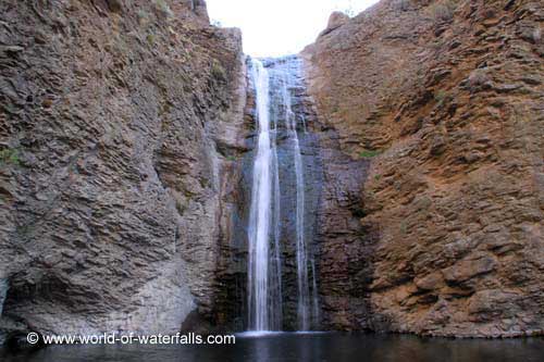
Jump Creek Falls, near Marsing
Big Jacks Creek canyon as it looks as you're hiking down from the Parker Trailhead. 
Hi all,

After a week of unsettled weather, this weekend looks fabulous with clear skies and temperatures in the mid-70s in the Treasure Valley. There's a 30 percent chance of thunderstorms on Sunday. We've seen that all week, and sometimes the storm happens, sometimes not!

My outdoor tip this week will focus on a couple of handy hikes close to home. But first, I wanted to mention this we are in the midst of Boise Bike Week, sponsored by the Treasure Valley Cycling Alliance. Tomorrow is national Bike to Work Day  So if you need a little extra motivation to get your bike lock and gear together for biking to work, there you go!!! Plus, a bunch of coffee shops are offering a free cup of coffee to people who ride to work ... so there's another boost for ya! See Boise Bike Week Facebook page for details.

Now to the hikes. First, a couple in the Boise Foothills:

Lupine going off big-time on the way to Central Ridge Trail and Bucktail Trail in Military Reserve this week. 
1. Jumpin' Jeepers Figure-8 Loop - 6.75 miles. Rated strenuous as a hike or run with moderate sections. Rated intermediate for biking. Hiking time, 2.5-3 hours; running time, 1:20; riding time, 1:10. This is one of my favorite rides in Military Reserve that connects to Shane's Trail. It's an equally nice run or hike. The name comes from the Boise Police Dept. shooting range at the end of Mountain Cove Road. The unexpected blast from a gun might cause you to jump out of your skin! Thank goodness the city finally moved the firing range! The flowers are still popping along the way ... I saw a field of arrowleaf balsomroot and purple lupine on Wednesday. To start, go to Fort Boise and then the main trailhead on Mountain Cove Road, after the sharp right-hand corner heading west. Take the Toll Road Trail #27A to #20 Ridge Crest and climb to the top of the hill. Turn right on Central Ridge Trail and climb at a moderate pace to Shane's Junction. Take Shane's #26A to the left, and climb to the top of Shane's. You've climbed 1,000 feet over 3+ miles. Give your puppy a drink and a snack. Descend Shane's for less than a mile, turn right on the Shane's Loop and return to the Central Ridge-Bucktail-Shane's jct. Take Bucktail downhill and enjoy the big GS turns as you wind across a big downhill on a large flat. Bucktail drops into the Central Ridge alternative trail. Go right and then left on that and it'll take you back to the trailhead. It's a great view of Idaho's Capital City as you cruise downhill on that sagebrush slope to the trailhead.

2. Camelsback - Kestrel-Crestline-Red Cliffs Loop - Distance: 5 miles. Rated moderate for hikers and runners. Rated intermediate for biking. Hiking time, 2-2.5 hours; Running time: 55 minutes; Biking time: 45 minutes. This is a popular loop with hikers, runners and bikers. Start at Camelsback Park off of Heron and 13th Street in North Boise. Head over to the trailhead in the east side of the park, and follow Owl's Roost Trail on the right by the ponds. Follow Owl's Roost to the Foothills Learning Center area. Turn right at the junction with Kestrel, and climb Kestrel to Crestline, it's about .6 miles of continuous climbing. Turn left onto Crestline, climb a short abrupt hill, and then watch for a left-hand junction with Red Cliffs in less than a half mile. Turn left onto Red Cliffs and enjoy a fun descent for over a mile back to Hulls Gulch. Follow Hulls back toward the Foothills Learning Center, cross 8th Street, and take Chickadee Ridge back to Camelsback Park.

Now, a couple hikes in the Owyhees:

3. Jump Creek Canyon, near Marsing - Follow this link to see a write up in the Nampa Press-Tribune about visiting Jump Creek Canyon. They used my Owyhee Canyonlands guide for reference and driving directions. Be forewarned that there is poison ivy on the trail to the falls. Watch your step and keep the kids close at hand through that small section as you approach the falls. Once you arrive at the BLM recreation site, you'll notice that you can explore some extensive trails above Jump Creek Falls. Give that a go if you're up for hiking a greater distance than the quarter-mile trail to the falls.

4. Big Jacks Creek, Parker Trailhead - Big Jacks Creek is a gorgeous canyon. Go see it and judge for yourself.
Driving map for Parker Trailhead
The hardest part of the whole trip, like many in the Owyhee Canyonlands, is finding the trailhead. A good 4WD vehicle or a high-clearance Subaru is recommended for the drive, once you hit the dirt roads.

How to get there: Take the freeway to Mountain Home. Take the first exit. Follow signs for Idaho State Highway 51 and Bruneau. After you reach Bruneau, take note of your odometer. Stay on Idaho 51 for approximately 25 miles. You'll be watching for a right-hand turn on a good dirt road, called the Wickahoney Road, just past milepost 45. The road is not signed, but it's a BLM public road.

Follow Wickahoney Road 4.9 miles to a T-junction by Wickahoney Creek. Turn right and go 2.8 miles to the Parker Trailhead. Park and hike from there.
Leo Hennessy follows the Parker Trail into the Big Jacks Wilderness

You'll follow a two-track road over to the rim of the canyon, walk over a barbed-wire fence via a wooden step-over gizmo, and descend into Big Jacks Creek. Take your time, take some photos and enjoy the scenery. There's a foot path going down into the canyon; it's marked by rock cairns along the way. Watch for snakes. They could be out.

Once at the bottom, you can explore a little and eat lunch by the campsite area. Return the way you came.
Beautiful campsite at the bottom of Big Jacks. 
----------------------------------------------------------
The BLM is hosting two events this weekend related to the 25th anniversary of the Morley Nelson Snake River Birds of Prey National Conservation Area.

1. Join in on a Naturalist Photo Safari of overlooked and underappreciated components of the NCA ecosystem. On Saturday, it's "Insect Day." On Sunday, there's a plant and geology hike in the canyon. RSVP to Cory Coffman at ccoffman@blm.gov. For the full event schedule, go here.

Have fun!
- SS

Thursday, April 28, 2016

Weekend weather looks perfect for exploring Bruneau Dunes, Bruneau Canyon & Big Jacks

Steve on top of the dunes. Wearing boots and gators to keep sand out of shoes.
Big Jacks Creek photographed from the Parker Trail
Bruneau Canyon upriver 
Bruneau River Canyon from the Overlook (courtesy VisitIdaho.org)
Hi all,

The weekend weather promises to be partly cloudy and relatively cool, with highs in the low 70s -- perfect for hiking in the Owyhees. Last week, I recommended Wildcat Canyon near Marsing. This week, I'm recommending three outings in the Owyhees near Bruneau, south of Mountain Home.

I'm recommending Bruneau Dunes State Park, the Bruneau Canyon overlook, and Big Jack's Creek, the Parker Trail. All of these destinations are knock-your-socks-off scenic with fun exploring opportunities and optional camping. All of these destinations are detailed in my guide, Owyhee Canyonlands: An Outdoor Adventure Guide,. which features 55 hikes and bike rides in the vast, 5-million-acre area south of the Treasure Valley. 

So let's get to it!
  • Bruneau Dunes State Park - Go visit North America's tallest single-structured dune, 470 feet high. It's easy to climb up there and cross the top sandy ridgeline of the dune, and check out the other smaller dunes in the area. There's also some fishing there at the park, and the camping at Bruneau Dunes is absolutely first-class with services. Distance: 3 mile loop. Travel time: 1-2 hours at a very leisurely pace. Bring the kids! Great place for them to play. Pack a lunch. Bring plenty of food and water. Trail map here. Buy a $10 state parks pass with your vehicle registration so you can get free entry into any of Idaho's state parks year-round. Awesome deal! How to get there: Take I-84 to Mountain Home. Take the first exit and go south on Idaho 51 towards Bruneau. Cross the Snake River and then turn left and follow signs to the park.
  • Bruneau Canyon Overlook - This is another family friendly adventure to go see the yawning Bruneau River Canyon, 18 miles south of the town of Bruneau. The canyon is 800 feet deep from the top of the rim down to the rushing river. It's super cool to check out the layer-cake like geology of the canyon. Multiple layers of volcanic basalt and rhyolite are exposed in the canyon. If you don't have a copy of "Roadside Geology of Idaho," I heartily recommend it. How to get there: Take I-84 to Mountain Home. Take the first exit and go south on Idaho 51 to Bruneau. Pick up any last-minute items at the market in town, then turn left on Hot Springs Road and follow that south of town. After 8.5 miles, go left on the Clover Creek-Three Creek Road, a good-quality gravel road. 15 miles south of Bruneau, you'll see a BLM sign on the right, indicating the turn for the overlook. You could self-support camp in that area. You also could hike or bike on the two-tracks next to the overlook.  
  • Big Jack's Creek, Parker Trail - Distance: 2.5 miles; rated moderate to strenuous. Travel time: 2 hours or more. Pack a lunch and make a day out of it! Big Jacks Creek is a gorgeous, vertical redrock canyon, carved out of rhyolite lava. The Parker Trail is a rare developed trail anywhere in the Owyhee Canyonlands where a person can follow a trail tread from the canyon rim to the creek-bottom. It's about 1.25 miles down to the bottom. You'll come to a nice rock outcropping 1 mile down the trail, a nice spot for a photograph. There's a sweet campsite at the bottom of the trail next to Big Jacks Creek. So this trip has backpacking and camping potential. 


    How to get there
    From Boise, take I-84 east to Mountain Home. Take the first exit. Follow signs for Idaho State Highway 51 and Bruneau. After you reach Bruneau, take note of your odometer. Stay on Idaho 51, going south, for approximately 27 miles. You'll be watching for a right-hand turn on a good dirt road, called the Wickahoney Road, just past milepost 45. The road is not signed, but it's a BLM public road. Follow the Wickahoney Road 4.9 miles to a T-junction by Wickahoney Creek. Turn right and go 2.8 miles to the Parker Trailhead. The road is rougher for the last 2.8 miles. Higher-clearance AWD recommended. 
Have a great weekend!
-SS  

Thursday, April 18, 2013

Go explore Big Jacks Creek canyon in Owyhee Wilderness; plus new full-color plant guide

Big Jacks Creek ... a hidden crack in the desert
Succor Creek State Park
Big Hart Creek Canyon
Hi all,

The weather looks dicy Friday, but much better Saturday afternoon and Sunday for a sunny hike in the desert. For my tip of the week, I'm recommending three primo family friendly hikes in the Owyhee Canyonlands:

Click on the links above to get the details and maps for each trip.

You'll notice that Leslie Gulch was not on the list. That's because about 90 people are heading there this weekend for a big campout and lots of hiking with the Idaho Outdoors Yahoo Group. If you're not part of that group, you might find the whole scene a little overcrowded. You make the call.

---------------------------------

The second thing I wanted to highlight this week is a new Backpack Guide to Idaho Range Plants by the University of Idaho Rangeland Center and the Idaho Rangeland Resource Commission. I bought one at a conference earlier this spring.

I like the full-color, 173-page guide because it provides a way to identify native grasses, including different types of bunchgrasses we see in the shrub-steppe ecosystem in the Boise Foothills, Snake River Plain and the Owyhee Canyonlands. It also details the kinds of native shrubs, forbs (wildflowers), and trees you'll find in the state of Idaho.

I've got several wildflower guides, but I've always wanted a plant guide that provides more detail about plants! You can buy one online at this web site for $15, plus shipping.

-----------------------------

The first of two used whitewater equipment sales coming up is happening this weekend at Alpenglow Mountainsport a.k.a. McU Sports Highlands store at the junction of Bogus Basin Road and Hill Road. The used equipment sale occurs from 9 a.m. to 4 p.m. on Saturday. If you're looking for a used kayak, raft, Stand-up Paddle Board, check it out!

The following weekend, the Idaho Whitewater Association is putting on a used equipment sale at Idaho River Sports. This sale is typically the biggest one in the local area, and it will have some great deals as well on kayaks, rafts, SUPs, canoes, clothing, and parts.

Have fun!
- SS