Thursday, June 3, 2021

My oh my it's hot! Five paddling destinations in SW Idaho to keep you cool

Middle Fork Payette River 


Middle Fork Boise (courtesy John Keys) 
Swirley Canyon on the South Fork Payette River is a good alternative to the Cabarton run.
Hi all,

It's been piping hot this week in the Boise Valley, but fortunately, the temps should moderate into the 80s by the weekend. It's too early to see triple-digit hotness in Boise! 
Nevertheless, people will be itching to go paddling, swimming, and cooling off to beat the heat, no doubt!

FYI - The Boise River won't be open for floating at Barber Park for a bit longer. Watch the Facebook page for the latest information.
For my outdoor tip of the week, I'm recommending five paddling trips that would be doable for folks who have inflatable kayaks, rafts, SUPs, sit-on-top hardshell kayaks or whatever craft might be suitable. Pick a stretch that suits your ability. 
FYI - I'm not recommending the Cabarton run on the North Fork of the Payettte River this weekend because the water level is still REALLY low.   
1. Float the Upper Payette River from the Tenmile trailhead area to Helende Campground, upstream of Lowman. The Payette River is still running strong; be sure you are dressed for a cold-water situation. This is a Class 2 flatwater run with rocks to dodge and small rapids. 5-mile trip. This section would be doable for experienced whitewater SUP paddlers. Do a road scout and see what you think.

2. Middle Fork Payette River - Float the Tie Creek section through the scenic valley north of Crouch. 8-mile run. Class 1. Rated Easy. Just have to keep your boat in the current and stay off the brush on the riverbank. Put-in by Tie Creek Campground. There's a sweet takeout by the village of Crouch by the river. Plant a shuttle vehicle there before you go.     
3. Drive up to Arrowrock Reservoir, find a spot to hang out by the water, put up your sun tarp, and go paddling in the reservoir. A good truck works great for driving down to the reservoir's edge, and there are some camping spots along the Middle Fork road. Take ID 21 to the Spring Shores/Middle Fork Road and drive up-canyon to Arrowrock and find your spot from there. Any flatwater craft would work on Arrowrock, plus motorboats of course.

4. Drive up the Middle Fork Road past Arrowrock to Troutdale Campground or any other spot of your choosing, and float the lower section of the Middle Fork Boise River. This is a mostly Class 2 flatwater run with rocks to dodge and small rapids. A group of people I know ran this section last week and had enough water flow (450 cfs today) to make it through in hard-shell kayaks and inflatable kayaks. Strong SUP paddlers might want to try it. 
5. North Fork Payette River from McCall to Hartsell Bridge. 9-mile trip. Allow a full day. The float goes through the northern half of Long Valley, coursing through a million S-turns through the scenic valley. Potential for fishing, too. Put-in is at Sheep Bridge off of Mission in McCall, and takeout is at Hartsell Bridge, accessed from Smylie Lane. Be sure to plant a shuttle vehicle there. I've done the bike shuttle, and it's a long one!
Blackadar Rapids in the South Fork Canyon (courtesy Cascade Raft & Kayak) 

Another option if you don't have your own gear, go with a pro! Sample all of the fun whitewater trips on the Payette River, including the South Fork "Staircase" run, the South Fork Canyon, Main Payette and Cabarton.
 Cascade Raft & Kayak, Bear Valley Outfitters and Idaho Whitewater Unlimited all offer guided rafting adventures on the Payette River. Schedule a trip for your family and friends and have a blast!  
There you have it! 
FYI - The North Fork Championships are back! June 17-19. 
Have fun! 
- SS 

Thursday, May 27, 2021

10 last-minute ideas for Memorial Day getaways in Idaho

Wendy in the White Clouds

Hi all, 

Memorial Day weekend is upon us, and if last year is any indication, it's going to be busy out there! 

Last week, I provided numerous trip-planning resources for deciding where to go in advance. Be sure you have a Plan B, Plan C and Plan D because the campsite you planned on snagging may be taken! 

So here are some suggestions on where to go: 

Snake River canyon singletrack

  • Camping in the Owyhees should be excellent. Watch your step ... rattlesnakes may be emerging. Places like Leslie GulchSuccor Creek State Park or the Morley Nelson Snake River Birds of Prey National Conservation Area would all be good bets. Be sure to take my Owyhee Canyonlands guide with you for tips on hiking and biking near your camping destinations. 
  • Bogus Basin Mountain Recreation Area is opening this weekend. Around the Mountain trail is still snow-covered in places and is not open yet. But there are other trails to explore close to the base area, and the mountain coaster is open. And it'd be a fun place to go and hang out! Trails to Stack Rock and Eastside are open.
  • Morel mushrooms are popping in the Boise and Payette national forests. Morels are delicious and easy to identify. The tricky part is where to find them! I was finding shrooms in the 5,000-foot range in the greater Valley County area last weekend. Any fresh burn areas can be excellent. See a recent blog post on morel-picking in burn zones.  
    Genuine Idaho morels

  • Go fishing! Memorial Day is the annual kickoff to the summer fishing season. Many reservoirs, ponds and river sections have been freshly stocked. See the IDFG Fishing Planner to discover where to go fishing.
  • Go car-camping on the North Fork or Middle Fork of the Boise River. Check on road conditions with the Idaho City Ranger District. See list of campgrounds that are open in the Boise National Forest. You can look for dispersed camping sites along the Middle Fork of the Boise River, driving up along Lucky Peak and Arrowrock and continuing upstream toward Atlanta. Do the self-support camping trip and pick your own spot.
  • Go camping in the national forest. Look for low-elevation sites in the Boise, Payette or Sawtooth National Forest ... see the interactive map for more information.
  • Salmon River beaches! A great spring camping location is on the sweet white sandy beaches along the Salmon River, upstream of Riggins. Get there early! It's popular! There are numerous big beaches up there where you can set up a great camp, hang out by the river, do some floating on the Salmon and/or go hiking. Use caution around the Salmon River! The hike on the Wind River Trail via the Wind River Pack Bridge about 25 miles upstream of Riggins has a number of switchbacks as you climb higher and higher up the Salmon River canyon. That'd be a great hike right now. Rapid River Trail is great in Riggins, too.
  • Take a day hike in the Snake River canyon or in the front side of the Owyhees ... See my Owyhee Canyonlands guide, available at most outdoor stores and book stores. I'd recommend Little Jacks Creek, the West Fork Shoofly Quick Loop, Between the Creeks, Toy Pass hikes, Reynolds Creek, Wilson Creek, Jump Creek Canyon or Wildcat Canyon. Google any of those hikes and rides; I've blogged about all of them. Watch for snakes.
  • Head up to the Lochsa River and go rafting on the biggest whitewater weekend of the year on the Lochsa.  
    Route of the Hiawatha inside the Taft Tunnel (Courtesy Lookout Pass)

  • Ride the Route of the Hiawatha in Wallace. It's opening Friday. Highly recommend it! Family friendly!  
  • Stay home and hike/ride/run in the Boise Foothills - It's super green, the wildflowers are out, and the trails are in great shape. Boise Ridge should be clearing of snow now.
  • Stay close to home and go for a road bike ride. See my Boise Road Cycling Guide for ideas. 
  • Stay close to home and check out the Memorial Day sales at your favorite local outdoor stores. There are usually some great deals to be had, at up to 50% discounts! 
There you have it! Have a great weekend no matter what you do!
 
While you're out there, be sure to Recreate Responsibly, be a good steward, practice leave-no-trace camping principles, etc. Thank you.

-SS

Thursday, May 20, 2021

2021 camping season is kicking into gear on National Forest lands! 8 Tips on best camping practices

Camping season is upon us!

Hi all, 

It's been a great spring for camping in the Owyhee Canyonlands and BLM lands and river sites in SW Idaho. Now that the snow has melted out in the lower elevations in the Boise, Payette and Sawtooth National Forests, Forest Service officials are opening numerous campgrounds this weekend (May 21-23) and next for the traditional camping opener over the Memorial Day long weekend coming up May 28-31.  

The weather actually looks quite rainy and cold in McCall and Stanley this weekend, but the weather looks more promising for Memorial Day weekend, so perhaps you can plan your next outing and pick a fun spot for friends and family.

The Boise National Forest just released a list of campground opening dates online. The Payette National Forest also has opening dates here. The Sawtooth National Forest camping link is here with opening dates. Generally, camp sites at low to mid-elevation are open now, and higher-elevation sites in Stanley and the Sawtooth Valley will be opening soon. 

Check out this new statewide Forest Service interactive map! It's a handy resource for locating campgrounds and other national forest amenities.

Many Idaho State Park campgrounds are open now and will be soon. See this link for information on reserving a campsite an Idaho state park. Local favorites include Three Island State Park, Bruneau Dunes State Park, Lake Cascade State Park and Ponderosa State Park. See the IDPR web site for more information. 

Research BLM campsites here. There are many hidden jewels on BLM lands.

So it's time to plan a trip! Pull all the camping stuff together, tents and sleeping bags, food, water, clothes, etc. Or perhaps you have everything packed in an RV? Research a campsite that provides the kinds of amenities you want such as hiking or biking trails nearby or water hookups? Fishing? River or stream access? Grand views? There are literally hundreds of camping locations to enjoy in Idaho. 

What kind of setting do you want for your camping experience?

Tip #1 - Know where to go. Research where you're going to go camping before you go. Make a reservation online, if necessary, and you'll have your trip dialed in. If you're going to pursue a campsite in a campground where no reservations are necessary, go early to get your spot. 

Tip #2 - Make a Plan B. Your favorite campsite might be taken or the campground could be full. You'll need an alternative plan if things get busy. If last year is any indication, it's going to be a busy summer with major competition for campsites in Idaho. Going mid-week or in off-peak times will be a great way to avoid the crowds.

Tip #3 = Make a Plan C. Plan B might be taken too. 

Tip #4 - Remember to Pack-it-in/Pack-it-out. Bring your own garbage bags and pack out your garbage. Many public lands camping areas have no dumpsters or trash service. 

Tip #5 - Leave no Trace. Leave a clean campground when you leave. Pack out all of your things and garbage and make sure you haven't left any micro-trash on site ... things like small wrappers or twist-ties or what not. 

Tip #6 - Snuff out your campfire completely before you leave. Pour water on the fire and make sure you don't leave hot coals behind. More than 80% of the wildfires in Idaho are typically caused by humans. 

Tip #7 - When nature calls, dispose of human waste properly. Use the outhouse or dig a cat-hole and bury your waste. Bring a little shovel for digging a proper hole. Walk 200 feet away from any water sources. See video for more detail.


Tip #8 - Bring your own firewood. There might not be much firewood available at your camping spot, depending on location. 

Thanks to Tread Lightly and the Boise National Forest for the videos!

Have fun out there!
- SS

Thursday, May 13, 2021

Station Creek, Cottonwood Creek National Forest hikes are tailor-made for a warm weekend in Boise


Wendy and Huck enjoy the view on top of the first ridge on the Station Creek Trail.

Hi all, 

It appears we're in for a bit of a heat wave this weekend, comparably speaking, with high temperatures in the low to mid-80s Friday-Sunday in the Boise Valley. It'll be in the 60s and 70s in the mountains around McCall, Stanley and Sun Valley.

Getting out early on Boise Foothills trails will be the charm this weekend, or heading to slightly higher elevations would be a good idea, too! 

To that point, I'm recommending two hikes in the Boise National Forest -- Station Creek and Cottonwood Creek -- for my outdoor tip of the week, plus I'll recommend a few other destinations that'd be perfect right now (below). 

Station Creek Hike

Station Creek Trail is a beauty, coarsing through a continuous layer of green on the forest floor, while stately ponderosa pine trees provide shade in the canopy overhead as you're climbing the mountain. Arrowleaf balsamroot is blooming in bright yellow along the way. It's a 7-mile out-and-back hike to the top of Bald Mountain, or roughly 5 miles out and back if you hike to the first ridge overlook. Hiking time: 3-5 hours round-trip. Rated: Moderate (strenuous in a few places)

If you go to the top of 5,122-foot Bald Mountain, you'll climb 2,000 vertical feet along the way. That's a very reasonable climb for most people who are in decent shape. Just take your time, breathe, and enjoy the scenery!

The trailhead is located directly across the Banks-Lowman Highway from the Garden Valley Ranger Station - hence the name, Station Creek! 

The well-maintained trail will take you to the top of the first ridge, and then there is a more faint elk trail that follows the lay of the land to the top of Bald Mountain. It's easy to find your way. 

Be sure to pack plenty of water and bring a lunch/snacks for the summit!


Steve and Huck on top of Bald Mountain with its trademark weird thingy on top.

Wendy enjoys the walk on a classic ponderosa pine ridge.

Bald Mountain, just shy of a mile-high ... good early-season hike

Cottonwood Creek 

Prior to some wildfires that swept through the Cottonwood Creek drainage, the Cottonwood Creek trail used to be quite the gem. It had a million creek crossings, but in between, it was much like Station Creek. Since the fires, the trail has gotten more brushy and falling into disrepair. Nevertheless, the first several miles are doable. But the full enchilada, which is more like 10 miles to the top of Thorn Butte, is not recommended. 

Still, if you haven't been up along Arrowrock Reservoir to the Cottonwood Creek Trailhead, it's worth the trip just to check out the countryside. 

Directions: Take Idaho 21 to the high bridge over Lucky Peak and turn right. Go about 15 miles along Lucky Peak and Arrowrock reservoirs to a junction with USFS Road #377. Go left and follow the road 3 miles to the Cottonwood Creek trailhead. There's a small parking area there. 

Possible side trip: In this area, you're close to the Mount Heinen trailhead, if you're feeling more ambitious and want to tackle a challenging 10-mile climb to the Heinen summit. See my post about this hike, it's one of the four Boise Grand Slam Peaks

Cottonwood Creek guard station

Beaver pond on Cottonwood Creek

Some other recommendations ... 

  • Any of the Boise Grand Slam peaks would be great right now. 
  • 80 degrees means it's time to get tuned up on the river! Middle Fork Payette, South Fork Payette and Main Payette would be great right now. I noticed that Cabarton is only running about 650 cfs. Mid-summer flows are usually 1500-1800 cfs. 
  • Salmon River is running 20,000 cfs at Whitebird ... if it's going to come up any higher, that might happen this weekend with the warmer temps. But not much of a peak!
  • Go past the Cottonwood Creek turnoff on the Arrowrock/Middle Fork Road and continue up to the Sheep Creek trail. That's a great hike, just quite the drive to get there. 

FYI - Steve and Mike Cooley, recently retired from George's Cycles, will appear on the KTVB-TV Viewpoint program on Sunday, talking about road biking and mountain biking in the early days of Boise becoming a bike town. 

Have fun!
- SS

Thursday, April 29, 2021

Just when you're feeling cocky on the bike, try these 5 tough climbs to test your legs and lungs!

Stueby's Death March with Chris and Quinn (after they've caught their breath)

Hi all, 

We're all loving the spring hiking, running and riding conditions right now, with wildflowers bursting with color in the lower portion of the Boise foothills and the head-high bitterbrush blooming and casting an ever-sweet aroma all around the trails. 

I've been trying to ride several times a week on my mountain bike, weather permitting, and I've been feeling pretty comfortable with mid-foothills rides lately. So today, I thought I'd crank it up a notch and do the upper part of Stueby's Death March (from Mountain Biking in Boise) from the Fat Tire Traverse junction over to Trail #4. 

My original plan was to ride Crestline-Sidewinder-Fat Tire-Trail #5 loop, approaching from the Military Reserve side, so starting the ride with that nasty little connector trail that climbs from Military Reserve to Crestline. I felt good on the climb to Sidewinder and the cross-mountain cruise on Fat Tire Traverse over to the Trail #5 ridge, so I turned left and decided to go for it! 

This is how you really feel after that gut-buster climb.

For those unfamiliar, Stueby's Death March typically started in Military Reserve and you climb the super-steep Trail #5 from the bottom. But it's nicer to approach from Sidewinder and Fat Tire Traverse. Bless you if you can clean that first, nasty Trail #5 hill. Anyway, to complete the Death March, you continue climbing Trail #5 above the Fat Tire jct., clean a couple of reasonable hills, and bear left at the jct. with Fimrite's Trail #6. Now you're going to climb 300 yards on a gravely slippery rocky sandy trail over to Trail #4. It's hard enough that it's quite steep, and then slippery to boot! Gotta stay on your line while you're gasping for air! 

Today, I managed to clean that baby without spinning out or falling off my line. It was a gorgeous day, and I was feeling strong and focused. So that was my little victory for the day. And then the payoff is a fun swishy downhill on Trail #4 back to Sidewinder, and then pick your way down from there. Fast and fun! I took Trail #4 down to Crestline and cruised on the Freeway back to the Military Reserve connector trail, and finished out my loop ride in about two hours total. 

The ride features about 2,000 feet of vertical gain. About 12+ miles the way I rode it today. 

Stueby's Death March map

 Some other challenging rides in the Boise Foothills that will test your legs and lungs include: 

  • Climbing Hard Guy to the Boise Ridge Road
  • Scaling the south side of Table Rock (junior training hill)
  • Ride up Hulls from Camelsback to the motorcycle parking lot, ride over to Bob's and climb Corral's backwards, finishing out on Corrals and Highlands Trail.
  • Homestead Trail over to Trail #11 and back to Council Springs trailhead 
  • Highlands-Corrals-Scott's-8th Street then down on Trail #4 or down Hard Guy, Shingle or Dry Creek

If you'd like to see more classics out of my library, my last version of Mountain Biking in Boise is available via ebook on stevestuebner.com.

Cool jumble of granite rocks in the eastern Boise Foothills near Trail #11

Remember to follow the new trail regulations in the Boise Foothills, featuring one-way trails. It's all detailed on the Ridge to Rivers web site.

Thursday, April 22, 2021

The Grand Ronde River rocks as a springtime alternative to the Owyhee River

Steve Schneider, left, and Jim Giuffre soak up the scenery of the Grand Ronde River canyon.

Hi all, 

I watched the weather and the Owyhee River flows like a hawk in March and early April, and dang, the Owyhee was amazingly elusive this year! The flows rose a bit when it started to warm up, and then it'd crash with major cool-downs, rise again a bit, and then suddenly, it was gone, well below 1,000 cubic feet per second, a minimum level for rafting. 

On the heels of the ski season, I had a major itch to get out on a spring river and go camping for at least a couple of nights. I normally head over to run the Grand Ronde River in May, but last week, I saw the flow was running over 5,000 cubic feet per second. Bingo! I made a few calls, pulled together a great little group of friends -- friends who also have their own boats and gear -- and we made plans on launch on Sunday, April 18 and takeout on Wednesday, April 21. 
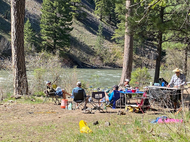
Our layover camp

A 4-day trip would allow enough time for a layover day at one of my favorite campsites that often features bighorn sheep and an excellent ridge hike to a spectacular viewpoint on top of the 1,000-foot-deep canyon. 

Plus, the river rose to 6,500 cfs while we were on the trip, making it super easy to make miles when needed. At some points, we were averaging 7-8 mph floating downriver on Day 4. Yee-haw! 

Overall, the Grand Ronde River trip is a 38-mile scenic jewel. Put-in is at Minam State Park east of Elgin and La Grande, and the takeout is at Powatka Bridge. The Minam Store by the river-launch site will run your shuttle for $125/vehicle. A self-issue BLM permit can be filled out before you launch. 

Paved roads to the put-in. I like how you can drive the freeway and paved highways from Boise to the Minam launch in about 3.5-4 hours via La Grande. 

Looking down at rock cliffs on a hike above camp.

Floating the Grand Ronde is kind of like going home for me, as I lived in La Grande in my first newspaper job out of college for three years to start my journalism career. I loved living in La Grande. It was also the first river where I learned to row a raft. It's a good beginner river, with mainly Class 2 rapids. The Grand Ronde River draws from the snow in the mountains above La Grande as well as the Wallowa Mountain range and Eagle Cap Wilderness. 

My friends thought the river was similar to the Middle Fork in the section, say, below Indian Creek, without as many rapids. And I agree. It's an official National Wild and Scenic River. The top portion of the Grand Ronde canyon is designated as a Wild river, and the bottom, below Powatka Bridge, is Recreational. The upper canyon has dozens of beautiful forested campsites, where you can spend more than one night, if you wish. 

Steep hike to the ridge out of camp

If you go, be sure to practice the same pack-it-in/pack-it-out camping practices that you observe on Idaho's permitted rivers -- things like burn your fire in a firepan, pack a toilet for human waste, and leave nothing behind when you leave camp. 

On this particular trip, I enjoyed having my good ski and biking buddies Steve Schneider and Jim Giuffre in the bow of my raft. We have been having a blast shredding powder in McCall all winter long. Now the calendar is turning to mountain biking and rafting! 

We also had Dan Popkey on the trip, a former Statesman political columnist and reporter with whom I used to float lots of rivers back in the late 1980s and early 1990s. It was fun to do a trip with Dan again, and it was also special to have Rocky Barker with us, too, on Dan's raft. Rocky and I have done a lot of trips together and worked together as journalists on projects dating back to the 1990s.  

Eric strikes a pose on top of the ridge

Friends Eric Straubhar and Kirk Bachman rounded out our crew. Eric and Kirk and I have done a number of Middle Fork trips and other trips together in recent years. But they'd never done the Grand Ronde. We all have the gear needed for a river trip, so it's pretty easy to put a trip together. Those guys are awesome hands on the river or anything outdoors for that matter. 

We had chilly mornings and sunny afternoons. It was key to bring plenty of firewood for warming fires in the morning and evening. Both of the camps we stayed at had plenty of surplus wood, just behind camp, too.

Just a lovely afternoon on top of the ridge ... barely a whisper of wind

Other spring rivers
: As things warm up, the Payette River and Salmon River will be great choices moving forward. The Lower Salmon will be doable as long as it's below 20,000 cfs at The Slide (dangerous rapids above that level). The South Fork and Main Fork of the Payette are starting to come up, and the North Fork will be running soon. See Idaho river flows USGS site for real-time flows. 

The Riggins day stretch or Vinegar Creek to Spring Bar are several other good spring river trips. And the mighty Lochsa should be cranking big-time with the best snowpack in the state. Looks like it's already running close to 5,000 cfs this week.

Iphone doesn't do it justice, but these rams were impressive!

Hells Canyon and the Hagerman section of the Snake River are a couple of other spring river options. This is still pre-permit season in Hells Canyon BTW.
- SS    

Thursday, April 15, 2021

Final weekend at Bogus, new R2R trail regulations in the Boise footies and sheep!

Lower Hulls Gulch will be switching to odd/even day management on April 28.
See below for details.

Hi all, 

We've got another fabulous bluebird weekend weather coming to the Boise Valley and beyond this weekend, with high temperatures in the high 60s to low 70s and no chance of rain. It'll be a great weekend to do just about anything outdoors!

For my outdoor tip of the week, I'm highlighting and recommending three things:
  • Final bonus weekend at Bogus Basin for season pass holders and anyone else who wants to go! Hours of operation are 9 a.m. to 4:30 p.m. Here's an online link for a lift ticket, if you don't have a season pass. Should be fab soft snow by late morning. Follow the mountain around to the north if you feel the snow is too soft on other aspects. Dress up and have fun!
  • Watch the sheep crossing on Idaho 55 at Beacon Light on Saturday morning. The sheep should be crossing at approximately 9:30 a.m. Please be respectful and stay to the side of the road during the sheep drive and take pictures.  
    • Remember to leash your dogs if you encounter sheep on the Boise Foothills trails. Also if you ride into sheep, dismount from your bike and walk through the sheep herds. 
  • Steve's take on the new 2021 pilot project/trail regulations coming later this month for R2R trails in the Boise Foothills and Around the Mountain at Bogus Basin. 

On Wednesday afternoon, I rode the Polecat Loop counter-clockwise to practice for the new regs kicking into gear on Wednesday, April 28. They will be in effect through Nov. 1. Print this out and post it on your fridge so you have a handy reference to remember how this is going to work moving forward.

The 2021 pilot management strategies are being implemented with a focus on directional and separation of use opportunities, according to the City of Boise. 

Bucktail Trail will become a downhill one-way trail on April 28.

“Use has tripled on Ridge to Rivers trails since the COVID-19 pandemic began, and we are interested to see how these management strategies provide the experience in the foothills users of all kinds want to see,” said Doug Holloway, Boise Parks and Recreation director. “We appreciate everyone’s patience as we test these new strategies, and we will continue to listen to users as we work to meet the needs of our growing recreation community.”

My take on the pilot project is that it's worth trying this year to see how it works with all-time record-high recreation use happening on our trails. I think it makes sense to separate use when possible, and one-way trails should lead to less conflicts. 

That said, try to be a good trail ambassador when you're out hiking, running or biking. Take the Happy Trails pledge on the R2R web site, be friendly and courteous to your fellow trail users when you're out on the trails, and just chill out a bit when you're out on the trails. Remember that we're blessed with an awesome trail system. We're all in this together. 

I will add that trail etiquette and promoting responsible, shared use of trails in the Boise Foothills have been super important since we started to see increased use in the 1990s. As the founding president of SWIMBA, our first course of action in 1992 was to support the creation of the R2R trail system, and a promote responsible, shared use of trails with new riders. I preached it in all of my Mountain Biking in Boise guidebooks. Our advice in general was to slow down and yield to hikers/walkers on the trails when you pass by. That's still my advice. 

Here are the details of the new regs, courtesy of R2R: 

  • Lower Hulls Gulch Trail #29 – On even numbered days of the month, the trail is closed to all downhill bike travel (open to hikers and equestrians to travel in both directions and open to uphill mountain bikers) for the duration of the pilot. On odd numbered days of the month, the trail is only open to downhill bike traffic (closed to all other users) for the duration of the pilot. Don't go hiking uphill on Hulls on odd days!
  • Polecat Loop Trail #81 – All trail users are required to travel one direction (counter-clockwise) throughout the duration of the pilot. The first half-mile of the trail from the Polecat Trailhead on Collister Drive will remain multi-directional to provide an out-and-back experience at Polecat Reserve.
  • Around the Mountain Trail #98 – All trail users are required to travel one direction (counter-clockwise) throughout the duration of the pilot. This trail is jointly managed by Ridge to Rivers and Bogus Basin.
  • Bucktail Trail #20A – A new pedestrian-only trail will be constructed between Central Ridge and Bucktail Trail. The existing Bucktail Trail will be modified and open to downhill mountain bike travel only. Uphill mountain bike access will be via Central Ridge Trail. 

The management strategies outlined above received support from a majority of users who participated in the Ridge to Rivers 2021 trail user surveys.

Ridge to Rivers and Bogus Basin staff will be adding new signage throughout the trail system in 2021 and the pilot program is expected to formally start on Wednesday, April 28. Trail rangers and Ridge to Rivers team members will focus on visiting the four trails included in the pilot program to educate users about changes, and to answer any questions. 

Please be mindful of and courteous to all users as these pilot management strategies are implemented. 

Buena Vista trail. Cool and scenic spot.

BTW - I did a quick bike ride in the Hillside to the Hollow area yesterday afternoon, and the whole south-facing hillside along the Buena Vista Trail was lit up with bouquets of arrowleaf balsomroot. Nice place to go hiking, running or biking with big views of the city of Boise. 

Have a great weekend!
- SS