Showing posts with label Stack Rock. Show all posts

Thursday, October 1, 2020

Five fall hikes in SW Idaho that really shine this time of year!

Charcoal Gulch, Boise National Forest (courtesy Visit Idaho) 

Hi all, 

When I see beautiful bluebird days like we've been having lately, I start yearning to visit Silver City in the Owyhees, upper Dry Creek in the Boise Foothills, Charcoal Gulch in Idaho City, and some of my favorite trails around McCall. 

For my outdoor tip this week, I'll recommend five fall hikes below. All of these hikes are in my two hiking guides, Boise Trail Guide: 95 Hiking and Running Routes Close to Home or Owyhee Canyonlands - An Outdoor Adventure Guide. 

The weather looks absolutely stellar for the next 7-10 days in the Boise area and Central Idaho! Cool nights -- freezing cold in the high-mountain elevations -- warm afternoons in the 70s and low 80s, and comfortable evenings while it's still light. Nothing better! 

Before you go, for fall hiking, remember to pack a few more things such as a good rain/wind coat, a few extra upper layers, a good hat, skull cap? water, snacks and camera (your phone) and hiking poles. 

The Mountain Coaster! (Courtesy Bogus Basin) 
And now, for the hikes: 

1. Bogus Basin Mountain Recreation Area - It's the last weekend at Bogus where they'll be operating lifts, food and beverage. You can hike Deer Point to Elk Meadows and do a 5-mile around the hike or do the full 10-mile Around the Mountain hike, or something less or more. 

2. Charcoal Gulch, Idaho City - Take a drive to Idaho City and go for a nice colorful hike on the Charcoal Gulch Trail, just on the outskirts of town. Find the trail by the Idaho City Airport (ever been there?) on the south side of town. There's a little trailhead on the north side of the airport. Take the Buena Vista Trail along the edge of the mountain, and then you'll see the junction for Charcoal Gulch. There are aspens and pines along the way, plus a small creek.  

Silver City 

3. Silver City Sawpit Mountain Loop - It's an 8-5-mile loop that circumnavigates a timbered mountain with a bald pointy cap that looms over Silver City in the high-elevation community in the Owyhees. It's rated moderate to strenuous. The fall colors in Silver City should be starting to happen anytime! I wrote about this hike last fall for Idaho Press Outdoors. Please see my story for directions and details. 

4. Freddy's Stack Rock Trail - Stack Rock is a signature granite pyramid-shaped rock on a timbered ridge to the west of Bogus Basin Mountain Resort. It's a 9.5-mile hike or bike ride from the trailhead to do the loop around Freddy's Stack Rock Trail. I would rate the hike/ride as moderate to strenuous because of a number of continuous uphills along the way, the distance and 2,600-vertical-foot gain/loss. You're walking/riding in the pines throughout the route, except when you get to Stack Rock, so that makes it scenic and intimate. Take a lunch to enjoy on Stack Rock. 
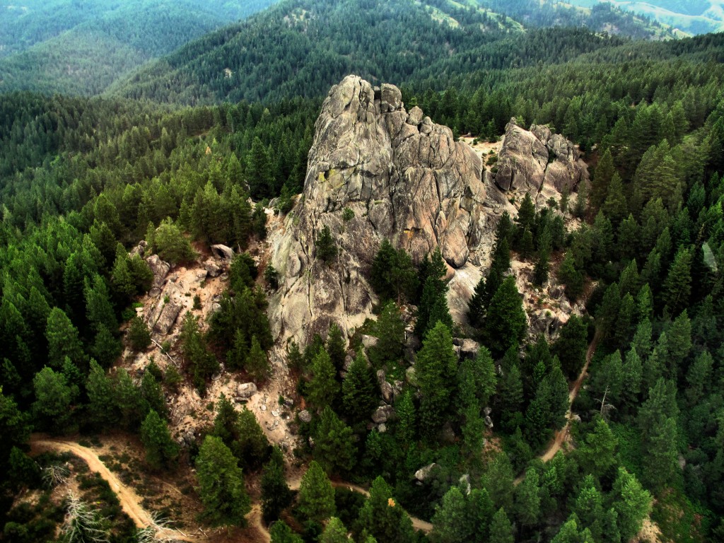
Image result for stack rock
Photo courtesy of Tom Lopez


Backstory: Approximately 1,300 acres of the Stack Rock area came into public ownership courtesy of a $1 million donation by Boise resident Fred Alleman and additional funds from the Boise Foothills Levy Committee. The land was purchased from the Terteling family in December 2009 for $1.32 million to make it available for public use. 

Directions: Park in the Forest Service parking lot and take the new trail over to Stock Rock/Sweet Connie junction to get started. Watch for the big parking lot on the right about Mile 12. 

You'll see a number of nifty bridges on the Dry Creek Trail ... keeping your feet dry.

5. Dry Creek out and back, Boise Foothills - Dry Creek is always a pretty hike, but especially right now, it should be great. The trailhead is off of Bogus Basin Road, several miles up from Boise, on the right side, as the road begins a series of hairpin switchbacks. You'll see other cars at the trailhead. It's a big day to hike to the top of the Boise Ridge via Dry Creek (7.5 miles, 2000+ vertical feet), so just take your time and go as far as you want. 


Have fun!
- SS 

Thursday, November 7, 2019

New trail to Sweet Connie, Stack Rock provides plenty of entertainment

L-R, Doug Lawrence, Steve, Jim Young and Mack Lyons on Stack Rock. 
The new trail to Stack Rock has a number of open vistas on the sunny side of the ridge. Nice for cold-weather conditions.
Hi all,

Several of my mountain bike buddies and I rode the new trail over to Stack Rock last week, and we thought it was a blast!

The new trail provides long-term public access over to Sweet Connie junction, and it takes you on a loop around Stack Rock.

Total trip mileage was 12.3 miles to do the loop around Stack Rock. Vertical gain was 1,107 feet, but it seemed like more than that. Travel time was more than 2 hours with several stops along the way for photo ops at Stack Rock, and lunch at Sweet Connie.

Tracks from Bogus Basin Road. 
I would rate the ride strong intermediate, moderate to strenuous in terms of difficulty.

The new Forest Service trailhead is closed for the season, but you can still access the trail by riding your bike from a right-side pullout along Bogus Basin Road, or from parking elsewhere and riding from the top of the trail.

David Gordon, Ridge to Rivers trail coordinator, laid out the new trail. Thanks Dave! Nice work! And a trail construction crew, Cuddy Mountain Trails out of Cambridge, Idaho, did the trail construction. Ridge to Rivers handled all construction contract oversight.

The new trail is slightly downhill on the way over to Sweet Connie junction, and it's slightly uphill on the way back. There are a number of entertaining features where you thread through some granite pillars and that sort of thing. It's a great trail for hiking, biking and trail-running, and it's open to horseback riding as well.

My GPS didn't capture the full mileage because of tree cover, stops or something ... it's more like 12.3 miles. 
It's a quick 3 miles or so over to Sweet Connie junction, and then you can decide if you'd like to ride counter-clockwise or clockwise on the lolly-pop loop around Stack Rock. We did it clockwise, which means you're going to climb a very strenuous granny-gear pitch in the approach to Stack Rock. But it's super fun the rest of the way. Both ways are doable.

I have a feeling that the new trail is going to make the Sweet Connie descent to the Bogus Basin trailhead, Peggy's Trail or Hidden Springs even more popular in the future.

Enjoy!
- SS


Wednesday, August 24, 2011

Check out Freddy's Stack Rock Loop Trail near Bogus Basin, if you haven't already

Stack Rock, a signature landmark near Bogus Basin

Google Earth GPS map of the ride
Topo GPS tracks of the ride
The ride has 2,600 feet of gain ... lots of up and down
Hi all,

With these hot, dog days of August weather, it's best to cool off in the lakes and rivers, or go hiking and biking on high elevation trails.

This week's tip is about the new loop trail around Stack Rock called Freddy's Stack Rock Trail. Stack Rock is a signature granite pyramid-shaped rock on a timbered ridge to the west of Bogus Basin Mountain Resort. Approximately 1,300 acres of the Stack Rock area recently came into public ownership courtesy of a $1 million donation by Boise resident Fred Alleman and additional funds from the Boise Foothills Levy Committee. The land was purchased from the Terteling family in December 2009 for $1.32 million to make it available for public use.

The City of Boise has placed a rock at the trailhead with a message about the land-preservation effort to let the public know how the purchase was made possible. THANK YOU FRED ALLEMAN!


Since that time, the Ridge to Rivers Trail Program built a loop trail around Stack Rock. It's called Freddy's Stack Rock Trail. Here's the Ridge to Rivers trail map of the route, Trail #125. Judging from how well-used and buffed the trail was on Tuesday, I'm guessing that a lot of people have been sampling the new trail and love it!

"Awesome trail!" a mountain bike rider exclaimed as he came into the parking area/trailhead off of Bogus Basin Road soon after I arrived. The parking area is 12 miles from the stop sign at Curling Drive and Highlands Elementary School.

It's a 9.5-mile hike or bike ride from the trailhead to do the loop around Freddy's Stack Rock Trail. I would rate the bike ride as advanced intermediate because of a number of fairly steep continuous climbs along the way, and I'd rate the hike or trail run as moderate to strenuous because of the distance and 2,600-vertical-foot gain/loss.

Just so you know: The trailhead is not marked. It's a major pullout on the left as you're heading to Bogus Basin after the road passes the turnoff to a number of cabins on the left. Just set your odometer when you leave the stop sign at Curling Drive, and you'll find it, no problem. Mile 12.

I checked in with Fred Alleman on Wednesday to see how he likes the trail. He said he's been up there a bunch, either biking or hiking it. "I like it," he says. "I think Ridge to Rivers has done a great job with the trail."

I agree. Stack Rock was a stealth destination for years, but we had no official access, and the area could have been lost to development forever if the city and Fred Alleman hadn't stepped up to protect it for perpetuity.

You should allow 2+ hours for the biking loop, and 4-5 hours for hiking the loop. Be careful when you're climbing around Stack Rock. "Going up is the easy part," Alleman notes. "It's getting down that's hard."

Have fun!
- SS