 |
| Fresh *pow* at Brundage Mountain Resort |
Hi all,
The first big snowstorm of the fall is coming this weekend, and that could put at least the Idaho Mountains into winter mode for the upcoming ski season. Deer and elk hunters also will be rejoicing to see the snow potentially move big game animals down to lower elevations and provide the ability to track their movements in the snow.
This winter is forecast to be the third La Nina winter in a row or a "Triple Dip La Nina."
 |
| La Nina winter weather pattern map (courtesy NOAA) |
What does that mean for Idaho?
In general, La Nina winters favor more precipitation in the Pacific Northwest and the Northern Rockies. But certainly the last two La Nina winters were not all that impressive, at least in Southern Idaho, the Sun Valley area, and the Upper Snake River watershed around Yellowstone National Park and Jackson Hole, Wyo.
A late, wet spring saved us after watching the mountain snowpack flatline between mid-January and the end of March. But now, many of Idaho's irrigation reservoirs across the Snake River Plain are close to empty or dry, so we will need a big winter to replenish our water supplies in Southern Idaho.
How much snowfall is coming this weekend?
The first burst of the storm system is forecast to bring 10" or more of new snow to Northern Idaho, 4-6 inches in McCall, Tamarack and Stanley, and 1-2 inches at Bogus Basin and Sun Valley through Monday. After a short break in the action, another storm system is forecast next week, bringing potentially even more mountain snow - up to 12" in the West Central Mountains and Stanley area, and 5-7" at Bogus and Sun Valley. Let's hope the forecast holds true!
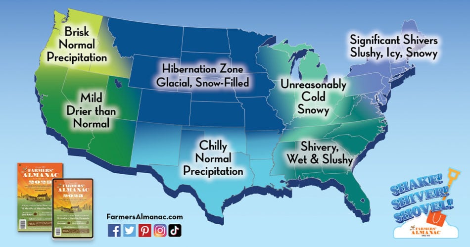
What's the Farmer's Almanac say?
Just for grins, I checked the Farmer's Almanac for predictions on the winter of 2022-23, and their theme nationwide is "Shake, Shiver and Shovel." Ha! They are predicting a strong winter nationwide, and
The Farmer's Almanac is calling for colder temps and normal precipitation, following the general trend expected from a La Nina winter.
Another indicator that can influence weather patterns was described this week by a meteorologist at Opensnow.com. Alan Smith talked about the Quasi-biennial Oscillation (QBO), which describes trade wind patterns in the tropics. A westerly phase of the QBO is expected to occur this winter, which is a phase that has shown some correlation with above-average winter precipitation across the Western U.S.
Although the sample size is admittedly small, winters that feature a La Niña combined with a westerly phase of the QBO appear to have a better chance of being wetter (and thus, snowier) than average across a large portion of the Western U.S.

It's fun for us skiers to dig into these things to get a glimpse of what may occur in the winter of 2022-23. But long-term forecasts are shaky at best, so we can't put too much emphasis on them.
In my experience, every winter is different. In a year when we start getting heavy snow in the mountains in November and rain in the valleys in Idaho, that bodes well for a potentially great ski season, and opens the possibilities of skiing on Thanksgiving weekend or the first week of December.
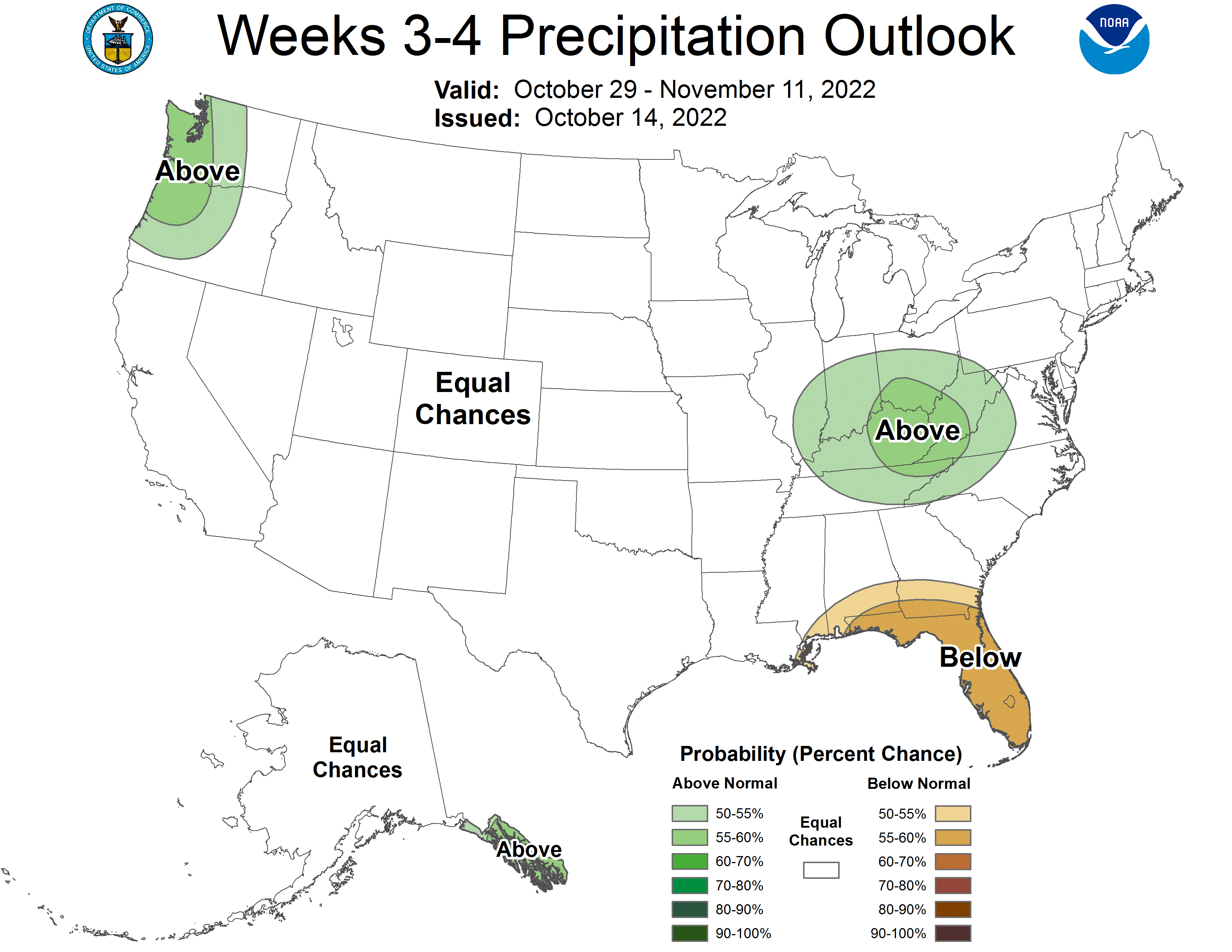
The NOAA Climate Prediction Center is forecasting colder and wetter conditions in the next week or so, and then equal chances in November, which is better than dry and hot!
Here are the forecast maps:


Well, there you have it!
A couple of key dates coming up for skiers and riders:
- The Bogus Basin Ski Education Foundation annual ski swap at the Western Idaho Fairgrounds will occur in two weeks, Nov. 4-6.
- The Warren Miller annual ski film will be shown at the Egyptian Theater on three nights, Nov. 17-19.
- SS


No comments:
Post a Comment