Thursday, March 27, 2014

Bounce back into winter mode, search for the best *pow*; Look for great stay-and-ski deals

Fresh turns in nice powder puts a smile on your face! (Courtesy Brundage Mountain) 
Skier shreds 7 inches of new at Brundage today. (Courtesy Brundage Mountain)
Hi all, 

I've been having a great time playing in the Boise Foothills lately, but with the cool and wet weather happening now and through the weekend, you might as well bounce back into winter-mode and go skiing this weekend. Are your skis waxed for speed? 

The weather forecast looks really promising for powder hounds at Brundage Mountain, Tamarack ResortBogus Basin and the West-Central Mountains, in particular. There isn't as much snow forecast for Sun Valley and Stanley, but there are some great lodging deals cooking in Sun Valley. More about that in a moment. 

Holy Powder Handstands, it is bombing snow in McCall! Brundage received 7 inches of new today, and it's nice, light snow with temperatures hovering around 20 degrees F. Damn! Shoulda been there today! They could get 8-14 inches Friday, 4-8 inches Saturday and 2-4 inches on Sunday, according to the National Weather Service. All told, that could be 14-26 inches over the weekend! The great snow god Ullr is looking kindly upon Brundage. Wow! 

Bogus got 5 inches of new today (Thursday), and it could get another 10-20 inches of snow by Sunday morning, according to the National Weather Service. I also see "rain/snow" mix at times on Friday and Saturday, so I hope you can avoid that. But there should be a steady dose of new storms rolling in and dumping snow Friday and Saturday. Watch the weather, Bogus' web cams and catch the best powder window that you can. 

Tamarack Resort also is going to get dumped on, with 10-21 inches forecast through Sunday. 

The forecast for Sun Valley calls for 3-6 inches of new snow through Sunday. But if you don't like skiing in a lot of powder, then Sun Valley might be the right call. It's a huge mountain with tons of great slopes, finely manicured groomers and plenty of challenge in the Baldy Bowls and bump runs like Holiday, Exhibition and Limelight. 

Best of all, you can save a ton of money on lift tickets by doing a combo stay-and-play package. Right now, you can stay overnight and ski a day at Baldy for $65/night, and kids 15 and under ski free! Contact VisitSunValley to book a room. 

McCall has some excellent lodging deals going on as well. Visit the McCall Chamber of Commerce's stay-and-play lodging page, and you'll see some package deals with lift tickets to Tamarack and Brundage ranging from $63.50/night to $90 a night and more. 
---------------------------------
Sagebrush and bitterbrush planting efforts improve habitat
 for mule deer, song birds and other wildlife. 
Closer to home, there are a couple of volunteer opportunities going on this weekend. Mary Dudley of Idaho Fish and Game could use more volunteers for planting sagebrush and bitterbrush in the Pony fire complex area north of Mountain Home on Saturday. People are meeting at the Nature Center at IDFG on Walnut Street at 8 a.m. Dress warm for foul weather, bring a lunch and water. Call Mary to RSVP if you'd like to go, 208-327-7099. There's another planting day planned April 5th, if you'd rather not plant in rainy weather. 

On Friday afternoon, Mike Pellant from the Healthy Hills Initiative in Eagle needs 10-15 more volunteers to plant forbs at the Eagle Sports complex near Floating Feather and old Horseshoe Bend Road from 3-7 p.m. They have 1,300 forbs to plant in a native plant education area. Call Mike for more information or to let him know you'd like to help, 208-867-1571.  

Thursday, March 20, 2014

Spring has sprung in the Owyhees! Exploring Sage Creek a good bet for the weekend

Our kids mess around in the rocks above the draw ... 
Hiking into Sage Creek from the trailhead.
One of many caves you'll see in there.
Balanced-rock features are everywhere in the middle of the canyon.
Hi all,

The slighter warmer, spring-like weather has been excellent for hiking, running and biking in the Boise Foothills. People are loving it, and they're out there in big numbers! And for good reason, spring is a perfect time to get out hiking, biking and running! March-June also is the perfect window of opportunity to explore the Owyhee Canyonlands before it gets blazing hot in July and the rattlesnakes emerge.

This week, I'd like to feature a couple of cool hikes in the Owyhees in the Sage Creek area, near Succor Creek State Park. Sage Creek is featured in our new guidebook, the Owyhee Canyonlands: An Outdoor Adventure Guide. It's a low-elevation destination, with tons of unusual and colorful volcanic rock and ash formations, and it's a kid-friendly and family friendly hike.

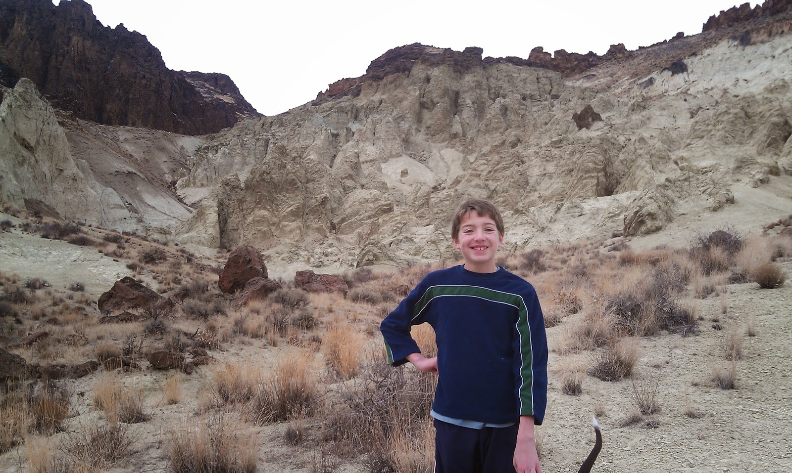
This is what I said in the book: "Sage Creek is a hidden jewel chock full of spectacular volcanic rock and ash formations in the creek-bottom and on the mountainsides as you hike along the creek ... One of the key highlights in Sage Creek is that you'll encounter multiple balanced rock features, some of them obvious phallic-type symbols, as well as spires, cliffs, fins and caves."
My son, Drew, loved the hike. 
Our guide features a 2.5-mile exploration out-and-back hike, cruising up the bottom of Sage Creek (rated easy for all abilities), and a 6-mile hike up to the top of McIntyre Ridge from Sage Creek (rated moderate to strenuous), with nearly 2,000 feet of climbing. Both of them are great!

How to get thereTake I-84 to the ID 55 exit in Nampa, heading west toward Marsing. Go west on ID 55 and  and Turn right on Chicken Dinner Road, then left on Homedale Road, and go to Homedale. Follow State Highway 19 west of Homedale, and then Highway 201 in Oregon, to a signed turnoff for Succor Creek State Park on the left. Head south on the dirt road. It's 12.1 miles to the unsigned right-hand turnoff  for the Sage Creek Trailhead. There is a lone scrubby cottonwood tree at the turnoff. Follow the primitive two-track road over several creek-crossings to the trailhead .9 miles from the Succor Creek Road.   
Nice rhyolite cliffs with Wendy in the foreground. 
Road access challenge: 4WD high-clearance vehicle is required to reach the trailhead; multiple creek crossings are involved. It's possible, however, to take a 2WD vehicle to the Sage Creek road junction, and hike from there. Add .9 miles to the trip if you start from Succor Creek Road. 

Hike #1 - 2.5-miles out and back
Cruise up the creek-bottom of Sage Creek, picking your way up the draw as you like. Hike at least a mile upstream to see the balanced rock features on the mountainsides above the draw as well as many other interesting rock formations. The volcanic ash flows in the area have turned different shades of white, orange and green over time. These formations are very erosive ... you can scratch the ash with your fingernails. Wear shoes that can get wet ... I doubt there's much water in the creek-bottom, but you will encounter some pools along the way.   
Hiking down-canyon back to the trailhead.
Hike #2 - 6-mile loop
From the end of the road, hike up-canyon and cross the creek to the left side. At mile .2, climb up the left-hand draw. It's a super-cool hike through many rock formations as you ascend the draw. It's about 2 miles to the top of the saddle near McIntyre Ridge. Climb to the top of McIntyre Ridge if you'd like. This area overlooks Succor Creek State Park to the east and Three Fingers Rock and many other features to the west. On the way down, descend the ridge to the left of the draw you climbed up, and enjoy a cool hike down into the draw. You'll pass by the "official" balanced rock on your way into the draw. Turn right at the bottom of the draw, and hike back to the trailhead.

Family pic in Sage Creek. November 2012. Kind of rare to get our 4 kids together for a family hike!
L-R, Drew, Tom with our pointer Huck, Wendy, Elena, Quinn, Steve 
Camping notes: You could camp in the bottom of Sage Creek. Quiet spot. Self-support camping. You also could camp at Succor Creek State Park, which has a public rest room, very close by, but that will be much more crowded. If you'd like to explore some other areas, Succor Creek Road connects to Leslie Gulch, Three Fingers Rock and many other areas worth checking out in our guidebook. 

If you're looking for ideas about what to do over Spring Break next week, check out my blog from last year with many ideas for recreation and camping close to home

Have fun! 
-SS   

Thursday, March 13, 2014

Boise Foothills trails dry up fast, ready for hiking, biking, trail-running; Have fun!

Let the spring riding season begin! Bucktail Trail in Military Reserve 
Happy Puppy on Military Reserve Connector! 
Hi all,

Wow, living on the edge of the desert, it's amazing how quickly the Boise Foothills trails can dry out when we get a combination of wind and sun after all the moisture we had in February.

I checked the Ridge to Rivers web site and trail blog yesterday, and they gave the green light to go enjoy the trails. I went for a quick ride from Camelsback Park, up Owls Roost to Kestrel, up Crestline to Sidewinder Summit, and I was amazed how the trails had dried out so quickly! Like in a matter of a couple days since Monday's soaking rain and hail.

This is exciting to me as I love to get a quick workout in the foothills whenever possible. I'm sure many of you feel the same way. There were tons of people hiking, dog-walking, running and biking in the foothills yesterday evening.

So for this week's tip, I'd recommend getting out on the foothills trails to enjoy a nice hike, dog-walk, bike ride or trail-run. I'll provide a list of recommended loops, starting with some easy kid-friendly routes and building to more challenging ones.

Before you go, pay heed to these words of advice from R2R:

  • Walk, run or ride through the isolated puddles out there if they cover the whole width of the trail. If you go around on the edges, you end up widening the trail. 
  • Be sure to yield to uphill traffic of all kinds. Mountain bikers need to come to a stop when encountering uphill traffic, move off to the side of the trail, see hello, and let people pass. 
  • Be aware that you may encounter some trail sections that suffered significant damage from heavy runoff 3-4 weeks ago. You will see evidence of this on Corrals, Bob's, Central Ridge in Military Reserve and on the Five Mile Creek trail. R2R crews are out there working on repairing these sections or installing water dips or water bars. They are working on Bob's at the present time, and then will move to Central Ridge, Corrals and Five Mile, in that order. 
Now, for the recommended loops. All of these are featured in detail in my books, Boise Trail Guide: 75 Hikes and Running Routes Close to Home, and Mountain Biking in Boise
  • Red Fox-Owls Roost Loop - Rated easy. 2.3 miles total distance. About one-hour travel time on foot. 30-minutes or less for runners and bikers. Great for young kids! Start at Camelsback Park, pick up the trailhead east of the tennis courts. Go up Red Fox and return on Owls Roost or vice-versa. You will need to cross 8th Street by the Foothills Learning Center to complete the loop. Be sure to have your dogs leashed on the sections of trail that require it, and pick up after your pet. 
  • Try the Polecat Finger Ridge Loops - Rated easy to moderate. Long loop is 5 miles; Doe Point out and back is 2.5 miles. 1 hour riding time on a bike; 1-2 hours hiking time. Take Cartwright Road west from Bogus Basin Road over two summits and then watch for the Polecat parking area on the left. This is the main trailhead, but a new one will be built off of N. Collister in the near future. Proceed up the trail to the first junction on right, and follow that to do the Polecat Loop. Go straight if you want to take the shorter route to the top of Doe Point.   
  • Climb Table Rock from the Bishop's House by the Old Pen. Rated strenuous for hikers and runners; Advanced intermediate ride for mountain bikers. Pick up Trail #15 at the trailhead and climb to the top of Table Rock. It's less than 2 miles to the top, but the climb gets progressively steeper as you approach the summit. It's a super-steep granny gear climb on a bike for the last half mile. Once on top, look for Trail #16 on the backside of Table Rock and take that around the quiet side of the bluff back to Trail #15 and return to the trailhead. 
  • Kestrel-Red Cliffs Loop - Rated moderate. Distance is 5 miles if you start from Camelsback Park. Hikers can shorten the route by parking at the Jim Hall Foothills Learning Center on 8th Street. 600-feet of elevation gain. For this one, you can do the loop clockwise or counter-clockwise. To do it the easy way, take Owls Roost or Red Fox to the Foothills Learning Center. Pick up Kestrel Trail, climb Kestrel to Crestline, go left on Crestline and go less than a mile to a left-hand turnoff for Red Cliffs. Follow Red Cliffs on a fun curvy descent back to the Foothills Learning Center. It's a little stepper if you start on Red Cliffs and come back on Kestrel.    
  • Cross-Foothills Loop - This one is best for trail-runners and mountain biking. Distance is about 10 miles. Riding time is less than 2 hours. Running time would be similar, depending on how fast you run. Start by climbing Bogus Basin Road to the Corrals Trailhead 1.2 miles from the stop sign at Highlands School and Curling Drive. Take Corrals to Corrals Summit, descend over to 8th Street, cross the road, and drop into Hulls Gulch. At the Hulls-Crestline junction at the creek, cross the creek and take Crestline almost to the trailhead, and turn left on Military Reserve Connector trail, climb to Central Ridge and descend to the Toll Road trailhead. 
  • Rocky Canyon - Five Mile -Watchman Loop - This ride is still one of my all-time favorites in the Boise Foothills. It's a great workout; the scenery is fantastic on Watchman and Curlew Ridge, and it's a great length for my pointer, Huck. Distance is 10.2 miles from the end of the pavement on Rocky Canyon Road. Travel time is 1.5-3 hours, depending on how fast you ride. Vertical gain is 1,906 feet. Climb Rocky Canyon less than 3 miles to Five Mile Creek Trailhead on the left. Climb Five Mile Creek past the Orchard Gulch junction and you'll come to the Watchman Trail. Most of the climbing is over now, and you can enjoy a really fun ride from here. Follow Watchman to the junction with Trail #6, go left to follow Three Bears Trail on Curlew Ridge to Shane's Summit. Go left and drop out on Rocky Canyon Road, and return to the trailhead at the end of the pavement. 

Jump Creek Road closed temporarily. BTW, I saw that the BLM is doing some construction work on the access road to Jump Creek canyon, near Marsing. This is a popular spring destination, but the road will be closed for repairs from March 24 - May 19, according to an article in today's Idaho Statesman

Steve talks about his outdoor tips every week with Ken and Misty on 94.9 FM The River on Friday at approximately 7:30 a.m. More information about hiking, running, biking and paddling in SW Idaho can be found on Steve's website at stevestuebner.com.

Thursday, March 6, 2014

Whale-watching, sea kayaking trip in Mexico makes for a great winter or spring vacation

Now this is living! Sea kayaking on Isla del Carmen. We snorkeled here, too. 
Danielle Rodier of New York City took some great photos and video on our trip. 
Light winds made for easy going paddling between the islands. We were lucky! 
Wendy counted more than 61 bird species on our trip, including a peregrine falcon on the last day.  

We saw lots of tropical fish ... never saw a sea turtle, tho ... 
Hi all,
Wendy and I have been overdue for a vacation, so at the Idaho Rivers United fund-raiser/auction in December, we bought a 10-day whale-watching, sea kayaking trip from ROW Adventures and booked it for late February. It turned out to be a home-run vacation for sure. We highly recommend it! 

ROW Adventures is based in Coeur d'Alene. They do Idaho raft trips and all kinds of cool stuff all over the world. Wendy and I know the owner, Peter Grubb. We like their style of trip, focusing on adventure, comfort, a strong component of education and interpretation, and most of all, fun! 

The trip was based out of Loreto on the east coast of the Baja California Sur peninsula. Loreto is just a two-hour flight directly south from LAX. It's located on the coast of the Sea of Cortez, known as the "World's Aquarium," and it's a two-hour drive from Magdalena Bay, where we did the whale-watching adventure with gray whales. 
Sea of Cortez is on the right side of the map; Pacific Coast and Magdalena Bay on the left ... 
The weather was fab - 85 degrees almost every day, and during our sea kayak adventure, the winds were light and calm, making for easy-going paddling in the gorgeous Sea of Cortez. 


Our trip started with whale-watching. ROW Adventures put us up at the Mission Hotel in Loreto (very nice digs), and then a van picked up our group of eight people for the two-hour ride over the mountains to Magdalena Bay. We brought packs with our clothes for the next three days, and ROW provided all of the camping equipment, food and guides. 

At the bay, we grabbed some life jackets from an outfitter and jumped into a 20-foot white fiberglass boat with padded seats. A local man guided the boat and knew how to get close to the gray whales. At this time of year, the female gray whales have had their babies, and they're hanging out in the bay, allowing the calves to grow and learn the ropes before swimming to the Gulf of Alaska for the summer. The whales are very social ... we had no idea we'd be able to touch them, scratch their bellies and get so close! It was a hoot! 


Over three days, we had multiple two-hour whale-watching sessions. On the second day, we had our best session with multiple female gray whales sidling up to our boat with their youngsters, coming up for pets, and smiling at us, showing us their big tails and the whole deal. It was such a treat! 

The base camp for the whale-watching trip was located on a sandy spit of land between the bay and the Pacific Ocean. It was an easy hike over to the ocean to look at desert plants and hike the sandy dunes next to the sea. Plus you could walk along the ocean and check out the sea shells and enjoy the soothing feeling of the salt water sifting through your toes. Each spacious tent had two cots in it, and single people could request their own tents, if they wanted them. 

On Day 3, we left the whale-watching camp, drove back to Loreto, and stayed at the Mission for a night before the sea kayaking adventure started the next day. I woke up that day with a big knot in my stomach from god knows what. "Montezuma's Revenge" kicked in, and I had a bad case of diarrhea that left me weak, dehydrated and unable to attend our farewell lunch. I went to the medical clinic in Loreto, got some drugs, and slept it off. If I was going to get sick, at least it hit me at a time when I was close to civilization. 

The next day, I needed to sleep and recover. That illness hit me like a ton of bricks. Couldn't eat anything for 1.5 days, but I felt better that evening and started to gain some strength. ROW Adventures has a motor boat that accompanies the sea kayak trip, so they were able to come get me on the morning of Day 2, so Wendy and I could rejoin the trip. 

On the extra day in Loreto, Wendy went out to see blue whales, sea lions and dolphins with a group she ran across at the harbor. She got some killer video of about 200 dolphins leaping about on the boat wakes, close ups of sea lions and blue whales. It was an awesome day for her in the Sea of Cortez. Fortunately, she got some video so I could enjoy it, too!

Our sea-kayaking trip was just as wonderful, if not more because we got to explore the islands in the Sea of Cortez, go snorkeling every day, and enjoy beautiful weather. We visited two islands as part of our journey. The secret coves and caves we visited along the way were very cool. The water is turquoise and gin-clear, so it's like you're paddling with a glass-bottomed boat. Most of us paddled two-person kayaks, which handled very easily, and with smooth fiberglass bottoms, they were sleek and fast. Our support guide went ahead of us during the day in the motor boat, set up lunch at our lunch stops, and set up tents and the kitchen area before we arrived. Very cool. 
We did some neat side hikes from lunch or camp. 
Tarantula seen on one of our side hikes.
See the sea shell fossil in the rocks? 
We saw some blue whales as part of that journey, and we also saw dolphins multiple times along the way. Now I know why they call the Sea of Cortez "the World's Aquarium." What a treat to visit that wonderful place. 

For more information, see ROW Adventures web site on the sea kayak trips. You can add on the whale-watching adventure too. 

-SS