Thursday, August 27, 2020

Smoke is supposed to clear by Sunday ... Big cool-down coming ... Bow season starts Aug. 30 in many locations


Hi all, 

Quite honestly, I don't have a lot to say this week. It's been really smoky for much of the last 5 days, and that sure puts a damper on my interest in going outdoors for a hike or a bike ride. Idaho DEQ has been recommending laying low mostly this week to avoid damaging your lungs. Swimming is a little better to at least cool off. 

I took advantage of a brief window of opportunity Wednesday morning and went for an early-morning bike ride. The brief rainstorm Tuesday night seemed to push the smoke out of the valley a bit. It remained pretty clear that morning to feel safe for an outdoor outing.

The good news is that a frontal system is supposed to move through Idaho Saturday night, and drop temperatures about 15-20 degrees by Sunday. The high temperature in Stanley is forecast to be 68 degrees F on Sunday, and 66 degrees F in McCall.

Hence, Sunday should be a great day to get out for a walk, run, hike or bike ride in the cool weather. If you head out camping this weekend, make sure to bring some warm clothes for Sunday morning! 


Another tip is that Sunday (Aug. 30) is the beginning of big game archery season in many parts of Idaho, depending on the big game unit. That means there will be a lot of people in camo and face paint out roaming the woods on foot, by truck or ATV/UTV. Just a head's up that you are likely to run into bow hunters for the next 30 days, following by rifle seasons. Consider putting something bright on your dog if you're going out in the woods. 

Here's a link to the NOAA Smoke Map

Otherwise, let's hope the skies stay clear for a few days, with more of a Northwest flow vs. a Southwest flow, which has been pushing smoke from California and Oregon into Idaho.
-SS

Thursday, August 20, 2020

Try a scenic chairlift ride at Brundage Mountain or other Idaho ski areas while you still can ...


Hi all,

I've been hibernating in our cabin in McCall this week, blasting away on some writing and work projects, while trying to get out once a day for a hike, bike ride and/or a swim. I love how easy it is to do all of those things close to our cabin! 

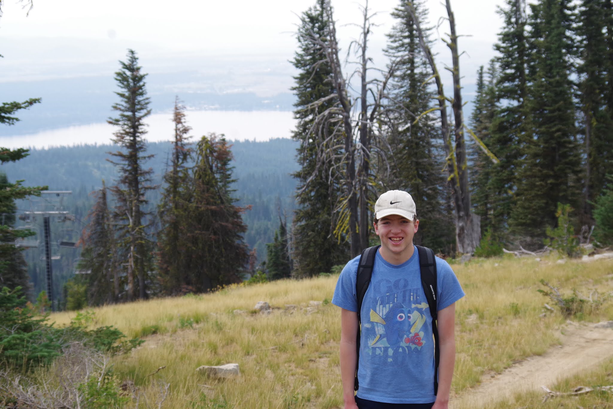
On Wednesday, I thought it'd be neat to take my younger son, Drew, on a chairlift ride to the top of Brundage Mountain, and then hike down. We usually take Drew on hikes from the bottom of the mountain at Bogus Basin, and he does great climbing the mountain with us and doing a big loop to enjoy the 360 degrees views and the surrounding countryside. 

For Drew, a high-functioning autistic lad, this was his first chairlift ride. He doesn't like the thought of skiing, so we go snow-shoeing instead. But I thought, what a perfect thing to do for kids with disabilities to take them out of their comfort zone a little, and let them enjoy the thrill of getting a free and safe ride to the top of the mountain on a super smooth chairlift -- in the summer when it's warm! 

It might not be that big of a deal to us, but it's a BIG deal to them! 

Brundage operates its lifts Wed-Sunday. The one-ride lift ticket cost us $15 each. I wanted to take my pointer so he could get some exercise, but no dogs are allowed on the chairlift (understandable!), and no dogs are allowed on the Brundage trails. So we left Huck at home. 

The nifty thing about scenic chairlift rides with detachable quad chair systems is how easy it is to load and unload. The chairlift slows down to a crawl as you get on the chair, and it does the same at the top, decelerating as you approach the lift station. A sign says, "Keep your feet up!" when approaching the landing platform.  

At the bottom of the Bluebird Express lift, Drew walked right up to the loading platform with me and loaded on the chairlift like a champ. We took off our day packs and held them in our lap so our backs were free to lean against the back of the chair. We lowered the safety bar as soon as we were launched, and then Drew could see he was safe and sound. 

"Whew!" he said after we lowered the bar. "I sure don't want to fall off this thing. It's a long way down!" 

"But don't you feel safe now with the safety bar down?" 

"Yeah, I think so. I just don't want to fall off," he said. 

I talked about looking for deer and elk in the trees on the way up (we see tons of deer around our cabin), and we could see lots of wildflowers growing under the chairlift on the way up. Tall red paintbrush were in full bloom. 

The sky was kind of hazy on Wednesday because of some new lightning-caused wildfires in the Payette National Forest, and also fire smoke blowing into the area from Oregon and California. So we couldn't see the Wallowa Mountains in Oregon ... but Drew didn't really mind.

To hike down from the Brundage summit, they recommend taking hiking trails over by the Lakeview chair, and you can walk down the Growler xc trail over by the long Temptation ski run. You also can take the South Lodge access road down from the top, if you might prefer walking on a dirt road vs. a singletrack trail where you might encounter bikes. 

The views from the Lakeview chair area are splendid! Drew noticed Payette Lake, the city of McCall, and the McCall Airport. We saw lots of colorful wildflowers on the way down, quite a few chipmunks and squirrels, a goshawk cruising the treetops for a meal (bonus), and only one other hiker. 

Brundage, Bogus, Tamarack Resort and Sun Valley will be running their lifts through Labor Day weekend, and then it'll be up to your human power to reach the ski area summits. I highly recommend taking the lift to the top for a fun hike or bike ride on the way down. 

After we finished our trip, Drew said, "I'll never do that again," as he often says after the first time he does something new. But I promise you, it won't be his last chairlift ride. If anything, I wondered why it took me that long to take him on a chairlift!
- SS   

Thursday, August 13, 2020

OMG! Last weekend before school starts! 10 ideas for outdoor outings to beat the August heat!


Hi all,

It's kind of hard to believe, but summer vacation is on the wane, especially for families with school kids! There's only one weekend left before Boise Schools start up on Monday, Aug. 17. How have you done on your summer outdoor punch list?

This has been one of the most challenging summers ever because of COVID-19. Doing outdoor trips on a day trip-basis, close to home is smart and safe. Many people have missed out on planned trips out of state or out of country this summer because of COVID. 

For those who are looking for some last-minute ideas for outings this weekend, here are some recommendations ... temperatures are warming up into the triple digits, so many of these are geared to beat the heat:

1. Ride the ski lift to the top of Bogus Basin, Tamarack Resort, Brundage Mountain or Sun Valley and go hiking or biking from there. Good way to find cooler weather at mountain top-elevations! Spectacular 360-degree views off the summit! 

2. Go fishing - Go wade-fishing on the Boise River and stay cool. See the list of Idaho Fish and Game's Family Fishing Waters to find some other recommendations close to home.

3. Go SUP'ing, boating or swimming in a refreshing Idaho lake like Lucky Peak, Arrowrock Reservoir, Lake Cascade, Deadwood Reservoir, Payette Lake, Redfish Lake, or Priest Lake.

4. Float a river (day trip) - we're blessed with so many options here. Have you floated the Boise River this year? How about the Payette River -- there's the Main Payette, South Fork Payette or Cabarton run on the North Fork. Check with Cascade Raft, Idaho Whitewater Unlimited, Bear Valley or the Payette River Company about guided trips. The Payette's calmer sections are great for stand-up paddle boarding (SUP), sit-on-top kayaking and canoeing.

5. Climb a mountain - The pinnacle is to climb Mount Borah, the tallest peak in Idaho, but there are so many other options in Idaho, with dozens of peaks over 10,000 feet and 8 peaks over 12,000 feet. See Idaho mountain expert Tom Lopez's list of recommended mountain peaks. McCall mountain expert John Platt also has an extensive list of peaks and mountains that he's climbed.

6. Go backpacking in the Sawtooths, White Clouds, Pioneers or Big Lost Mountain Range. See Michael Lanza's recommended hikes in the Sawtooths in his blog, the Big Outside. See a recommended major loop in the White Clouds in Backpacker mag. For a great hike in the Pioneers, see my blog post about hiking Broad Canyon. 

7. Go camping on the North Fork or Middle Fork Boise River via Idaho City. Oodles of car camping areas up located up there, some with services and some self-support. Consult a Boise National Forest Map to find developed fee campgrounds with water hookups and rest rooms.

8. Paddle the Mid-Snake River to Shoshone Falls. You can rent kayaks or SUPs at Centennial Park in Twin Falls. Here's a recent post I wrote about that adventure.

9. Go rafting or jet boating in Riggins or Hells Canyon - Check with your favorite outfitter in the area to get out on the water.  Or check the IOGA web site

10. Go mountain biking on the Idaho Classics like Loon Lake, Fisher-Williams, Around the Mountain at Bogus, Ketchum-Sun Valley Trails, Galena Lodge Trails, or Jug Mountain Ranch trails. 

There you have it! Have fun and be safe!
- SS

Thursday, August 6, 2020

Find your Private Idaho at Harriman State Park, Ashton-Tetonia Rail-Trail in E. Idaho

Hi all,

Last week, I traveled to Salmon and Eastern Idaho to work on some conservation stories, and Wendy agreed to meet up with me at Harriman State Park last Thursday to stay in one of their yurts and spend time in that quiet, beautiful corner of Idaho.

We planned a long weekend to ride the cool bike trails at Harriman, do some fishing, maybe float the Big Springs section of the Henry's Fork in our double inflatable kayak, and ride the Ashton-Tetonia Rail-Trail. I always like to stop by Mesa and Lower Mesa Falls while I'm in the 'hood, too.

We got a great start to our little stay-cation Thursday afternoon. We checked into the Wythea yurt after 3 p.m., rode the bike trail around Silver Lake, saw a yearling moose in the woods, and then went over to the historic cabins overlooking Millionaire's Hole on the Henry's Fork and soaked in the grandeur of the scene.

Here's a long-form video that I produced several years ago for Life on the Range about the history, fishing, recreation and grazing at Harriman Park:


If you haven't ever been to Harriman State Park, it's truly one of Idaho's gems in the state park system.
Looking out into all of that gorgeous open space in the meadows surrounding the Henrys Fork leading up to Last Chance and Island Park is quite a sight to behold. If you hang out by Millionaire's Hole in the evening, you might see elk and moose wander out into the open at dusk. It's a place that always takes my breath away.

The Harriman Family gifted the property to the state of Idaho back in the 1960s under a provision that Idaho would have to create a state parks system to receive that incredible gift. Former Gov. Robert Smylieand the Idaho Legislature came through in 1965, creating the state park system and Harriman State Park became an official state property.

Wendy and I went out to eat at the Trout Hunter's Lodge in Island Park Thursday night, right on the banks of the Henrys Fork as multiple bug hatches were swirling above the river in the evening twilight.

I didn't sleep very well in the yurt that night. The next morning, I woke up with diarrhea. That continued through the morning, and I felt like crap. Must have picked up some bad water or food along the way, and it was hitting me like a ton of bricks. Wendy had reserved a room in Ashton that night, and I headed for the hotel to sleep it off being close to a bathroom. So much for doing anything on Friday for me. Wendy went swimming and met up with an old friend is Island Park for dinner.

I slept from 2-10 p.m. that day in the hotel room. I woke for a few minutes, and then slept through the night to 6 a.m. The diarrhea continued. But I had enough energy to drive home to Boise. I threw my stuff in the car and zipped home on the freeway. Because diarrhea is listed as one of the possible symptoms of COVID-19, I called Primary Health and signed up for a test at noon on Saturday to follow protocol.

Knowing that it'd take 3-5 days to get test results back, we had to cancel our Lower Salmon River trip, planned for Tuesday-Sunday this week before Quinn goes back to Colby-Sawyer College in New Hampshire to finish his senior year. DAMN! That pissed me off. And it was depressing.

I was pretty sure I just had a stomach bug. But my oh my, it was a doozy. It knocked me down with fatigue for three days. I finally started feeling a bit better by Sunday evening, and then Monday I felt much more energetic, but I still couldn't eat anything and had no appetite because of the Imodium I was taking to treat the loose bowels. Finally, Tuesday, I emerged feeling more normal, and Wednesday morning, I got learned that my COVID test was NEGATIVE. 

Anyway, I still would recommend a fun stay-cation in the Island Park area to do the things mentioned above. Here are some links to find the fun:

Harriman State Park - The 16,000-acre park has 22 miles of hiking, biking and horseback riding trails. You can go on a guided horseback ride, too. Rent a yurt or one of their cool cabins and stay in that gorgeous spot to soak up the scenery and enjoy all of the amenities right out the back door. 

Ashton-Tetonia Rail-Trail - The trail is 29.6 miles long. You can start in Ashton and ride to Tetonia or vice-versa. There's a local shuttle service available. It's a gravel surface trail with several very high bridges over Fall River and Bitch Creek (the tallest and longest one). You can see the backside of the Teton Range and the Grand Teton as you're riding the trail through seed potato fields and grain fields. Very quiet and lightly used trail.

Floating and fishing the Henry's Fork - There are many sources that are more knowledgeable than I am about fishing the Henry's Fork, but suffice to say, it's a very challenging stream to fly fish. People come from all over the world to do it because of the large rainbow trout that lurk below the surface. If you don't fish, there are numerous sections of the Henrys Fork that you can float in a raft, drift boat, IK or SUP. Pick up a map of the Henrys Fork in Island Park or Harriman Park. The Big Springs section is crystal clear. Really special.

Mesa Falls - 114-foot Upper Mesa Falls is the tallest and most spectacular of the two falls. Take the scenic drive from Ashton or Island Park to the falls and take the short walk over to an overlook to see the falls. Well worth the drive and the walk!

Have fun and be well!
- SS

Thursday, July 23, 2020

A multitude of mountain lakes and hikes beckon in NW McCall

Hi all,

It seems that many visitors to McCall are attracted to the Lick Creek Road area for hiking to high mountain lakes for day trips or backpacking. Actually, the high country around McCall has high mountain lakes in many locations. But you shouldn't overlook the hikes and lakes off Goose Lake Road.

That's my topic this week.

Previously, I've blogged about numerous kid-friendly short hikes in McCall, including going to Upper Hazard Lake off the Goose Lake Road. Most of the hikes/lakes in that area are kid-friendly, from super young kids to teen-agers. Think about bringing a fishing pole. Don't forget your bug stuff, either.

Wendy and I joined our COVID buddies Mark and Laurie Anderson for a super pleasant hike to the Grassy Mountain Lakes last Saturday. Wendy and Laurie also were interested in climbing to the top of Granite Mountain, but since Mark and I had done that a number of times, we went for the Grassy Mountain Lakes.

Driving up the Goose Lake Road, it's pretty obvious that Goose Lake itself is well-known and popular with campers, paddlers, anglers, SUPs, etc.

It took a little over 30 minutes from McCall to the well-marked trailhead for Grassy Mountain. It's only two miles to the lakes. We hiked to the top of Grassy Mountain for a bigger view of the whole countryside, and my oh my, what a view! The Wallowas way off to the west. Cuddy Mountain. Seven Devils. Bruin Mountain. Hard Butte. Patrick Butte. The Little Salmon River canyon. The Frank Church-River of No Return Wilderness. And then looking back to McCall, you can see a whole series of peaks and ridge-tops that comprise the Payette Crest. In other words, it's God's Country!

All of that is really inspiring to me, refreshes my soul.

We even found some snow on top of the mountain for Huck to check into for a fresh drink.

Looking west, we also could see Coffee Pot Lake, Disappointment Lake and Lake Serene. We'd leave those for another day, since we were day hiking.

On our way back, we took a dive in upper Grassy Mountain Lake, and that was super refreshing ...

Farther up the Goose Lake Road, you'll also should check out:
    - Hazard Lake and Upper Hazard Lake - car-camping, hiking and fishing at the main lake, with an option to hike to Upper Hazard on an easy trail. 
    - Twin Lakes, Hard Butte Lakes, Rainbow Lake - Much longer drive to the end of the Goose Lake Road to reach those lakes. Park and hike from there. I've biked to Twin Lakes and Rainbow Lake.
    - Climb Hard Butte if you're in the 'hood.

Pick up a McCall Adventure Map or a Payette National Forest map for driving directions and general reference. I also like to create a more detailed topo map for my hikes for easier route-finding.

Have fun!
- SS


Thursday, July 16, 2020

Break out of the Covid duldrums with a thrilling Tamarack zipline adventure


Hi all,

The adrenaline and excitement started for me before I even arrived at Tamarack Resort this afternoon for a zipline adventure. And that felt great -- what a welcome break to do something exciting during these weird times with the COVID-19 pandemic.

The last time I did a zipline tour was in the jungle in Costa Rica to cap off a week-long whitewater paddling adventure. On that trip, we did zips through the jungle, landed on top of a waterfall, and then rappelled down the face of a flowing waterfall. That definitely took me out of my comfort zone! The water was very warm, but the footing was definitely slippery!

We had six people and two guides in our group today at Tamarack Resort. We were all masked up as we checked in at the Sports Dome, got our zipline harnesses on, and got an orientation talk from our fun guides, Austin and Bryant. We took the Tamarack Express chairlift to mid-mountain to begin our adventure.

We started with a couple of "baby zips," and then things ramp up to some really fast, long spans across the deeply forested canyons in the folds of West Mountain. 

"If you scream all the way across you'll have more fun," Austin advised.

Everyone had a blast. I felt nervous at first, but I knew the guides had me in all of the proper safety gear to hold me as I zipped across the canyons. There are eight zip spans altogether and two suspension bridges to experience as part of the tour. You hike on Tam trails in between most of the zips.

After the third or fourth zip, one of the tricky maneuvers is on a deck after you've landed from a zip. To get to the next zip, we all had to rappel off that deck about 20 feet or so. It's definitely a "leap of faith" to trust the system and drop off the deck. My ride down was kind of a goofy as there was some extra slack in the rappel line, and I kind of bounced off the deck before whirly-birding down to the landing. I probably didn't step off correctly in the first place. Good thing for the safety harness! I heard the guide mutter that one customer had taken 20 minutes of coaxing to drop off that deck. 

Following that little maneuver, we did a zip called "Leap of Faith" because there is no runway whatsoever, just leap off the deck and go! With each zip, I felt more comfortable and thoroughly enjoyed the rides, watching the trees whiz by, taking a quick glance of Lake Cascade below, and just enjoying the beautiful scenery all around you at Tamarack Resort.

I tended to spin around backwards on several zips, approaching the landing deck backwards, which wasn't really my first choice. But I didn't really figure out how to control my spins all that well. The guides will still catch you, no matter which way you land. On my last 3 zips, I spun around 360 degrees, and landed facing forward. Much better~!

Overall, we dropped 3,500 vertical feet on the eight zip spans. Totally thrilling ride all the way. I highly recommend it.
.
Tamarack zip tours cost $109 plus tax per person. Groups of six or more save 20 percent. Our trip took two hours on the nose. Tamarack has morning and afternoon trips available.

While you're at Tamarack, you might try their excellent mountain bike trails, especially the long, entertaining trails off the top of the Tamarack Express lift. We saw a lot of people riding the trails today, but there's still plenty of elbow room. Tamarack also has waterfront services and raft trips on the Cabarton section of the North Fork of the Payette River.  

More information at tamarackidaho.com.

Thursday, July 9, 2020

Explore the Hells Canyon Scenic Byway - A stellar 3-day trip from Halfway to Joseph


Hi all,

The Hells Canyon Scenic Byway is not that well-known, but it's a pretty cool scenic drive in my book. The whole loop around the Wallowa Mountains is 213 miles on the Oregon side of the Snake River. Take your time and soak in the scenery.

On the first couple days of Cycle Oregon three years ago, Wendy and I and 2,000 other cyclists rode the Hells Canyon Scenic Byway from Baker to Halfway, and then we all did a HUGE 95-mile day from Halfway to Wallowa Lake State Park via the Hells Canyon Scenic Byway and Forest Road #39.

After doing that ride, I wanted to come back and explore the Forest Road #39 area in particular, and just do some leisurely camping and hiking. My buddy Norm Nelson was game to go over there last week, so we did a 3-day trip, hanging out mostly around the Imnaha River campgrounds, and doing some hiking and fishing.

For my blog post this week, I'm recommending a bigger 3-day itinerary for families and friends that covers a few more popular sights along the way.

For Day 1, I'd recommend driving I-84 to Baker, Oregon (2 hours travel time), and then take the Hells Canyon Scenic Byway, Oregon Highway 86 to Halfway, Oregon (1 hour+ driving time), the gateway to the southern end of the Wallowa Mountains and Eagle Cap Wilderness. After a half day's drive, take a break, and enjoy the clean mountain air and impressive views of the Wallowas.

In Halfway, perhaps stay at a local Bed and Breakfast like the Inn at Clear Creek Farm, the Pine Valley Lodge, or the Halfway Motel and RV Park.


For Day 2, go east on the scenic byway toward Oxbow Dam in Hells Canyon. About 10 miles east of Halfway, turn left on Forest Road #39 (curvy paved road) and drive 20+ miles over the first big summit and visit the Hells Canyon Overlook. There's a rest room there, parking, and a paved accessible trail to a stupendous view of Hells Canyon.  

Last week, the overlook area was smothered with wildflowers of all kinds. The tell-tale peaks of the Seven Devils poked up on the Idaho horizon. Looking below, I could follow ridgelines plunging over 5,000 feet down to the Snake River (can't see the actual river). It kind of takes your breath away. I've been down in the bottom many times staring up from the river at the forested peaks looming above. 

After visiting the overlook, drop down to the Imnaha River campgrounds. There are a number of campgrounds that you could choose from along the main road, or up a separate road to the Imnaha River trailhead to the Eagle Cap Wilderness. We stayed at Indian Crossing Campground and had plenty of elbow room. We went hiking upriver to try out the fishing (water was very high and fast), and the Blue Hole advertised on the map and signs seemed pretty quiet.


It was still fun to climb down to the river, stand on a nicely-positioned casting rock, and cast some dry flies in the stillwater pool to see if anything might rise to the surface.

The Imnaha River hiking trail was very easy walking ... totally buffed and well-maintained in the lower 3-4 miles.

Other campgrounds in the immediate area include: Coverdale, Hidden, Ollokot, Blackhorse and Lick Creek (top of 2nd summit). There are a number of primitive self-support pull-out spots as well.


For Day 3, I'd recommend taking Forest Road #39 over Lick Creek summit and Salt Creek Summit and head for Joseph and Wallowa Lake State Park. The drive will take a couple of hours. Joseph is a charming little town with cool brew pubs, sidewalk cafes, art galleries and museums.

Book a room in Joseph or camp at Wallowa Lake State Park and you can't go wrong. The views from Wallowa Lake State Park are drop-dead gorgeous of the lake and the north end of the Wallowa Mountains/Eagle Cap Wilderness. There's hiking readily accessible up the West Fork or East Fork of Wallowa Creek. And there's the Wallowa Lake Tramway, which provides a quick trip to the rooftop of the Eagle Caps. There's food and drink available at the top.

According to the Wallowa Tramway web site, in 15 minutes, you ride from the bottom terminal (elevation 4,450 feet) up to the stop of Mt. Howard at 8,150 feet. The mountain is named for Major General Oliver O. Howard, who led U.S. troops in the Nez Perce War of 1877 and drove Chief Joseph and his people out of their ancestral homeland.

On Day 4, return to SW Idaho (or wherever your home might be) on Highway 82 back to La Grande, hop on I-84 and it's 2.5 hours back to Boise.

There you have it!
- SS