Thursday, November 19, 2015

Go play in the snow! Boot-hiking, xc skiing, snowshoeing, snow biking all are doable

Pic from Grand Targhee parking lot 

Thanksgiving ski vacation in the Tetons? How can you go wrong? 
Snow biking to Skyline Yurt last Saturday ... 0-4 inches of snow at that time. 
Fat biking on the Boise Ridge Road (courtesy Aileen Frey)
Hi all,

If you're like me, and you get excited about the prospect of playing in the snow, this weekend looks like a perfect time to do it. The weather gods have been generous lately in providing a new coating of snow in the mountains of SW Idaho. This means you can head out to your favorite sledding spot, or go boot-hiking, xc skiing, fat biking or snowshoeing in the mountains.

None of Idaho's ski areas are opening quite yet, but Grand Targhee, located just over our eastern border in Alta, Wyoming, is opening on Friday (tomorrow)! Isn't that way cool! I wish I were heading over there right now. Targhee is reporting a 25-inch base with 50 inches of snowfall so far this year.

Check out Grand Targhee's lodging deals as we look ahead to Thanksgiving week. I saw a 4-day, $85 per night ski-and-stay package ... that's hard to beat! Sun Valley should be opening on Thanksgiving Day with natural and man-made snow. Watch their web site for pre-season deals.

Remember, it's early season so expect to get your equipment scratched up. Hint: Take the rock skis.

Closer to home, here are my top recommendations for playing in the snow:

  • Deer Point Service Road - Bogus Basin likes to keep its slopes clear of pre-season skiers/riders but a few miles before Bogus, you can park in a pull-out on the right, and boot-hike, snowshoe or xc ski on the Deer Point Service Road. This is the road that utility trucks take to the top of Deer Point to service cell and radio towers, etc. It climbs at a steady pace for 2 miles to the Bogus boundary, and then a right-hand turn takes you over to the Boise Ridge Road. Bogus is reporting a base of 15 inches, so there should be plenty of snow up there. 
  • Mores Creek Summit - East of Idaho City, you can go snowshoeing or xc skiing on the road tracks to Sunset Mountain or Pilot Peak or points along the way. The Mores Creek Snowtel site shows a depth of 11 inches of snow as of Thursday evening. Might be a good weekend for a nice backcountry tour! 
  • Idaho City Park n' Ski Areas - A little farther east of Idaho City, the snow depths in the Gold Fork area are ranging from 3-6 inches of snow as of Thursday night. Leo Hennessy reported 3 inches of new snow on Thursday. Should be good for boot-hiking, xc skiing, fat biking or snowshoeing with potential scratchy conditions! The trail to Stargaze Yurt should be great, too. 
  • Big Creek Summit - East of Cascade on the way to Warm Lake. You can hit a hot springs on the way home! 
  • Brundage Mountain - Brundage doesn't seem to mind backcountry skiers carving it up before the area opens. I've been seeing great Facebook pics of people skiing at Brundage in the last week with skis and skins. Brundage reported a foot of new snow at the base this week. Awesome! Snow depths are 16 inches at the base and 22 inches on top as of Thursday evening. Watch their web site for information on if/when they may open next week. 
  • Wood River Valley xc trails - A few of the trails are open in the North Valley, particularly the Harriman Trail from Sawtooth SNRA to Galena Lodge and the Prairie Creek Loop. Those are some of my favorite skate skiing areas. See the Blaine County Recreation District grooming report
One other thing: I wanted to mention that I've revamped my web site at SteveStuebner.com so that it's mobile-friendly. But it has all of the cool content from before ... you can buy hard-copy books and maps on my site, as always, but you also can buy full-color digital books and maps or individual hikes, biking trips or paddling routes a la carte for 99 cents each. Plus there's information about renting our Cozy Cabin in McCall and my PR and Marketing services. Just FYI ... 

Enjoy the snow!
- SS

Thursday, November 5, 2015

Super-bright night lights can lengthen your outdoor hiking, running and biking season

Nite Rider Pro 1800 lights up a Greenbelt pathway big-time! 
Hi all,

Well, the time changed last weekend, and now it's getting dark pretty early. Officially, the sun will set on the western horizon in Boise today at 5:30 p.m. Man, that is early. And it will get worse until the winter equinox on Dec. 21st. So for the working people of the world, you get home from work and it's dark outside.

But maybe you'd still like to get out for a workout? For a relatively small amount of money, you could pick up a nice headlamp to go hiking or trail-running at night, and for a little more money, you can pick up a bright light for your bike and go night riding on the Greenbelt or the foothills.

For example, for $40, you could pick up a Petzl Tikka XP Headlamp, which is pretty bright (160 lumens), and see plenty well to go hiking or trail-running in the dark. For $100, you could buy a Nite Rider light with a brightness rating of 750 lumens at World Cycle. "It's pretty ideal without breaking the bank," says Courtney Yamada-Anderson, a sales rep at World.

"The beam is amazing," Brian Baker of Shu's Idaho Running Company says of the Petzl headlamp. "Even the fastest runners have a hard time outrunning that light."

One thing that benefits everyone is that headlamps and night lights are getting brighter and less expensive as time goes on. Think about buying a cool light set to make it possible to go hiking, running or biking in the evenings or early morning.

Walking, running or biking at night puts a whole new slant on your workout. There's something eerie about the darkness and unknown that makes everything a little bit more exciting and edgy than usual. Biking on foothills trails at night is kind of wild because the whole trail experience is different than riding the same trail in the daylight. Everything looks different in the dark.

Before I detail the lighting options, remember to wear reflective clothing when you're out walking, running or biking in the dark. This is particularly important when you're out on the sidewalks or streets of Boise at night. "Be seen!" Reflective vests or straps will complement your lights.

Also, dress in layers for colder weather.

Hiking and running lights: Basic headlamps can work, but for night-time workouts, it's best to punch it up a notch for the best experience.

The Princeton Tec Fuel (70 lumens), seen at Bandanna Running & Walking, is a solid, basic walking or running headlamp that's also lightweight. Retail price is $30.

I saw some Knuckle Lights at Shu's that seemed cool for running or walking. You literally wear the lights on your knuckles.

On the higher end, Bandanna carries a deluxe Nathan Runners Headlamp (192 lumens), the Nebula
Fire model, for just $75. That one is even brighter than the Petzl model mentioned above. It also responds to hand motions to change modes from high-beam to strobe or other modes. Cool technology!

Both Shu's and Bandanna carry inexpensive clip-on lights. Bandanna has Nathan Clip Lights and Nathan Strobe Lights for just $10. Shu's carries another type of clip-on called Amphipods ... they're like a clam-shell and clip onto just about anything.

Many different brands make good headlamps ... too many to mention here. Visit your favorite outdoor store to find the one that's right for you.

Biking lights: The lighting and battery technology keep getting better, and the products get cheaper. But here are a few models to consider. Some people recommend using two lights for biking at night -- a handlebar-mounted light, and a light mounted on your helmet. This is for best lighting and safety. If one of your lights cuts out, then you've got a backup.

World Cycle carries Nite Rider deluxe lights, which run $250 - $300 for the high-end super-bright models, with 1400 lumens or 1800 lumens. "The NiteRider Pro 1800 is the highest scoring bike light we've tested," says Outdoor Gear Lab. "We give it a 10 out of 10 for its beam pattern and brightness. It had the most even beam and by far the greatest maximum distance (a whopping 172 meters) of all 20 lights tested." On the downside, the lights are heavy and difficult to install, the reviewers said. But my oh my, you could light up the trail with one of those! 

The Nite Rider 750 is mentioned above at $100 retail. 
Light n' Motion Urban 800

At Idaho Mountain Touring, they carry Light n' Motion products and Trek lights. There's an Urban 350 model for $100 (350 lumens), and a more powerful Urban 800 fast-charge for $160. The Urban 800 is "simply the lightest, brightest, most compact light in its class," according to the Light n' Motion people.

The Trek 700 (lumens) sells for $120. On the higher end, they carry the Light n' Motion Taz 1200 Black Raven, which retails for $240. This light is as bright as a car beam, according to Light n' Motion. Men's Journal had this to say: "Taz 1200 has the serious headlight power of 1,200 lumens for when your rides are at their darkest: Thick rainstorms, woodsy shortcuts, moonless nights on unlighted streets. But its 300-lumen low setting is ample for most runabouts too. The light pops on and off of its mount easily for security, and charges via USB."

Speaking of charging, pay attention to the battery life on the different lights you are considering and how long it takes to charge the unit.

Don't forget that the Bogus Basin Ski Education Foundation is hosting the 65th annual Ski Swap Friday-Sunday at Expo Idaho. See the web site for details on when you can take your stuff over there to get sold, etc. The swap opens for buyers at 5 p.m. 

Have fun!
- SS  

Thursday, October 29, 2015

A hodge-podge of outdoorsy notes for Halloween weekend; Vote Yes on Nov. 3rd!

Vote yes on Nov. 3! 
Volunteers are needed for a trail re-route project in Harrison Hollow, near Healthwise.  
Five Mile Creek Trail in the East Foothills would be a good bet this weekend
if the trails aren't too wet after the expected rain storms. 
Near the Watchman Trail, one of my favorites, with Huck. 
Bucktail in Military Reserve has been riding great! This is a levy special!
Trail access made possible by open space funds! Everyone loves Bucktail!
Hi all,

It's looking like a pretty soggy Friday, but Saturday looks much better, weather-wise, at least in the Boise-area, and then more rain on Sunday.

I'd recommend getting out on Saturday to do some hiking or biking in the Boise Foothills, Boise or Eagle Greenbelt, Stack Rock or Bogus Basin. I recommended several "levy specials" plus a super-cool ride in the Owyhees in a blog post in mid-September, including Sweet Connie from the top, Watchman Loop, Hard Guy-Dry Creek Loop and Polecat Loop. Check on the Boise Foothills Trail Conditions Facebook page to check on trail conditions.

These local trails are levy-specials because city leaders used funds from the original $10 million levy to create long-term public access to those trails. Remember to vote for the Boise Clean Water and Open Space levy on Tuesday, Nov. 3rd to preserve more open space, public access and wildlife habitat in the future. I will be working the phones on Sunday for the Conservation Voters for Idaho to help the campaign. Tell your friends and family!

Wondering where to vote on Tuesday? Use the Ada County elections polling locator to find out.

Also on Saturday, the Land Trust for the Treasure Valley will be doing a trail-reroute project at the top of Harrison Hollow in Boise. Sign up to help if you'd like. The trail project runs from 9 a.m. to 1 p.m.

Some other notes of interest:
  • Due to a large amount of rainfall, the BLM road to Leslie Gulch is CLOSED for the time being until repairs are made. Stay in touch with the Vale District of the BLM to find out when it reopens. 
  • The Idaho City District of the Boise National Forest is planning a big timber-management project in the same area where the Idaho City Park n' Ski Areas are located. It's called the Becker Integrated Resource Project. This project will affect road and trail access to the Park n' Ski yurts, so I recommend that you read up on the project and recommend that they keep the two-track roads open in the summer to Skyline and Stargaze yurts. 
The Forest Service is recommending a springtime seasonal closure of these roads to benefit Rocky Mountain elk during the calving season. Alternative C would close the roads year-round. See Leo Hennessy's take on this project in  Idaho Outdoors. I think it's important to keep the two-tracks open to Stargaze and Skyline so people can pack water into the yurts for summer use, and young children and the elderly can enjoy the yurts by reaching them by a vehicle. Comments are due by Nov. 9th.

Have a great Halloween weekend! 
- SS 

Thursday, October 22, 2015

Try these five scenic, kid-friendly fall hikes in the Boise National Forest close to home

Peace Rock Roadless Area, north of Garden Valley

Peace Rock Trailhead. The trail also is open to mountain biking and motorcycles. 
Cottonwood Creek Trail in the higher elevations ... 
Wendy on Station Creek Trail 
Bald Mountain, optional high point from the Station Creek Trail. Well worth it! 
Hi all,

The weather looks fabulous for just about anything outdoors this weekend, with highs in the mid-60s and lows around 40 in the Garden Valley or Idaho City areas, so I am recommending five scenic hikes in the Boise National Forest that you'll enjoy.

Remember that rifle deer season is still open in the Garden Valley and Idaho City areas, so wear bright colors and put bright colors on your dogs as well.

My top five hikes for this weekend:

1. Peace Creek Trail, Peace Creek Roadless Area, north of Crouch - This is a little-known gem near the Silver Creek Plunge. The Boise National Forest has a little blurb and map on the hike. I'd rate the hike moderate at the beginning and strenuous overall. It's five miles from the trailhead to a high point, and five miles back for a total of 10 miles. Vertical gain is over 3,000 feet to the top. Peace Rock Roadless Area is a wilderness study area. It's very scenic with big white granite slopes and rocks everywhere, mixed with big ol' ponderosa pine trees and aspens. Great place to go if you don't run into hunters. Getting there: Take Idaho 55 to Banks. Turn right and go to Garden Valley. Take Forest Road #698 north of Crouch along the Middle Fork Payette River to a junction with Forest Road #671, heading for Silver Creek Plunge, a hot springs resort. Go just past the resort, and you'll see the trailhead for Peace Creek. Take a Boise National Forest map or a Topo map with you. It used to be possible to hike from the high point in this hike back down to the Peace Creek Valley but that trail has fallen off the grid. So it's an out-and-back hike. Pack a lunch and bring plenty of water. Good for kids 8 and older. Stop at Silver Creek Plunge for a nice soak after your hike. Bring your swim suits.
Trip map for Peace Creek hike (Click to enlarge)

2. Cottonwood Creek, near Arrowrock Reservoir - This hike is in my book, Boise Trail Guide: 90 Hiking and Running  Routes Close to Home. Rated moderate for a casual out-and-back hike along Cottonwood Creek. It's 10 miles one-way to Thorn Butte Lookout on the Cottonwood Creek Trail, so it's generally too far to hike for a day trip, so just head up the Cottonwood Creek trail as far as you want and enjoy the day. Bring a lunch and water. Getting there: Take Idaho 21 toward Lucky Peak Reservoir. Turn right after crossing the Mores Creek bridge. Drive 15 miles along the bumpy dirt road next to Lucky Peak and Arrowrock. Turn left on Forest Road #377 and go three miles to the Cottonwood Creek Trailhead on the right. FYI: The trail crosses the creek multiple times on the hike, so be ready for that. The creek is running low, so the crossings shouldn't be a problem. Feel free to take the kids on this one.

3. Station Creek Trail - This is another one of my favorites, close to Garden Valley. See previous blog post for details. Rated moderate. The trailhead is directly across the Banks-to-Lowman Road from the Garden Valley Ranger Station. There's an optional climb to the top of Bald Mountain when you get to the top of the first ridge. It's worth the extra distance. The hike is kid-friendly for children 8 and over.
Map for Charcoal Gulch Trail ... The loop
is best done for biking or running. Best part
of the hike is in Charcoal Gulch. 
4. Hike Charcoal Gulch Trail in Idaho City. This one is pretty close to town next to the Idaho City airport, so hopefully you won't run into any hunters on this hike. You might see some road hunters at the top of the hike. Rated easy to moderate. Kid-friendly. Its two miles uphill on the Charcoal Gulch Trail to the top of the hike, and two miles back. Four miles total. You'll hike in a forested setting with views of quaking aspens here and there. Bring a lunch and enjoy the day. Getting there: Take Idaho 21 to Idaho City. Turn left on Main Street and follow it several blocks to a junction with Bear Run Road and Centerville Road. Go left on the Centerville Road, Forest Road #307, for a quarter-mile to Buena Vista Road. Turn left and follow Buena Vista past the airstrip to the parking and trailhead.
It's possible to bike to Stargaze as well but it's pretty steep! 
Brenda and Leo on the deck of Stargaze Yurt. Great 360 degree views! 
5. Hike to Stargaze Yurt - Here's an easy to moderate kid-friendly hike with great views of the surrounding countryside. You'll take Idaho 21 past Idaho City and Mores Creek Summit to Beaver Creek Summit. Park at the summit and follow the Park n' Ski Trail up to Stargaze Yurt and a high point overlooking the Boise National Forest. It's 1.4 miles to the yurt from the road. You'll be hiking in a forested setting with pockets of quaking aspen trees here and there. Bring a lunch and enjoy the day. If you've never stayed at Stargaze, you'll know why it's one of everyone's favorite yurts because of the high perch and good skiing in the winter.

You'll note that I did not recommend hiking from Mores Creek Summit because it's likely that deer hunters will be ever-present on the Pilot Peak Road or Sunset Lookout Road. Ditto with Banner Ridge trails.

Have fun!
-- SS

Thursday, October 15, 2015

Tap into great hikes, bike rides and high mountain lakes near McCall in the fall

Wendy on the new Huckleberry Trail. Great lake views the whole way.

Views of Payette Lake today from the Huckleberry Trail. 
Short hike to Josephine Lake.

Elena enjoyed the hike. 
Jim Giuffre and Doug Lawrence on Bear Pete Trail 

Yours truly at 8,000 feet on Bear Pete 

Riding at Jug Mountain Ranch is a blast! They also have a shuttle. 
Riding downhill on Elk Trail at Brundage ... always a hoot! 
Hi all,

I've been hanging out in McCall this week, doing a little deer hunting in the mornings, working in the afternoons, and getting a few chores done at our Cozy Cabin.

The weather has been stellar in McCall this week, and there are no issues with smoke or visibility whatsoever. The fall colors are ablaze, with aspens going off in deep yellow, shrubs a deep red, and tamarack trees also are turning as we speak.

It's worth traveling to the McCall area to do some late-season hiking or biking at any elevation you want -- that kind of opportunity certainly won't last too much longer. Remember that it's hunting season so wear bright colors!

Here are some ideas for quick get-aways before colder and wetter weather comes soon. There is a 50 percent chance of showers on Saturday afternoon, so try to get up there on Friday to enjoy some sunshine ...

  • Five easy-to-access kid-friendly high mountain lakes close to McCall - Check out this blog from the summer of 2013. Still just as valid today.
  • Hike, ride or run the 10-mile Loon Lake Loop while you still can ... check out my previous blog post on the Loon Lake Loop. It's a beauty!  Cap off the day with a soak at Burgdorf Hot Springs.  
  • Now's a great time to tackle Bear Pete Trail before it snows - it's an expert to advanced trail because of the vertical (3,524 feet) and distance (17.5 miles), some of it hike-a-bike. See my guide, Mountain Biking in McCall for details. Bear Pete Trailhead starts at Cloochman Summit, north of Upper Payette Lake, and ends north of Burgdorf. Allow for a full day for this ride. And then soak at Burgdorf Hot Springs afterwards! 
  • Go biking at Jug Mountain Ranch, Tamarack or Brundage. The lifts at Brundage are closed now, but you can climb the mountain on a variety of trails and then ride Elk Trail back down to the bottom. Or try the "big ride" from McCall by riding Bear Basin Road to the top of Brundage, ride Elk Trail to the bottom, and then ride Growler and 488 back to Bear Basin.  
  • Ride the Huckleberry Trail loop at Ponderosa State Park, ride Bear Basin or the Payette Rim Trail. See my previous blog post from this summer for details on these trails. All of these trails are great for hiking or trail-running as well.  
If you're stuck in Boise this weekend, consider getting involved with the Boise Water and Open Space Campaign. There's a canvas event going on Saturday with Mayor Bieter at Redwood Park. See the campaign web site for more information. And vote yes on Nov. 3rd!  

There you have it! Have fun! 
- SS 

Thursday, October 8, 2015

General deer season opens Saturday; Try to squeeze in a fall cast-and-blast float trip

Hunting season is upon us! General deer season opens on Saturday statewide.
Scott Smay is pictured here on the edge of the Frank Church Wilderness. 
Put bright colors on your dogs if you take them in the woods
during hunting season. 
Rick Gerrard enjoys catching fish while soaking in the grandeur of Hells Canyon. 
Steve hauls in a fall chinook while Huck inspects the prize. 
Black bears scout for berries in the hackberry trees in Hells Canyon.
South Fork Snake River in summer mode ... 
Wendy on a side hike on the Middle Fork in October ...
We had the whole river canyon to ourselves for a week! 
Hi all,

Well, the endless summer in Idaho is coming to a close as the days get shorter, the temperatures drop more steeply at night, and the calendar clicks into October. Fall general rifle hunting seasons also are kicking in on Saturday, Oct. 10th, with the opening of general deer season in many parts of Idaho, and general rifle elk season will follow close behind on Oct. 15 (McCall unit) or Oct. 25 (Weiser unit) or Nov. 1st (Boise unit). See the Idaho Fish and Game regulations for details.

Summer-like weather in the afternoons in October can be marvelous, however, so it's tempting to continue your fall hiking, biking, backpacking, and mountain-climbing trips amid the throngs of hunters. Be smart and wear hunter orange and put some bright colors on your puppies to protect yourself.

I'd also recommend trying to squeeze in a late-season float trip on the Lower Salmon River, Middle Fork Salmon, Main Salmon or Hells Canyon to fish and hunt chukars, if you're so inclined. This has been an annual tradition for me since the late 1980s, and it's always a great time. In Hells Canyon last weekend, the fish were biting big-time, and there were lots of chukars running around on the Oregon and Idaho sides of the river. We caught tons of small-mouth bass and rainbow trout and four members of our group caught a big fall chinook salmon.

In a matter of days, the steelhead will be running stronger up the Salmon River and Snake River, so you could add these beautiful ocean-going fish to the list of fish you might catch. If you have people in your group who carry big-time fish tackle for sturgeon, that'd be another potential prize to pursue.

From the standpoint of trip logistics, it's easiest to put together a Lower Salmon or Hells Canyon trip in SW Idaho. For those who live near Stanley, Salmon or Idaho Falls, a Main Salmon trip would be easier to pull off, but it also would take more days to do the 80-mile trip. The South Fork Snake River is another great fall trip near Idaho  Falls, where you can fly fish for trout and maybe find a grouse in the woods above camp.

Here are some basics on the fall river trips:

  • Hells Canyon - Put in a Hells Canyon Dam and float to Pittsburg Landing, a distance of about 35 miles. This trip is easily doable in three or four days. Take as much time as possible. Only self-issue permits are required, available at the web site. Shuttles can be arranged through Scotty's gas station in Pine, Oregon for $160 cash. They do a marvelous job! 
  • Lower Salmon Canyon - Float from Hammer Creek to Heller Bar or arrange for a jet boat shuttle to Pittsburg Landing from the mouth of the Salmon. It's almost 50 miles from Hammer Creek to the mouth of the Salmon, and the river is running very low (3,500 cfs), so allow for plenty of time to do your float. Fishing is limited to small-mouth bass and steelhead in this section. 
  • Salmon River near Riggins - If you don't have time to do a longer trip, you could put in at Carey Creek or Vinegar Creek and float down to Riggins while fishing for steelhead and hunting chukars. 
  • Middle Fork Salmon - Arrange a fly-in to Indian Creek or Middle Fork Lodge area and float the Middle Fork in October. Pick up a river permit on recreation.gov. I've done solo one-boat trip on the Middle Fork in October with Wendy, and also smaller group trips. Fly fishing for cutthroat trout really turns on in the sunny afternoons. Also can hunt chukars. Here's a previous blog post on a late-season Middle Fork trip. Keep an eye out for black bears! A floater got attacked in the last week by a hungry bear! We saw six black bears on our trip in Hells Canyon.   
  • South Fork Snake River - Put in at Palisades Dam for the long version of the float or at Swan Valley and float to the takeout at Heise. The South Fork Lodge in Swan Valley does shuttles.  Check with the experts on what kinds of flies the fish are taking. The cuts on the South Fork get fished very hard by a steady stream of outfitters every day. By this time of year, it's more locals than outfitters. Here's a blog post I did on the South Fork two years ago. The South Fork is also good for seeing moose and bald eagles.   

Have fun and enjoy the fall!
- SS

Thursday, September 24, 2015

Explore five hikes in the Owyhee Mountains; Colors should be fab in Silver City!

Wendy and Huck in  a January hike in Brown's Canyon 
Wendy soars in a brisk wind on top of a mountain above Toy Pass
Great skyline views from the mountains above Toy Pass
The quakies should be golden in Silver City 
High on the saddle overlooking Silver City and surrounding area ... 
Sheep Creek canyon ... you'll have it to yourself. 
Gearing up for our ride in Silver City. 
Hi all,

It looks as if it's going to be a beautiful late September weekend in SW Idaho, with daytime highs in the low 80s and night-time temps in the high 40s or low 50s, depending on elevation. It'll be a great weekend for hiking, biking or camping in the Owyhee Canyonlands.

I've been thinking a lot about the Owyhees lately because of the 285,000-acre Soda Fire, and the subsequent recreation closure of multiple trailheads in the Owyhee Front. I also am giving a REI clinic on exploring the Owyhees next Wednesday at 7 p.m. (still openings available at press time), and I've been checking into the extent of the burn zone to share with folks who want to know!

So for my outdoor tip this week, I'll detail five places to go outside of the burn zone. Keep these in mind for the coming weeks in October as well. All of the trips are drawn from The Owyhee Canyonlands: An Outdoor Adventure Guide. 

Also, Avimor is hosting their fall Demo Days event from 10 a.m. to 4 p.m. on Saturday. There will be show-me rides, food, music and beer. The event provides a great chance to demo various new mountain bikes on the market. George's peeps said that demo trucks from Trek and Specialized will be there with 2016 models for people to test out. Idaho Mountain Touring, Ridgeline Sports, Broken Spoke, Kore North and Boise Bike Wrench will be there with more bikes to demo as well!

Now, back to the Owyhees ... See the burn map below for a big-picture view of the Soda Fire burn zone (click to enlarge):
Soda fire perimeter
Generally, the Owyhee Front between U.S. 95 and Reynolds Creek Road all lies inside the burn zone and the Bureau of Land Management is asking for recreationists to stay off these lands this fall. These areas include Jump Creek Canyon, Wildcat Canyon, Squaw Creek, and Wilson Creek. Areas around Silver City were left unscathed.

In Eastern Oregon, the fire spread to points east of the Succor Creek Road, but none of it crossed Succor Creek itself or the road, leaving everything to the west in good shape, including Three Fingers, Sage Creek, Painted Canyon, Carlton Canyon, the Honeycombs, Leslie Gulch, etc.

So here are my 5 recommendations for the weekend:
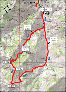
1. Hike or bike in Silver City - Try the Silver City Sawpit Peak Loop (8.5 mile hike; strenuous) or the Skyline Mine Tour (16.8 miles; advanced). Travel to Silver City via Nampa; take Idaho 45 to Walter's Ferry. Go left at the fork after crossing the Snake River and watch for the signed turnoff for Silver City on the right. It's about 20 miles to Silver City on paved and dirt roads. A high-clearance 4WD vehicle is best for the last 5 miles or so to the old mining burb. Even if the hike or ride sound like more than you'd like to bite off, go to Silver City and enjoy the yellow aspens and walk around town. You can take a hike up Jordan Creek south of town for several miles and climb to the ridge on two-track roads to a great overlook. This is the route for the Sawpit Peak Loop, but then it continues to wrap clockwise around the big mountain, descending back to Silver City via Sawpit Gulch. See detailed instructions in the Owyhee guidebook. There are multiple car-camping opportunities just north of Silver City.


2. Brown's Canyon Overland Tour - This is a nice, new 5.2-mile loop that circumnavigates the slot canyon hike in Brown's Canyon. You can look into the slot canyon without having to navigate the poison ivy, nettles, deep-water pools and thick brush. The hike starts and finishes in the Oreana area, west of Grand View. Rated moderate; travel time: 3+ hours. Getting there: Take I-84 to the Simco Road exit. Turn right on Simco Road and proceed to the state highway. Turn right at the highway and proceed to Grand View. Turn right on ID 78 in Grand View and then take the second left-hand turn to Oreana. Make a note of your odometer. Drive through the little town and go past the old church on the Oreana road until it takes a hard left. Make the corner and then take an immediate right on Alder Creek Road (no sign). Follow the road six miles to BLM Road 700. Turn right on 700 and drive to an old corral at a two-way junction. The hike  starts here. Continue west on BLM 700 and climb a moderate grade to a bluff that overlooks Browns Canyon. At mile 1.4, bear right on a two-track and drop into Brown's Creek draw. Walk down the draw until it begins to closeup in a blond slot canyon. Work to the left side of the draw and walk overland on the blond rocks staying above the draw. The canyon opens up at mile 2.0. Walk down the draw until the canyon closes up again, and then walk on the left rim of the canyon above the slot canyon. Walk around the small canyon when you come to that, and stay on the left rim until the slot canyon ends. Turn right on the dirt road at the end of the canyon at mile 3.6. Follow the road to a two-way junction at mile 4.0, turn right at a fence gate, and follow the two-track road BLM #710 back to the trailhead. Ending mileage is 5.2 miles. This hike would be great for kids and family. Bring sturdy shoes, plenty of water and a lunch.

3. Toy Pass - Two optional hikes take off from Toy Pass in the Owyhee Front, starting at 5,875 feet. Perfect for the fall! One hike is 5.3 miles exploring the mountain to the east of the pass, and the other is 4.5, exploring the small knob on the west side of the pass. Take I-84 to the Simco Road exit. Turn right on Simco Road and proceed to the state highway. Turn right at the highway and proceed to Grand View. Turn right on ID 78 in Grand View and then take the second left-hand turn to Oreana. Drive through the little town and go past the Basque church, then bear right on the signed Bachman Grade Road. Follow the well-maintained dirt road to the top of Toy Pass (about 13.5 miles). Park at the pass, and decide which mountain you'd like to climb from there.

4. Mary's Creek Canyon, south of Bruneau - Follow directions in a previous blog post on finding the Mary's Creek trailhead. This area is part of the Sheep Creek Wilderness on BLM land. The full loop is 8.75 miles, walking along the rim of Mary's Creek Canyon, dropping into the Sheep Creek Canyon, and then looping back to the trailhead. Travel time: 4-5 hours. You could do this as a backpacking trip and camp in Sheep Creek canyon. Be sure to pack your own drinking water and plenty of food.

5. Big Jack's Creek - The hike into Big Jack's from the Parker Trailhead is well east of the Soda burn zone, and it's a quick and easy way to get into the Big Jack's Wilderness, south of Bruneau. The directions, map and photos for this hike can be found in a previous blog post. It's 2.5 miles out and back. Rated moderate to strenuous (steep downhill into canyon; steep back out). Good hike for hikes and families.

Have fun!
- SS