Showing posts with label Mary's Creek. Show all posts

Thursday, March 17, 2022

Three Sweet Hikes that Shine in the Spring - Hells Canyon, Rapid River and Mary's Creek/Sheep Creek!

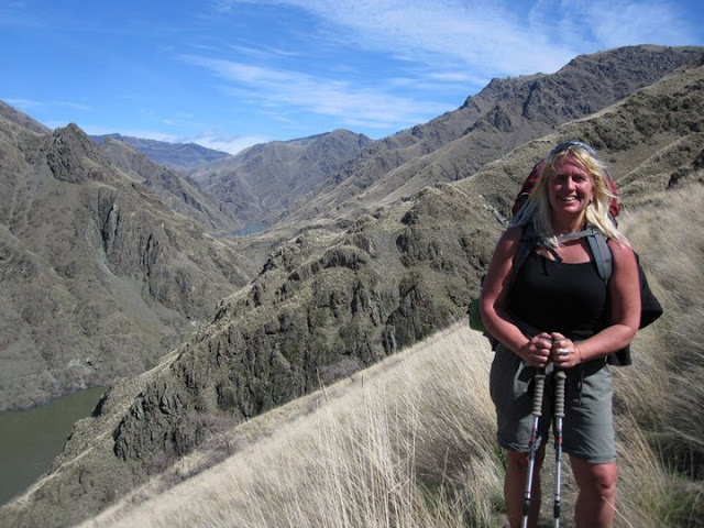
Denise Lauerman enjoys a spring backpack trip in Hells Canyon. 

Hi all, 

Spring is just four days away on Sunday, March 20, so the actual spring season according to the official American calendar is upon us. The trails and roads in the low country are beginning to dry out - in between rain storms - and the weather is warming up into the 60s at times. That gets people antsy for an outdoor adventure. 

For my outdoor tip of the week, I'm recommending three sweet hikes that shine in the spring in SW Idaho:

- Snake River National Recreation Trail in Hells Canyon, starting from Pittsburg Landing. 

- Rapid River Trail in Riggins. 

- Mary's Creek and Sheep Creek in the Bruneau River country.

The weather forecast for this weekend looks sunny on Friday with a high near 60, cloudy and rainy on Saturday, and then clearing and sunny on Sunday with a high of 50. That's the forecast for Boise and Riggins. Even if this weekend doesn't work to visit these destinations, you could wait and visit one of them at another time. 

Snake River National Recreation TrailA few years ago, I wrote about hiking or backpacking 6 miles (one way) from Pittsburg Landing to the Kirkwood Historic Ranch. A friend of mine, Denise Lauerman, and two of her friends backpacked to Kirkwood, and spent a couple of nights camping in Hells Canyon before returning to the trailhead in Pittsburg Landing. 

"It was a great trip -- I can't wait to go back," Denise said.

Hells Canyon, the deepest gorge in North America at over 7,000 feet, stradles the Idaho-Oregon border for more than 100 miles. The mighty Snake River flows through the heart of Hells Canyon and continues on to Lewiston. Hells Canyon is usually the warmest spot in Idaho, and it's also drier than many areas, so it's a good bet for a spring trip. Ditto in the fall. In the middle of the summer, it gets sizzling hot; hence, the name. The austere black rocky canyons also have contributed to the name.

The trip starts with a 4.5-hour drive from Boise to Pittsburg Landing, the trailhead, via ID 55 to New Meadows, U.S. 95 to Whitebird, and then a well-maintained, steep gravel road from Whitebird over Pittsburg Saddle to the trailhead at Lower Pittsburg Landing. Signs will guide you the whole way from Whitebird. Four-wheel-drive is not required.

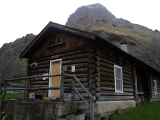
Kirkwood Museum 

It's 6 miles from the trailhead to Kirkwood Ranch. Denise and her friends drove in on a Friday, backpacked to Kirkwood in the afternoon (allow 2.5-3 hours travel time) and base-camped on the grass next to the Kirkwood Museum, where former Idaho Gov. Len B. Jordan and his wife, Grace, ran a sheep ranch in the 1930s.

The museum is definitely worth visiting. Behind the ranch, there is a two-track gravel road that climbs Kirkwood Creek for more than 3,000 feet to a high saddle. This is a great side-hiking opportunity that Denise and her friends climbed on Day 2, seeing all kinds of cool wildlife and landscapes along the way.

On Day 3, they side-hiked to Suicide Point along the Snake River, came back to Kirkwood, strapped on their backpacks, and hiked out. Suicide Point provides great views of the river canyon.

For more information, go to the Hells Canyon National Recreation Area web site. You can purchase maps at the Hells Canyon NRA office in Riggins.

See the full post Hells Canyon hiking 

Rapid River Trail (courtesy Hiking Project

Rapid River Trail in Riggins

This is a beautiful hike along Rapid River when things are greening up and coming to life in Riggins. Here's a description from All Trails. Full length is 8.6 miles out and back. You may not be able to go to the top of the hike, but you could likely hike a couple of hours to a high point that works for you. The trail winds along the river and then climbs up on a high ridge. Great views of the surrounding area. 

Trailhead is next to the Rapid River Hatchery on the south end of Riggins. Watch for signs on U.S. 95 to the hatchery.

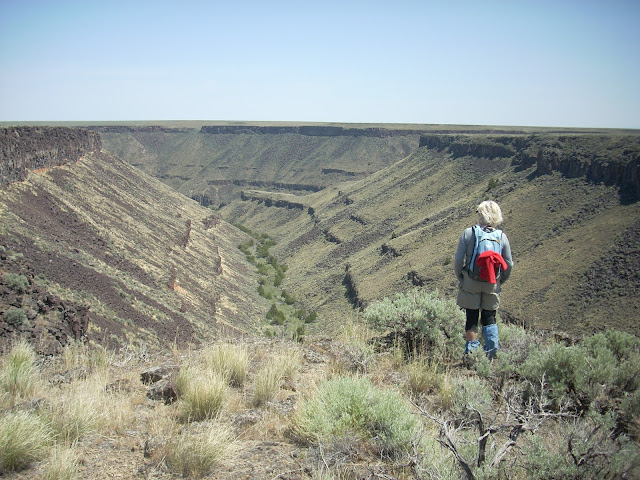
Barb Cochran looks into Mary's Creek canyon, a tributary of Sheep Creek.

Mary's Creek and Sheep Creek
 

Mary's Creek is one of the easiest places to access in the Jarbidge-Bruneau Wilderness. You can do a 8.75-mile loop hike from the Mary's Creek Trailhead to Sheep Creek canyon and back. The route I recommend in my Owyhee Canyonlands book takes you along the edge of Mary's Creek canyon, which features large black lava rock,  and then you drop quickly into Sheep Creek canyon (rhyolite and basalt) where you can have lunch or camp out next to the creek. And then retrace your tracks back to the trailhead. 

You also can camp at the Mary's Creek trailhead or in other BLM dispersed camping areas off the Roland Road.

Getting there: Take I-84 to Mountain Home, then Idaho 51 to Bruneau. Head south on Idaho 51 toward Duck Valley. It's about 40 miles from Bruneau to the signed turnoff for Roland Road on the left side, just past the old bar and junk yard in Grasmere. Go left on Roland Road and take that good-quality gravel road 5.2 miles to Mary's Creek Wilderness trailhead. 

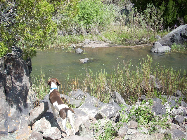
Huck checks out Sheep Creek. 

- SS

Thursday, October 14, 2021

Two must-do hiking trips in the Owyhee Canyonlands, plus Black Magic Canyon near Shoshone

Leslie Gulch - an otherworldly place! (photo by SS)

Hi all, 

It's been cold this week and snowy in the mountains, but it's warming up this weekend with high temperatures forecast in the high 60s in the valleys, maybe low 70s in the middle of the afternoon. 

For my outdoor tip of the week, I'm recommend three must-do desert hiking trips destinations in SW Idaho - Leslie Gulch and Mary's Creek/Sheep Creek in the Owyhee Canyonlands, and Black Magic Canyon near Shoshone. 

All three of these destinations should be perfect this weekend. 

1. Black Magic Canyon is a totally unique experience in a incised basalt canyon formed by the Big Wood River below Magic Reservoir. The jumble of black rocks inside the canyon have formed interesting shapes from wind, water and time. 

The Twin Falls Times-News provides an excellent write-up about visiting the canyon along with some great scenic pics by photographer Drew Nash and video. 

Fall and winter are the best times to visit this gem when it's dry. In the spring and summer months, it fills with water runoff and the unique rock formations are not visible.  

Photo by Drew Nash, Fly Photography


Please see the Times-News article for directions to Black Magic Canyon. Coming from the Treasure Valley, you'll want to take I-84 to the Gooding exit and take US 26 to Shoshone. Then, head north on US 93 and following the directions from there.

Southern Idaho Tourism also has a write up on the canyon as does Trip Advisor


We did a hike after a recent small burn ... interesting contrast! (photo by SS)

2. Leslie Gulch is a popular destination on the Oregon side of the Owyhee Canyonlands because it's one of the most scenic areas in the whole canyonlands complex. There are camping areas and rest rooms in Leslie Gulch, several different hiking opportunities and a hot springs near the boat ramp on Owyhee Reservoir. I detailed one hike in my Owyhee Canyonlands book that goes up Juniper Gulch to great overview on Yellowjacket mountain. It's 5.5 miles out and back. 

The area features a lot of rock formations that might remind you of Southern Utah -- redrock spires, hoodoos, honeycombs and more. It's just a cool place to see and explore. If you want to see less people, go during the work week. 

Here's a previous post on Leslie Gulch with details on how to get there and more. 

3. Another worthy destination this weekend would be to visit Mary's Creek and Sheep Creek Canyon, south of Bruneau. Sheep Creek canyon would be dry or maybe you'd see a few puddles right now. So that means you can hike down the canyon and explore. Mary's Creek and Sheep Creek are tributaries of the Bruneau River. They also are part of the Owyhee Canyonlands Wilderness. 


Mary's Creek in the springtime. See my truck by the trailhead?

Sheep Creek canyon in the springtime.

Here's a previous post that I did about this hike with driving directions to the trailhead. Enjoy! 

Map of Mary's Creek hike to trail dropping into Sheep Creek canyon. It's possible to drive that two-track jeep trail to the canyon rim if you've got a good 4WD high-clearance vehicle.

- SS

Thursday, April 27, 2017

Weather warming up this weekend and next week! Time to head for the Owyhees!

Jim Giuffre, foreground, Steve Schneider and Doug Lawrence just finishing the China Ditch Trail ... 
Sheep Creek Canyon cuts through old rhyolite lava rock 
Stopping to enjoy the grandeur of Reynolds Creek canyon. 

Hi all, 

The forecasts are predicting that we'll get a break from the rain this weekend, and next week the temperatures might hit 70 degrees F! OMG! Time to head out for a spring hike or bike ride in the Owyhees! Maybe take your camping gear and stay overnight? 

I just completed a 3rd printing of The Owyhee Canyonlands - An Outdoor Adventure Guide, so I've got plenty of books on hand if you haven't purchased your copy yet. The books are available on my web site, stevestuebner.com, Boise REI, Idaho Mountain Touring, Owyhee County Museum gift shop in Murphy, and Amazon

For this week's outdoor tip, I'll dish up two hikes and one mountain bike ride in the Owyhees. 

John Wheaton, Amy Haak, Wendy and me on
a winter ride on Bingo's Trail. 
First, the bike ride - the Wilson Creek - Northwest Passage Loop. Distance: 16.25 miles; travel time: 3.5-4 hours; vertical gain: 2,075 feet. Rated strenuous. Mountain bikers love this ride. It's almost all singletrack with a couple of short sections of two-track road. The Soda fire did a number on Reynolds Creek canyon, which some people feel has diminished the scenery. But I still think it's a great ride. 

See my blog post with photos, a map and blow-by-blow directions of the ride

Now, the hikes: 

1. Wilson Creek-Reynolds Creek Loop - Distance 7.4 miles; travel time: 3.5 hours; vertical gain: 750 feet; Rated moderate to stenuous ... mostly moderate. This is a shorter version of the Northwest Passage loop. Getting there: From downtown Boise, take I-184 west to Nampa. Take the Franklin Road exit (City Center) in Nampa, and turn left. Follow Franklin to the intersection with 11th Street. Turn right and take 11th into downtown Nampa. Follow signs for Idaho 45 south. Take ID 45 to Walters Ferry at the Snake River and turn right on ID 78, heading for Marsing. In a couple miles, turn left on Wilson Creek Road. Proceed up the paved road, past the cattle feedlot, until it turns to dirt and pull into a dirt parking area on the left, the trailhead for Trail #300. The hike starts here.

This is a great hike (good for trail-running, too) in the foothills of the Owyhee Mountains, about 45 minutes from Boise. The trail weaves through rock formations on the way over to Reynolds Creek, and then you hike the China Ditch trail along Reynolds Creek. The red rock canyon is spectacular. Bring your camera, plenty of water and a lunch. Even though the route is 7+ miles, the elevation gain is pretty minimal, so the hike may be suitable for kids 8 and over. My kids enjoyed the hike, especially throwing rocks into the creek.

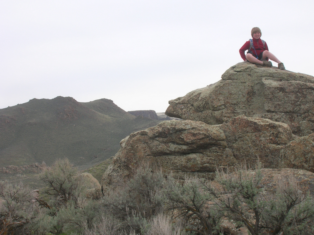
Quinn hangs out on a big rock 
Directions: To begin, pick up Trail #300 out of the parking lot. Ignore trails branching off to the left in the first mile. At mile .9, you’ll cross a road and continue on the singletrack trail. The trail climbs one last hill and then widens into a two-track and descends to a T-junction at a dirt road (mile 1.8). Go right for a short bit, and turn left on Trail #410, a sandy wash going downhill towards Reynolds Creek. At mile 2.3, go right on Trail #310 and proceed for a half mile to a junction with Trail #600, the China “Ditch” trail. Go right and walk upstream along Reynolds Creek canyon for a long mile. After walking next to vertical rock walls, the trail opens up on the right at the junction with Trail #510, #601 and #610. Go right on #510 and climb out of the canyon. At mile 4, bear right at a Y junction on #510 and stay on #510 to BLM dirt road #37154. Go right and follow the road to the junction with Trail #400. Go left on #400 at mile 5.28 and head back to the trailhead. At the top of the first hill, you can either stay on Trail #400 or branch off on #300. Both ways head over to the Wilson Creek Road and the trailhead.

Sheep Creek canyon is deep! 
2. Mary's Creek to Sheep Creek Canyon - Distance: 8.75 miles; travel time: 4-5 hours; Vertical gain: 1,389 feet; Rated moderate to strenuous. This is a neat hike that takes you over to the deep incised canyon of Sheep Creek, where it's possible to camp by the creek or certainly stop and have lunch there before you head back. Mary's Creek also lies inside a BLM wilderness area, so this is a hiking-only experience. 

Road access: Easy, any kind of 2WD vehicle will work to reach this trailhead. 

Getting there: From Boise, take I-84 east to Mountain Home. Take the first exit to downtown Mountain Home. Proceed through town and watch for Idaho 51 to Bruneau. Turn left on Idaho 51 and go to Bruneau. Pick up any last-minute snacks/beverages and head south on Idaho 51. Check your odometer when you leave Bruneau. It's about 40 miles from Bruneau to the signed turnoff for Roland Road on the left, just past the old bar and junk yard in Grasmere. Go left on Roland Road, and take that good-quality gravel road 5.2 miles to the signed Mary's Creek Wilderness Trailhead. The hike starts here.   

General remarks: Mary's Creek is one of the more easy-to-access trailheads in the Sheep Creek/Bruneau Wilderness area. It's a scenic basalt canyon that drains into the much-deeper and spectacular box canyon of Sheep Creek. It's possible to do either a day trip here, or take a backpack and camp overnight at the Mary's Creek/Sheep Creek confluence, do some exploring and enjoy some quiet peace of mind. The day hike features a cross-country walk along the edge of Mary's Creek canyon for 3+ miles to the edge of the canyon rim. Then, there's a nice little singletrack hiking trail, called the Tindall Trail, that drops down to the confluence area, where there are several areas large enough for a campsite. We returned to the Mary's Creek Trailhead via a rough and rocky two-track road, just to make the walking a little easier. The two-track is drivable with a high-clearance 4WD rig, outside the wilderness boundary, if you want to drive directly to the canyon rim. I'd recommend this hike for kids who are 8-10 years old and up.       

Directions: To start, hike through the sagebrush along the left side of Mary's Creek canyon. It will get considerably deeper as you approach Sheep Creek canyon. At mile 3.6, you'll arrive at the canyon rim, where you'll see a singletrack trail winding through the rocks down to the Mary's Creek/Sheep Creek confluence. It's .7 miles and 520 feet of descent from the rim to the confluence. Great spot for lunch or overnight camping. Retrace your steps to the canyon rim, and take the two-track road back to the trailhead. Final mileage is 8.75 miles.

Have fun! Hoping for sunshine all weekend! 
- SS 

Thursday, September 24, 2015

Explore five hikes in the Owyhee Mountains; Colors should be fab in Silver City!

Wendy and Huck in  a January hike in Brown's Canyon 
Wendy soars in a brisk wind on top of a mountain above Toy Pass
Great skyline views from the mountains above Toy Pass
The quakies should be golden in Silver City 
High on the saddle overlooking Silver City and surrounding area ... 
Sheep Creek canyon ... you'll have it to yourself. 
Gearing up for our ride in Silver City. 
Hi all,

It looks as if it's going to be a beautiful late September weekend in SW Idaho, with daytime highs in the low 80s and night-time temps in the high 40s or low 50s, depending on elevation. It'll be a great weekend for hiking, biking or camping in the Owyhee Canyonlands.

I've been thinking a lot about the Owyhees lately because of the 285,000-acre Soda Fire, and the subsequent recreation closure of multiple trailheads in the Owyhee Front. I also am giving a REI clinic on exploring the Owyhees next Wednesday at 7 p.m. (still openings available at press time), and I've been checking into the extent of the burn zone to share with folks who want to know!

So for my outdoor tip this week, I'll detail five places to go outside of the burn zone. Keep these in mind for the coming weeks in October as well. All of the trips are drawn from The Owyhee Canyonlands: An Outdoor Adventure Guide. 

Also, Avimor is hosting their fall Demo Days event from 10 a.m. to 4 p.m. on Saturday. There will be show-me rides, food, music and beer. The event provides a great chance to demo various new mountain bikes on the market. George's peeps said that demo trucks from Trek and Specialized will be there with 2016 models for people to test out. Idaho Mountain Touring, Ridgeline Sports, Broken Spoke, Kore North and Boise Bike Wrench will be there with more bikes to demo as well!

Now, back to the Owyhees ... See the burn map below for a big-picture view of the Soda Fire burn zone (click to enlarge):
Soda fire perimeter
Generally, the Owyhee Front between U.S. 95 and Reynolds Creek Road all lies inside the burn zone and the Bureau of Land Management is asking for recreationists to stay off these lands this fall. These areas include Jump Creek Canyon, Wildcat Canyon, Squaw Creek, and Wilson Creek. Areas around Silver City were left unscathed.

In Eastern Oregon, the fire spread to points east of the Succor Creek Road, but none of it crossed Succor Creek itself or the road, leaving everything to the west in good shape, including Three Fingers, Sage Creek, Painted Canyon, Carlton Canyon, the Honeycombs, Leslie Gulch, etc.

So here are my 5 recommendations for the weekend:
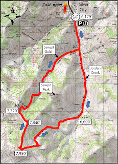
1. Hike or bike in Silver City - Try the Silver City Sawpit Peak Loop (8.5 mile hike; strenuous) or the Skyline Mine Tour (16.8 miles; advanced). Travel to Silver City via Nampa; take Idaho 45 to Walter's Ferry. Go left at the fork after crossing the Snake River and watch for the signed turnoff for Silver City on the right. It's about 20 miles to Silver City on paved and dirt roads. A high-clearance 4WD vehicle is best for the last 5 miles or so to the old mining burb. Even if the hike or ride sound like more than you'd like to bite off, go to Silver City and enjoy the yellow aspens and walk around town. You can take a hike up Jordan Creek south of town for several miles and climb to the ridge on two-track roads to a great overlook. This is the route for the Sawpit Peak Loop, but then it continues to wrap clockwise around the big mountain, descending back to Silver City via Sawpit Gulch. See detailed instructions in the Owyhee guidebook. There are multiple car-camping opportunities just north of Silver City.


2. Brown's Canyon Overland Tour - This is a nice, new 5.2-mile loop that circumnavigates the slot canyon hike in Brown's Canyon. You can look into the slot canyon without having to navigate the poison ivy, nettles, deep-water pools and thick brush. The hike starts and finishes in the Oreana area, west of Grand View. Rated moderate; travel time: 3+ hours. Getting there: Take I-84 to the Simco Road exit. Turn right on Simco Road and proceed to the state highway. Turn right at the highway and proceed to Grand View. Turn right on ID 78 in Grand View and then take the second left-hand turn to Oreana. Make a note of your odometer. Drive through the little town and go past the old church on the Oreana road until it takes a hard left. Make the corner and then take an immediate right on Alder Creek Road (no sign). Follow the road six miles to BLM Road 700. Turn right on 700 and drive to an old corral at a two-way junction. The hike  starts here. Continue west on BLM 700 and climb a moderate grade to a bluff that overlooks Browns Canyon. At mile 1.4, bear right on a two-track and drop into Brown's Creek draw. Walk down the draw until it begins to closeup in a blond slot canyon. Work to the left side of the draw and walk overland on the blond rocks staying above the draw. The canyon opens up at mile 2.0. Walk down the draw until the canyon closes up again, and then walk on the left rim of the canyon above the slot canyon. Walk around the small canyon when you come to that, and stay on the left rim until the slot canyon ends. Turn right on the dirt road at the end of the canyon at mile 3.6. Follow the road to a two-way junction at mile 4.0, turn right at a fence gate, and follow the two-track road BLM #710 back to the trailhead. Ending mileage is 5.2 miles. This hike would be great for kids and family. Bring sturdy shoes, plenty of water and a lunch.

3. Toy Pass - Two optional hikes take off from Toy Pass in the Owyhee Front, starting at 5,875 feet. Perfect for the fall! One hike is 5.3 miles exploring the mountain to the east of the pass, and the other is 4.5, exploring the small knob on the west side of the pass. Take I-84 to the Simco Road exit. Turn right on Simco Road and proceed to the state highway. Turn right at the highway and proceed to Grand View. Turn right on ID 78 in Grand View and then take the second left-hand turn to Oreana. Drive through the little town and go past the Basque church, then bear right on the signed Bachman Grade Road. Follow the well-maintained dirt road to the top of Toy Pass (about 13.5 miles). Park at the pass, and decide which mountain you'd like to climb from there.

4. Mary's Creek Canyon, south of Bruneau - Follow directions in a previous blog post on finding the Mary's Creek trailhead. This area is part of the Sheep Creek Wilderness on BLM land. The full loop is 8.75 miles, walking along the rim of Mary's Creek Canyon, dropping into the Sheep Creek Canyon, and then looping back to the trailhead. Travel time: 4-5 hours. You could do this as a backpacking trip and camp in Sheep Creek canyon. Be sure to pack your own drinking water and plenty of food.

5. Big Jack's Creek - The hike into Big Jack's from the Parker Trailhead is well east of the Soda burn zone, and it's a quick and easy way to get into the Big Jack's Wilderness, south of Bruneau. The directions, map and photos for this hike can be found in a previous blog post. It's 2.5 miles out and back. Rated moderate to strenuous (steep downhill into canyon; steep back out). Good hike for hikes and families.

Have fun!
- SS
Thursday, May 1, 2014

Here are three off-the-beaten-trail spring camping tips in the Owyhee Canyonlands

The Owyhee Uplands Backcountry Byway can be fun for mountain biking, too ...
Photo courtesy Tad Jones 
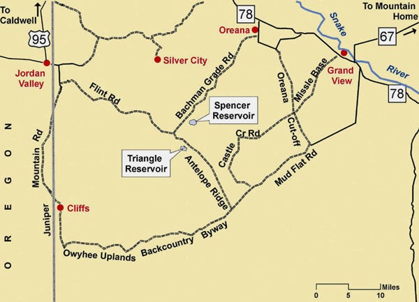
Big picture map of the byway
Toy Pass and vicinity ... Silver City is by the snow-packed mountains 
Wendy rides the wind currents on top of the mountains near Toy Pass 
Steve near the mouth of Mary's Creek 
Mary's Creek confluence in Sheep Creek 
You should see wildflowers this weekend ... Bring your plant guide! 
Hi all,

Well, the weather looks positively fabulous this weekend, so a lot of people have been asking me for some good ideas about spring camping in the Owyhees. First, you need to pick up our Owyhee Canyonlands guidebook for the most in-depth information. But here in my outdoor tip of the week, I'll share three ideas from the book that are family friendly and pretty easy to find.

In today's Idaho Statesman, the IdahoOutdoors team highlighted some excellent scenic drives, hiking and camping destinations in the Owyhees, including Leslie Gulch, Succor Creek State Park, and Jordan Craters. The only issue is those places will be pretty popular and busy this weekend, so you might want to try something that's a little more off the beaten path.

Here are three that aim to please:
1. Drive the Owyhee Uplands Backcountry Byway and find your own custom spot to make camp. I recommend starting on the byway by Grand View, (Gus's gas stop has copies of our Owyhee Canyonlands guidebook), and driving south into the Owyhees to the top of the first summit. Turn left on the dirt road heading over to Little Jack's Creek, and find a cool spot to camp and hike. Be sure to take a BLM map with you so you can navigate the dirt roads. The backcountry byway has many other options for camping such as the Antelope Springs Road, Deep Creek junction, Nickel Creek Table and the North Fork of the Owyhee BLM campsite, the only developed campsite on the 100-mile byway. The byway is suitable for 2WD vehicles. Side roads may require 4WD.

2. Toy Pass - We've got 2 hikes from the Owyhee Canyonlands guidebook that start and finish at Toy Pass. This spot is at 5,875-foot elevation, south of Oreana. You drive to Toy Pass, do a day hike from the pass to the mountains on either side of the road, and then go look for a campsite afterwards. There's a sweet campsite in a pullout on the south side of Toy Pass, and there are other places to camp on the road farther south toward Triangle on BLM land. Again, bring a BLM map with you to navigate the roads. To reach Toy Pass, take ID 78 east from Walters Ferry, south of Nampa, go past Murphy and watch for a road sign for Oreana. Turn right and drive 2 miles into the tiny town. Bear right at Our Lady, Queen of Heaven Catholic Church at the corner, and take the Bachman Grade Road to Toy Pass. It's about 13.5 miles to the top. This road is suitable for 2WD vehicles. Side roads may require 4WD.

3. Mary's Creek/Sheep Creek Wilderness. Mary's Creek is an easy-to-access tributary of Sheep Creek Canyon, which is one of the BLM wilderness areas in the Owyhee Canyonlands. There is a self-support camping area at the "trailhead" next to Roland Road. You could camp there, and then do the Mary's Creek Loop, hiking into the bottom of spectacular Sheep Creek Canyon, and then hike back. You also could backpack into Sheep Creek Canyon and camp there. The full loop detailed in our guidebook is 8.75 miles, with 1,400 feet of vertical gain/loss. Scenic hike and nice spot to camp. To reach Mary's Creek, take ID 51 south of Bruneau about 40 miles to a signed turnoff for the Rowland Road by the old bar and junk yard at Grasmere. Turn left on Rowland Road and follow that 5.2 miles to the Mary's Creek trailhead. There's a BLM kiosk at the trailhead.

Watch for wildflowers while you're out there ... and bring a plant guide to help with identification. Here's one guide that I highly recommend -- the Backpack Guide to Idaho Range Plants.

There you have it! Enjoy the sunshine no matter what you do!
-SS