Showing posts with label Owyhee Backcountry Byway. Show all posts

Wednesday, May 15, 2019

Drive the Owyhee Uplands Backcountry Byway or hike two off-beat locations in the Owyhee Canyonlands

Sheep Creek below Mary's Creek ... very remote spot with plenty of solitude.

Huck checks out Sheep Creek
War Eagle Mountain can been seen in the distance behind Steve. Hiking to the west of Toy Pass is easy with big views.
Hi all,

The weather appears to be turning cool and moist heading into the weekend. Saturday looks like the most promising day to go hiking, with no chance of rain and a high of 65 degrees. Perfect conditions for a hike in the Owyhee Canyonlands!

For people in the know, the Owyhees are a great place to explore in the spring before the summer heat comes to SW Idaho and the rattlesnakes come out in the high desert. And if you don't know much about the Owyhees, you can pick up a copy of my Owyhee Canyonlands guidebook, which features 55 hiking and biking routes in the greater area, plus a guide to the Owyhee Uplands Backcountry Byway.
 
Here are three destinations:


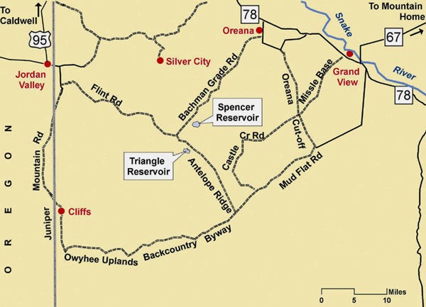
1. Drive the 100-mile Owyhee Uplands Backcountry Byway and enjoy a big-picture overview of the Owyhee Mountains and Owyhee Plateau. The drive can be done in a day. The byway has a good-quality dirt road that travels out into "The Big Wide Open" (no services, BTW) and eventually drops back to civilization in Jordan Valley, Oregon. I recommend starting on the byway in Grand View and traveling in a east-to-west direction to Jordan Valley. Pack a lunch, some beverages and enjoy the drive. The backcountry byway will pass many intriguing areas, such as the Antelope Springs Road, Deep Creek junction, Nickel Creek Table and the North Fork of the Owyhee BLM campsite, the only developed campsite on the 100-mile byway. The byway is suitable for 2WD vehicles. But make sure your spare tire is in good shape. Again, there are no services out there, and no mobile service.

Wendy pretends she's an eagle on top of the Owyhee Mountains near Toy Pass. Bachman Grade Road can be seen below. 
2. Toy Pass - I've got 2 hikes in the Owyhee Canyonlands guidebook that start and finish at Toy Pass, accessed from the Bachman Grade Road, south of the little town of Oreana, between Murphy and Grand View in the Owyhee Front. Toy Pass sits at 5,875-foot elevation, south of Oreana. Drive to Toy Pass, do a day hike from the pass to the mountains on either side of the road, and then either go look for a campsite afterwards or head back home. To reach Toy Pass, take Simco Road to Grand View. Go right on ID 78 in Grand View and travel west to Oreana. Watch for a road sign for the historic Owyhee town. Turn left and drive 2 miles into town. Bear right at Our Lady, Queen of Heaven Catholic Church at the corner, and take the Bachman Grade Road to Toy Pass. It's about 13.5 miles to the top. This road is suitable for 2WD vehicles. Park at the pass and decide which mountain you'd like to climb. See maps below for hiking to the west or to the east. Both routes are about 5 miles.


Map courtesy of Owyhee Canyonlands: An Outdoor Adventure Guide.

3. Mary's Creek/Sheep Creek Wilderness. Mary's Creek is an easy-to-access tributary of Sheep Creek Canyon, which is one of the BLM wilderness areas in the Owyhee Canyonlands. There is a self-support camping area at the "trailhead" next to Roland Road. You could camp there, and then do the Mary's Creek Loop, hiking into the bottom of spectacular Sheep Creek Canyon, and then hike back. You also could backpack into Sheep Creek Canyon and camp there. The full loop detailed in our guidebook is 8.75 miles, with 1,400 feet of vertical gain/loss. Scenic hike and nice spot to camp. To reach Mary's Creek, take ID 51 south of Bruneau about 40 miles to a signed turnoff for the Rowland Road by the old bar and junk yard at Grasmere. Turn left on Rowland Road and follow that 5.2 miles to the Mary's Creek trailhead. There's a BLM kiosk at the trailhead.


Views of Sheep Creek from the rim above.
Map of the Mary's Creek Loop
There you have it!
-SS

Thursday, May 1, 2014

Here are three off-the-beaten-trail spring camping tips in the Owyhee Canyonlands

The Owyhee Uplands Backcountry Byway can be fun for mountain biking, too ...
Photo courtesy Tad Jones 
Big picture map of the byway
Toy Pass and vicinity ... Silver City is by the snow-packed mountains 
Wendy rides the wind currents on top of the mountains near Toy Pass 
Steve near the mouth of Mary's Creek 
Mary's Creek confluence in Sheep Creek 
You should see wildflowers this weekend ... Bring your plant guide! 
Hi all,

Well, the weather looks positively fabulous this weekend, so a lot of people have been asking me for some good ideas about spring camping in the Owyhees. First, you need to pick up our Owyhee Canyonlands guidebook for the most in-depth information. But here in my outdoor tip of the week, I'll share three ideas from the book that are family friendly and pretty easy to find.

In today's Idaho Statesman, the IdahoOutdoors team highlighted some excellent scenic drives, hiking and camping destinations in the Owyhees, including Leslie Gulch, Succor Creek State Park, and Jordan Craters. The only issue is those places will be pretty popular and busy this weekend, so you might want to try something that's a little more off the beaten path.

Here are three that aim to please:
1. Drive the Owyhee Uplands Backcountry Byway and find your own custom spot to make camp. I recommend starting on the byway by Grand View, (Gus's gas stop has copies of our Owyhee Canyonlands guidebook), and driving south into the Owyhees to the top of the first summit. Turn left on the dirt road heading over to Little Jack's Creek, and find a cool spot to camp and hike. Be sure to take a BLM map with you so you can navigate the dirt roads. The backcountry byway has many other options for camping such as the Antelope Springs Road, Deep Creek junction, Nickel Creek Table and the North Fork of the Owyhee BLM campsite, the only developed campsite on the 100-mile byway. The byway is suitable for 2WD vehicles. Side roads may require 4WD.

2. Toy Pass - We've got 2 hikes from the Owyhee Canyonlands guidebook that start and finish at Toy Pass. This spot is at 5,875-foot elevation, south of Oreana. You drive to Toy Pass, do a day hike from the pass to the mountains on either side of the road, and then go look for a campsite afterwards. There's a sweet campsite in a pullout on the south side of Toy Pass, and there are other places to camp on the road farther south toward Triangle on BLM land. Again, bring a BLM map with you to navigate the roads. To reach Toy Pass, take ID 78 east from Walters Ferry, south of Nampa, go past Murphy and watch for a road sign for Oreana. Turn right and drive 2 miles into the tiny town. Bear right at Our Lady, Queen of Heaven Catholic Church at the corner, and take the Bachman Grade Road to Toy Pass. It's about 13.5 miles to the top. This road is suitable for 2WD vehicles. Side roads may require 4WD.

3. Mary's Creek/Sheep Creek Wilderness. Mary's Creek is an easy-to-access tributary of Sheep Creek Canyon, which is one of the BLM wilderness areas in the Owyhee Canyonlands. There is a self-support camping area at the "trailhead" next to Roland Road. You could camp there, and then do the Mary's Creek Loop, hiking into the bottom of spectacular Sheep Creek Canyon, and then hike back. You also could backpack into Sheep Creek Canyon and camp there. The full loop detailed in our guidebook is 8.75 miles, with 1,400 feet of vertical gain/loss. Scenic hike and nice spot to camp. To reach Mary's Creek, take ID 51 south of Bruneau about 40 miles to a signed turnoff for the Rowland Road by the old bar and junk yard at Grasmere. Turn left on Rowland Road and follow that 5.2 miles to the Mary's Creek trailhead. There's a BLM kiosk at the trailhead.

Watch for wildflowers while you're out there ... and bring a plant guide to help with identification. Here's one guide that I highly recommend -- the Backpack Guide to Idaho Range Plants.

There you have it! Enjoy the sunshine no matter what you do!
-SS

Thursday, October 17, 2013

Fall colors are popping throughout the mountains of Idaho; take a drive on our lovely scenic byways

Here's Wendy hiking along Jordan Creek in Silver City
Aspens glowing in the Sawtooth Valley by Ed Cannady
Fall colors in the Caribou-Targhee National Forest (courtesy US Forest Service)
Fall colors in the Sawtooths (courtesy explore.org)
Wood River Valley (courtesy SunValleyrents.com)
Hi all,

The fall colors are just beginning to happen in the Treasure Valley. But in the mountains, the aspen trees are turning yellow and orange, the tamarack needles are turning yellow, the shrubs are turning orange and red, and this weekend would be a perfect time to go for a scenic drive -- and maybe a side-hike -- to enjoy the kaliedoscope of colors.

So where are you going to go? Start by taking a look at the Idaho Scenic Byways web site, providing by our friends at VisitIdaho. There are now a total of 30 official scenic byways that you can explore in statewide. The drives that I'd recommend include:

  • The Sawtooth Scenic Byway - This byway runs from Shoshone to Stanley on Idaho 75. You'll see the cottonwood trees turning color along the Big Wood River, and then things really get brilliant with the aspen trees in the Ketchum/Sun Valley area. Consider a side hike in Adams Gulch on the left side of the road, just north of Ketchum. Check out the Sun Valley web cams for a sneak-peek. Going north, you'll see some beautiful aspen groves in the Boulder Mountains on the right side of the road. And then the byway continues north over Galena Summit, where you'll be treated to a huge view of the Sawtooth Valley, the headwaters of the Salmon River, the Sawtooth Wilderness on the left, and the White Cloud Mountains on the right.
  • The Ponderosa Pine Scenic Byway - Follows Idaho 21 from Boise to Idaho City to Lowman to Stanley. You'll see a cornucopia of colors in the Boise National Forest, with a menagerie of yellows, oranges and reds in the shrubs and underbrush below the stately ponderosa pine trees between Idaho City and Lowman. You'll see some pretty groves of aspens as you get closer to Stanley. Stop by Stanley Lake Campground to enjoy the views. 
  • Do a big combination loop by driving the Ponderosa Pine byway to Stanley and then follow the Sawtooth byway to Ketchum/Sun Valley and return to Boise via U.S. 20. Allow a full day to complete this drive, or break it up by staying overnight in Stanley or Ketchum/Sun Valley. 
  • The Payette River Scenic Byway - This is a familiar drive for many from Boise to McCall, but it won't disappoint when it comes to fall colors. On this route, you'll see tamarack or western larch trees turning yellow by the time you reach Smith's Ferry and onward to McCall and Payette Lake. Plus, you'll see lots of colorful shrubs in the Boise National Forest along the way and isolated aspen groves here and there. Check the McCall web cams for a sneak-peek for the lake view. Take a side hike in Ponderosa State Park once you're in McCall. You'll see lots of colors in the park.  
  • The Owyhee Backcountry Byway - This is a more adventurous scenic drive because it involves 85 miles of dirt road between the paved portals of Grand View and Jordan Valley, OR. But it is truly a scenic drive into the Owyhee Mountains and Canyonlands. You'll cottonwoods and aspens throughout the route. Bring plenty of food and water because there are no services along the route. Allow a full day for the drive. Expect to encounter hunters in vehicles and ATV's along the way.  
  • Murphy to Silver City - Wendy and I went hiking in Silver City on Tuesday, and the cottonwoods and aspens were peaking a brilliant yellow along Jordan Creek. It's about two hours from Boise to Silver City. Take Idaho 45 south of Nampa to Murphy, and then watch for a signed turnoff to Silver City east of Murphy. The road is paved for a while, and then it turns to dirt. A high-clearance vehicle is needed to navigate the bumpy, rocky road to Silver City. As you drop down from the pass into Silver City, turn left at a Y-junction by the ATV parking area and rest room, and then proceed through town to a BLM parking area and rest room. Take a walk up Jordan Creek to stretch your legs. Bring your own food and water. The Silver City Hotel may or may not be open on the weekend, and it's closed during the week. 
---------------------------------------
Couple of things going on this weekend that I recommend:

SWIMBA Member Appreciation Party and Group Ride Saturday from 3-9 p.m. Meet at Joe's Crab Shack at 3 p.m. There will be a bike ride to Mulligans from 3:30 - 5  p.m. It's SWIMBA's 21st birthday party, election of officers, and all of that good stuff.

"Elevation" movie premier at Idaho Mountain Touring, 8 p.m. at Idaho Mountain Touring, 13th and Main, downtown Boise.