Showing posts with label Garden Valley. Show all posts

Thursday, April 28, 2022

Middle Fork Payette-Garden Valley hikes opening up for spring!

Station Creek winds through ponderosa pines on the way up a long ridge. 

Hi all, 

Wendy and I thought we'd hike the lovely Station Creek Trail in Garden Valley last Saturday to enjoy a 6-mile day hike in a forested setting. 

We were delighted to see the lower-elevation mountains in Garden Valley greening up for springtime recreation. We didn't encounter any snow on our hike up Station Creek Trail to the initial high point and saddle, or on the way up to Bald Mountain - another mile farther and an extra 500 feet of elevation gain. 

We dodged small squalls that were happening from time to time, but generally, it was a perfect day for spring hiking, with cool temps in the high 40s to low 60s, depending on the moment. 

If Station Creek Trail is in prime shape for hiking, then I'd also recommend two other nice hikes nearby - One Spoon and Lightning Ridge Trails. I've blogged about all three before. 
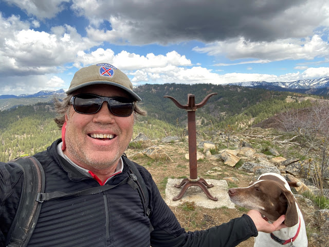
Steve and Huck on top of Bald Mountain ... elk sign everywhere! 

So that's my outdoor tip of the week - go check out any one of those three trails and enjoy hiking in a forested setting with creek water flowing below, wildflowers and shrubs beginning to bloom, and maybe even some morels popping up if you're lucky! 

The Trailhead for Station Creek is directly across from the Banks-Lowman Highway from the Garden Valley Ranger Station. It takes about an hour to get there from Boise. You can stop at the Garden Valley Chevron for any last-minute supplies before you head for the trailhead. 

Travel time on the Station Creek is about 5-6 hours, out and back. It's shorter if you just go to the initial high point about 2 miles up the trail. I rate the hike "moderate to strenuous" because there are some short, strenuous pitches.

Lunch on a big slab of granite near the top of the One Spoon hike with Wendy, Mark and Laurie. 

One Spoon Trail - Click on a previous post where I wrote about hiking One Spoon, including a map and driving directions, and also tips on floating the Middle Fork Payette River, Tie Creek section. The hike is 6 miles round-trip with up to 2,600 feet of vertical gain. You'll walk through ponderosa pine trees and see lots of cool big granite rocks along the way.  
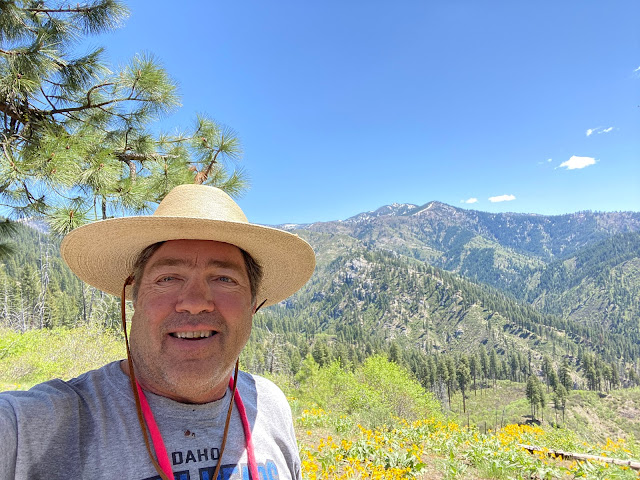
Lightning Ridge affords vast views of the Boise National Forest

Lightning Ridge Trail - Wendy and I hiked Lightning Ridge Trail last spring. This trail goes for quite a ways, so the distance is kind of up to you. We went about three miles up the trail to an initial high point, turned around and came back to the trailhead. 

Difficulty: Moderate to strenuous

Driving directions: Take ID 55 to Banks. Go left in Banks and take the Banks to Lowman Road to the Crouch turnoff. Head up the Middle Fork Payette River Road (USFS #698) to a marked junction with USFS Road #611, the Lightning Creek Road, on the right. Follow the dirt road about five miles to the trailhead where an earthen barrier prevents further vehicular traffic. 

Have a great time exploring these trails! Bring a lunch and plenty of water for your day trip.   

Both Station Creek and One Spoon are featured in my guidebook, "Boise Trail Guide: 95 Hiking and Running Routes Close to Home." 

- SS 

Thursday, May 9, 2019

Try floating the tranquil Middle Fork Payette River as a relaxing alternative to whitewater

Idyllic scene on the Middle Fork Payette River, Laurie Anderson, Cymry Reed, Joanie Faucie and Wendy in Big Red.
Hi all,

I'm sure everyone is enjoying the fabulous weather, and this weekend should be incredible with temperatures in the 80s! 

With warm weather, our whitewater rivers will be rising as the deep snowpack melts in the mountains. The white-knuckle whitewater enthusiasts will be out on the South Fork Payette River and North Fork Payette for an adrenaline-charged experience.

Last Sunday, we decided to go for a more low-key experience on the Middle Fork of the Payette River, near Crouch in Garden Valley. This is an often-overlooked river trip at this time of year, but right now, the flows are perfect for Stand-Up Paddle-Boarding (SUP), canoeing, inflatable kayaking, sit-on-top kayaks, and rafting. There are no rapids, but many bends in the river, so that is your main navigational challenge. Might be a good call for a Mother's Day float!

More of our crew, Mishel, Jim and Pam from McCall, and Mark Anderson on the SUP
It's an 8-mile reach that starts at Tie Creek Campground, about nine miles north of Crouch, and flows by a diverse array of cabins and shacks on the river bank, with forested mountains in the distance. It's a very scenic float trip, plus it's fun to check out the cabins. It takes about 3 hours to do the float. Take your time, bring a lunch and enjoy the trip. 

The river flow is increasing a bit toward 2,000 cfs. That is a sweet level!  

Plant a shuttle vehicle in Crouch at the take-out before you go, or have friends pick you up. There is a detailed description and map about this day trip in my guidebook, Paddling the Payette, a guide to 24 day trips on the Payette River. The book is available at Idaho River Sports and Alpenglow Mountainsport. 

We did lunch at Mishel's cabin on the Middle Fork.
If you've got the time, bring your camping gear and hang out in the Middle Fork area. There are numerous car-camping spots along the Middle Fork ... some are developed campgrounds with water and fire pits, etc., and some are less developed. I am not sure if the Forest Service campgrounds are open yet. You also could stay at a bed & breakfast or the Garden Valley Hotel. See the Garden Valley Chamber of Commerce for more information on lodging. 
The other thing to consider when you're in Crouch is to visit the Longhorn Restaurant & Saloon. I love their burgers. The Longhorn has 16 different beers on tap. You also could play a round of scenic golf at the Terrace Lakes Resort, or eat dinner at Terrace Lakes. The food is good and prices are reasonable. Other activities in the area include numerous hot springs, both primitive and developed.

Waving to folks at their cabins along the way
Have fun!
- SS

Thursday, May 3, 2018

Station Creek hike is a primo option in May - it's bursting with wildflowers and very green

On top of 5,122-foot Bald Mountain with its weird lightning-rod thingy marking the summit. 
Arrowleaf balsomroot was blooming from near the trailhead to the top of the mountain, depending on aspect 
The trail climbs next to Station Creek to begin with, and then switch-backs over to the ridge
for a sweet ridge walk under the stately ponderosa pines
Bald Mountain, the destination, looms off in the distance ... 
Hi all,

Every once in a while, I like to revisit my favorite hikes for a little inspiration and fresh pictures. Knowing that wildflowers are popping with gusto right now in the lower elevations, I thought it'd be a great time to revisit the Station Creek Trail in Garden Valley and climb Bald Mountain. I saw flowers from the trailhead all the way to the top of the peak.

As I did the hike today, I thought that Bald Mountain would be a worthy addition to the Boise Grand Slam Peaks, if there were such a thing as a 5-base hit. Even if the terminology is off, climbing Bald Mountain is very similar to climbing Mt. Cervidae or Kepros Peak, but it's much more scenic in a forested setting with large ponderosa pine trees, grassy benches, shade and wildflowers.

Huck takes in the view of Garden Valley at the top of the initial ridge ... 
The Station-Creek to Bald Mountain hike is 3.5 miles one-way, or 7 miles round trip. The hike features more than 2,000 feet of vertical gain, starting at a base elevation of 3,170 feet across from the Garden Valley Ranger Station, and climbing to the 5,122-foot Bald Mountain Summit. There are some extra up and downs along the way. Hiking time for me was a little less than 4 hours at a pretty brisk pace. Pack a lunch for the top.

This is a very kid-friendly hike, especially for kids 8 and up. They'll probably beat you to the top. Another thing to note about this hike is that it's probably the best hike in the Boise National Forest close to Boise because it's got a good trail, there's no downfall, and the whole area is beautiful and green -- it's a rare spot in the Boise NF that hasn't been burned.       

The weather forecast this weekend in Garden Valley looks pretty ideal for Friday and Saturday, with highs in the high 70s. Sunday looks a little unstable with chances of showers and thunder-showers.

The Station Creek hike is featured in my book, the Boise Trail Guide: 90 Hiking & Running Routes Close to Home. I rate it "moderate" to "strenuous" in terms of difficulty -- but moderate overall. It's got some steep sections as you approach the first initial ridge, and then another super-steep section as you approach the top of Bald Mountain. All doable. 
Scott Mountain off in the distance to the north ... it's an 8,000-footer with plenty of snow on top. 
The trailhead is about 1 hour to 1:15 from Boise via Idaho 55 and the the Banks to Lowman Road. Take ID 55 to Banks, turn right to Garden Valley. Proceed past the town of Garden Valley to the big airstrip and Garden Valley Ranger Station. The Station Creek Trailhead is directly across the road from the ranger station. The road to the trailhead will veer off to the left of the highway before you reach the ranger station. There's public parking at the trailhead but no rest room. 

At the top of the first ridge (mile 2.1), you can go right and follow a faint foot trail to Bald
Mountain for a bigger view and a more complete experience. It's worth the extra work to get there. Return to the ridge junction and cruise back to the trailhead. 


A faint foot trail leads from the first ridge over to Bald Mountain, just a delightful walk ... 
After the hike, you can hit a local hot springs and/or have a burger in Crouch at the Longhorn Saloon. There are many places to camp in the area, particularly along the Middle Fork Payette Road north of Crouch, or you could stay at a Bed & Breakfast, the Garden Valley Hotel, or rent a private cabin. Check out the Garden Valley Chamber of Commerce web site for more information.

Have fun!
- SS 

Thursday, October 22, 2015

Try these five scenic, kid-friendly fall hikes in the Boise National Forest close to home

Peace Rock Roadless Area, north of Garden Valley

Peace Rock Trailhead. The trail also is open to mountain biking and motorcycles. 
Cottonwood Creek Trail in the higher elevations ... 
Wendy on Station Creek Trail 
Bald Mountain, optional high point from the Station Creek Trail. Well worth it! 
Hi all,

The weather looks fabulous for just about anything outdoors this weekend, with highs in the mid-60s and lows around 40 in the Garden Valley or Idaho City areas, so I am recommending five scenic hikes in the Boise National Forest that you'll enjoy.

Remember that rifle deer season is still open in the Garden Valley and Idaho City areas, so wear bright colors and put bright colors on your dogs as well.

My top five hikes for this weekend:

1. Peace Creek Trail, Peace Creek Roadless Area, north of Crouch - This is a little-known gem near the Silver Creek Plunge. The Boise National Forest has a little blurb and map on the hike. I'd rate the hike moderate at the beginning and strenuous overall. It's five miles from the trailhead to a high point, and five miles back for a total of 10 miles. Vertical gain is over 3,000 feet to the top. Peace Rock Roadless Area is a wilderness study area. It's very scenic with big white granite slopes and rocks everywhere, mixed with big ol' ponderosa pine trees and aspens. Great place to go if you don't run into hunters. Getting there: Take Idaho 55 to Banks. Turn right and go to Garden Valley. Take Forest Road #698 north of Crouch along the Middle Fork Payette River to a junction with Forest Road #671, heading for Silver Creek Plunge, a hot springs resort. Go just past the resort, and you'll see the trailhead for Peace Creek. Take a Boise National Forest map or a Topo map with you. It used to be possible to hike from the high point in this hike back down to the Peace Creek Valley but that trail has fallen off the grid. So it's an out-and-back hike. Pack a lunch and bring plenty of water. Good for kids 8 and older. Stop at Silver Creek Plunge for a nice soak after your hike. Bring your swim suits.
Trip map for Peace Creek hike (Click to enlarge)

2. Cottonwood Creek, near Arrowrock Reservoir - This hike is in my book, Boise Trail Guide: 90 Hiking and Running  Routes Close to Home. Rated moderate for a casual out-and-back hike along Cottonwood Creek. It's 10 miles one-way to Thorn Butte Lookout on the Cottonwood Creek Trail, so it's generally too far to hike for a day trip, so just head up the Cottonwood Creek trail as far as you want and enjoy the day. Bring a lunch and water. Getting there: Take Idaho 21 toward Lucky Peak Reservoir. Turn right after crossing the Mores Creek bridge. Drive 15 miles along the bumpy dirt road next to Lucky Peak and Arrowrock. Turn left on Forest Road #377 and go three miles to the Cottonwood Creek Trailhead on the right. FYI: The trail crosses the creek multiple times on the hike, so be ready for that. The creek is running low, so the crossings shouldn't be a problem. Feel free to take the kids on this one.

3. Station Creek Trail - This is another one of my favorites, close to Garden Valley. See previous blog post for details. Rated moderate. The trailhead is directly across the Banks-to-Lowman Road from the Garden Valley Ranger Station. There's an optional climb to the top of Bald Mountain when you get to the top of the first ridge. It's worth the extra distance. The hike is kid-friendly for children 8 and over.
Map for Charcoal Gulch Trail ... The loop
is best done for biking or running. Best part
of the hike is in Charcoal Gulch. 
4. Hike Charcoal Gulch Trail in Idaho City. This one is pretty close to town next to the Idaho City airport, so hopefully you won't run into any hunters on this hike. You might see some road hunters at the top of the hike. Rated easy to moderate. Kid-friendly. Its two miles uphill on the Charcoal Gulch Trail to the top of the hike, and two miles back. Four miles total. You'll hike in a forested setting with views of quaking aspens here and there. Bring a lunch and enjoy the day. Getting there: Take Idaho 21 to Idaho City. Turn left on Main Street and follow it several blocks to a junction with Bear Run Road and Centerville Road. Go left on the Centerville Road, Forest Road #307, for a quarter-mile to Buena Vista Road. Turn left and follow Buena Vista past the airstrip to the parking and trailhead.
It's possible to bike to Stargaze as well but it's pretty steep! 
Brenda and Leo on the deck of Stargaze Yurt. Great 360 degree views! 
5. Hike to Stargaze Yurt - Here's an easy to moderate kid-friendly hike with great views of the surrounding countryside. You'll take Idaho 21 past Idaho City and Mores Creek Summit to Beaver Creek Summit. Park at the summit and follow the Park n' Ski Trail up to Stargaze Yurt and a high point overlooking the Boise National Forest. It's 1.4 miles to the yurt from the road. You'll be hiking in a forested setting with pockets of quaking aspen trees here and there. Bring a lunch and enjoy the day. If you've never stayed at Stargaze, you'll know why it's one of everyone's favorite yurts because of the high perch and good skiing in the winter.

You'll note that I did not recommend hiking from Mores Creek Summit because it's likely that deer hunters will be ever-present on the Pilot Peak Road or Sunset Lookout Road. Ditto with Banner Ridge trails.

Have fun!
-- SS

Thursday, April 17, 2014

Primo family hike! Station Creek in Garden Valley; top it with a float on the Payette River

Mule deer like the open south slopes right now ... 
Station Creek Trail - Courtesy Living in Idaho blog 
Grassy open slopes are typical on the way down ... 
GPS tracks of the Station Creek hike ending up at the Alder Creek Bridge 
Hi all,

Antsy to get out of town and stretch your legs? One of my favorite spring hikes in SW Idaho is the Station Creek Trail, a primo family hike in the pine-studded mountains that loom above the South Fork of the Payette River in Garden Valley. You could double-up the activities for the weekend by camping in the Boise National Forest nearby and go boating on Sunday on the South Fork, Middle Fork or Main Payette Rivers.

The weather forecast looks pretty darn fab for a weekend in April ... high in the mid-70s on Saturday, and mid-60s on Sunday. I say go for it!

The Station Creek hike is featured in my book, the Boise Trail Guide: 75 Hiking & Running Routes Close to Home. I rate it "moderate" in terms of difficulty. It's a sweet singletrack that climbs 1,300 feet over several miles to the top of the ridge overlooking the broad valley. It's a 4.5-mile hike round-trip. Travel time is 2+ hours. Pack a lunch for the top. 

The trailhead is about 1:15 from Boise on the Banks to Lowman Road. Take ID 55 to Banks, turn right to Garden Valley. Proceed past the town of Garden Valley to the Garden Valley Ranger Station. Station Creek Trail is directly across the road from the station. There's parking there but no rest room. 
Trip map from Boise Trail Guide (click to enlarge)

The trail winds through neatly spaced ponderosa pine trees and climbs at a moderate pace to an initial ridge at mile 2.1. You'll notice a right-hand turnoff on the way up for a short loop. Ignore that one unless you have really young kids and can do only a short hike. At the top of the ridge, you'll see a sign directing you toward the downhill loop toward the Alder Creek Bridge, which crosses the South Fork of the Payette River. Take the left fork to walk a series of ridges back to the highway bridge or circle back toward the trailhead. As my book notes, the downhill trail fizzles out as you leave the top of the ridge, but you can see the valley below the whole way, so you can just enjoy a ridge-walk downhill.

As an alternative, at the top of the ridge (mile 2.1), you can go right and follow the trail to Bald
Mountain for a bigger view. It's worth the extra work to get there. Return to the ridge junction and cruise back to the trailhead or the Alder Creek Bridge.
After the hike, you can hit a local hot springs and/or have a burger in Crouch at the Longhorn Saloon. There are many places to camp in the area, particularly along the Middle Fork Payette Road north of Crouch, or you could stay at a Bed & Breakfast, the Garden Valley Hotel, or rent a private cabin. Check out the Garden Valley Chamber of Commerce web site for more information.

Most whitewater boaters know that the "surf's up" on the Payette River. It's cranking at about 4,400 cfs in Horseshoe Bend, according to the USGS. The South Fork "Staircase" section will be at a great level this weekend, and ditto with the Main Payette and the Middle Fork. It's still a little chilly out there, and the water is very cold, so dress accordingly. Wear life jackets. 
The Middle Fork Payette River 
If you're more of a canoe-type person who favors slower water, I highly recommend the Tie Creek section of the Payette River. It's an 8-mile reach from Tie Creek campground, north of Crouch, to the town of Crouch. The water level is plenty deep right now, and the current will be strong. There are no rapids along the way, just small chop and eddies along the shore. The Middle Fork is best floated in a canoe, inflatable kayak, raft or kayak. It'd be a real sporting run for a strong and experienced SUP'er.

Shuttle a vehicle to Crouch on the way to the launch. 

The thing I like about floating the Middle Fork is that you float by a whole bunch of private cabins along the way ... it's kind of interesting to check out the cabins -- some of them are curious-looking shanti's -- and say hi to the people as you float by.

Boise National Forest officials say all of the campgrounds in the Garden Valley and Middle Fork areas are closed this weekend. Tie Creek and Hot Springs will open on May 2, and more will open up after that, officials said. However, there are lots of places you could set up a self-support camp along the Middle Fork Road or in the Boise National Forest.  

After the hike, you can hit a local hot springs and/or have a burger in Crouch at the Longhorn Saloon. There is lodging in the area if you'd like to stay at a Bed & Breakfast, the Garden Valley Hotel, or rent a private cabin. Check out the Garden Valley Chamber of Commerce web site for more information.

Have fun!
- SS 

Thursday, June 9, 2011

Explore the Middle Fork Payette River area for floating, hiking and camping

The Middle Fork Payette River, oil painting by Venture Coy www.venturecoyfineart.com

Trip map for Tie Creek float on the Middle Fork.

Map for One Spoon Trail #043 (click to enlarge).

Steve along the One Spoon Trail. We hiked it during deer season ... hence, the blaze orange vest.

Hi all,

The rivers are cranking with high water in most corners of Idaho, a lot of campgrounds are snowed in, and many mountain hiking destinations are covered with snow as well. But in the Middle Fork of the Payette River area, near Crouch and Garden Valley, about an hour north of Boise, you can find an easy-going paddling trip, and go hiking and camping in areas that are clear of snow. It'd be a good bet for this weekend.

Paddling the Middle Fork of the Payette River is a fun trip for those folks who are looking for a lower-key experience in canoes, inflatable kayaks or smaller rafts. It's an 8-mile reach that starts at Tie Creek Campground, about nine miles north of Crouch, and flows by a number of funky cabins on the river bank, with forested mountains in the distance. It takes about 2-3 hours to do the float. Take your time and enjoy the trip.

There are no dangerous rapids on the Tie Creek section of the Middle Fork ... but the current is swift, the river is narrow and the eddy lines are pretty strong. So be sure to dress warm and wear protective river gear, including life jackets, in case you tip over. If you know how to navigate your boat and have a good brace with your paddle, you should be fine.

"We've had a lot of people come into the store who floated that section, and nobody said they had any trouble," said Stan Colby, co-owner of Idaho River Sports. Be sure to visit IRS if you need to rent a canoe, IK or raft for the float trip.

Plant a shuttle vehicle in Crouch at the take-out before you go, or have friends pick you up. There is a detailed description and map about this day trip in my guidebook, Paddling the Payette, a guide to 24 day trips on the Payette River. See the trip map above.

A cool off-beat hike to explore very close by is the One Spoon Trail in the Boise National Forest. I discovered this trail as part of my research for the Boise Trail Guide: 75 Hiking and Running Routes Close to Home. I named it "One Spoon Steepness," because it's a steep climb on an open ridge cloaked with old-growth ponderosa pine trees.

It's 5.8 miles up and back, but don't let the mileage deceive you. It's a 2,600-foot vertical climb to reach the top of the ridge overlooking the Middle Fork of the Payette River, and that's the bonus of doing the hike. Great views in all directions, and a great workout in a short amount of time. I did the hike in less than three hours up and back with friend Mark Anderson. Pack a lunch for the summit.

The One Spoon Trail (#043) is about a mile north of Tie Creek Campground, on the left side of the canyon as you're traveling north. Watch for Forest Road 698L3. Go slow when you're driving on the Middle Fork Road because the turn is easy to miss.

If you've got the time, you might as well bring your camping gear and hang out in the Middle Fork area. There are numerous car-camping spots along the Middle Fork ... some are developed campgrounds with water and fire pits, etc., and some are less developed. You also could stay at a bed & breakfast or the Garden Valley Hotel. See the Garden Valley Chamber of Commerce web site for more information on lodging.

The other thing to consider when you're in Crouch is to visit the Longhorn Restaurant & Saloon. I love their burgers. The Longhorn has 16 different beers on tap. You also could play a round of scenic golf at the Terrace Lakes Resort, or eat dinner at Terrace Lakes. The food is good and prices are reasonable. Other activities in the area include numerous hot springs, both primitive and developed.

Have fun!
- SS

Steve shares his weekly outdoor tips with Ken and Tim on 94.9 FM The River each Friday morning at approximately 7:10 a.m. If you miss the program, you can hear the segments on River Interactive.com. Detailed descriptions and color maps of Steve's hikes, bike rides and paddling trips are available for 99 cents each at www.stevestuebner.com, plus the full ebooks and hard-copy guidebooks.

Thursday, February 11, 2010

Take a wildlife-watching hot springs tour along the South Fork Payette River

Wendy and Steve after our hot springs soak

Pine Flats Hot Springs

The South Fork Payette River is turquoise-green right now

The best pool at Pine Flats

Lots of deer hang out at Pine Flats

Small group of elk

Big group of elk (click on photo to enlarge)

Hi all,

This is a great time of year to take a drive along Wildlife Canyon Scenic Byway, a.k.a. the Banks to Lowman Highway, view wildlife, maybe go for a walk, take a nice soothing hot springs soak and then cap it off with a hearty meal in Crouch (Wild Bill's Bistro or the Longhorn Saloon are my favorites). All of these things are doable in a six- to eight-hour day trip from Boise.

We had hoped to go skate skiing at Terrace Lakes, but the snow is too thin ... they haven't been able to groom.

Large groups of elk and deer are readily visible along the two-lane seldom-traveled road, east of Garden Valley. Be sure to give the animals a wide berth, and don't spook them or cause them to burn extra energy. It's a vulnerable time of year for them. Deer and elk are drawn to the big, open south-facing slopes because they are snow-free. Tiny shoots of green grass are beginning to sprout.

Wendy and I saw groups of 50+ elk and smaller numbers of deer between Garden Valley and the Danskin takeout/put-in, a distance of about 10 miles. We pulled over and got out of the car to view the elk with our binoculars -- again, being sure that we weren't spooking the critters -- and then we saw golden eagles, red-tailed hawks and some bald eagles flying around as well. In one group of elk, a coyote was hanging out as part of the gang.

We saw quite a few cars at Skinny Dipper Hot Springs, so we decided to soak at Pine Flats Hot Springs, a beautiful spot along the South Fork of the Payette River that serves as a Forest Service campground in the summertime. There was one other soaker who was leaving as we arrived, so we had the place to ourselves. The South Fork is running low and bright turquoise right now.

The weather was a little mushy for a hike, but when things dry out a little more, the Station Creek Trail is a good early-season hike in the neighborhood, and there are several Forest Service primitive two-tracks next to the road that one could explore. The road to Julie Creek is another potential hiking spot near Deadwood Campground. Tall boots are advised.

Other hot springs that one could visit along the way would be at Hot Springs Campground, Kirkham Hot Springs or Bonneville Hot Springs.

Be sure to bring your camera and bino's, water, favorite beverages and maybe your own picnic lunch.

- SS

Thursday, September 24, 2009

Hike the Station Creek Trail in Garden Valley

Trip map

Google Earth GPS map ... do the loop counter-clockwise

Wendy strikes a pose. Typical open slopes with big views.

Bow hunters are in the hills so bright colors are a good idea.

The weather forecast for the weekend looks fabulous, so it should be a perfect time for a hike in the Boise National Forest. I'm recommending the Station Creek Trail in Garden Valley, a sweet singletrack that climbs 1,300 feet over several miles to the top of the ridge overlooking the broad valley. It's a 4.5-mile hike round-trip.

The Station Creek hike is featured in my book, the Boise Trail Guide: 75 Hiking & Running Routes Close to Home.

The trailhead is about an hour from Boise on the Banks to Lowman Road, east of Crouch and Garden Valley, and directly across the highway from the Garden Valley Ranger Station. Take Idaho 55 north to Banks, turn right and watch for the trailhead on your left after passing through the little town of Garden Valley and the grass airstrip on the right.

The trail winds through neatly spaced ponderosa pine trees and climbs at a moderate pace to an initial ridge at mile 2.1. You'll notice a right-hand turnoff on the way up for a short loop. Ignore that one unless you have young kids and you can only do the short hike. At the top of the ridge, you'll see a sign directing you toward the downhill loop toward the Alder Creek Bridge, which crosses the South Fork of the Payette River. Take the left fork to walk a series of ridges back to the highway or circle back toward the trailhead. As my book notes, the downhill trail fizzles out as you leave the top of the ridge, but you can see the valley below the whole way, so you can just enjoy a ridge-walk downhill.

As an alternative, at the top of the ridge (mile 2.1), you can go right and follow the trail to Bald
Mountain for a bigger view and a little more exercise. Return to the ridge junction and cruise back to the trailhead or the Alder Creek Bridge.

After the hike, you can hit a local hot springs and/or have a burger in Crouch at the Longhorn Saloon. There are many places to camp in the area, particularly along the Middle Fork Payette Road north of Crouch, or you could stay at a Bed & Breakfast, the Garden Valley Hotel, or rent a private cabin. Check out the Garden Valley Chamber of Commerce web site for more information.

- SS