Showing posts with label hiking in Idaho. Show all posts

Thursday, August 27, 2015

Five high-elevation hiking destinations guaranteed to please close to home

View looking south from Observation Peak (courtesy Idahosummits.com) 
View of Baron Peak from the top of Observation Peak (courtesy Idahosummits.com) 
Hi all,

Well, the weather forecast looks pretty fab this weekend for hiking! Temps should be in the 70s in the higher elevations in the afternoon on Saturday, so it seems like a perfect weekend to bag a peak or hike to a high mountain lake.

Drawing from my recently updated Boise Trail Guide: 90 Hiking & Running Routes Close to Home (Spring 2015), here are five high-elevation hiking destinations guaranteed to please close to home:

  • Observation Peak (9,151 feet), Sawtooth Wilderness - This is the only peak in the Sawtooth Mountains accessible by an actual trail. The view of the Sawtooth Range from here is truly SPECTACULAR! The route from Grand Jean is 12.5 miles ... you can go out and back in a day. Travel time is 5-7 hours. Difficulty: Strenuous! (Over 4,000 feet of gain!) How to get there: Go to the Grand Jean trailhead in the Sawtooth Wilderness, east of Lowman, and take the Trail Creek Trail to Observation Peak. After climbing several miles, go left at the junction with the Trail Creek Lakes trail and climb to a saddle, At a three-way junction, go left to climb Observation Peak. Bring a lunch and enjoy your time on top! Retrace your tracks to the trailhead. 
    Jennie Lake 
  • Hike to Jennie Lake, northeast of Idaho City - It's 9 miles out and back to Jennie Lake, with 1,950 feet of elevation gain. Bring your backpack and camp at the lake if you have the time. Hiking time is 2.5-3 hours one-way. It's a beautiful pine-scented hike to Jennie Lake. Good one for kids over 8 years old, too. Getting there: Take Idaho 21 past Idaho City and Mores Creek Summit to Edna Creek Road (USFS Road #384). Turn right and follow #384 for over seven miles to the trailhead. When you get to some hairpin turns, watch for a spur road on the left leading to the trailhead. Follow Trail #197 to Jennie Lake. 
    Tripod Peak Lookout 
  • Hike to Tripod Peak on West Mountain, near Smith's Ferry - It's almost 12 miles out and back to Tripod Peak. The hike is rated strenuous, featuring 3,160 feet of elevation gain from the trailhead. Travel time is about 5-6 hours out and back. West Mountain Trail is shady in the lower elevations, and then you break into the open in the last mile or so to the peak. Once on top, you can enjoy 360-degree views of Long Valley and the country north of Emmett to the west. Getting there: Take Idaho 55 to Smith's Ferry. Turn left on USFS Road #626 toward Sagehen Reservoir. Follow the dirt road about three miles to a signed trailhead on the right for West Mountain Trail. This is your route to the top of Tripod. 
    Huck likes Around the Mountain just as much as I do ... 
  • Hike the Around the Mountain Trail at Bogus Basin - Enjoy a cooler, forested environment at Bogus on this wonderful loop around Shafer Butte. It's probably even more fun to bike this route than to hike it, but it's a great hiking loop, too. It's 9.2 miles to do the loop, with 2,440 feet of elevation gain. Hiking time is approximately four hours at a robust pace. You'll enjoy multifaceted views of the Boise National Forest from the trail as it wraps around the mountain. Bring plenty of food and water. Getting there: Park at the lower lodge. Take Deer Point Trail #91 uphill about a mile or so to a junction with the Around the Mountain Trail. Follow the well-marked trail as it loops around the mountain. When you emerge at the Pioneer Lodge, you'll have several options for the final descent to the lower lodge. Take your pick. 
    Blue Lake! 
  • Hike to Blue Lake - This is the easiest hike by far of the group I'm recommending this week. I call it the "Blue Lake Family Special" in Boise Trail Guide. It's only 1.3 miles round-trip to the lake and back from the Snowbank Road. The trail descends .65 miles to the lake. Hang out at the lake, go swimming or fishing, and then hike back. Bring a lunch and some drinks to enjoy your time at the lake. Getting there: Take Idaho 55 to the Cabarton Road turnoff, next to Clear Creek Station, several miles north of Smith's Ferry. Follow Cabarton Road to USFS Road #435, the road to Snowbank Mountain. Drive 10.5 miles to the trailhead/parking area for Blue Lake.
There you have it!
--------------------------
Couple of other tidbits:
  • McCall is hosting a mountain bike festival this weekend, Saturday and Sunday! There will be group rides, shuttles, BBQ, beer and family fun. See the 2015 Festival Program. This is a great opportunity to learn about riding opportunities in McCall.  
  • The Owyhee Mountains are closed to public use inside the burn zone until next year. BLM officials said they're asking the public to stay out of the burn zone so they can work on rehabilitation efforts and for public safety. This includes the Wilson Creek area and Jump Creek area. The Soda fire area is the nation's top priority for rehab work according to the BLM National Director, Neil Kornze, who was in Boise yesterday. Succor Creek and Leslie Gulch were not affected by the fires. 
  • Ridge to Rivers is looking for volunteers to survey foothills users Sept. 19th and 26th. You can sign up online here.  
  • There's still time to participate in the Treasure Valley Cycling Alliance's Goathead Contest. See details at their Facebook page. Basically, you post a picture of the largest goat head plant you've pulled, and the whole pile of goat head plants you've pulled and you could win a growler of beer, bike decals, a bike bell and more! Plus, bragging rights of course! 
Have fun!
- SS

Wednesday, August 6, 2014

Let's go hiking! Five of my favorite kid-friendly hikes in Stanley and McCall

Hi all,

The summer is fast slipping away! There's only a couple of weeks left before school starts, so time is running short to get the kids and family out of town for some mountain adventure in our state's top scenic locations in SW Idaho -- Stanley and McCall.

For my outdoor tip this week, I'm recommending five kid-friendly hikes in these cool, high-elevation areas:

4th of July Lake (courtesy panoramio.com)
1. Short hike to 4th of July Lake and Washington Lake, Stanley area - This one is ideally suited for young kids because it's not a very long hike. It's about 1.7 miles to 4th of July Lake, and 2.8 miles to Washington Lake. Very easy hiking in a beautiful mountain setting in the White Clouds! Access the trailhead by driving south of Stanley to Iron Creek Road on the left side of Idaho 75. Take the road about 10 miles to the trailhead. Bring your flower book.
 
Drew and Quinn take a breather on the way to Alpine Lake
Gorgeous basin you climb through to reach the lakes 
Alpine Lake, the best spot for camping
Sawtooth Lake ... beautiful but not much flat space for camping
(courtesy Summitpost.org)
2. Iron Creek Trail to Alpine Lake or Sawtooth Lake, Stanley area - The Iron Creek Trailhead is located a few miles west of Stanley. Follow the Iron Creek Road to the trailhead and park. It's 8 miles out and back to Alpine Lake and 10 miles out and back to Sawtooth Lake. Alpine Lake lies in a shady forested setting. Sawtooth Lake is much higher with open views of the Sawtooth Mountains. It's a hefty hike to either location on a steep mountain trail, but your kids will do great. I also see a lot of young kids backpacking to Alpine Lake on this hike.  

Marsh Creek 
3. Marsh Creek fishing special, Stanley area - Fish for native westslope cutthroat trout on the Marsh Creek trail (single-barbless hooks only; catch-and-release) in this key tributary of the famed Middle Fork of the Salmon River. It's a 5-mile hike one-way from the trailhead to a glory hole at the junction with Bear Valley Creek. It's worth the walk if you're a diehard. Access the trailhead by taking Idaho 21 to the Lolo Campground and Bradley Boy Scout turnoff in the Cape Horn area. Turn left and proceed to the Lolo Campground. The trailhead is just past the campground.

Steve and Drew at Snowslide Lake 
Steep trail to Snowslide!  
Drew catches a little brook trout
4. Snowslide Lake, McCall - It's a steep two-mile hike on a rocky trail to Snowslide Lake, but it's a lovely forested lake with a bunch of small brook trout available for kid fishing. My son, Drew, and I hiked up there with Wendy and Huck last weekend. Had a great time! Took us about an hour to get to the lake at a swift pace.

Huckleberry Trail, Ponderosa State Park 
5. Huckleberry Trail, McCall - Ponderosa State Park built an addition to the Huckleberry Trail late last fall, and hikers and mountain bikers are really enjoying it -- for good reason. The trail runs alongside the east side of the peninsula, providing great views of this quiet side of Payette Lake. The trail starts off of the Fox Run Trail, best accessed from Pilgrim Cove Road. Follow the Huckleberry Trail along the lake for 2-3 miles until you join the main Huckleberry Trail. Continue on if you wish and enjoy a more deep forest setting to the top of Osprey Point.

There you have it!
Have fun!
- SS

Thursday, April 17, 2014

Primo family hike! Station Creek in Garden Valley; top it with a float on the Payette River

Mule deer like the open south slopes right now ... 
Station Creek Trail - Courtesy Living in Idaho blog 
Grassy open slopes are typical on the way down ... 
GPS tracks of the Station Creek hike ending up at the Alder Creek Bridge 
Hi all,

Antsy to get out of town and stretch your legs? One of my favorite spring hikes in SW Idaho is the Station Creek Trail, a primo family hike in the pine-studded mountains that loom above the South Fork of the Payette River in Garden Valley. You could double-up the activities for the weekend by camping in the Boise National Forest nearby and go boating on Sunday on the South Fork, Middle Fork or Main Payette Rivers.

The weather forecast looks pretty darn fab for a weekend in April ... high in the mid-70s on Saturday, and mid-60s on Sunday. I say go for it!

The Station Creek hike is featured in my book, the Boise Trail Guide: 75 Hiking & Running Routes Close to Home. I rate it "moderate" in terms of difficulty. It's a sweet singletrack that climbs 1,300 feet over several miles to the top of the ridge overlooking the broad valley. It's a 4.5-mile hike round-trip. Travel time is 2+ hours. Pack a lunch for the top. 

The trailhead is about 1:15 from Boise on the Banks to Lowman Road. Take ID 55 to Banks, turn right to Garden Valley. Proceed past the town of Garden Valley to the Garden Valley Ranger Station. Station Creek Trail is directly across the road from the station. There's parking there but no rest room. 
Trip map from Boise Trail Guide (click to enlarge)

The trail winds through neatly spaced ponderosa pine trees and climbs at a moderate pace to an initial ridge at mile 2.1. You'll notice a right-hand turnoff on the way up for a short loop. Ignore that one unless you have really young kids and can do only a short hike. At the top of the ridge, you'll see a sign directing you toward the downhill loop toward the Alder Creek Bridge, which crosses the South Fork of the Payette River. Take the left fork to walk a series of ridges back to the highway bridge or circle back toward the trailhead. As my book notes, the downhill trail fizzles out as you leave the top of the ridge, but you can see the valley below the whole way, so you can just enjoy a ridge-walk downhill.

As an alternative, at the top of the ridge (mile 2.1), you can go right and follow the trail to Bald
Mountain for a bigger view. It's worth the extra work to get there. Return to the ridge junction and cruise back to the trailhead or the Alder Creek Bridge.
After the hike, you can hit a local hot springs and/or have a burger in Crouch at the Longhorn Saloon. There are many places to camp in the area, particularly along the Middle Fork Payette Road north of Crouch, or you could stay at a Bed & Breakfast, the Garden Valley Hotel, or rent a private cabin. Check out the Garden Valley Chamber of Commerce web site for more information.

Most whitewater boaters know that the "surf's up" on the Payette River. It's cranking at about 4,400 cfs in Horseshoe Bend, according to the USGS. The South Fork "Staircase" section will be at a great level this weekend, and ditto with the Main Payette and the Middle Fork. It's still a little chilly out there, and the water is very cold, so dress accordingly. Wear life jackets. 
The Middle Fork Payette River 
If you're more of a canoe-type person who favors slower water, I highly recommend the Tie Creek section of the Payette River. It's an 8-mile reach from Tie Creek campground, north of Crouch, to the town of Crouch. The water level is plenty deep right now, and the current will be strong. There are no rapids along the way, just small chop and eddies along the shore. The Middle Fork is best floated in a canoe, inflatable kayak, raft or kayak. It'd be a real sporting run for a strong and experienced SUP'er.

Shuttle a vehicle to Crouch on the way to the launch. 

The thing I like about floating the Middle Fork is that you float by a whole bunch of private cabins along the way ... it's kind of interesting to check out the cabins -- some of them are curious-looking shanti's -- and say hi to the people as you float by.

Boise National Forest officials say all of the campgrounds in the Garden Valley and Middle Fork areas are closed this weekend. Tie Creek and Hot Springs will open on May 2, and more will open up after that, officials said. However, there are lots of places you could set up a self-support camp along the Middle Fork Road or in the Boise National Forest.  

After the hike, you can hit a local hot springs and/or have a burger in Crouch at the Longhorn Saloon. There is lodging in the area if you'd like to stay at a Bed & Breakfast, the Garden Valley Hotel, or rent a private cabin. Check out the Garden Valley Chamber of Commerce web site for more information.

Have fun!
- SS 

Thursday, August 18, 2011

Try to squeeze in a great day hike in the mountains before school starts next week

The spell-binding view from the top of Observation Peak in the Sawtooths (courtesy summitpost.com)

Washington Lake in the White Clouds (courtesy ICL)

Red Mountain Lakes in the Boise National Forest near Lowman

High mountain lakes are where you want to be right now ...
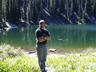
this is Steve at a mystery lake in the Payette National Forest

Wendy on the summit of the Payette Crest
Hi all,

Sad, but true, the summer is slipping away -- at least for the parents of kids who start school next week.

It's going to be hot as blazes this weekend -- temperatures are forecast in the mid-90's and higher on Sunday -- so I'm recommending that you dash to the mountains for a high-elevation hike in the cool air near Stanley or McCall.

Start early in the day and get to the trailhead when it's still cool in the morning, so you can enjoy a full day in the high country before you need to head back home. Be sure to bring a day pack with water, snacks, a lunch and a rain coat. Bring bug juice as well as sun screen. Wear a hat for sun protection.

If you go to the Stanley area, you can partake in the Sawtooth Salmon Festival on Saturday. "Fall in love with the miracle of wild salmon," the organizers say. Educational tours start at 11 a.m., you can go look at wild salmon spawning in the Salmon River (must-do activity), enjoy live music in the afternoon and evening, and chow down on a salmon feast in the evening.

Here are some suggestions for high-elevation day hikes:
  • Climb Observation Peak (elev. 9,151 feet) in the Sawtooths. This is the only mountain in the Sawtooths that has a trail to the top, according to summitpost.org. The hike from the Grand Jean Trailhead is 12 miles round-trip. Here are more details.
  • Hike to Red Mountain Lakes, near Lowman. This area is closer than Stanley. Drive to Lowman and go north on the Clear Creek Road (USFS Road #582) for about 12+ miles to a junction on the right with Forest Road #515. Take #515 to the trailhead. If you like to fish, try catching trout in the lakes.
  • Hike to Marten Lake, near Banner Summit between Lowman and Stanley. Watch for the trailhead just past Banner Summit. It's a pretty easy hike to Marten Lake from Banner Summit. It's about 5 miles to the lake. It's an out-and-back day hike unless you want to plant a shuttle vehicle at the Trap Creek Trailhead by Idaho 21, and it's about 10 miles total, and you won't have to retrace your steps. Again, bring your fishing pole if you like to fish.
  • Hike to 4th of July Lake and Washington Lake in the White Clouds. This is a nice, short one for young kids, but more of a drive. Drive to the Sawtooth Valley either via Stanley or Ketchum, and watch for the 4th of July Road on the east side of the valley. The long dirt road takes you to a high perch where you start hiking to 4th of July Lake, the first lake. It's only a mile to this location. Keep going into the White Clouds and you'll come to Washington Lake, within view of Castle Peak.
  • Hike to Snowslide Lake in the Payette National Forest near McCall. This is one of the more accessible lakes in the McCall area. The lake is only 1.5 miles from Lick Creek Road, northeast of McCall. Once at the lake, you could climb to Snowslide Peak (elev. 8,522) or just hike to the saddle to look into the Maki Lake basin.
  • Hike to Boulder Lake near Lake Fork, south of McCall. This is a pretty easy one, too ... 2.6 miles from the trailhead. You take Idaho 55 to Elo Road, go east on Elo to Forest Road #403, and go east to the trailhead at Boulder Meadows Reservoir. It's an out-and-back hike, with great views of the mountains in the Payette Crest.
  • Hike the Deer Point Trail to the top of Bogus Basin. If you don't have time to get out of town, here's a good one that I've blogged about before. It's a 5-mile loop that circumnavigates Bogus Basin.
  • Take the chairlift to the top of Bald Mountain in Sun Valley or Brundage Mountain in McCall. These are great options if people would prefer to get a "free" ride to the top. Both resorts charge a fee to ride the chairlift. At Sun Valley, it's $25 for one ride, and $30 for a full day. At Brundage, it's $10 for one ride, and $30 for a full day. Both mountains have great trail systems to explore if you'd like to walk down.
Pick up a Boise National Forest map, Payette National Forest map (McCall District), or Sawtooth National Recreation Area map for guidance on these trips. The easiest way to get these maps is from the Boise National Forest headquarters on Vinnell Way near Overland and Maple Grove.

Summitpost.com also is a great resource for climbing Idaho's mountains.

Have fun!
-SS

Steve shares his weekly outdoor tips with Ken and Tim on 94.9 FM The River each Friday morning at approximately 7:10 a.m. If you miss the program, you can hear the segments on River Interactive.com. Detailed descriptions and color maps of Steve's hikes, bike rides and paddling trips are available for 99 cents each atwww.stevestuebner.com, plus the full ebooks and hard-copy guidebooks.