 |
| Charcoal Gulch, Boise National Forest (courtesy Visit Idaho) |
Hi all,
When I see beautiful bluebird days like we've been having lately, I start yearning to visit Silver City in the Owyhees, upper Dry Creek in the Boise Foothills, Charcoal Gulch in Idaho City, and some of my favorite trails around McCall.
For my outdoor tip this week, I'll recommend five fall hikes below. All of these hikes are in my two hiking guides, Boise Trail Guide: 95 Hiking and Running Routes Close to Home or Owyhee Canyonlands - An Outdoor Adventure Guide.
The weather looks absolutely stellar for the next 7-10 days in the Boise area and Central Idaho! Cool nights -- freezing cold in the high-mountain elevations -- warm afternoons in the 70s and low 80s, and comfortable evenings while it's still light. Nothing better!
Before you go, for fall hiking, remember to pack a few more things such as a good rain/wind coat, a few extra upper layers, a good hat, skull cap? water, snacks and camera (your phone) and hiking poles.
 |
| The Mountain Coaster! (Courtesy Bogus Basin) |
1. Bogus Basin Mountain Recreation Area - It's the last weekend at Bogus where they'll be operating lifts, food and beverage. You can hike Deer Point to Elk Meadows and do a 5-mile around the hike or do the full 10-mile Around the Mountain hike, or something less or more.
2. Charcoal Gulch, Idaho City - Take a drive to Idaho City and go for a nice colorful hike on the Charcoal Gulch Trail, just on the outskirts of town. Find the trail by the Idaho City Airport (ever been there?) on the south side of town. There's a little trailhead on the north side of the airport. Take the Buena Vista Trail along the edge of the mountain, and then you'll see the junction for Charcoal Gulch. There are aspens and pines along the way, plus a small creek.
 |
| Silver City |
3. Silver City Sawpit Mountain Loop - It's an 8-5-mile loop that circumnavigates a timbered mountain with a bald pointy cap that looms over Silver City in the high-elevation community in the Owyhees. It's rated moderate to strenuous. The fall colors in Silver City should be starting to happen anytime! I wrote about this hike last fall for Idaho Press Outdoors. Please see my story for directions and details.
4. Freddy's Stack Rock Trail - Stack Rock is a signature granite pyramid-shaped rock on a timbered ridge to the west of Bogus Basin Mountain Resort. It's a 9.5-mile hike or bike ride from the trailhead to do the loop around Freddy's Stack Rock Trail. I would rate the hike/ride as moderate to strenuous because of a number of continuous uphills along the way, the distance and 2,600-vertical-foot gain/loss. You're walking/riding in the pines throughout the route, except when you get to Stack Rock, so that makes it scenic and intimate. Take a lunch to enjoy on Stack Rock.
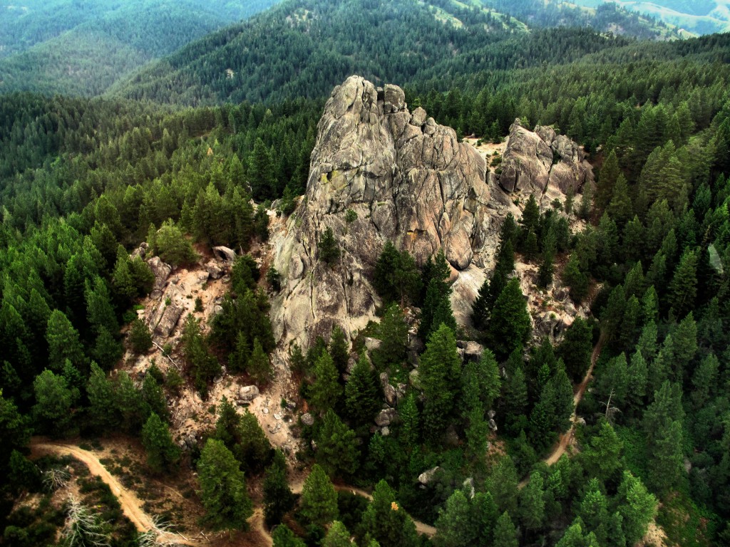 |
| Photo courtesy of Tom Lopez |
Backstory: Approximately 1,300 acres of the Stack Rock area came into public ownership courtesy of a $1 million donation by Boise resident Fred Alleman and additional funds from the Boise Foothills Levy Committee. The land was purchased from the Terteling family in December 2009 for $1.32 million to make it available for public use.
Directions: Park in the Forest Service parking lot and take the new trail over to Stock Rock/Sweet Connie junction to get started. Watch for the big parking lot on the right about Mile 12.
 |
| You'll see a number of nifty bridges on the Dry Creek Trail ... keeping your feet dry. |
5. Dry Creek out and back, Boise Foothills - Dry Creek is always a pretty hike, but especially right now, it should be great. The trailhead is off of Bogus Basin Road, several miles up from Boise, on the right side, as the road begins a series of hairpin switchbacks. You'll see other cars at the trailhead. It's a big day to hike to the top of the Boise Ridge via Dry Creek (7.5 miles, 2000+ vertical feet), so just take your time and go as far as you want.
Have fun!
- SS


