Thursday, December 18, 2014

Just in case you're stumped ... 10 Christmas gift ideas for outdoorsy men and women

Hi all,

The Christmas season is upon us, and perhaps you're struggling just a little in figuring out what kind of gift to get your outdoorsy lover, family members or friends?

It's amazing how many options exist these days ... new types of backpack stoves, super lightweight hammocks, solar chargers for mobile electronics, GPS units, mapping software, guided outdoor trips, high-tech comfy under garments and so much more! Just remember, when you're shopping for these items, look for opportunities to buy gifts from our locally owned outdoor retailers when possible.

My recommendations: 

1. The LifeStraw personal water filter is a valuable gift for a very affordable price, about $20. This nifty little unit works great as an emergency water filter that folks can carry in their backpack or Camelback. You drink directly from the stream through the LifeStraw to filter your water. The filter is supposed to remove 99.99% of bacteria, 99.9% of protozoa down to .2 microns in size.

A more robust water filter is still needed for filling water bottles and such, but the LifeStraw would be handy to have in a pinch when you forgot to bring your regular water filter. Or, if you're on an ultra lightweight adventure and don't want to pack a heavier filter. See this review for limitations of the Lifestraw.


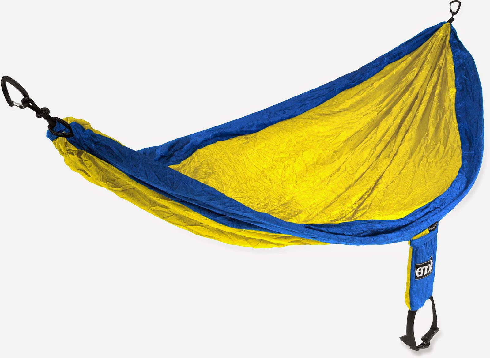
2. The ENO SingleNest Hammock is light and folds up into a compact size, about the size of a softball. For about $60, you can snag one of these for your sweetheart. It has a capacity of up to 400 pounds, so perhaps it could be shared by two (if your combined weight is less than that) on a lazy afternoon in the forest, swaying in the breeze. It comes in 7 different colors. It comes with a built-in stuff sack.


3. How about a new headlamp for your honey? I'm probably not the only one who always seems to come up empty when it's time to go camping. Where's my headlamp? I might have loaned it to one of my kids, maybe it got stuffed in the kitchen box or it's broken and dead. You never can have too many headlamps, I'd say. I bought the Black Diamond Storm headlamp last year for $60, and now I see the price has dropped to $45. It takes four AAA batteries, so it has a really bright light that illuminates to a distance of 230 feet. It has special red lights for improved night vision. Very versatile headlamp for all conditions. It comes in gray and orange.

4. Winter gloves are another item that seem to disappear or the left-hand glove goes missing or the right-hand glove disappears ... you need to have several pairs so you're ready to go cross-country skiing, biking, hiking, snowshoeing, whatever. The North Face Canyonwall Etip Glove for women looks perfect for active outdoor activities. They cost $39.95 at backcountry.com. Check out your local outdoor retailers such as Idaho Mountain Touring, REI Boise and Sierra Trading Post for lightweight gloves. If you want to find the most inexpensive pair, try your local hardware store or Thriftway in Boise. They sell nice lightweight leather gloves for $10, and they have cheap wool gloves, too.

5. Long underwear garments are another nice gift idea for him or her. You could add lightweight tights for men and women in this category as well. I purchased a pair of Patagonia women's tights for Wendy several years ago, and they've held up really well. She looks great in them. Cost: about $69. They're good for hiking, snow-shoeing, biking, xc skiing and lounging around the cabin.

There are many options available for long underwear. It's hard to beat REI brand polyester/spandex long undies for the price ($39-$49), but you can go whole hog and buy smart wool for deluxe warmth and comfort for $95. D&B Supply has a lot of great options for long undies, too, including the old-school full body undies.

6. Solar chargers for mobile electronics. I wouldn't be the first one in line for one of these units personally because I prefer to leave my iphone in the truck when I head off into the backcountry where there is no cell service. But a lot of people like to use their phones as cameras or for other features, so a solar charger is a must to keep your devices charged and ready to go. Amazon's best sellers range in price from $20-$80.

7. Stand up Paddleboards (SUPs) are the fastest-growing outdoor activity in America, so if you're thinking about splurging on a major gift for your honey, this would be a good bet. Here's a review of the many models available. Your best bet to shop for SUPs is go see a big variety at Idaho River Sports in Boise and learn about the pros and cons of inflatable SUPs vs. non-inflatable models, what length of board would be best for a person's height and weight, what style of board would be best for flatwater or whitewater, surfing, etc. Plus, you could sign up your honey for SUP yoga classes.

8. How about a handy camping knife for your lover? My personal preference is a ingle-blade fold-up knife for light and easy handling. There are many models to choose from. Buck knives are classic, dependable and long-lasting. Swiss Army knives are nice as well with their many blades, scissors, cork screw, toothpick, mini-saw and more. Knives are kind of like headlamps for me ... they tend to disappear. So it's nice to have several around the house or in the backpack or Camelback so you have one when you need one. Just like Grandpa, who always has a little single-blade knife in his pocket at the ready at anytime.

9. Winter cycling is very doable around the Boise area, and there are a number of accessories that are absolutely essential for this activity. No. 1 is to get a lightweight skull cap. There are many different types available for him and her. Some women's skull caps have a handy hole for the pony tail. You also need a nice pair of lightweight gloves. A form-fitting, wind-proof and waterproof shell is important, as are the under layers inside. Long underwear and tights are crucial for the lower body. And then some overboots for your riding shoes completes the winter cycling wardrobe. Check with your favorite local bike shop for these accessories, such as George's, World Cycle, Idaho Mountain Touring, Bob's Bicycles, Ken's Bicycle Warehouse, Meridian Cycle, McU Sports and Eastside Cycles.

10. Last but not least, how about buying an outdoor trip for your sweetie? Try to find a yurt or cabin rental at one of many Idaho State Parks or in the Idaho City Park n' Ski System. Look to rent a yurt at Sun Valley Trekking to access backcountry huts in the Smoky Mountains and the Sawtooth Mountains. Galena Lodge also has yurts for rent adjacent to their extensive cross-country ski trails. You also might want to consider a guided fishing trip, river trip, summer pack trip and more from Idaho outftitters. Check the Idaho Outfitters and Guides Association for more information.

Oh, and don't forgot, Steve's guidebooks make for great stocking stuffers! You can contact me at sstuebner@cableone.net to make arrangements for me to sign them.
---------------------------------
One more thing! My friend Jimmy Halliburton of the Boise Bicycle Project needs more bikes for their Christmas Kids Bike Giveaway on Saturday. They are short on bikes with 20-inch wheels and BMX boys bikes. Please share this news with your friends on Facebook (see a post you can share on my page) and help BBP cross the finish line for the kids in need!

If you'd like to sponsor a child for the Christmas Kids Bike Giveaway, see this link for more details. Many thanks!

Have a great holiday!
- SS

Thursday, December 4, 2014

Head for high country for best snow or try Eagle Greenbelt loop; plus, book-signing

Mark Lisk and I are having a book-signing event
at Lisk Gallery on Thursday, Dec. 11. See more
details below. 
Tom Hadzor of Wide Eye Productions also
will participate in our book-signing event.
If you like fishing, you'll love this movie. 
Hi all,

It's December, so it's time to crank up the outdoor tips for the winter season.

Did someone say, Winter? Yes, it's winter in parts of Idaho, but down here in the Boise Valley, it's been a pretty yucky combination of rain, inversion and gray days. Anyone tired of that yet?

If you'd like to find some good snow to play in this weekend, I'd recommend going for a ski or snowshoe tour at Mores Creek Summit near Idaho City. According to the Mores Creek snowtel site, there are 22 inches of snow at the parking lot, and more at higher elevations on Pilot Peak or Sunset Mountain. Temperatures were in the mid-30s today.

The Idaho City Park n' Ski Areas have about 18 inches of snow. The IDPR groomer is beginning to groom the trails for xc skiing, according to Leo Hennessy with Idaho Parks and Recreation. It'll be early-season conditions, but at least you can get out and play in the snow.

Better yet, if you don't mind driving over to the Sun Valley area, Galena Lodge has great conditions for xc skiing and snowshoeing with 50 kilometers of ski trails open right now, and 25 K's of snowshoe trails. Basically, the whole trail system is open.

"We have been so lucky to get over 2 feet of snow in the last week or so," says Erin Zell of Galena Lodge. "The conditions are fantastic. Some trails are still a little soft since they have just been groomed for the first time this week, but it is skiing like the middle of January right now!!"

The downhill skiing at Grand Targhee has been pretty solid, I hear from some friends of mine who skied there four days this week. There is a 38-inch base with 4 of 5 lifts operating. They have some great early-season lodging deals -- lodging and lift ticket for $65 per person.  
Eagle Greenbelt Loop - Try it, you'll like it. 
If you'd like to do an outing close to home this weekend, consider hiking, biking or running a loop on the Eagle Greenbelt, west of Glenwood. Now that the blockade has been removed on the south side of the Boise River, it's possible to do a complete loop on both sides of the river on the Eagle Greenbelt. You can start and finish by Bardenay near Eagle Road or by the Greenbelt parking area on Glenwood near Hawks Stadium. The full loop is about 10 miles. Mountain bikes would be best for biking because portions of the Eagle Greenbelt pathway have a dirt or gravel surface. Bikes will need to follow the bypass route around the Riverside walking pathway on the north side of the river.

Next week, on Thursday, Dec. 11, I'm teaming up with Mark Lisk of Lisk StudioTom Hadzor of Wide Eye Productions, and Three Rivers Ranch to host a book- and movie-signing party at Lisk Studio in Boise. The location is 518 Americana. Party starts at 5:30 p.m. and runs to 8 p.m.

Mark and I just reprinted our Owyhee Canyonlands guidebook after selling out our first print run of 2,000 books in one year. Last Christmas, the Owyhee Canyonlands books were flying off the shelf, and we hope our loyal readers will steer their friends and families to the book-signing event so they can buy the popular book for Christmas gifts.

To sweeten the deal, we're going to offer our Owyhee Canyonlands books at a discounted price of $15. That's about 25% off the retail price of $19.95. I will have all of my other guidebooks at the event, and I'll offer them at a discounted price as well.  

Hadzor will be selling Wide Eye's brand new hour-long fishing movie, The Rocky Mountain Fly Highway. Three Rivers Ranch opened a fly fishing shop in Eagle recently, and they'll be at our event with some fishing-related gifts. 

I watched the movie premier of The Rocky Mountain Fly Highway on KTVB-TV Channel 7 last night, and it was absolutely spellbinding with spectacular fly fishing footage of all of your favorite fishing rivers, from the Yellowstone to the Henrys Fork, South Fork Snake, Silver Creek, South Fork Boise, Owyhee River and more. It would be a great Christmas gift. The movie retails for $19.95, and for this event, Wide Eye will sell it for $14.99.

We'll serve free appetizers and beer and wine at the event. Come party with us and pick up some great gifts for your friends and family. Hope to see you there!

-SS

Thursday, October 9, 2014

Big game rifle seasons open in SW Idaho on Friday; a few tips on where to avoid hunters

Deer season opens Friday in many parts of Idaho. 
Hi all,

Head's up to hikers, trail-runners, mountain bikers and campers ... General deer season opens Friday, Oct. 10 in many parts of Idaho, and will remain open through the end of the month. Then, elk season will be following Nov. 1-9, and there are a multiplicity of hunting seasons that will be running through the fall, including upland bird hunting, duck hunting next to the rivers, and more.

If you're planning to go for an outing in the woods, be sure to wear bright colors -- hunter orange is pretty darn bright and effective! -- and put a hunter orange vest on your dog.

If you'd like to check out the hunting regulations to know the exact dates for the various hunting seasons, check out the Idaho Department of Fish and Game's web site for more information.

In the meantime, here are a few suggestions on where you might avoid hunters:
  • Ridge to Rivers trails in the Boise Foothills. The lower foothills trails would be best. There will be road hunters on the Boise Ridge Road, Rocky Canyon Road, Bogus Basin area, and in the Boise River Wildlife Management  Area, north of Harris Ranch. BTW, sheep were seen on the upper Three Bears trail yesterday; they are moving west for the next couple of weeks in the mid-foothills. 
  • October is a great month for visiting the Idaho Bird Observatory on top of Lucky Peak. I noticed that the public is invited to help the bird observatory crew work with owls on the 10th and 11th of October this weekend. See this web site for more information. Here's a video about the operation up there. Great chance to see birds of prey as they move from the Boise Foothills to points south. 
  • Trails in the Owyhee Front would be a good place to go without seeing very many hunters. Check out my book, The Owyhee Canyonlands - An Adventure Guide for specific ideas. I would recommend Succor Creek State Park, Leslie Gulch, Sage Creek, Browns Creek, Toy Pass and Between the Creeks as great places to explore this time of year.
  • Trails in the Hailey, Ketchum Sun Valley area such as Greenhorn Gulch, Hyndman Creek, Adams Gulch, and Galena Lodge area. 
  • Trails close to McCall such as Ponderosa State Park or Jug Mountain Ranch.    
  • Tamarack Resort Trails close to the resort. There are a bunch of short singletracks that are fun for hiking and biking like Pelican, Kestrel and Wild Turkey.  
  •  Anywhere you go in the Boise, Sawtooth or Payette national forest, you are likely to see hunters, so be aware of that. 
As I have done for a number of years, I am going to take a break with my outdoor tips during the fall hunting season, and start them up again after the snow flies. Have fun out there!
- SS    

Thursday, October 2, 2014

Idaho Hot Springs mountain biking route proves to be a big hit with cyclists

Looking out the double doors in the hot springs behind
the Mountain Village Hotel in Stanley.

Looking over at Redfish Lake from a White Clouds singletrack trail. Wowsa!  
Riding through an old Idaho burn in Central Idaho.
Camping by Washington Lake in the White Clouds. 
Hi all,

We're in the heart of the fall season, and the weather is pretty much perfect for biking. It's a good time to tackle some challenging high-elevation rides because of that wonderful cool, crisp mountain air.

I wanted to recommend the Idaho Hot Springs Route, as something to consider this fall -- not necessarily the whole thing (the route is over 500 miles) -- but maybe there are chunks of it that you'd like to ride before the snow comes, whenever that may occur.

The Hot Springs Route is a brand new mountain biking route, the brainchild of Casey Greene, an avid rider and a cartographer for Adventure Cycling in Missoula, Mont. Casey came up with the idea after doing a 10-day bike tour across North Idaho and Montana when he and some friends biked to a different fire lookout tower every night. "At the end of the tour, I thought this whole concept of having a destination where you end up each night was kind of cool ... basically, destination mountain biking," Casey said.

The light bulb for the hot springs route went off when he was soaking at a hot springs in Pole Bridge, Mont. He was thinking that Idaho had the highest concentration of hot springs in North America, so why not try to connect the dots? He started evaluating the situation from looking at maps, plotting the hot springs, looking at connecting routes, and came up with a tentative route. Then he ground-proofed them to see if it would work. Last summer, he rode the whole route that's connected by dirt roads, all 517 miles of it, and he also logged a number of singletrack routes that add spice to the whole experience.

Adventure Cycling published a set of two maps -- the main route and the singletrack routes (227 miles), and rolled them out in February. Turns out Casey had a pretty hot idea! The maps are selling like hot cakes and they've already done three printings in the last eight months. The first version came out in February 2014.

Lots of people are trying the route, and they're really enjoying it, Casey says. Dylan Gradhandt of Boise rode the entire dirt road route with his brother-in-law in mid-June. "It was a blast, I'd do it again," Gradhandt says. "In bicycle touring terms, I'd give it a huge "approved for all audiences" rating. It's actually super doable for the average cyclist, in my opinion." 

It took them 11 days of pedaling to cover the whole 517-mile route. They resupplied every 2-3 days. They included one rest day. They did the whole route without vehicle support and traveled very light with special bike packs. 

You can see the pack set up on the bike and a very lightweight tent ...
photo courtesy Dylan Gradhandt
The timing of the hot springs route was great because the whole sport of "bike-packing" is becoming quite popular, and the hot springs route is tailor-made for either bike-packing or riding with vehicle support, Casey says. "Bike-packing is like the new hot thing right now." 

Plus, cyclists from all over the nation are realizing that there's a lot more to Idaho than just potatoes. "The hot springs are like the big enticement, but once people come to Idaho, they are blown away by the scenery, the people, and the rugged mountains," he says.

The main hot springs route follows dirt roads.
It's a big loop from Boise to Ketchum to McCall
and back. 
The main hot springs route provides access to 41 hot springs along the way. Because it follows dirt roads, Greene says you could do the route with light-weight bike-packing gear, more traditional panniers, or Bob trailers. You also could do it with vehicle support, and take turns driving the support vehicle.

The optional singletrack routes feature a number of popular mountain singletracks such as the Bear Pete Trail near Burgdorf Hot Springs, Eagle's Nest Trail near Cascade (both featured in my Mountain Biking in McCall book) and some of the sweet singletracks in the White Clouds and the nifty Willow Creek trail along the South Fork of the Boise River near Featherville. The singletrack optional route provides access to another 10 hot springs.

Optional singletrack trails on the Hot Springs route. 
You'll need to order the two-map set to get all of the details. They cost only $29.50. You can order the maps on the Adventure Cycling web site.        

If you decide to stay overnight on the singletrack trails, Casey recommends going light and using the new bike-packing set up. Check out the images here. You will be doing some hike-a-bike on the singletrack trails, and if you have panniers or a Bob trailer, your equipment will get hung up on trees, brush, rocks or roots.

This is what it's all about. Daryl Gradhandt photo.
Casey said they've heard from some flatlanders who have tried the route and didn't expect to encounter the challenges you'd find on rugged mountain singletracks. But many Idaho riders know what to expect cuz they've been riding these trails for years.

One of the silver linings of the hot springs bike route is that small communities like Atlanta, Featherville, Stanley, Cascade and McCall are noticing how many cyclists are discovering Idaho via the hot springs route. The small cafes and restaurants appreciate the business! "I can't believe how many riders came through McCall this summer specifically because they were doing the hot springs tour," says Gregg Lawley, owner of a bike shop in McCall next to Paul's Market.

Lawley decided to venture out on his own bike-packing adventure in the White Clouds last week. "It was one of the coolest trips I've ever done," he says.

Just casual checking indicates that a few Idaho people have tackled the entire hot springs route already, including Gradhandt and his brother in law, and more cyclists are making plans to ride it next year. I'd recommend buying the maps, downloading the GPS tracks and dreaming big about a unforgettable bike ride next year with your friends.

Thanks to Casey Greene for showing us the way!
- SS

Thursday, September 25, 2014

Give back to the earth on National Public Lands Day; volunteer to improve the land

Hi all,

Do you ever think about how wonderful it is to live in a state like Idaho that's richly endowed with public lands? I do. I've spent a lifetime trying to explore Idaho's national forests, state parks, state lands, BLM lands -- hiking, biking, camping, boating, skiing, backpacking, fishing, hunting, etc. etc. All of those adventures are what we live for. They give us a rich quality of life. Friendships. Hardship. Tons of fun! Thus, we should take a moment to cherish our public lands this weekend in observance of National Public Lands Day on Saturday, Sept. 27.

CIMG2376
Trail volunteers assembled for a similar project in the Big
Jacks Creek Wilderness last year. 
One way to do that is head out for an adventure. Another is to give back. The weather looks crummy, so you might consider giving back. There are a number of volunteer opportunities going on in SW Idaho as part of National Public Lands Day. 

My #1 pick is to help out with finishing a BLM trail into Shoofly Creek and Between the Creeks in the Little Jacks Wilderness, near Grand View. You can either camp out Friday night or meet up Saturday morning at 9 a.m. at the Poison Creek picnic area on Mud Flat Road, south of Grand View. The Idaho Trails Association is a project co-sponsor along with Boise REI and the Idaho Conservation League.

This year, the NPLD theme is to recognize and celebrate the 50th anniversaries of the Wilderness Act and Civil Rights Act. There will be speakers there to talk about both. 

Getting there: Take I-84 east of Boise to Simco Road. Turn right and drive to Grand View. At the T-junction in Grand View, turn left and drive to the signed right-hand turnoff for Mud Flat Road, the Owyhee Uplands Backcountry Byway. Follow Mud Flat on pavement and dirt until you seen the Poison Creek picnic area on the right. It's good gravel road for any 2WD to reach this point. 

Bring your rain gear. The BLM is serving breakfast and lunch. 

For more information, contact Dave Draheim, at the Boise BLM 208-384-3358 or ddraheim@blm.gov. 


  • Volunteer to help enhance the Deer Flat National Wildlife Refuge for wildlife and visitors. Meet at the Deer Flat Visitor Center at 9 a.m. Saturday. For more information contact Kacey Kai at 467-9278.
  • The BLM is leading a project to plant sagebrush seedlings on Kuna Butte near Kuna. There also will be birds of prey on display at lunchtime, a swainson's hawk, great-horned owl and gold eagle. For more information, contact Barb Forderhase of the BLM, 384-3485 or bforderhase@blm.gov.
----------------------------------
Looking for a used Stand up Paddle Board? I saw that Idaho River Sports is having a September blowout sale ... they're calling it, SUPtember. IRS actually has a whole bunch of sweet deals going on through the end of this month, including half-price SUP rentals and great discounts on SUPs, canoes and other gear. Check it out! 


Have fun!
-- SS 

Thursday, September 11, 2014

Fall colors are starting to turn! Head to Idaho City for three day hikes in the colorful forest

Gotta love the old-fashioned charm in Idaho City! 
Long views of the Sawtooths from Pilot Peak 
Hi all,

The days are getting shorter, and the nights are getting cooler, causing the fall colors to unleash their beauty in the Boise National Forest. This week, I'm recommending three hikes in the Idaho City area in the Boise NF where you are likely to see some colorful changes in the shrubs, ground vegetation and maybe some aspens and alders.

The weather should be fabulous for a mountain outing this weekend, with temperatures in the 80s in Boise, and 70s in the mountains. It'll be chilly in the mornings.

All three of these hikes are featured in my book, Boise Trail Guide: 75 Hiking and Running Routes Close to Home. Remember that bow season is open so you may see some people covered in camo pursuing deer or elk in the woods. You also may see bird hunters going after forest grouse. You could combine your hiking adventure with a stop at The Springs in Idaho City to enjoy a nice soak in the hot springs. Note to self: Reservations are required.
My guide suggests a full loop including the Centerville Road
but that's mainly for runners; don't recommend it for hiking 
Hike #1 - Charcoal Gulch in Idaho City - Distance: 4 miles out and back. Approximately 2 hours travel time. Vertical gain: 1,100 feet. Rated moderate. You could combine this hike with a little tour of the rustic old mining town, visit the museum and maybe get a bite to eat.

Getting there: From Boise, take Idaho 21 east to Idaho City. Turn left on main street and follow that several blocks to a junction with Bear Run Road on the right and Centerville Road on the left. Turn left on the Centerville Road and follow that for one-quarter mile to Buena Vista Road on the left. Turn left and follow Buena Vista, past the Idaho City Airport, to the parking area and trailhead for Charcoal Gulch and Airport loop trail. Park.

The hike: Head west out of the parking lot and take the ATV-type trail along the base of the mountain for a half mile to the junction with Charcoal Gulch Trail. Turn right and climb Charcoal Gulch 1.5 miles to the top. Take a break on top and retrace your steps to the trailhead.
The route to Pilot Peak. 
The Pilot Peak Lookout seems to have a different
function these days than a fire lookout.
Photo courtesy Ron Kemnow
Hike #2 - Mores Creek Summit to Pilot Peak Lookout - Distance: 7.9 miles up and back. Hiking time: 3.5 hours or more. Vertical gain: 2,043 feet. Rated strenuous.

Getting there: From Boise, take Idaho 21 east to Idaho City. Continue east on ID 21 to Mores Creek Summit. There is a large parking area and rest room on the right side of the road. 

The hike: Cross the road to hike up to Pilot Peak. Follow the two-track gravel road as it climbs to a saddle junction 3.2 miles from the trailhead. Take a hard right to climb a little over a half mile to the summit. Retrace your tracks to the trailhead. Bring a lunch and plenty of water. Enjoy the big views of the Boise National Forest from the summit. You can see the backside of the Sawtooths, Steel Mountain and much more. 
Follow USFS Road #316 to Sunset Mountain Lookout. 
Sunset Mountain Lookout is usually manned in the summer months.
Photo courtesy Ron Kemnow
Hike #3 - Mores Creek Summit to Sunset Mountain Lookout - Distance: 9.4 miles up and back. Hiking time: 4-5 hours. Vertical gain: 1,800 feet. Rated strenuous. 

Getting there: From Boise, take Idaho 21 east to Idaho City. Continue east on ID 21 to Mores Creek Summit. There is a large parking area and rest room on the right side of the road.  

The hike: From the parking lot, hike up Forest Road #316 to the top of Sunset Mountain. The 4WD dirt road is not as steep as the hike to Pilot Peak because it has some sections where it flattens out and the gradient is less severe. But it is farther to Sunset Lookout. The lookout building itself is still manned during the summer months for fire reconnaissance. It's a beautiful perch from the summit -- you can enjoy a bird's eye view of the North Fork of the Boise River, the backside of the Sawtooths and Steel Mountain. Be sure to pack a lunch and bring plenty of water. 

There you have it! Enjoy the beautiful fall weather!
- SS 

Thursday, September 4, 2014

Try these two hikes/rides close to home: Polecat Gulch and Watchman Loop

Wendy and I ran into Dave Kordiyak on the Polecat Trail,
overlooking the Terteling Ranch. 

Polecat Gulch near Quick Draw junction
There's almost always water for dogs in Five Mile Creek.
These are my boys Quinn and Drew 
New Polecat Gulch Trailhead. Looks pretty snappy! 
Hi all,

I rode the Polecat Gulch Loop on Monday, and I was pleased to see that the City of Boise had completed the new trailhead for Polecast via North Collister off of Hill Road! This will make it much easier to access Polecat Gulch for many people in Northwest Boise. It's also a good reason to talk about the benefits of hiking, running or biking in Polecat Gulch in my outdoor tip of the week.

This week, I'm also going to suggest doing a long hike or ride on the Watchman Loop in NE Boise. The cool weather has been fabulous for foothills recreation this week, and it appears that it will continue this weekend, at least in the mornings. The highs this weekend in Boise are projected to be in the mid-80s in the afternoons.

Both of these hikes/rides are a little off the beaten path because they're not in the Central Foothills where many people go day after day. I'm recommending these hikes/rides close to Boise because the kids are back in school, so it's harder to get out of town for many people. If you can escape, it should be fabulous weather for a high country adventure in McCall, Stanley or Sun Valley.

Let's start with Polecat Gulch. This area was a key new 834-acre open space reserve purchased by the City of Boise in 2002 with funds from the 2001 Foothills Levy. It opened up a great system of trails in an area that had been previously unaccessible because its private land status. The trails in Polecat are more moderate than many in the foothills, so that's another draw. This area also is home to albino mule deer. I've seen them myself!
Polecat Gulch map (click to enlarge)
How to get there: Take Hill Road to N. Collister in NW Boise. Turn north on N. Collister and proceed to the Polecat Trailhead at the end of the road. There is a restroom in the parking lot.

The Polecat Gulch "finger" loop as I call it in my guidebooks, Boise Trail Guide and Mountain Biking in Boise, is approximately 6 miles long. It circumnavigates the whole gulch. I call it a finger loop because the trail snakes around little ridges that extend like a finger from the top of the gulch. It takes about an hour to do the loop on a bike, 1.25 hours for trail-runners, and several hours if you're hiking.

There are shorter loops you can do, too ... For instance, you could hike/ride up the bottom of Polecat Gulch from the N. Collister trailhead, and take QuickDraw to the top of Doe Ridge, and come back via the Polecat Loop trail. That would be about 2.5 miles.

Go visit Polecat from either the N. Collister side or the Cartwright Road trailhead ... you'll like it!


The Watchman Loop is one of the best hikes/rides in Boise IMHO. Starting from the bottom of Rocky Canyon Road, the loop is 10.2 miles long. It takes me a little less than 2 hours to ride it fast. It'd be a much longer trip if you're hiking -- about 4 hours. I rate the mountain bike ride advanced, and I rate the hike strenuous. The route features 1,900 feet of climbing. It's a fairly challenging route, but the views and the countryside you tour make it a four-star experience in my book.
Five Mile - Watchman Loop (click to enlarge)
Directions: Start at the bottom of Rocky Canyon Road at the end of the pavement. Proceed up the dirt road 2.5 miles to the Five Mile Creek Trail on the left. Climb Five Mile to a junction with the Orchard Gulch connector. Go straight and climb the steepest section of the trail for the next quarter-mile. The junction with Watchman comes up after you cross a creek at mile 4.2. The hard part is over!

Watchman Trail contours along Five Mile Creek canyon, offering big views of Rocky Canyon. Then it takes you over to another un-named canyon, and then you zoom downhill to Three Bears and follow Curlew Ridge all the way back to Shane's Summit in Military Reserve. Ignore the right-hand junction with Trail #6 before you hook up with Three Bears.

Bring plenty of water and food and enjoy the day!
--------------------------------
I saw two volunteer opportunities coming up that looked fun and important:
1. Volunteers are needed for Greenbelt surveys to be held later in September. Contact Jerry Pugh, jpugh@cityofboise.org or call 608-7617.
2. Volunteers are needed for bike counts on Boise city streets. The Treasure Valley Cycling Alliance is coordinating the effort. Go to their web site to sign up: www.biketreasurevalley.org

-SS

Thursday, August 28, 2014

Hike & camp by Crooked River or tackle the Silver City Skyline Tour for Labor Day

Fishing Crooked River
Leo Hennessy, Jerry Quick and Doug Lawrence near War Eagle Mountain.
Jim Young enjoys the views on the Silver City Skyline Tour 
Hi all,

I've got a couple of last-minute ideas for Labor Day weekend, places where you could go for a hike or a bike ride and camp nearby -- Crooked River near Idaho City or the Silver City Skylline Tour, starting and finishing in Silver City in the Owyhee Mountains.

The weather will be on the cool side in the mountains on Saturday, Sunday and Monday for Labor Day weekend, with temperatures in the 60s forecast in McCall, Stanley and Ketchum/Sun Valley, but to me, that's a bonus. Love the cool temps that come with fall weather! If you stay in town, it's supposed to fall into the high 70s, which sounds pretty fab for Boise, too!

The Crooked River Trail is featured in my Boise Trail Guide - 75 Hiking and Running Routes Close to Home. The easiest way to access the trail is via the Edna Creek Road off of Idaho State Highway 21, northeast of Idaho City and Mores Creek Summit. You'll see a highway sign for the Edna Creek Road and Atlanta, turning right off Idaho 21, about 60 miles east of Boise. There is a pull-out for the trailhead on the Edna Creek Road in the first half-mile from the highway. You can either hike or bike from here.

The trail is a moderate hike, but a little more challenging as a mountain biking trail because it is all singletrack, and that makes the riding a little trickier and technical. The trail runs downhill along Crooked River, but remember, you will have to climb back to the trailhead. About 4 miles down the trail, it becomes more sketchy with downfall, and you may want to turn around. The trail is supposed to extend all the way to the North Fork of the Boise River (10 miles one-way) but it needs much more clearing and maintenance to make that trip doable for Joe 6-Pack. 
Crooked River map. Click to enlarge. 
Bring a fishing pole if you like to fish. It's a beautiful creek with nice deep holes, and it's in a beautiful pine and fir forest setting. Be sure to bring a lunch with you to enjoy the scenery. 

Camping nearby: There are many unofficial camping areas on the Edna Creek Road in the first few miles after you turnoff of Idaho 21, and there's an official campground called Willow Creek about five miles up the road. There also are many self-support camping areas along the North Fork of the Boise River on the way to Deer Park. 
Silver City Skyline Tour map 
Now, if the notion of tackling the Silver City Skyline Tour in the Owyhees sounds appealing, I'll provide some basic directions for this 16.8-mile mountain bike ride, but I'd recommend buying my guidebook for the best details. I rated it strenuous/advanced in The Owyhee Canyonlands - An Outdoor Adventure Guide. It features 2,750 feet of vertical gain. I loved the ride because it provides a rooftop tour of the mountains surrounding Silver City, and it's nifty that you start and finish in downtown Silver City. Be sure to bring plenty of food and water. After the ride, there are lots of places to camp just outside of Silver City or along Jordan Creek, you make the call. 
Back in downtown Silver City after the ride. Wa-hoo!
Doug Lawrence on the left, and Paul Hilding. 
Directions: Drive to Silver City and park off to the side of Main Street near the old hotel. To get there, go south of Nampa on ID 45 to Murphy. Watch for signs for Silver City on ID 78 as you're heading for Murphy, and follow the paved and dirt road to the historic mining town. 


Mile 0 - Ride back toward New York Summit from Silver City. 
Mile 1.2 - Turn right on BLM Road F483. This is your main route for the first half of the ride.
Mile 2.4 - Bear right on Road F483 at Y junction and climb.
Mile 4.7 - Reach junction with service road to the top of War Eagle Mountain. It's a short, but steep sidetrip to check out the summit. Check out the old buldings and mine shafts at the Poorman Mine near this junction ... it's a short sidetrip.
Mile 5.9 - Back at War Eagle junction. Bear right on Road F483 and cruise on your middle ring to the ridges and mountains to the south.
Mile 6.7 - Bear right at Y junction next to livestock watering area. Bear right again shortly afterward and climb a steep hill with lots of mobile rocks.
Mile 7.9 - Come to sweet overlook to the left of the main road. Cruise over to the trees to enjoy views looking out toward Triangle and the big wide open country of the Owyhees.
Mile 8.4 - Pass through barbed-wire gate.
Mile 9.2 - Bear right.
Mile 9.4 - Ignore trail going downhill on the right. Stay on the ridge.
Mile 9.6 - Pass through barbed-wire gate.
Mile 11.1 - Bear right and pass through gate. Going downhill now on ATV track.
Mile 11.8 - Come to 4-way junction. Take a hard right and climb super-steep ATV trail to a saddle at 12.6. Parts of the climb are rideable; some parts not. Go left at the junction and climb a little more until trail flattens out.
Mile 14.0 - Come to 4-way junction. Turn right and descend into Long Gulch on a jeep trail. It's a fun descent back to Silver City. There are a number of creek crossings.
Mile 16.8 - Arrive in downtown Silver City. You made it!     
-----------------------------
Have you heard of the Idaho Smoke 'n Fire 400? A friend of mine, Scott Frey, told me about it at Tour de Fat, and it sounds totally amazing. It's a self-support mountain bike race starting on Wednesday, Sept. 10th in Boise, and god knows when riders will finish. They will be carrying their own overnight gear -- call it "bikepacking" -- as they ride an incredibly arduous course from Boise toward Anderson Ranch Dam to Ketchum to Stanley via dirt roads and trails to Bear Valley, Deadwood Reservoir, and then back toward Placerville before climbing over the Boise Ridge back to town. Wow! 

Sign up if this sounds appealing. Thirty-seven riders have signed up so far, including Scott. There is no entry fee and there are no prizes. Just bragging rights and survival.   
------------------------------
If you do stay in the Boise Valley this weekend, be aware that there are numerous Labor Day sales going on at your favorite outdoor stores -- preseason sales on skiing equipment, and closeout sales on boating, biking, hiking and camping equipment. Great time to buy!

Have fun!
- SS 

Thursday, August 21, 2014

Two must-do rides in the White Cloud Mountains that will blow you away

These guys are living large in the White Clouds! L-R, Mark Anderson,
Mack Lyons, Roberto Negron, Steve Schneider and Jim Young.
Woo hoo! Roberto Negron descends into
Chamberlain Basin on a steep series of switchbacks,
with Castle Peak in the background.  
Hi all,

I missed out on a big weekend with some of my mountain bike buddies in the White Cloud Mountains because I was just coming off a Middle Fork Salmon River trip, and couldn't fit it in. But I heard all about it -- "it was totally epic, man ..." -- I've seen the photos, and my friends pretty much were exhausted and exhilarated all at once after the experience.

I'm recapping their experience in my blog this week because the two rides they notched in the White Clouds are some of the best rides in Idaho and the Rocky Mountain West, in my opinion. The scenery is totally spectacular. Very unique. It's pretty rare to ride by high mountain lakes and high peaks like you do in the White Clouds. 
Hanging out on the saddle divide ... 

On Saturday, they rode a huge traverse in the White Clouds from 4th of July Creek Trailhead to the East Fork of the Salmon River. This ride is often referred to as the Castle Divide Trail. They also rode the Big Boulder - Frog Lake - Little Boulder Loop. Both of these rides will be doable until the snow flies in October. September would be a great time to plan to go there. These rides are pretty much advanced to expert cross-country rides because of the endurance and skill set required. 

"Oh man, it was incredible," said Doug Lawrence, a retired school teacher. Noting that the big loop took them 7.5 hours, Doug said, "it was a frickin' workout. But what an incredible downhill from the Castle Divide all the way down Little Boulder Creek. It was 9-10 miles of downhill, and there was cold beer in the rig, so that was perfect."

"I thought the Big Boulder-Little Boulder Loop was fun, but the big traverse was totally awesome," added Jim Young, a retired log home builder. "I'd say that's a bucket-list ride for sure. You've got to do that once in your lifetime."
Remember that the White Cloud Mountains are used by horseback riders,
backpackers, motorbikes, trail-runners, etc.  ... so keep a watch ahead on the
trail for other users and yield accordingly.   
Plus, folks who worry about how the proposed Boulder-White Clouds National Monument would affect these trails will be relieved to know that both of these loops are included in a MOU hammered out by IMBA and the Wood River Bike Coalition with monument advocates. Both loops would remain open under the monument proposal. 

Loop #1 - Big Boulder-Little Boulder Loop - About 20 miles. Riding time: 5.5 hours. Vertical gain: 2,800 feet. Access is off the East Fork of the Salmon River Road. Take the dirt road up Big Boulder Creek to the Livingston Mill area and the Big Boulder Creek Trailhead. Take the Big Boulder Creek Trail to the Frog Lake Trail and descend on Little Boulder Creek. The climb is reasonable on Big Boulder Creek Trail, and the downhill on Little Boulder Creek is rocky and technical in places. Leave a shuttle vehicle at the bottom of Little Boulder Creek. 

Loop #2 - White Clouds Grand Traverse - "Castle Divide" Ride - 25 miles. 5,000+ vertical gain; riding time 6-7.5 hours. Sturtevants in Ketchum runs a regular shuttle service. Call 726-4501 to book it. You can leave Sturtevants in Ketchum at 8 a.m. and be back by 6 p.m. They drop you off at 4th of July trailhead and pick you up on the East Fork. My friends hired a Stanley shuttle service (Sawtooth Transportation) to take them from the East Fork to the 4th of July trailhead, and they camped on the East Fork. 

The Castle Route route is totally amazing ... you start at the 4th of July Trailhead, ride over to Washington Lake, then climb over to Chamberlain Basin, ride a super-steep trail to the top of Castle Divide (on the shoulder of Castle Peak), and then descend on the Little Boulder Trail down to the East Fork. So there are three major climbs and then the long rocky downhill on the Little Boulder Creek Trail. 
All eyes on the map! 
"It's pretty cool to ride through the pine trees, aspens, red rocks and sagebrush until you come to the East Fork," said Mark Anderson, an engineer in Boise. "Because of all the climbing and the stops we made along the way, we only averaged a little better than 3 miles per hour. We were all pretty gassed by the end. One of our guys fell off his bike on Little Boulder, so he was hurting pretty bad by the time we finished."

The folks at IMBA put together this super-cool virtual tour of the Castle Divide Ride. Check it out.

In case you're interested in the monument proposal, and how mountain bikers would be affected, see this press release on the MOU from the IMBA web site
Paul Hilding strikes a pose 
Full disclosure: I personally am in favor of the monument proposal because it would allow nearly all of the key mountain bike trails to remain open in the White Clouds, while protecting the ecological values in the high alpine areas and world-class fish and wildlife habitat. The old wilderness proposal (CIEDRA) would have closed off a number of those routes to biking, but the wilderness bill appears to be dead in our do-nothing Congress. I work for several groups in support of the monument, so I am biased. I'm also a longtime IMBA member. 
Beer-me now! 
Hope you have a chance to experience these rides. You will love it! 
-SS