Thursday, April 27, 2017

Weather warming up this weekend and next week! Time to head for the Owyhees!

Jim Giuffre, foreground, Steve Schneider and Doug Lawrence just finishing the China Ditch Trail ... 
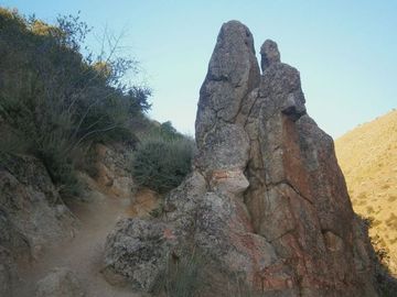
Sheep Creek Canyon cuts through old rhyolite lava rock 
Stopping to enjoy the grandeur of Reynolds Creek canyon. 

Hi all, 

The forecasts are predicting that we'll get a break from the rain this weekend, and next week the temperatures might hit 70 degrees F! OMG! Time to head out for a spring hike or bike ride in the Owyhees! Maybe take your camping gear and stay overnight? 

I just completed a 3rd printing of The Owyhee Canyonlands - An Outdoor Adventure Guide, so I've got plenty of books on hand if you haven't purchased your copy yet. The books are available on my web site, stevestuebner.com, Boise REI, Idaho Mountain Touring, Owyhee County Museum gift shop in Murphy, and Amazon

For this week's outdoor tip, I'll dish up two hikes and one mountain bike ride in the Owyhees. 

John Wheaton, Amy Haak, Wendy and me on
a winter ride on Bingo's Trail. 
First, the bike ride - the Wilson Creek - Northwest Passage Loop. Distance: 16.25 miles; travel time: 3.5-4 hours; vertical gain: 2,075 feet. Rated strenuous. Mountain bikers love this ride. It's almost all singletrack with a couple of short sections of two-track road. The Soda fire did a number on Reynolds Creek canyon, which some people feel has diminished the scenery. But I still think it's a great ride. 

See my blog post with photos, a map and blow-by-blow directions of the ride

Now, the hikes: 

1. Wilson Creek-Reynolds Creek Loop - Distance 7.4 miles; travel time: 3.5 hours; vertical gain: 750 feet; Rated moderate to stenuous ... mostly moderate. This is a shorter version of the Northwest Passage loop. Getting there: From downtown Boise, take I-184 west to Nampa. Take the Franklin Road exit (City Center) in Nampa, and turn left. Follow Franklin to the intersection with 11th Street. Turn right and take 11th into downtown Nampa. Follow signs for Idaho 45 south. Take ID 45 to Walters Ferry at the Snake River and turn right on ID 78, heading for Marsing. In a couple miles, turn left on Wilson Creek Road. Proceed up the paved road, past the cattle feedlot, until it turns to dirt and pull into a dirt parking area on the left, the trailhead for Trail #300. The hike starts here.

This is a great hike (good for trail-running, too) in the foothills of the Owyhee Mountains, about 45 minutes from Boise. The trail weaves through rock formations on the way over to Reynolds Creek, and then you hike the China Ditch trail along Reynolds Creek. The red rock canyon is spectacular. Bring your camera, plenty of water and a lunch. Even though the route is 7+ miles, the elevation gain is pretty minimal, so the hike may be suitable for kids 8 and over. My kids enjoyed the hike, especially throwing rocks into the creek.

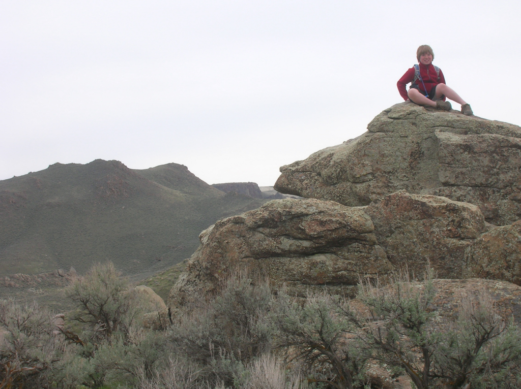
Quinn hangs out on a big rock 
Directions: To begin, pick up Trail #300 out of the parking lot. Ignore trails branching off to the left in the first mile. At mile .9, you’ll cross a road and continue on the singletrack trail. The trail climbs one last hill and then widens into a two-track and descends to a T-junction at a dirt road (mile 1.8). Go right for a short bit, and turn left on Trail #410, a sandy wash going downhill towards Reynolds Creek. At mile 2.3, go right on Trail #310 and proceed for a half mile to a junction with Trail #600, the China “Ditch” trail. Go right and walk upstream along Reynolds Creek canyon for a long mile. After walking next to vertical rock walls, the trail opens up on the right at the junction with Trail #510, #601 and #610. Go right on #510 and climb out of the canyon. At mile 4, bear right at a Y junction on #510 and stay on #510 to BLM dirt road #37154. Go right and follow the road to the junction with Trail #400. Go left on #400 at mile 5.28 and head back to the trailhead. At the top of the first hill, you can either stay on Trail #400 or branch off on #300. Both ways head over to the Wilson Creek Road and the trailhead.

Sheep Creek canyon is deep! 
2. Mary's Creek to Sheep Creek Canyon - Distance: 8.75 miles; travel time: 4-5 hours; Vertical gain: 1,389 feet; Rated moderate to strenuous. This is a neat hike that takes you over to the deep incised canyon of Sheep Creek, where it's possible to camp by the creek or certainly stop and have lunch there before you head back. Mary's Creek also lies inside a BLM wilderness area, so this is a hiking-only experience. 

Road access: Easy, any kind of 2WD vehicle will work to reach this trailhead. 

Getting there: From Boise, take I-84 east to Mountain Home. Take the first exit to downtown Mountain Home. Proceed through town and watch for Idaho 51 to Bruneau. Turn left on Idaho 51 and go to Bruneau. Pick up any last-minute snacks/beverages and head south on Idaho 51. Check your odometer when you leave Bruneau. It's about 40 miles from Bruneau to the signed turnoff for Roland Road on the left, just past the old bar and junk yard in Grasmere. Go left on Roland Road, and take that good-quality gravel road 5.2 miles to the signed Mary's Creek Wilderness Trailhead. The hike starts here.   

General remarks: Mary's Creek is one of the more easy-to-access trailheads in the Sheep Creek/Bruneau Wilderness area. It's a scenic basalt canyon that drains into the much-deeper and spectacular box canyon of Sheep Creek. It's possible to do either a day trip here, or take a backpack and camp overnight at the Mary's Creek/Sheep Creek confluence, do some exploring and enjoy some quiet peace of mind. The day hike features a cross-country walk along the edge of Mary's Creek canyon for 3+ miles to the edge of the canyon rim. Then, there's a nice little singletrack hiking trail, called the Tindall Trail, that drops down to the confluence area, where there are several areas large enough for a campsite. We returned to the Mary's Creek Trailhead via a rough and rocky two-track road, just to make the walking a little easier. The two-track is drivable with a high-clearance 4WD rig, outside the wilderness boundary, if you want to drive directly to the canyon rim. I'd recommend this hike for kids who are 8-10 years old and up.       

Directions: To start, hike through the sagebrush along the left side of Mary's Creek canyon. It will get considerably deeper as you approach Sheep Creek canyon. At mile 3.6, you'll arrive at the canyon rim, where you'll see a singletrack trail winding through the rocks down to the Mary's Creek/Sheep Creek confluence. It's .7 miles and 520 feet of descent from the rim to the confluence. Great spot for lunch or overnight camping. Retrace your steps to the canyon rim, and take the two-track road back to the trailhead. Final mileage is 8.75 miles.

Have fun! Hoping for sunshine all weekend! 
- SS 

Thursday, April 20, 2017

Five kid-friendly spring hikes in the Boise Foothills -- easy shorties & long ones too

A dad and young kids out on the Surprise Valley-Oregon Trail Loop
Highlands Trail hugs the foothills, climbing up to the Corrals Trail on a moderate grade. 
Hi all,

The weather looks promising in the Treasure Valley area on Friday and Saturday, but now it's supposed to rain on Sunday, so that's unfortunate ... but that's springtime for you in the Rockies!

There seemed to be a ton of interest in spring kid-friendly hikes based on the number of web hits my blog had last week, so I'm going to dish up another list of spring hikes for my outdoor tip of the week. Because of all the Greenbelt closures, I'll recommend five kid-friendly spring hikes in the Boise Foothills. All of them are featured in my book, Boise Trail Guide: 90 Hiking and Running Routes Close to Home. 
f
Dry Creek Trail 
1. Highlands Trail to Corrals to Bob's Loop - Distance 8 miles, vertical gain: 1,328 feet, travel time, 3.5 hours. Rated moderate to strenuous. I've heard that arrowleaf balsomroot, the large plants with big daisy-like yellow flowers, is blooming on the slopes next to the Highlands Trail. That's one reason to do the hike! Drive to the Highlands and park in the cul de sac at the end of Hearthstone Drive. This is the trailhead for Highlands and Bob's Trail. Start by climbing the Highlands Trail to Corrals Trail. You'll travel 1.75 miles and climb 400 feet to reach this point. Now the hiking gets easier for a while. Turn right, and take the Corrals 2-track over to a fork of Crane Creek, pass through a gate, and then begin the climb to Corrals Summit. At the top of the big switchback, go right to reach the summit at mile 5.25. This is the top of the hike. Descend on Corrals about 1 mile down to the junction with Bob's, take a hard right and finish going downhill on Bob's to the starting point. Bring a lunch to enjoy at Corrals Summit.

2. Dry Creek out and back - This is a nice hike because you're following a creek the whole way, but you might get your feet wet on crossings. It's up to you how far you go on this hike ... it's almost 7 miles to the top of the Boise Ridge, and you'd run into snow before reaching the top. I'd plan to walk up the creek about an hour or so, stop for lunch, and then head back. Dry Creek is a scenic hike because of the rock hoo doos that you'll see along the way, and eventually, you'll get into the pine trees as you gain elevation. Dry Creek is the only perennial stream in the foothills.

3. Surprise Valley - Oregon Trail Loop - Distance 2.6 miles, vertical gain: 190 feet, travel time 1 hour or slightly more. Rated easy. The residents of Columbia Village and Surprise Valley know about these trails because they live next to them, but for other folks, this is a cool destination that provides a history lesson/teachable moment about the Oregon Trail, with interpretive signs and an historic rock ramp that the emigrants used to drop into the Boise River Valley from the dusty trail on the upper bench. Go to Surprise Valley in SE Boise and park at the Trinity Presbyterian Church. Pick up the gravel trail behind the church and hike toward the east along the base of the hill. It's about a mile to the Kelton Ramp grade. Follow the grade to the top of the rim, turn right on top, and follow Trail #102 along the rim, walking in a westerly direction. At mile 2, you'll see a right-hand fork in a break in the cliff where you can descend to the big white water tank, and follow the road back to the church.

4. Military Reserve Easy Double Loop - Distance 3 miles, vertical gain: 300 feet, travel time 1:30. Rated easy to moderate. Doing this double loop is a great way to get to know Military Reserve Park very close to downtown Boise. Go to Reserve Street by Fort Boise and St. Luke's and drive toward the footies. Turn left on Mountain Cove Road. Follow the road about a half-mile, follow a sharp right-hand curve and then park on the right at the main trailhead. Head up Toll Road Trail #27A, cross the creek, and hike on a gentle uphill to a trail junction at .6 miles. Turn right, cross the creek, and go back the other direction along the Cottonwood Creek Trail. It's 1.3 miles to do this short loop. As you near the trailhead, bear left on a trail going into the Black Forest. You'll pop out on a concrete apron. Pick up the trail to the left of the concrete on the edge of the hill and you'll come to Eagle Trail #25. Climb up the paved road for a short bit to the top of the hill at mile 2. Bear left on #25 and take Eagle Ridge back to the Toll Road-Cottonwood junction. Return to the trailhead on either Toll Road Trail or Cottonwood Creek Trail, your choice.

Shanes Trail courtesy Ridge to Rivers 
5. Shane's Loop from Rocky Canyon Road - Distance: 3.75 miles, vertical gain: 730 feet, travel time 1:30. Rated moderate to strenuous. This is a short hike but it's a strenuous climb up to Shane's Loop from Rocky Canyon Road, and it's a strenuous climb up to Shane's, but after you've reached Shane's Summit, it's a great walk around the loop, enjoying views of the foothills and the city below. Start by taking Shaw Mountain Road to Rocky Canyon Road. Go past the point where the pavement ends another half-mile and park in a pullout on the right. Go uphill on the road a short bit and take the trail on your left up the hill. Once you've reached an initial saddle, climb up the next hill to the top of Shane's. Go straight on top and descend Shane's back to a multi-way junction. Take a hard left and climb a short hill before the trail contours around back to the Shane's Loop junction. Go right and return to Rocky Canyon Road.
------------------------
The annual Spring Whitewater Equipment Sale, sponsored by the Idaho Whitewater Association, will be held at Cascade Outfitters this weekend. That means it will be INDOORS in their giant warehouse. Check in your equipment from 3 to 9 p.m. Friday, and the sale is on Saturday. This is a great place to find used kayaks, paddles, inflatable kayaks, rafts and SUPs.

The Idaho Statesman is sponsoring a trails discussion at Payette Brewing next Wednesday, from 5-7 p.m., to get some new ideas on where to go hiking and trail-running. The event is sponsored by The Pulse, Running and Fitness shop in Meridian. Sara Arkle, Foothills Open Space manager, Leo Hennessy of IDPR, Holly Finch of The Pulse, and Dennis Swift of SWIMBA are the panelists. The discussion will be moderated by Statesman outdoors writer Chadd Cripe.
- SS

Wednesday, April 12, 2017

Five early spring kid-friendly hikes in the Boise Foothills, Boise N.F. and the Owyhees


Bruneau River Canyon, courtesy Chad Case 
Shoofly Quick Loop, Owyhee Canyonlands 
On top of the Owyhee Plateau before dropping into the West Fork of Shoofly Creek. 
Hi all,

If the weather forecast holds, it should be a pretty nice weekend for early spring hiking. It's supposed to be mostly sunny on Saturday with highs in the upper 50s, and even warmer on Sunday, with highs in the mid-60s.

I've picked out five of my favorite hikes that would work well at this time of year (you shouldn't run into any snow), they're all kid-friendly, and they're in diverse locations in the Boise Foothills, Boise National Forest and the Owyhee Mountains. Two of the hikes are drawn from my Boise Trail Guide: 90 Hiking and Running Routes Close to Home, and three are pulled from my hiking and biking guide on the Owyhee Canyonlands.

Indian Paintbrush in Shoofly Creek
All of these hikes can be done as a day trip. Dress in layers, bring a shell or light jacket for wind-protection and warmth, pack a lunch and plenty of water, take your hiking shoes, and head for the hills! Hiking poles are recommended for the Shoofly hike and Station Creek.

1. Five Mile Creek-Orchard Gulch, Boise Foothills - Distance: 5.35 miles. Hiking time: 2.5 hours. Elevation gain: 1,149 feet. Rated moderate to strenuous. Drive up Rocky Canyon Road 2.5 miles to the Five Mile Creek Trail junction. Go slow and watch out for Robie Creek runners and mountain bikers. Park by the trailhead. It's a beautiful hike up Five Mile Creek on a singletrack trail. There are several creek crossings. Look for animal tracks. It's about 1.5 miles to Orchard junction (signed). Go right and climb to a small pass, where you'll drop into Orchard Gulch. Follow the trail down several switchbacks and hike back to Rocky Canyon Road. It's 1.2 miles of gradual downhill on the dirt road back to the Five Mile Trailhead.


Great views of the Boise National Forest from the Station Creek Trail 
Top of Bald Mountain in Garden Valley
2. Hike Station Creek Trail to the top of Bald Mountain, Boise National Forest - Distance: 7.2 miles. Hiking time: 3.5-4 hours. Elevation gain: 2,000 feet. Rated moderate to strenuous. This is one of the best hikes with an actual trail in the Boise National Forest close to Boise. It takes about an hour to drive to the trailhead. Take Idaho 55 to Banks. Turn right and follow the Banks to Lowman Road to the Garden Valley Ranger Station. Look for a primitive road on the left side of the highway, directly across from the ranger station. That leads to the Station Creek Trail. It's a sweet hike on a singletrack trail through ponderosa pine trees to the top of the ridge. Ignore the short-loop junction on the way up the hill. Once on top of the ridge (mile 2.1), you'll see Bald Mountain looming off to the right (east). It's another 1.5 miles one-way to the top of the mountain, but not that much elevation gain. Easy-going stroll to the peak. There's a goofy looking steel four-legged thing on top of the peak. Do a selfie on top, and retrace your tracks back to the trailhead.

3. Bruneau River Overlook - This is more of a driving tour, than a hike, but there are places to hike once you reach the overlook. The reason to go there is to see the jaw-dropping chasm of the Bruneau River and rushing water below. Allow several hours to reach the overlook. Take I-84 to Mountain Home. Take the first exit and go south to the town of Bruneau. Make note of your odometer reading or zero your trip odometer. Go south on the Hot Springs Road. It's paved for several miles and then turns to dirt. 8.5 miles from Bruneau, go left on the Clover Creek-Three Creek Road. This is a good-quality gravel BLM road. Proceed south on the road to a signed right-hand turn (mile 15.7) for the Bruneau River Overlook. It's three miles to the canyon. Bring your camera and your binoculars. Look for eagles and hawks. You might even see some whitewater boaters running Five Mile Rapids below. There are several two-track roads next to the overlook that you can explore for some short hikes. Watch your footing next to the canyon! It's a long ways down!

Three Fingers from a close distance ... the road cut provides a trail to the top 
4. Hike to Three Fingers Mountain - Three Fingers is an easy hike to the top of a basalt-capped mountain in the big wide open country of the Owyhee Canyonlands. Distance: 2.4 miles out and back. Hiking time: 1.5 hours. Elevation gain: 833 feet. Rated easy to moderate. The hardest part of this trip is getting to the trailhead, and that's not too hard. A 4WD rig is recommended. Follow the directions in this blog post,  which provides driving directions to the trailhead, and also directions on the hike. This hike is located near Succor Creek State Park, so if you feel like taking your car-camping stuff, by all means, do that and stay overnight at the park. There is a rest room in the park and more hiking nearby.

The Big Wide Open, Owyhee Canyonlands in Eastern Oregon. Norman Nelson soaks in the view. 
5. West Fork Shoofly Quick Loop - Distance: 5.5 miles. Hiking time: 3 hours. Vertical gain: 846 feet. Rated moderate. This is a pretty easy hike that takes you into the Jacks Creek Wilderness. It requires a little bit of route-finding, so be sure to bring a map. I pioneered this hike when I was working on the Owyhee Canyonlands guidebook, and it turned out to be a keeper. Follow the directions in my blog post, which provides driving directions and hiking directions. You might want to bring a GPS to make sure you're on track. You'll climb up onto the Owyhee Plateau and see the Shoofly Canyon in the "Between the Creeks" area, another favorite hike that's longer and has a different trailhead.

My friend John Robison did this hike with his wife and twin daughters when they were 15 months. This is what he said about the hike: "Great hike! The directions were spot-on! The last two miles of side-hill hiking were not ideal ... I would rate the hike as "moderate" because of this. Having hiking poles definitely helped."

There you have it! Hope you can get out and enjoy the sunshine this weekend!
- SS

Thursday, April 6, 2017

Sign up to ride Barking Spider Saturday in Owyhees, Pond Skimming, Greenbelt closures

Riding down that singletrack canyon on Barking Spider course. 
You won't find a trail quite like this in the Boise Foothills! Go to the Owyhees! 
Pond Skimming at Brundage is happening on Saturday! 
Yeah baby! 
Hi all,

The Wild Rockies Racing Series is hosting the annual Barking Spider mountain bike cross-country race out by Hemingway Butte OHV Park near Murphy on Saturday, April 8th. This is a great opportunity to get your legs tuned up for the mountain bike season on a cool xc singletrack course of approximately 9.5 miles per lap.

I featured the Barking Spider course in my Owyhee Canyonlands hiking, biking and camping guide because I just loved the course, particularly the fun downhill in an enclosed singletrack canyon. It's really cool riding downhill in that canyon. Check out Darren Lightfield's video ...

Darren Lightfield, the guy that makes
it all happen for Wild Rockies 
Pre-registration is encouraged! Even if you're not really into the racing scene, I highly recommend the ride. It's good to know about, and it's something you'll come back to ride again and again.

The weather doesn't look great in Boise on Saturday, but the forecast for Murphy is saying only a 20 percent chance of rain out by the course. The course is quite sandy, so it can handle some moisture, unless it really comes down. Give it a whirl!

The Wild Rockies Race Series has been a happening scene for a long time. They offer downhill races, cross-country mountain bike races, running events and triathlon events. People who participate are in incredibly great shape, and they stay in great shape, knowing they have to be ready for the next race!

Saturday looks to be a fun day at Brundage Mountain Resort for their annual Pond-Skimming event, beer relay race, poker run and costume party. The weather looks favorable for the day as the temperature will drop to 21 in McCall Friday night, and the forecast calls for 100 percent chance of snow at Brundage on Saturday for the end-of-sesaon festivities. Sunday will the last day of daily operations, and there's a bonus ski day planned for Saturday April 15th.

In other outdoor news,

The Idaho Statesman has been tracking Greenbelt closures. With the Boise River running 8,000+ cfs on a continuing basis, and potentially higher, the high water is causing a great deal of erosion on the river bank, and it even required the removal of a pedestrian bridge tying together the Plantation greenbelt area with the Garden City greenbelt near Les Bois Park. Mayor Bieter is recommending that people stay off the Greenbelt.

But if you're wondering what part of the Greenbelt is still safely rideable, you can still use the Greenbelt between Bown Crossing and Lucky Peak, and other shorter sections. The Statesman put together a great map of the closure areas (shown in red) and open areas (shown in green).

A group running Pair of Dice Rapids on the Murtaugh section of the Mid-Snake River ... Photo by Rob Lesser 
I wrote a wide-ranging story recently for the Twin Falls Times-News about running Idaho rivers this year because of bountiful snowpack, which will mean longer seasons for the desert rivers, and much more high water and long seasons than usual in the mountain rivers. Here's a link to the article. The title is, "If there ever was a year for whitewater rafting in Idaho, this is the one!" Make your plans now to enjoy a great river season!

Have fun!
- SS