Thursday, September 19, 2019

Fall is in the air! 5 rock-solid hikes close to home in the Boise Valley


Here's Steve and Huck starting the descent into Silver City with Sawpit Mountain off to the right.
Hi all,

The recent cooling trend has felt wonderful here in mid-September. Fall is upon us, and that means we can look forward to nature putting on a show with shrubs and trees changing colors, and having cooler temperatures for outdoor outings.

The weather this weekend looks fab as the threat of rain decreases and temperatures are forecast to be mid-60s on Saturday and mid-70s on Sunday. Bluebird conditions!

For this week's outdoor tip, I'm dishing up five of my favorite rock-solid hikes close to home in Boise and SW Idaho.

I'll be giving a presentation on fall and winter hikes at Boise REI on Wednesday, Oct. 9, at 7 p.m. All five of the hikes I'm featuring today will covered in my talk. They also are in my books, Boise Trail Guide: 90 Hiking and Running Routes Close to Home, and my Owyhee Canyonlands guide. Please sign up online if you'd like to come! Good time to check on the REI sale rack, too!

Before you go, for fall hiking, let's remember to pack a few more things such as a good rain coat, a few extra upper layers, a good hat, skull cap? water, snacks and camera (your phone) and hiking poles. 

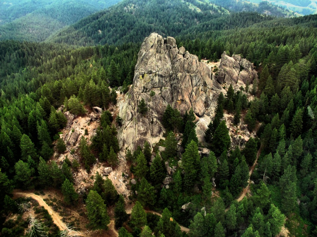
Big views off the high ridge on the Sawpit Mountain Loop
The Hikes:

1. Silver City Sawpit Mountain Loop - It's an 8-5-mile loop that circumnavigates a timbered mountain with a bald pointy cap that looms over Silver City in the high-elevation community in the Owyhees. It's rated moderate to strenuous. The fall colors in Silver City should be starting to happen anytime! I wrote about this hike last fall for Idaho Press Outdoors. Please see my story for directions and details. 

On a clear day, you can see a long ways across the Snake River Plain from the top of Bruneau Dunes 
2.  Bruneau Dunes State Park, south of Mountain Home - Take the kids and go play in the sand. Take your camping stuff if you're so included (check on space with IDPR). Easy to do in a day trip or overnight. Bruneau Dunes has a 470-foot high sandy mountain inside the park. Take a hike on the ridge of the dune. People also try to ski and snowboard the dunes. It's always a cool place to explore. 

3. Charcoal Gulch, Idaho City - Take a drive to Idaho City and go for a nice colorful hike on the Charcoal Gulch Trail, just on the outskirts of town. Find the trail by the Idaho City Airport (ever been there?) on the south side of town. There's a little trailhead on the north side of the airport. Take the Buena Vista Trail along the edge of the mountain, and then you'll see the junction for Charcoal Gulch. There are aspens and pines along the way, plus a small creek.  


Charcoal Gulch Trail weaves through ponderosa pine trees and aspens near Idaho City. (Courtesy Visit Idaho) 
4. Freddy's Stack Rock Trail - Stack Rock is a signature granite pyramid-shaped rock on a timbered ridge to the west of Bogus Basin Mountain Resort. It's a 9.5-mile hike or bike ride from the trailhead to do the loop around Freddy's Stack Rock Trail. I would rate the hike/ride as moderate to strenuous because of a number of continuous uphills along the way, the distance and 2,600-vertical-foot gain/loss. You're walking/riding in the pines throughout the route, except when you get to Stack Rock, so that makes it scenic and intimate. Take a lunch to enjoy on Stack Rock.

Image result for stack rock
Photo courtesy of Tom Lopez
Backstory: Approximately 1,300 acres of the Stack Rock area came into public ownership courtesy of a $1 million donation by Boise resident Fred Alleman and additional funds from the Boise Foothills Levy Committee. The land was purchased from the Terteling family in December 2009 for $1.32 million to make it available for public use.
Directions: Park in a major pullout on the left as you're heading to Bogus Basin after the road passes the turnoff to a number of cabins on the left. It's a very popular trailhead in the summer. Watch for it at about Mile 12 on the left. A new parking lot has been built up there for the Eastside trailhead on the right side of the road, too. Either works.


You'll see a number of nifty bridges on the Dry Creek Trail ... keeping your feet dry.
5. Dry Creek out and back, Boise Foothills - Dry Creek is always a pretty hike, but especially right now, it should be great. The trailhead is off of Bogus Basin Road, several miles up from Boise, on the right side, as the road begins a series of hairpin switchbacks. You'll see other cars at the trailhead. It's a big day to hike to the top of the Boise Ridge via Dry Creek (7.5 miles, 2000+ vertical feet), so just take your time and go as far as you want. 

The City of Boise is hosting some events to celebrate the 50th anniversary of the Boise River Greenbelt, including the unearthing of a time capsule today and a fun walk/run on Saturday. See the Facebook event page for details.

Have fun!
- SS 

Thursday, September 12, 2019

Here's 5 hiking loops to enjoy during the Hyde Park Street Fair

Boise city scape from the trails to the Camelsback Summit.
Exhibitors getting set up for the weekend!
Boise Byrds biking group heading out for a ride.
Hi all,

Everyone knows the Hyde Park Street Fair is a rockin' good time, and it's happening Friday-Sunday of this weekend, Sept. 13-15.

It's always a hoot to hang out with your friends at the street fair, run into other peeps you know, shop the booths and enjoy the music. See the Boise Weekly article for all the details. It's the 40th anniversary of the Hyde Park Street Fair! 1979 man - Wow!

For my outdoor tip of the week, I'm recommending five hiking-biking-running loops that start and finish at Camelsback Park to maybe knock out before you go to the fair, knowing that you might be enjoying an alcoholic beverage or two ...

This list is kid-friendly and family-friendly, starting with the easy and building from there.

Trail to the top of Camelsback hill
1. Kiddie hike to Camelsback summit - Distance: 1/4 mile; Difficulty: Easy. There are several trails climbing to the top of Camelsback Summit from different sides of the park. One of them marches straight up the face of the hill in a series of steps. Take your young kids to the top to get a great view of the park and the city. When the music is playing, and the park full of colorful people, it'll be way cool to take in the event from up there. Best for kids 2-5 years old. Tip: there's a sand pit on the east side of the Camelsback hill, accessible from the trailhead on the east side of the tennis courts, where little kids love to play.

Walkers and runners headed out on Red Fox Trail.

2. Red Fox - Owls Roost Loop - Distance 2.3 miles; Difficulty Easy. Hiking time: 45 minutes (brisk pace) to 1 hour. This is the shortest and flattest loop from Camelsback Park venturing into the foothills. But it's very scenic going up Red Fox #36 Trail and coming back on Owls Roost (watch for great horned owls in there). Start from the trailhead on the east side of the tennis courts, and hike up Red Fox Trail 1 mile. Cross 8th Street, and take Kestrel a short ways to the Owls Roost junction. Turn right and return to Camelsback on Owls Roost.

3. Kestrel - Red Cliffs Loop -Distance: 5 miles, starting from Camelsback; 3 miles, starting from the Foothills Learning Center. Difficulty: Moderate. Hiking time: 2+ hours from Camelsback; 1+ hours on the short loop. Vertical gain: 606 feet. This hike is a great little workout close to home. Take Owls Roost out of Camelsback about 1 mile to the Kestrel junction. Turn right and climb Kestrel on the ridge up to Crestline Trail. Go left on Crestline a short ways and then turn left on Red Cliffs to return to the Learning Center and Camelsback. Great views from those trails, too, once you're on Crestline, and on the way back on Redcliffs.

4. Crestline - Hulls Gulch Loop - Distance: 7.25 miles, starting from Camelsback; 5 miles from the
Foothills Learning Center; Difficulty: Moderate with strenuous pitches. Hiking travel time: 2.5-3 hours; Running travel time: 1.5 hours; Vertical gain: 868 feet. Crestline-Hulls is a classic loop in the Central Foothills. It may be one of the most popular loops, if not THE most popular loop, because it’s a great tour in a scenic setting. Starting from Camelsback, take Owls Roost Trail about 1 mile to Kestrel. Turn right on Kestrel. The climb up Kestrel is steep in places and fairly continuous on the ridge, but once you're on Crestline, the gradient is very gradual and moderate on a wide sandy trail all the way to Hulls Gulch. The rocky singletrack trail going down Hulls creates a little more entertainment, but it's no big deal for hiking. Just watch your step! 

5. Corrals - Hulls Gulch - Loop - Distance: 8+ miles, starting from Cameslback. Difficulty: Moderate with strenuous sections. Vertical gain: 1,000 feet. This one requires a shuttle if you're hiking. It's a piece of cake if you're riding this route on a mountain bike. But it's a great tour from Corrals, over Corrals Summit to Bob's Trail then over to 8th street, cross 8th, and down Hulls Gulch back to Camelsback. You could hike up Highlands Trail from the bottom of Bob's in the Highlands to catch Corrals Trail, or start at the Corrals Trailhead 1.2 miles up Bogus Basin Road from Highlands Elementary. Proceed on Corrals Trail over the summit to Trail #1 to 8th Street. Cross 8th Street and descend on Hulls Gulch. Best for mountain biking, but it's a great hike or trail-run too! 

Have fun! 
- SS