Thursday, March 22, 2012

Here's a hodge-podge of Idaho outdoorsy things to do this weekend or on spring break

Bruneau Dunes State Park
Great views when hiking in Succor Creek State Park
Leslie Gulch has many unique rock formations
Pruitt's Castle on the Lower Owyhee River
Big white sandy beaches on the Salmon River
Hells Canyon!
A Cooper's hawk
Hikers, runners and mountain bikers were everywhere in the Boise Foothills Thursday evening.

Hi all,

Oh. my. word. Suddenly the weather shifts to the dry and warm side in the Boise Valley for two days, and the trails are trying out rapidly in the Boise Foothills. You can bet the same thing is occurring in the Snake River canyon and the Owyhee foothills.

Wendy and I took our puppy "Huck" on the Kestrel-Red Cliffs loop in the Boise Foothills on Thursday evening, and the trails on the 5-mile loop were bone dry. We loved feeling the warm sunshine on our faces, hiking comfortably in shorts, and seeing all of the hawks and songbirds. We saw a pair of Cooper's hawks, kestrels, bunched-up robins migrating through, the sweet call of meadowlarks, and many other birds flying around. Spring is here! Yay!

The weather is looking fabulous this weekend, with temperatures pushing into the low 70s. It was in the low 60s today (Thursday), and it felt like 80. That will open up the possibilities for lots of things.

Here are some Idaho staycation suggestions for the weekend and Spring Break:

  • Outdoor multitasking mania - It's that time of year when you can sneak in a little spring skiing in the morning at Bogus Basin, and then go play golf, tennis, road biking, mountain biking, or kayaking/rafting on the Payette River in the afternoon. You could probably work in more activities than that if you're creative. See my previous blog on the topic.
  • Camping in the desert. With temperatures warming up quickly, it should be safe to go camping in the Snake River canyon below Swan Falls Dam, at Succor Creek State Park, Leslie Gulch or on BLM lands on the front side of the Owyhees. A high-clearance 4WD vehicle is recommended, because there is still a chance of rain in the forecast. You just never know this time of year.
  • Go camping at a developed campground in the desert. If you'd like to pick a sure thing, head for Bruneau Dunes State Park and hike around on big sand dunes. It's a great spot for families and kids. You won't get stuck on muddy dirt roads here ... the park roads are all paved.
  • Spring beach camping on the Salmon River. Maybe you didn't plan a trip to Mexico or Bora Bora this year. But you can still sift sand through your toes on the banks of the Salmon River, 10 miles upstream of Riggins or more, there are many beaches to consider for camping. Do a little day trip rafting, kayaking, steelhead fishing or hiking on the Wind River Trail.
  • Spring hiking, camping or backpacking in Hells Canyon National Recreation Area via Pittsburg Landing, near Whitebird. See my previous blog about this trip. Hells Canyon is usually the warmest spot in Idaho.
  • Float the Owyhee River. The Owyhee was flowing only 1,200 cfs as of Thursday evening, but this warm weather will bring it up some more. I bet there will be some early-birds launching on the Lower Owyhee River tomorrow or Saturday. See my previous blog on this topic.
  • Go corn skiing in the backcountry. Go early before the snow gets too sloppy. Banner Ridge, Pilot Peak, Sunset Mountain, Copper Mountain and Stargaze yurt are all good locations for backcountry skiing and snowboarding. Bring plenty of sunscreen!
  • Float the Payette River. The North Fork of the Payette River was cranking Thursday afternoon (we had a good glimpse on the way back from McCall) at 1,700 cfs, and the Main Payette was runnign at 3,400 cfs. There will be some early birds floating Cabarton in the snow, and a bunch of rafters and kayakers on the Main Payette. Spring boating is happening.
  • Go steelhead fishing on the upper Salmon River between Corn Creek and Stanley. There are only a few weeks left in the season, and the fish are moving upstream to spawn. The nice weather should make for especially nice conditions for steelhead fishing. Check the Idaho Outfitters and Guides Association web site for a guide, if you need one.
Hopefully those ideas will inspire a little adventure!
- SS

Thursday, March 15, 2012

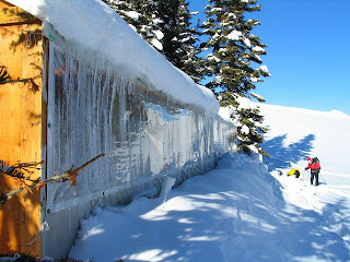
Tornak Hut near Sun Valley is one of my favorite backcountry huts in Idaho

Almost there ... the final climb to the hut.

Here's Steve skinning up the slope in the first couple miles.
Clear windows on one side make for fantastic views ...

The dining area inside the hut.

Todd Haylett and Paul Hilding hang out in the sunshine inside the hut.

Looking across to some north ski glades.
Peeling out to ski for the day.

Hiking up to the knob above the hut.

Mack Lyons and Paul Hilding on the trail.

Hi all,

We had the privilege of spending three days at the Tornak Hut north of Sun Valley on a sunny and warm March weekend. Most of our group of 7 brought Hawaiian shirts for the spring skiing occasion, and it was totally appropriate.

Tornak has been one of my favorite huts for a long time. It's owned and operated by Sun Valley Trekking, which has a total of six huts and yurts in the Smoky, Pioneer and Sawtooth Mountains. Since I make a point of doing yurt/hut trips every winter, I've had the privilege of staying at all of S.V. Trekking's huts and yurts over the years, and I can tell you that Tornak is positively deluxe! Think about trying to reserve it for a group of your friends next year.

The hut is a super-long double-wall tent. It's really spacious. It sleeps up to 14, but a party of 10 would be perfect. We had a party of 9 until two of our friends had to bail, so we went with 7. There is a wood stove on each end of the hut. One end is reserved for sleeping, and the other for cooking. The kitchen area is nice and roomy with a large dining table and chairs for hanging out, and a comfy space for cooking.

One entire side of the hut has clear plastic windows for looking at the Boulder Mountains from inside the hut. That's a great feature. Tornak also has one of the best saunas you'll find anywhere. We fit nearly all of our group in the sauna at once. It takes about 1.5 hours to get the stove in the sauna really cranking, and then you'll sweat away all of the impurities from your day of skiing, and then you can dive in the snow, towel off in the chilly evening air, whatever.

Tornak also has excellent skiing or snowshoeing terrain very close to the hut. It's located at 8,400 feet in a protected nook just below a saddle. After breakfast, you climb for 5 minutes to a little knob behind the hut, and marvel at a huge number of bowls that you can ski, depending on what aspects have the best snow. And then go for it!


Because we were there on a warm and sunny weekend, with highs in the upper 40s, we had to hit the east and south slopes as soon as the crust was softened by the morning sun. The west slopes warmed up a little later in the day. The north slopes still had good powder on them in the shade, but breaking trail in the deep, sugar-like snow was kind of a bear in places. That's the breaks.

Getting into Tornak is probably the biggest challenge. It's only four miles, but the climb features 1,400 vertical feet of gain. You park at Easley Hot Springs, about 10 miles north of Ketchum, ski over to a canyon, and start an abrupt climb up a steep slope. You feel the weight of your backpack right away. Several of our crew members got really bad blisters on the climbs.

After the first 30-45 minutes of climbing, the steepness moderates, and you follow a ridge to a snowmobile road, and then climb gradually for another 1.5 miles to the hut on the snowmo road. My friend Mark and I made it to the hut in less than 3 hours. I remember when I was younger we used to get in there in about 2 hours.

Because of the snowmobile road access, it's possible to have Sun Valley Trekking carry some of your gear or all of it to the hut via snowmobile. The hut also is a popular destination for people with disabilities because of the snowmobile access, and they've redone the floor in the hut, so it's nice and flat for moving around in a wheelchair inside. How cool!

A lot of folks in the Treasure Valley focus their attention on renting the Idaho City Park n' Ski yurts during the winter. I'm suggesting to the backcountry skiers/riders and snowshoers out there that you might try spreading your wings and consider the Sun Valley Trekking huts and yurts as well. They're popular, but they don't fill up as fast as the Idaho City yurts. I booked Tornak for my group last November.

Here's some quick perspective on the other SV Trekking huts/yurts:
  • The Boulder yurts are close to the highway, with decent skiing close by. Probably the best option of all of them for taking young kids or people who can't go very far. SV Trekking will bring a catered dinner to your door at this yurt.
  • The Pioneer yurt in the Pioneer Mountains is a long trek, about 7 miles if I recall. Snowmobile assist is available. Skiing terrain is somewhat limited because of west aspects next to the yurt. But if you look hard, you'll find good snow. Spectacular mountains, Hyndman and Cobb Peaks, loom above the yurt.
  • The Fishhook Yurt is an easy to get into from the turnoff on Idaho 75 to Redfish Lake. Another good option for kids and people who can't travel too far. You have to ski quite a ways to find good skiing above the Fishhook Yurt.
  • The Bench Lakes hut is about 5 miles from the same trailhead as Fishhook. It's a pretty tough climb in there, but once you're there, it's awesome. There is great skiing directly above the hut, more skiing on "the triangle" on a flank of Heyburn Peak, and more skiing above the upper Bench Lakes. SV Trekking reports that Bench has been redone, and now it sleeps 20. If it's anything like Tornak, it will be stellar.
  • Coyote Yurt is 7 miles in from the same trailhead as Tornak, so it's about 3 miles farther to go than Tornak. Snowmobile assist is available to carry some of your gear. That's a nice feature because it can be a long slog to Coyote. Once you're there, it's got great skiing all around the yurt.
If you'd like to reserve any these huts for winter or summer, contact Sun Valley Trekking. Guide service is available, and you also could put together a hut-to-hut trip in several locations.
Enjoy!
- SS

Thursday, March 8, 2012

Warm weekend should be perfect for road biking in Boise; 5 rides to get you started

Serious riders on Hill Road

The Boise River Greenbelt ... lovely place to ride.

City to Farm loop skirts Kuna in SW Boise. This is Cloverdale.

Beautiful Ten Mile Valley ... between Cloverdale and Pleasant Valley Road

S. Cole has pretty much ZERO traffic, south of Ten Mile ...

Classic ranchette in the sticks outside of Boise
Hi all,

With the weather warming up this weekend into the low 60s, it's going to be a great weekend for just about anything, including spring skiing.

A lot of folks will want to go biking, and I'm promoting some cool road rides to get your cycling legs in shape again. Mountain biking in the foothills is tempting ... I saw a lot of riders out last Monday walking my dog. But hey folks, there are a number of wet and muddy spots on the north slopes of trails that won't dry out for a while. Please give the foothills trails a break and go road biking instead.

Check the Ridge to Rivers web site for the latest details. Their motto right now is "Know Before You Go." A voluntary closure is in effect for these specific trails after 10:30 a.m.

Here's an incentive to get psyched about road biking this spring. How about training for the BLUECRUISE of Idaho? It's sponsored by the Blue Cross of Idaho Foundation for Health, among others, and they have distances for any ability -- 15 miles, 30, 50 and 100. I'm hoping to do the century ride. The ride occurs on Saturday, June 23. Proceeds always go to a good cause.

Here's a mix of road biking suggestions for this weekend and beyond from my Boise Road Cycling Guide:
  • Start out nice and easy - take the Greenbelt out to Discovery Park from Municipal Park near Idaho Fish and Game's Nature Center. It's 9 miles one-way, 18 miles out and back. If that seems too far, try going from Municipal Park to Eckert Road by Lucky 13, and loop back via Barber Park and ParkCenter. That one is 10 miles total.
  • Spin it on Hill Road - Saw a ton of riders on Hill Road last Sunday as I was coming back from McCall in the late afternoon. Hill Road has a good shoulder, and you can ride as far as you want, going west. From Boise, you can ride west to Eagle, or keep going to Star for those who have riding all winter. It's 40 miles out and back to Star. Wind will be a factor.
  • City to Farm Loop - This is a cool ride starting at Overland & Five Mile and exploring Boise's agricultural roots, golf courses and subdivisions in Southwest Boise. This one is 16.2 miles and takes about an hour. You go south on Five Mile to Lake Hazel, turn right and go to Cloverdale, go south on Cloverdale to Columbia, right on Columbia for one mile, then south on Eagle to Hubbard, right on Hubbard for one mile, right on Locust Grove for two miles to Lake Hazel, go right and cut over to Five Mile, and go north on Five Mile to the start/finish.
  • City to Farm modified - I rode a 25-mile version of City to Farm yesterday from the same starting point. The great thing about riding in this area is that there is almost NO TRAFFIC. I took Five Mile south to Lake Hazel, turned right on Lake Hazel for one mile to Cloverdale, then left on Hubbard to Ten Mile, and rode that beautiful open valley to South Cole. Then I went south on Cole to Kuna-Mora, right on Kuna-Mora to Cloverdale, and retraced my tracks back to the start/finish. The NW wind was a real bear yesterday for the way back, but I don't think it's going to be that windy this weekend.
  • Cartwright - Three Summits Loop - Once you've worked in your legs (and butt) on the flats, it's time to climb. This loop is about 18 miles and takes about 1.5 hours at a recreational pace. It's also fondly called the "Dump Loop," because it goes by the Ada County landfill. It features several in-your-face steep climbs on Cartwright. It's easier to ride clockwise, than counterclockwise. Start at Hill and Bogus Basin Road. Go west on Hill to Seaman's Gulch. Go right and climb Seaman's Gulch past the landfill over to Hidden Springs. Turn right on Dry Creek Road and enjoy a spin through that valley and then climb the first big hill on Cartwright to Pierce Park. Go left and climb the next hill (short but kind of steep), and then enjoy a really fast downhill past the Owyhee Motorcycle Park. Gear down for the last hill to the initial Cartwright summit, and zoom down past the LDS church to Bogus Basin Road, turn right to the start/finish.
Here are a couple of bonus rides (which I've videoed) for consideration:
  • Lake Lowell Loop - 26 miles. It's a pretty easy ride with no significant hills (380 feet of verticle climbing the whole ride), and you circumnavigate Lake Lowell and enjoy the bird life. Start and finish at the Lake Lowell Boat Ramp. See the Boise Road Cycling Guide for directions.
  • Big Freezeout - Little Freezeout Loop. This one is about 40 miles, and it involves more than 1,000 feet of climbing/descending, but none of the hills are steep, just kind of rounded. Starts and finishes in Star. Because of the heavy commuter traffic on Idaho 16, I'd only do this one on a Saturday or Sunday. Beautiful tour of the Emmett Valley.
A quick word about the Boise Road Cycling Guide if you haven't seen it. It's a full color, two-sided foldout map with Olympian Kristin Armstrong on the cover. The map features more than 30 rides in the Boise Valley. It's waterproof and tear-proof. It costs $12.50, and it's available at nearly all of the cycling stores in town, and it's available on my web site, www.stevestuebner. It's the only road biking map available for the Boise area.

Have a good ride!
- SS

Thursday, March 1, 2012

Ol' Reliable Rocky Canyon Road is a great destination anytime of the year in Boise

Rocky Canyon Road at Aldape Summit early-season

Rocky Canyon Road map (click to enlarge)

Five Mile-Orchard (Trail #7) Loop (click to enlarge)

Five Mile Creek is a perennial stream

Orchard Gulch trailhead

Five Mile Trailhead

Goggles are a must riding in the snow

5-6 inches of fluff this morning!

I wasn't the only person who wanted to recreate in the snow ...

Hi all,

We're getting a nice blast of snow this week to freshen up the "pow" in the mountains, but next week, even by Sunday, the weather is turning warm in Boise ... it might even hit the low 60s by next Monday! That'll get the spring fever going, won't it?

The big swings in temperatures we'll be experiencing next week will freeze our foothills trails at night, and thaw big-time during the day; chances are, they'll be mushy by the afternoon when temperatures rise into the 40s or 50s. I doubt things will dry out yet, so you'll be limited to hiking/running/biking on frozen trails early in the morning.

During times like this, I've always championed going out on Rocky Canyon Road, a place we might call "Old Reliable" because it's a sandy dirt road with relatively good drainage. By using the road, you can't hurt it by hiking, biking or running in any condition. And it's always a good workout going up to the summit or hitting a few side trails or loops.

In case you're new to town, Rocky Canyon Road is part of the locally famous Race to Robie Creek, one of the toughest half-marathons in the Northwest. The section of Rocky Canyon I'm talking about starts at the end of the pavement and climbs 1,728 feet over 4.9 miles to Aldape Summit. Out and back, it's about 10 miles.

Today (Thursday, March 1), I went out to bike up Rocky Canyon in the snow, and it was totally beautiful -- light snow coming down hard, no wind, totally quiet and my tires made no noise in the soft snow. I thought I might have the place to myself, but there were several runners out there with dogs having a blast. See what these women had to say about their outing ...


Last Sunday, Wendy and I took our puppy, Huck, on a hike up the Five Mile Trail. I thought the trailhead would be below the snowline, which it was at the time. The trail is pretty sandy, so it was fine for hiking. After we hiked up the trail a ways, it was covered in snow or a combination of snow and ice to the Watchman/Orchard Gulch junction, where we turned around.

With the fresh snow, the Five Mile-Orchard Gulch Loop should be a beautiful hike or run in the next couple of days. This is a premium side trip in Rocky Canyon. The loop is 5.35 miles with about 1,100 feet of vertical gain/loss. Hiking time is approximately 2.5 hours, but if you're taking an easy-going pace, it might take longer than that. Running time is about an hour or less, depending on how fast you go. The route is featured in my book, Boise Trail Guide: 75 Hiking & Running Routes Close to Home.

I don't recommend Five Mile-Orchard as a bike ride right now unless you've got studs on your tires. But later after the trails dry out, this loop is an equally fun and sweet mountain bike ride. When things get warm in the next couple days, Five Mile and Orchard may get quite muddy, so this is another reason I'm not recommending it.

But there's Old Reliable Rocky Canyon ... you can always climb that, and try to reach Aldape Summit for an excellent workout. This can be very challenging this time of year because of snow, ice and slippery conditions, especially for a bike. I made it past the Orchard Gulch turnoff today, and after climbing maybe a half-mile past there, the snow was 5-6 inches deep, and I couldn't get enough traction on the steep road to keep going. I just kept spinning out, and it was about impossible to get going again.

But that's OK! I can come back another day and so can you! In the spring months, I've often been able to make it to Aldape Summit by riding a tight line (usually an icy or snowy tire track), and stay on that bead. Sometimes the best line is right next to the edge of the road. On the way down, it will be slippery and treacherous, but that's part of the fun. Be sure to lower your seat. And if you don't have fenders, you'll get lots of mud in the face and on the butt.

Runners and walkers don't have to worry about that part of it :) The Race to Robie Creek is scheduled for April 21 this year. There's no time like the present to start training. We saw a ton of walkers and runners on Rocky Canyon Road last Sunday. The runners I saw today went up to Orchard Gulch and did the loop on the way back down. They're already in great shape.

There will be some ice and snow to contend with near the summit for at least a month. But once the snow from today melts off tomorrow and Saturday, it should be possible to get there. I'll have to go back and see myself.

How to reach the trailhead: Take Reserve Street north off of Fort Street near the Fort Boise ballfields and St. Luke's Regional Medical Center. Reserve turns into Shaw Mountain Road at the end of the straightaway. Follow Shaw Mountain Road up the winding paved road to a junction with Table Rock Road and Rocky Canyon Road. Go left on Rocky Canyon. It's about 1.5 miles to the end of the pavement. See the maps above for more detail.

Have fun!
- SS