Showing posts with label geology. Show all posts

Wednesday, January 25, 2023

The Shoofly Oolites - A Geologic Wonderland in the Owyhee Canyonlands!

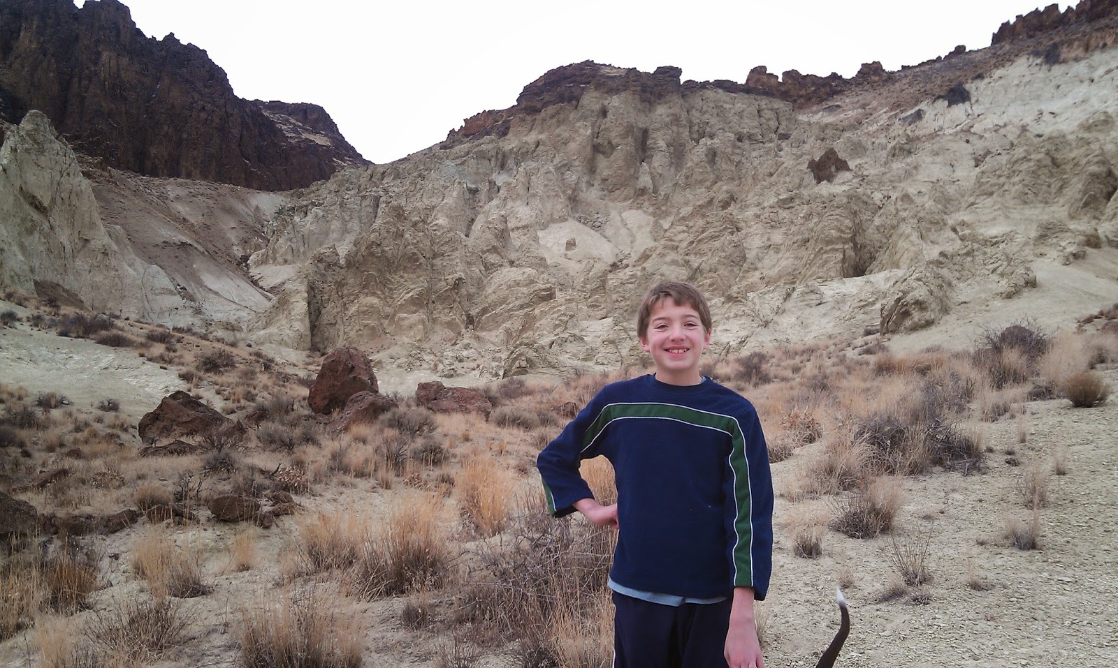
The author poses for a pic at the Shoofly Oolites. (courtesy Steve Schaps)

Guest Column
By Steve Schaps

The Shoofly Oolites are a geologic wonderland located about 60 miles southeast from Boise near Grand View, Idaho, at the foot of the Owyhee Canyonlands.

This location is probably the closest you can come to hiking on the surface of Mars. The hike is 1-3 miles in length. 

It is both dog friendly and kid friendly, so you can bring either one or both. This is a great place to bring kids or grandchildren. It’s about an hour’s drive from Boise, and a far less snowy or icy drive than if you were heading to the mountains to the north.

One of the main reasons to visit the Shoofly Oolites is the educational opportunity for kids and adults to learn about this geologic wonderland.


Oolites, known as “Egg Rocks,” are rocks made up of small round calcium carbonate deposits (not sand), which look like tiny BB-sized eggs. The Shoofly Oolites are one of the largest outcrops of Oolites in North America and possibly the largest freshwater Oolite accumulations on earth.

These Oolites were deposited in beach/shoal environments along the sides of ancient Lake Idaho around 2-5 million years ago in the Pliocene Era. Lake Idaho was in a large closed basin like the Great Salt Lake is today. It stretched from Eastern Oregon across most of the Snake River Plain, from Boise to the foothills of the Owyhee Mountains.

Most of the Treasure Valley’s groundwater and farm fields are in Lake Idaho deposits. It’s one of the reasons that the area has such abundant groundwater and agricultural resources.

Courtesy Steve Schaps 

The Shoofly Oolites are unusually thick, very homogeneous, and create an interesting area for a hike and geologic field trip. You can take home a few pieces of Oolite rocks, if you like. Bring a big. They are a bit crumbly.

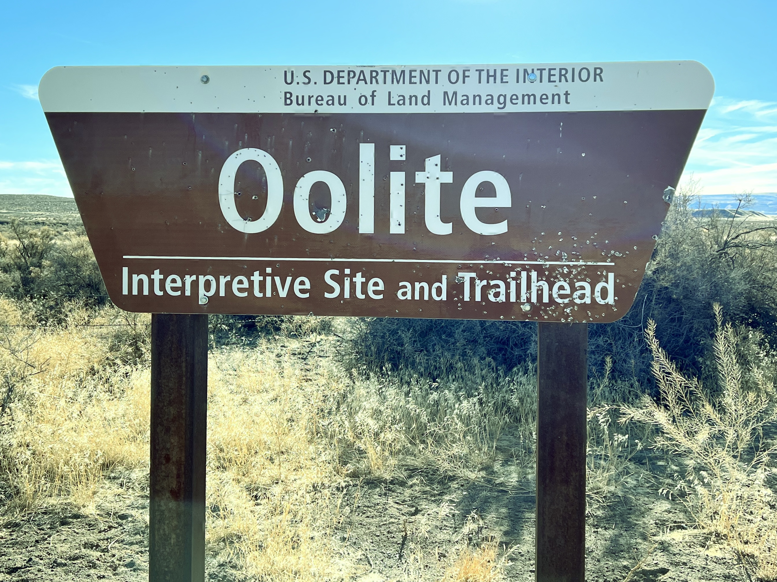
The Oolite road-side stop is managed by the Bureau of Land Management. It includes a few educational interpretive signs and a parking area.

There are lots of weird and interesting rock formations to see. The kids love this part … there are all kinds of caves, holes, arches and bathtub features to explore. A game of hide and seek, anyone?   

The Idaho Museum of Mining and Geology will be leading a geologic field trip to the Shoofly Oolites on April 16. Go to https://www.idahomuseum.org/ for more information.

There’s also a historic cemetery located one-half mile up the road that you can also explore.

How to get there:

·      Take I-84 east toward Mountain Home

·      Go right at Exit 74, Simco Road.

·      Follow Simco Road south for about 20 miles.

·      Turn right on Idaho Highway 167 and follow that to Grand View. Stock up on gas or any supplies at the Grand View quick stop.

·      Go left on Highway 78 and go east for about 2 miles to a Y-junction.

·      Veer right on Mud Flat Road, the Owyhee Backcountry Byway, a paved road to begin with, and follow that for about 9.5 miles. The Oolite BLM site is on the right. GPS coordinates are 42.837128/-116.121980.

Courtesy Steve Schaps 


Steve Schaps has a bachelor's and master's degree in Geoscience. He worked for over 30 years as a geophysicist in Houston, Texas. He's retired now. He's lived in Idaho for six years. Steve is also a volunteer at the Idaho Museum of Mining and Geology. 

Thursday, February 13, 2020

Discover scenic Sage Creek canyon in the Owyhee Canyonlands

Ready my story to learn more about the unique geology in Sage Creek canyon.
One of several waterfalls that you'll encounter in Sage Creek canyon.
Hi all,

My outdoor tip of the week is about a super scenic and secluded discovery hike in Sage Creek canyon, near Succor Creek State Park, just west of Homedale, Idaho, in Eastern Oregon. Wendy and I visited Sage Creek canyon about 10 days ago. It's one of our favorite early-season Owyhee hikes because it's readily accessible from a well-graveled dirt road.

Here's my trip report as detailed in an outdoors feature story for the Idaho Press. The trailhead is about 1.5 hours (driving-time) from Boise.

February is not too early to be thinking about hiking and exploring the Owyhee Canyonlands. In general, wait for a few days of dry weather before going out there to avoid muddy roads, etc. See more in my book, The Owyhee Canyonlands: An Outdoor Adventure Guide. 

The scene as you approach the bottom of Sage Creek canyon.
Have fun!
- SS

Thursday, March 23, 2017

Seize the day and plan a trip on the Owyhee River! You've got a little over a month to do it!

Wendy and Huck as we leave camp on Sunday morning ... the sun came out a few minutes later ... 
Now we can see some sunshine deep in the Owyhee River Canyon ... 
Caves to explore next to a potential camp site a few miles from the Birch Creek take-out
Hi all,

Spring is finally coming to SW Idaho after such a long winter ... and all of the luscious powder we enjoyed in the mountains is flowing down the mountains and into our favorite rivers. Last weekend, Wendy and I saw a decent weather window opening up last Friday-Sunday, so we seized the day and floated the lower Owyhee River, from Rome to Birch Creek, a 45-mile scenic trip just across the Idaho border in Eastern Oregon.

We had three rafts and six people. It's always cool to float with a small group when you're doing an impromptu trip. That makes the prep so much easier -- especially if you're going with experienced people who have all the necessary gear.

It's a 1.5- to 2-hour drive to the BLM put-in by the Owyhee River bridge on U.S. 95 in Rome. We stopped in Jordan Valley to buy 2017 invasive species permits at the hardware store. That was a smart move because an Oregon State Police officer was checking for them at the put-in ... didn't see anyone from the BLM.

We launched on a sunny day on Friday, with temperatures in the low 70s, and the river was running in excess of 6,000 cubic feet per second -- a sweet, fast flow. The Owyhee already has peaked this year in February, when it rocketed to 20,000+ cfs when we had that big warm up period, and rain on snow. That melted a lot of the low-elevation snow.

Last year, the Owyhee and the Bruneau rivers had a nice long season, but I was busy running off to my son's out-of-state hockey tournaments or work trips. So this year, I was not to be denied! And if you run the Owyhee in March, chances are you might be able to run it again in April or early May!

If you've always thought about running the Owyhee River, this is a great year to do so. The river may be peaking about now, according to the snow survey experts. The Mud Flat Snotel site has melted out, and more than 30 percent of the snow has melted from South Mountain -- those are the typical indicators when the river peaks, according to the experts. But the Owyhee should have boatable flows through April, and possibly early May, depending on how much more precipitation we get, how warm it gets and how fast the river runs off.


Why float the Owyhee? To see and experience the Owyhee Canyonlands, a vast landscape full of hidden caves, slot canyons, big canyons like the Owyhee River, spires, hoodoos and more. The scenery and geology are spectacular ... be sure to bring a book along like "Roadside Geology of Oregon," to learn about the volcanic episodes that dominated the Owyhee region for millions of years, plus the various basalt lava flows and rhyolite lava flows and outcroppings.

And bring your camera and video camera to document your trip.

For me, another key attraction is camping out on the river. It's so easy to haul all of that stuff on your boat, and you can camp in style with the big camp table, Dutch oven meals, lawn chairs, iced coolers full of your favorite drinks, and dry boxes to carry all of your dry goods.

I just love camp fire in the evening on a March river trip ... the regulations are to pack-in your own firewood.
The Rome-to-Birch Creek section is pretty friendly in terms of whitewater ... the rapids are mostly Class 2 and 3 on a scale of 1-6, with 6 being a steep waterfall. Because the river was moving so fast, and bank-full, we made great time on the water, traveling at least 5 mph without even trying to push downriver. With fast pushy water, however, you do need to anticipate your moves well in advance, and sneak the inside corners when you can see hazards on the outside corners when you're approaching rapids. Whistling Bird and Montgomery are typically the biggest rapids on the river, but at 6,000-7,000 cfs, Whistling Bird was super easy, and Montgomery was the typical pull to the right to avoid the wall and hole at the bottom.

The BLM has an excellent map booklet available that provides a mile-by-mile guide to the lower Owyhee River, as well as the other forks of the Owyhee and the Jarbidge-Bruneau. You can find the river map at the BLM State Office on Overland and Vinnell in Boise, or also at Idaho River Sports. I highly recommend it. The map marks all the rapids and the designated campsites.

If you don't have your own river gear, there are a number of outfitters that do Owyhee River trips, including Far & Away Adventures, Barker River Expeditions, Wilderness River Outfitters, and ROW Adventures. All of those outfitters are really solid and put on great trips! Be sure to get in touch and reserve a date before their trips fill up.

For vehicle shuttles, we used Eva Matteri, 541-586-2352. The cost was $160/vehicle. Well worth it!
-------------------
Notes: In case you missed the Facebook post earlier this week, my blog, Stueby's Outdoor Journal was selected as one of the Top 20 outdoor blogs in the Northwest by the Outdoor Authority. I thought you'd enjoy seeing some of the other blogs mentioned in the top list. They all sound really good. My friend Mike Lanza's The Big Outside always has quality content, featuring world-class trips and a lot of tips about outdoor gear.

Greenbelt underpass closures and flooding closures: If you're been looking for a comprehensive list of Greenbelt closures, the Statesman had a story in today's paper with the latest closures. The river is supposed to go up to 8,000 cfs today ...

Bogus and Brundage winding down: Brundage's last day of operation is Sunday, April 9th, with a pond-skimming event set for April 8th. The last day of operations at Bogus will be Sunday, April 16th. The last opportunity for night skiing is this Saturday. Nordic operations will close following this weekend as well.
- SS

Thursday, March 20, 2014

Spring has sprung in the Owyhees! Exploring Sage Creek a good bet for the weekend

Our kids mess around in the rocks above the draw ... 
Hiking into Sage Creek from the trailhead.
One of many caves you'll see in there.
Balanced-rock features are everywhere in the middle of the canyon.
Hi all,

The slighter warmer, spring-like weather has been excellent for hiking, running and biking in the Boise Foothills. People are loving it, and they're out there in big numbers! And for good reason, spring is a perfect time to get out hiking, biking and running! March-June also is the perfect window of opportunity to explore the Owyhee Canyonlands before it gets blazing hot in July and the rattlesnakes emerge.

This week, I'd like to feature a couple of cool hikes in the Owyhees in the Sage Creek area, near Succor Creek State Park. Sage Creek is featured in our new guidebook, the Owyhee Canyonlands: An Outdoor Adventure Guide. It's a low-elevation destination, with tons of unusual and colorful volcanic rock and ash formations, and it's a kid-friendly and family friendly hike.

This is what I said in the book: "Sage Creek is a hidden jewel chock full of spectacular volcanic rock and ash formations in the creek-bottom and on the mountainsides as you hike along the creek ... One of the key highlights in Sage Creek is that you'll encounter multiple balanced rock features, some of them obvious phallic-type symbols, as well as spires, cliffs, fins and caves."
My son, Drew, loved the hike. 
Our guide features a 2.5-mile exploration out-and-back hike, cruising up the bottom of Sage Creek (rated easy for all abilities), and a 6-mile hike up to the top of McIntyre Ridge from Sage Creek (rated moderate to strenuous), with nearly 2,000 feet of climbing. Both of them are great!

How to get thereTake I-84 to the ID 55 exit in Nampa, heading west toward Marsing. Go west on ID 55 and  and Turn right on Chicken Dinner Road, then left on Homedale Road, and go to Homedale. Follow State Highway 19 west of Homedale, and then Highway 201 in Oregon, to a signed turnoff for Succor Creek State Park on the left. Head south on the dirt road. It's 12.1 miles to the unsigned right-hand turnoff  for the Sage Creek Trailhead. There is a lone scrubby cottonwood tree at the turnoff. Follow the primitive two-track road over several creek-crossings to the trailhead .9 miles from the Succor Creek Road.   
Nice rhyolite cliffs with Wendy in the foreground. 
Road access challenge: 4WD high-clearance vehicle is required to reach the trailhead; multiple creek crossings are involved. It's possible, however, to take a 2WD vehicle to the Sage Creek road junction, and hike from there. Add .9 miles to the trip if you start from Succor Creek Road. 

Hike #1 - 2.5-miles out and back
Cruise up the creek-bottom of Sage Creek, picking your way up the draw as you like. Hike at least a mile upstream to see the balanced rock features on the mountainsides above the draw as well as many other interesting rock formations. The volcanic ash flows in the area have turned different shades of white, orange and green over time. These formations are very erosive ... you can scratch the ash with your fingernails. Wear shoes that can get wet ... I doubt there's much water in the creek-bottom, but you will encounter some pools along the way.   
Hiking down-canyon back to the trailhead.
Hike #2 - 6-mile loop
From the end of the road, hike up-canyon and cross the creek to the left side. At mile .2, climb up the left-hand draw. It's a super-cool hike through many rock formations as you ascend the draw. It's about 2 miles to the top of the saddle near McIntyre Ridge. Climb to the top of McIntyre Ridge if you'd like. This area overlooks Succor Creek State Park to the east and Three Fingers Rock and many other features to the west. On the way down, descend the ridge to the left of the draw you climbed up, and enjoy a cool hike down into the draw. You'll pass by the "official" balanced rock on your way into the draw. Turn right at the bottom of the draw, and hike back to the trailhead.

Family pic in Sage Creek. November 2012. Kind of rare to get our 4 kids together for a family hike!
L-R, Drew, Tom with our pointer Huck, Wendy, Elena, Quinn, Steve 
Camping notes: You could camp in the bottom of Sage Creek. Quiet spot. Self-support camping. You also could camp at Succor Creek State Park, which has a public rest room, very close by, but that will be much more crowded. If you'd like to explore some other areas, Succor Creek Road connects to Leslie Gulch, Three Fingers Rock and many other areas worth checking out in our guidebook. 

If you're looking for ideas about what to do over Spring Break next week, check out my blog from last year with many ideas for recreation and camping close to home

Have fun! 
-SS