Showing posts with label Owyhee Wilderness. Show all posts

Thursday, April 27, 2017

Weather warming up this weekend and next week! Time to head for the Owyhees!

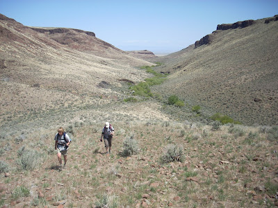
Jim Giuffre, foreground, Steve Schneider and Doug Lawrence just finishing the China Ditch Trail ... 
Sheep Creek Canyon cuts through old rhyolite lava rock 
Stopping to enjoy the grandeur of Reynolds Creek canyon. 

Hi all, 

The forecasts are predicting that we'll get a break from the rain this weekend, and next week the temperatures might hit 70 degrees F! OMG! Time to head out for a spring hike or bike ride in the Owyhees! Maybe take your camping gear and stay overnight? 

I just completed a 3rd printing of The Owyhee Canyonlands - An Outdoor Adventure Guide, so I've got plenty of books on hand if you haven't purchased your copy yet. The books are available on my web site, stevestuebner.com, Boise REI, Idaho Mountain Touring, Owyhee County Museum gift shop in Murphy, and Amazon

For this week's outdoor tip, I'll dish up two hikes and one mountain bike ride in the Owyhees. 

John Wheaton, Amy Haak, Wendy and me on
a winter ride on Bingo's Trail. 
First, the bike ride - the Wilson Creek - Northwest Passage Loop. Distance: 16.25 miles; travel time: 3.5-4 hours; vertical gain: 2,075 feet. Rated strenuous. Mountain bikers love this ride. It's almost all singletrack with a couple of short sections of two-track road. The Soda fire did a number on Reynolds Creek canyon, which some people feel has diminished the scenery. But I still think it's a great ride. 

See my blog post with photos, a map and blow-by-blow directions of the ride

Now, the hikes: 

1. Wilson Creek-Reynolds Creek Loop - Distance 7.4 miles; travel time: 3.5 hours; vertical gain: 750 feet; Rated moderate to stenuous ... mostly moderate. This is a shorter version of the Northwest Passage loop. Getting there: From downtown Boise, take I-184 west to Nampa. Take the Franklin Road exit (City Center) in Nampa, and turn left. Follow Franklin to the intersection with 11th Street. Turn right and take 11th into downtown Nampa. Follow signs for Idaho 45 south. Take ID 45 to Walters Ferry at the Snake River and turn right on ID 78, heading for Marsing. In a couple miles, turn left on Wilson Creek Road. Proceed up the paved road, past the cattle feedlot, until it turns to dirt and pull into a dirt parking area on the left, the trailhead for Trail #300. The hike starts here.

This is a great hike (good for trail-running, too) in the foothills of the Owyhee Mountains, about 45 minutes from Boise. The trail weaves through rock formations on the way over to Reynolds Creek, and then you hike the China Ditch trail along Reynolds Creek. The red rock canyon is spectacular. Bring your camera, plenty of water and a lunch. Even though the route is 7+ miles, the elevation gain is pretty minimal, so the hike may be suitable for kids 8 and over. My kids enjoyed the hike, especially throwing rocks into the creek.

Quinn hangs out on a big rock 
Directions: To begin, pick up Trail #300 out of the parking lot. Ignore trails branching off to the left in the first mile. At mile .9, you’ll cross a road and continue on the singletrack trail. The trail climbs one last hill and then widens into a two-track and descends to a T-junction at a dirt road (mile 1.8). Go right for a short bit, and turn left on Trail #410, a sandy wash going downhill towards Reynolds Creek. At mile 2.3, go right on Trail #310 and proceed for a half mile to a junction with Trail #600, the China “Ditch” trail. Go right and walk upstream along Reynolds Creek canyon for a long mile. After walking next to vertical rock walls, the trail opens up on the right at the junction with Trail #510, #601 and #610. Go right on #510 and climb out of the canyon. At mile 4, bear right at a Y junction on #510 and stay on #510 to BLM dirt road #37154. Go right and follow the road to the junction with Trail #400. Go left on #400 at mile 5.28 and head back to the trailhead. At the top of the first hill, you can either stay on Trail #400 or branch off on #300. Both ways head over to the Wilson Creek Road and the trailhead.

Sheep Creek canyon is deep! 
2. Mary's Creek to Sheep Creek Canyon - Distance: 8.75 miles; travel time: 4-5 hours; Vertical gain: 1,389 feet; Rated moderate to strenuous. This is a neat hike that takes you over to the deep incised canyon of Sheep Creek, where it's possible to camp by the creek or certainly stop and have lunch there before you head back. Mary's Creek also lies inside a BLM wilderness area, so this is a hiking-only experience. 

Road access: Easy, any kind of 2WD vehicle will work to reach this trailhead. 

Getting there: From Boise, take I-84 east to Mountain Home. Take the first exit to downtown Mountain Home. Proceed through town and watch for Idaho 51 to Bruneau. Turn left on Idaho 51 and go to Bruneau. Pick up any last-minute snacks/beverages and head south on Idaho 51. Check your odometer when you leave Bruneau. It's about 40 miles from Bruneau to the signed turnoff for Roland Road on the left, just past the old bar and junk yard in Grasmere. Go left on Roland Road, and take that good-quality gravel road 5.2 miles to the signed Mary's Creek Wilderness Trailhead. The hike starts here.   

General remarks: Mary's Creek is one of the more easy-to-access trailheads in the Sheep Creek/Bruneau Wilderness area. It's a scenic basalt canyon that drains into the much-deeper and spectacular box canyon of Sheep Creek. It's possible to do either a day trip here, or take a backpack and camp overnight at the Mary's Creek/Sheep Creek confluence, do some exploring and enjoy some quiet peace of mind. The day hike features a cross-country walk along the edge of Mary's Creek canyon for 3+ miles to the edge of the canyon rim. Then, there's a nice little singletrack hiking trail, called the Tindall Trail, that drops down to the confluence area, where there are several areas large enough for a campsite. We returned to the Mary's Creek Trailhead via a rough and rocky two-track road, just to make the walking a little easier. The two-track is drivable with a high-clearance 4WD rig, outside the wilderness boundary, if you want to drive directly to the canyon rim. I'd recommend this hike for kids who are 8-10 years old and up.       

Directions: To start, hike through the sagebrush along the left side of Mary's Creek canyon. It will get considerably deeper as you approach Sheep Creek canyon. At mile 3.6, you'll arrive at the canyon rim, where you'll see a singletrack trail winding through the rocks down to the Mary's Creek/Sheep Creek confluence. It's .7 miles and 520 feet of descent from the rim to the confluence. Great spot for lunch or overnight camping. Retrace your steps to the canyon rim, and take the two-track road back to the trailhead. Final mileage is 8.75 miles.

Have fun! Hoping for sunshine all weekend! 
- SS 

Thursday, May 2, 2013

Hiking tour of "Between the Creeks" in the Owyhees a great trip for families and kids


Robin Bjork has her field glasses ready to view wildlife 

Amy Haak's dog Pearl dutifully poses for a photo op; West Fork Shoofly in the background

Indian paintbrush 

Dropping into the East Fork of Shoofly Creek ... pretty easy going 

Springtime is the best time for this hike 

Hiking on our way out on the two-track road 

Final approach to the plateau

White splotch on rock indicates perching area by birds of prey
Climbing up to the plateau from the junction of the west fork and east fork
Aerial view of the plateau between the creeks 
Hi all,

This weekend is going to be perfect for taking a hike in the Owyhee Canyonlands. One of my favorite outings is an area called "Between the Creeks," a high plateau full of thrifty buchgrasses and wildflowers near Grand View, Idaho. This area is part of the new Owyhee Canyonlands Wilderness, and it's one of the easiest to access about an hour or so from Boise.

The plateau lies in between the West Fork of Shoofly Creek and the East Fork of Shoofly Creek. Both of them are scenic slot canyons, which you can explore while you're there, or just peer into them from above, your choice. While you're hiking on the edge of the canyons, you'll see white-splotched bird perches everywhere. Look for prairie falcons, hawks, gold eagles, pronghorn antelope and bighorn sheep. Be sure to bring a lunch and plenty of water to enjoy your day trip.
 
Like many trips in the Owyhees, the hardest part is finding the proper roads to reach the trailhead. And as part of the ongoing series of sneak-peek hikes and bike rides I've shared in my blog while we work on a guidebook for the Owyhee Canyonlands, I will tell you how to get there! The roads to this particular trailhead are not gnarly just a bit soft and lumpy... a Subaru or a vehicle with medium-clearance will work.

How to reach the trailhead: From Boise, take I-84 east to the Simco Road exit. Turn right on Simco Road and follow that to ID 167. Turn right and proceed to Grand View. In Grand View, fill up on any last-minute supplies and head east on ID 78. Watch for a major right-hand turn on Mud Flat Road. Note your mileage as you turn onto Mud Flat. Proceed 7.6 miles to the signed turnoff for Shoofly Cutoff Road. Turn left. Proceed 2.6 miles to an un-named dirt road on the right. Turn right on the dirt road and proceed south toward the Owyhee foothills. It's 9.7 miles to a BLM kiosk and parking area. Ignore side roads and stay on the main road heading for the hills. At the BLM kiosk, park if you have a low-clearance AWD. With a high-clearance 4WD, you can proceed another mile or so and park in a pull-out on the left or right. The road gets increasingly marginal from there.
The red lines are our GPS tracks from the hike. 8.1 miles total loop. Click to enlarge. 

Now the fun begins! I'm including mileage points on the hike, if you are carrying a GPS. Hike upstream along Shoofly Creek on the grassy two-track route to an old cabin at the junction of the east and west forks (Mile .9). Climb over a fence next to the west fork and climb the ridge on an old road bed toward the plateau. Follow the old road cut on a switchback to the top (Mile 1.55). Now you'll feel like you're on top of the world, with grand views of the countryside all around you.

Follow the rim along the West Fork and hike several miles to a high point. Pick your own route as you wish. I like to go back and forth to the rim to enjoy the views. At mile 3.8, you'll come to the top of a big hump that affords a sweet view of Perjue Canyon below. This was our half-way point and lunch stop. From there, we crossed the plateau over to the East Fork and walked that rim. The East Fork canyon is pretty but not as dramatic as the West Fork. Continue on the rim to mile 5.8, where there is a cut in the canyon where you can drop into the East Fork of Shoofly Creek. The walking is best in the crotch of the canyon. At mile 6.5, you'll arrive at the bottom of the East Fork. Walk downstream along the creek to the confluence (mile 7.2) by the cabin. Retrace your tracks to your vehicle (final mileage 8.1 miles). 


It also is nice to bring a plant or flower guide with you on this trip. I wrote about a super-cool new plant guide two weeks ago ... here's the link

For other explorations in the Owyhee Canyonlands, check out other blog entries in Stueby's Outdoor Journal, check out the BLM web site or read a comprehensive report from the Idaho Statesman about some hikes in the Owyhees from Thursday's outdoor page.  

BTW, John Robison of the Idaho Conservation League will be giving a presentation on introductory hikes in the Owyhee Canyonlands at 7 p.m. on May 22 at Boise REI. Go online or call 322-1141 to sign up. 

Some other pointers: 
  • Obtain a BLM map of the area you are visiting for the best results or print out a topo map. 
  • Avoid the Owyhees when it's rainy or wet. The roads can turn into quicksand. 
  • I always feel more comfortable when traveling with another group to remote locations in case one of the vehicles breaks down. 
  • When the weather gets hot, watch out for rattlesnakes. If you see one, walk around it, give it a wide berth, and you'll be fine. Don't try to mess with snakes. That's how most people get bit. 
Have fun! 
- SS 


Wednesday, June 15, 2011

An easy hiking trip in the Owyhee Mountains called the Shoofly Creek Quick Loop

Looking north toward the Snake Plain from a rock pinnacle

Bighorn sheep skull and horns


Jeep Trail makes for easy walking

Old cabin at the confluence of E. and W. Forks of Shoofly Creek

W. Fork Shoofly Creek

On the way into Shoofly Creek


"Between the Creeks" canyons come into view

The first canyon

Indian paintbrush was bursting with color everywhere


Hi all,

I mentioned a few weeks ago that I'm working on an Owyhee Canyonlands guidebook, and so this week, I'd like to highlight a cool 5.5-mile loop hike near Grand View, about 1.25 hours from Boise.

I'm going to call this hike the "Shoofly Creek Quick Loop" because it's a short drive to the trailhead on an easy and tame 4WD road off of Mud Flat Road (easily navigated with a Subaru), south of Grand View, and the hiking trip itself took me only about 3 hours. It's a family friendly trip ... kids 8 and over would do fine on the hike. Just so you know, the hike features 840 feet of vertical gain and descent over the course of 5.5 miles.

Why go: The hike penetrates a portion of the new Big-Little Jack's Creek Wilderness area in a spectacular area that's called "Between the Creeks" on USGS maps. The rocky canyons are very scenic, you'll see wildflowers, and you might see wildlife (I found a bighorn sheep skull and horns on my hike).

There is no official trail on this route, so you'll need some basic map-reading skills to complete the loop successfully. My route will take you up one short canyon in the Owyhee Front to the top of the plateau, and then less than a half-mile away, you'll discover a basalt and rhyolite crack that leads to the West Fork of Shoofly Creek. From there, you'll follow that fork of Shoofly Creek down to the confluence of the two forks, where you'll see an old cabin, and loop back to the trailhead (see trip map above).

Getting there: Take Interstate 84 east about 20 miles to the Simco Road Exit. Go south toward Grand View. At the junction with Idaho 167, turn right and go to Grand View. In Grand View, turn left on ID 78. In two miles, bear right on Mud Flat Road, known officially as the Owyhee Backcountry Byway. Follow Mud Flat 18 miles (past where it turns to dirt) and turn left on an unsigned two-track that runs along the foot of the Owyhee Mountains. Follow the two track for two miles, and it dead ends. The hike starts here.

From the trailhead, walk uphill and slightly to the right (southwest) and climb a small basalt canyon. As you near the top of the canyon at mile .6, you'll see that the main canyon cliffs out to the right. So you'll need to switchback to the left and climb up on top of the rim through one of the grassy gateways between the rocks.

Once on top of the plateau, you'll feel like you're on top of the world. Walk toward the southwest, and look for the canyon that drops into Shoofly Creek. Once you reach the edge of that canyon, you'll see the Between the Creeks plateau and the box canyons of each fork of Shoofly Creek. The only way into the crack is at the very top of it. You can scramble down through the rocks and follow the crack into Shoofly Creek.

At mile 2, you'll reach the West Fork of Shoofly Creek. Bear left and hike along the creek (don't cross). You'll climb over over a fence at mile 2.4, and you'll pick up a road next to the creek and follow that to the old cabin at mile 2.6. This is a nice lunch spot.

From the cabin, hike along the jeep trail until it crosses the creek at mile 3.1 (this was under deep water when I was there a couple weeks ago). Don't cross, and stay on the left side of the creek and wander downriver. The low-slung canyon rims along the creek get steep, so it's best to go above the rim and sidehill along the canyon and aim for a saddle by a pinnacle point overlooking Shoofly Creek. This was my lunch spot at 4.0 miles.

Drop off the pinnacle point toward the flats along the Owyhee Front and hike back to your rig heading directly to the west on the edge of the mountains. Final mileage is 5.5 miles.

- SS

Steve shares his weekly outdoor tips with Ken and Tim on 94.9 FM The River each Friday morning at approximately 7:10 a.m. If you miss the program, you can hear the segments on River Interactive.com. Detailed descriptions and color maps of Steve's hikes, bike rides and paddling trips are available for 99 cents each at www.stevestuebner.com, plus the full ebooks and hard-copy guidebooks.