 |
| Robin Bjork has her field glasses ready to view wildlife |
 |
| Amy Haak's dog Pearl dutifully poses for a photo op; West Fork Shoofly in the background |
 |
| Indian paintbrush |
 |
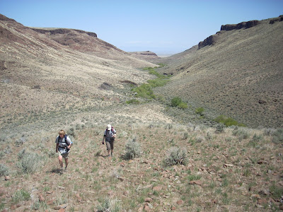
| Dropping into the East Fork of Shoofly Creek ... pretty easy going |
 |
| Springtime is the best time for this hike |
 |
| Hiking on our way out on the two-track road |
 |
| Final approach to the plateau |
 |
| White splotch on rock indicates perching area by birds of prey |
 |
| Climbing up to the plateau from the junction of the west fork and east fork |
 |
| Aerial view of the plateau between the creeks |
Hi all,
This weekend is going to be perfect for taking a hike in the
Owyhee Canyonlands. One of my favorite outings is an area called "Between the Creeks," a high plateau full of thrifty buchgrasses and wildflowers near
Grand View, Idaho. This area is part of the new Owyhee Canyonlands Wilderness, and it's one of the easiest to access about an hour or so from Boise.
The plateau lies in between the West Fork of Shoofly Creek and the East Fork of Shoofly Creek. Both of them are scenic slot canyons, which you can explore while you're there, or just peer into them from above, your choice. While you're hiking on the edge of the canyons, y
ou'll see white-splotched bird perches
everywhere. Look for prairie falcons, hawks, gold eagles, pronghorn antelope and bighorn sheep. Be sure to bring a lunch and plenty of water to enjoy your day trip.
Like many trips in the Owyhees, the hardest part is finding the proper roads to reach the trailhead. And as part of the ongoing series of sneak-peek hikes and bike rides I've shared in my blog while we work on a guidebook for the Owyhee Canyonlands, I will tell you how to get there! The roads to this particular trailhead are not gnarly just a bit soft and lumpy... a Subaru or a vehicle with medium-clearance will work.
How to reach the trailhead: From Boise, take I-84 east to
the Simco Road exit. Turn right on Simco Road and follow that to ID 167. Turn
right and proceed to Grand View. In Grand View, fill up on any last-minute
supplies and head east on ID 78. Watch for a major right-hand turn on Mud Flat
Road. Note your mileage as you turn onto Mud Flat. Proceed 7.6 miles to the signed turnoff for Shoofly Cutoff Road. Turn left. Proceed 2.6 miles to an un-named dirt road on
the right. Turn right on the dirt road and proceed south toward the Owyhee
foothills. It's 9.7 miles to a BLM kiosk and parking area. Ignore side roads
and stay on the main road heading for the hills. At the BLM kiosk, park if you
have a low-clearance AWD. With a high-clearance 4WD, you can proceed another
mile or so and park in a pull-out on the left or right. The road gets
increasingly marginal from there.
 |
| The red lines are our GPS tracks from the hike. 8.1 miles total loop. Click to enlarge. |
Now the fun begins! I'm including mileage points on the hike, if you are carrying a GPS. Hike upstream along Shoofly Creek on the grassy two-track route to an old cabin at the junction of
the east and west forks (Mile .9). Climb over a fence next to the west fork and
climb the ridge on an old road bed toward the plateau. Follow the old road cut
on a switchback to the top (Mile 1.55). Now you'll feel like you're on top
of the world, with grand views of the countryside all around you.
Follow the rim along the West Fork and hike several miles to a
high point. Pick your own route as you wish. I like to go back and forth to the
rim to enjoy the views. At mile 3.8, you'll come to the top of a big hump that
affords a sweet view of Perjue Canyon below. This was our half-way point and
lunch stop. From there, we crossed the plateau over to the East Fork and walked
that rim. The East Fork canyon is pretty but not as dramatic as the West Fork.
Continue on the rim to mile 5.8, where there is a cut in the canyon where you can drop into the East Fork of Shoofly Creek. The walking is best in
the crotch of the canyon. At mile 6.5, you'll arrive at the bottom of the East
Fork. Walk downstream along the creek to the confluence (mile 7.2) by the cabin. Retrace
your tracks to your vehicle (final mileage 8.1 miles).
It also is nice to bring a plant or flower guide with you on this trip. I wrote about a super-cool new plant guide two weeks ago ...
here's the link.
BTW, John Robison of the Idaho Conservation League will be giving a presentation on introductory hikes in the Owyhee Canyonlands at 7 p.m. on May 22 at Boise REI. Go online or call 322-1141 to sign up.
Some other pointers:
- Obtain a BLM map of the area you are visiting for the best results or print out a topo map.
- Avoid the Owyhees when it's rainy or wet. The roads can turn into quicksand.
- I always feel more comfortable when traveling with another group to remote locations in case one of the vehicles breaks down.
- When the weather gets hot, watch out for rattlesnakes. If you see one, walk around it, give it a wide berth, and you'll be fine. Don't try to mess with snakes. That's how most people get bit.
Have fun!
- SS


