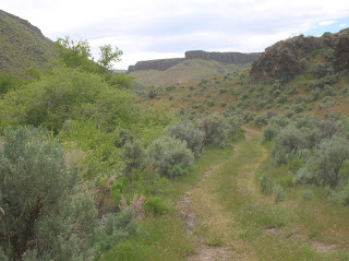
North Valley Rail-Trail in McCall

Red Ridge, near McCall

Jug Mountain Ranch trails, near Lake Fork

Loon Lake Trail, north of McCall

Loon Lake ... watch for moose!
Hi all, If previous years are any indication, there will be a max exodus of outdoor recreationists heading for the hills to go camping on this 4th of July weekend. For once, the weather looks absolutely fantastic.
Since many of you will be heading north toward Cascade and McCall, I'm recommending a number of snow-free trails, where you can go hiking, biking or trail-running in the Boise and Payette national forests. The snow level is at approximately 6,500-7,000-foot elevation; on north slopes, it will be lower.
However, some of my favorite trails in the area are snow-free. I'm glad that you'll be able to experience them. I'll start with a couple of easy ones and build to more challenging rides/hikes. Incidentally, all of these trails are featured in my book Mountain Biking in McCall:
- Crown Point Trail - Location: Next to Cascade Dam and Crown Point Campground. It's 3-miles out, and 3 miles back. Beautiful trail along Lake Cascade on a wide, dirt surface. Easy for all abilities. Nice for hiking and running, too.
- North Valley Rail-Trail - Location: South of McCall, starting from River Ranch on Mission Street, near the Forest Service Smokejumper Base. You also can start from downtown McCall, and pick up the paved trail heading south to the airport by McCall City Hall or McCall-Donnelly High School. The North Valley Trail is 3.5 miles long, and if combined with the paved trail, it's 5 miles out and back. Check out this YouTube video of yours truly riding the trail with my son. The trail is also a great place to hike and run.
- Eagle's Nest Trail - Location: East of Cascade off the Warm Lake Road. Distance: 13.1 miles. Advanced/expert ride. It's kind of a brutal climb up Forest Road #400 (2,800 vertical feet of climbing), but after you reach the singletrack, it's all downhill, and it's a blast. If you're hiking, start the hike on the singletrack by the big highway pullout 4 miles east of Idaho Highway 55. You'll see the sign for Trail #111. It's 7.7 miles one-way to the jct. with Forest Road 400 at 6,650-foot elevation.
- Loon Lake Short Loop - Location: 30+ miles north of McCall. Distance: 10 miles. Advanced intermediate ride. Drive Warren Wagon 30+ miles north of McCall, past Burgdorf Hot Springs, to Chinook Campground. The Loon Lake Loop is what I call "an Idaho classic," one of the top 10 rides in the state. I prefer to ride the loop counter-clockwise, but others prefer clockwise. The trail tread is all singletrack, with plenty of roots, rocks and steep climbs. Best-suited for advanced riders, but some strong intermediates can make it. Pack plenty of food and drink and make a fun day of it. Watch out for other trail users -- it's a very popular place to go.
- Bear Basin Loops - Location: McCall. Distance: Up to 5+ miles. Good for beginners on up. Local volunteers from the Central Idaho Mountain Biking Association have teamed up with the Payette National Forest to build a great little network of singletrack loops on very moderate terrain close to McCall. Individual loops are less than 5 miles, but it's fun to try to ride several of the loops, or all of them, if you have time. The trailhead is located north of McCall on Idaho 55. Turn right on a signed turnoff before the Little Ski Hill lodge. There are rest rooms at the trailhead.
- Red Ridge Loop - Location: North of McCall. Distance: 10.3 miles. Rated intermediate for hill-climbing and distance. It's a pretty easy ride in relative terms. The trailhead is off the Fish Lake Road, located next to the Little Ski Hill. Follow Fish Lake Road 1.2 miles. Turn left on the jeep trail going up the backbone of a ridge. Ignore the roads on the left and right. Spin up the ridge 4.8 miles, and then take a hairpin turn to the left (ignore right-hand turn to gravel pit), and ride a grassy two-track back to Fish Lake road.
- Jug Mountain Ranch Loops - Location: East of Lake Fork. The lower loops on Jug Mountain are snow-free. You'll need a map from Mountain Biking in McCall to navigate the ride, or better yet, go with someone who knows the area. (There are lots of trail junctions). The trailhead starts from the Jug Mountain Ranch clubhouse.
The Boise National Forest is reporting 6+ feet on top of Snowbank Mountain. If you've still got a yearning for backcountry skiing, you can drive to the top of Snowbank right now, go skiing and have a mountain-top BBQ. The dirt road to the top can be accessed from Cabarton Road, south of Cascade.
Have fun!
- SS
Steve shares his weekly outdoor tips with Ken and Tim on 94.9 FM The River each Friday morning at approximately 7:10 a.m. If you miss the program, you can hear the segments on River Interactive.com. Detailed descriptions and color maps of Steve's hikes, bike rides and paddling trips are available for 99 cents each at www.stevestuebner.com, plus the full ebooks and hard-copy guidebooks.


