Thursday, April 25, 2019

Try floating the Owyhee River with friends or an outfitter - it's spectacular!

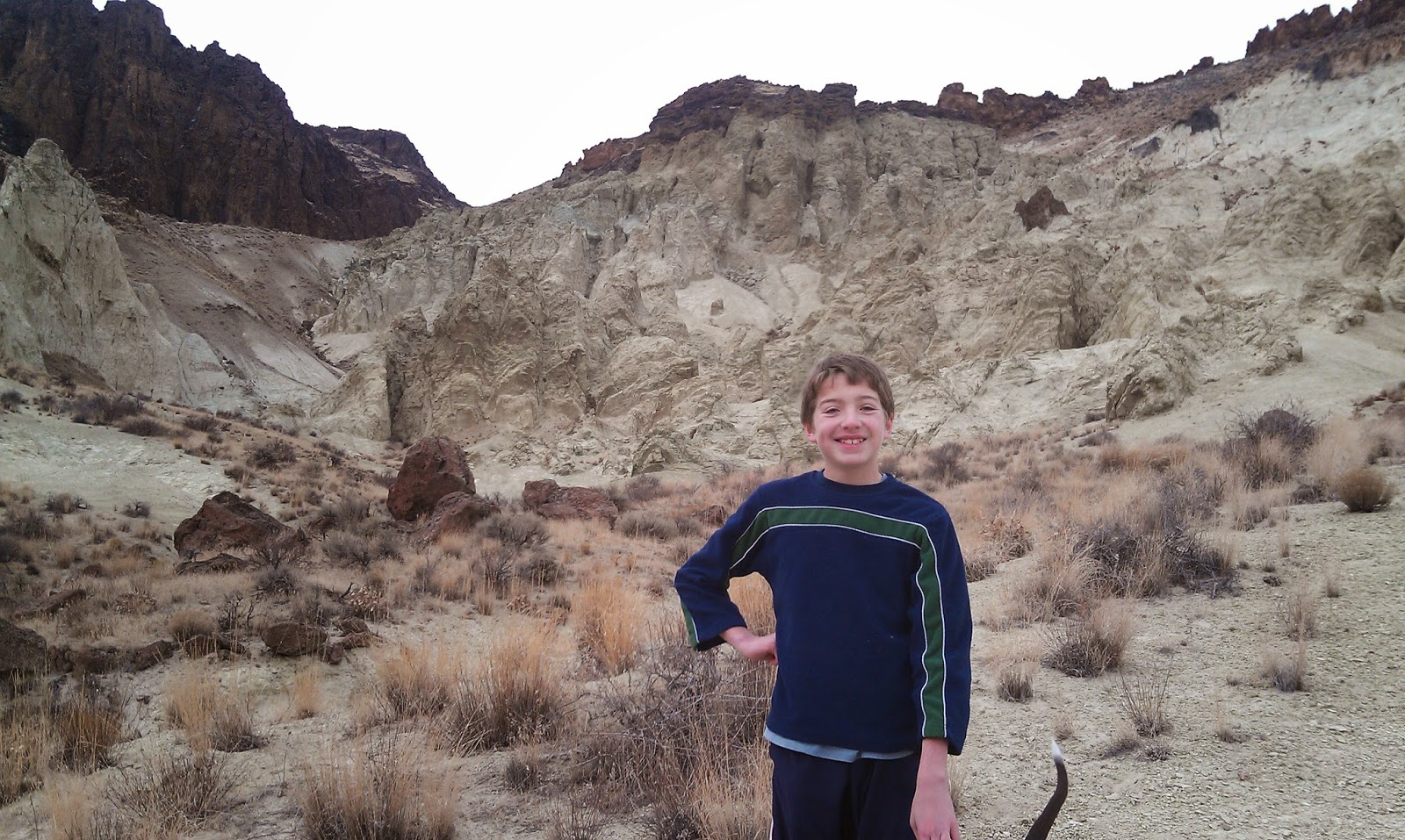
My son Drew is ready to roll at the Rome put-in for the Lower Owyhee River.
Bonnie, Rico, Kelley and Lawrence enjoy hanging out in camp on the afternoon of Day 3, below Montgomery Rapids.
Spectacular spot for our camp on night 3.
Hi all,

I managed to get out of town last weekend for a 4-day trip on the Lower Owyhee River. We launched on the warmest day of the year last Friday, when the mercury hit 80 degrees, and amazingly enough, there were a ton of parties launching on the river as well! Imagine that!
Because of deep snow in the Owyhee and Jarbidge-Bruneau river basins last winter, this spring offers a rare, and great chance to float those rivers when the water is high enough to go (April - June). If you don't have your own raft and whitewater gear, consider going with an outfitter. I'd recommend Far & Away Adventures, Wilderness River Outfitters, Barker River Expeditions, and ROW Adventures. Please see press release that I wrote for the Idaho Outfitters and Guides Association.
 
One of the big advantages of floating the Lower Owyhee is that you follow a paved road (U.S. 95) to the boat-launch site in Rome, Ore. To float the upper forks of the Owyhee, you have to drive for many miles on unimproved 4WD dirt roads that turn into major quicksand-like gumbo after lots of rain. So we had no worries about being able to reach the river last week, even though it had been wet.


Dad and Drew are bundled up on the morning of Day 3.
We took four days to float 48 miles to the Birch Creek takeout, upstream of Owyhee Reservoir. At a flow of 4,000 cubic feet per second (cfs), it should have been quite easy to make our river miles. But that isn't how things turned out. After a beautiful, warm and tranquil day on Day 1, we had driving rain, headwinds, thunder and lightning on Day 2. High temperatures were probably in the 40s. Then we had big headwinds on Day 3, but luckily, the skies were clear -- just a cutting Northwest wind. Good thing we came ready to dress very warm!

At 4,000 cfs, the river is comparatively wide and most of the rocks are covered. So from a whitewater perspective, it's a pretty easy and mellow level with good current and fun waves.

The Lower Owyhee has mostly Class 2 rapids, with a few Class 3's and one Class 4, called Montgomery. I would rate that Class 3+ personally. Montgomery is not that hard. You have to pull away from a left-side wall as the current races around a left-hand bend. It's a pretty straight-forward maneuver, compared to Class 4 rapids that require multiple maneuvers around rocks or holes.

We had four major highlights on our trip:
1. Birds of Prey were everywhere! Golden eagles, kestrels, northern harriers, prairie falcons and other hawks were flying around the cliffs, diving toward the water and nesting in the cliffs. Plus, we saw pairs of geese on virtually every corner, some with goslings, a few pairs of mergansers and some mallards.
2. Volcanic rock formations on the Lower Owyhee are spectacular. The types of rock spans from black basalt lava similar to the Jordan Craters, to rhyolite red cliffs, basalt cliffs and many spires, hoodoos and other formations. It's fun to just stare in awe at these features and feel small.
3. Recent rainfall and good snowpack made the desert landscape the deepest shade of green imaginable. We must have caught the green-up at its peak. But the flowers were just starting to pop because it's been such a late spring. 
4. Camping out, campfires, S'mores, great meals and great people. I love camping out in general, and we brought a bunch of firewood for a campfire every night in my fire pan. For the night I cooked, I brought all of the key ingredients for S'mores, and everyone really enjoyed that. I got to bring my son, Drew, along for the trip, and he's really turning into an excellent river camper. Great bonding time for Dad and Drew.

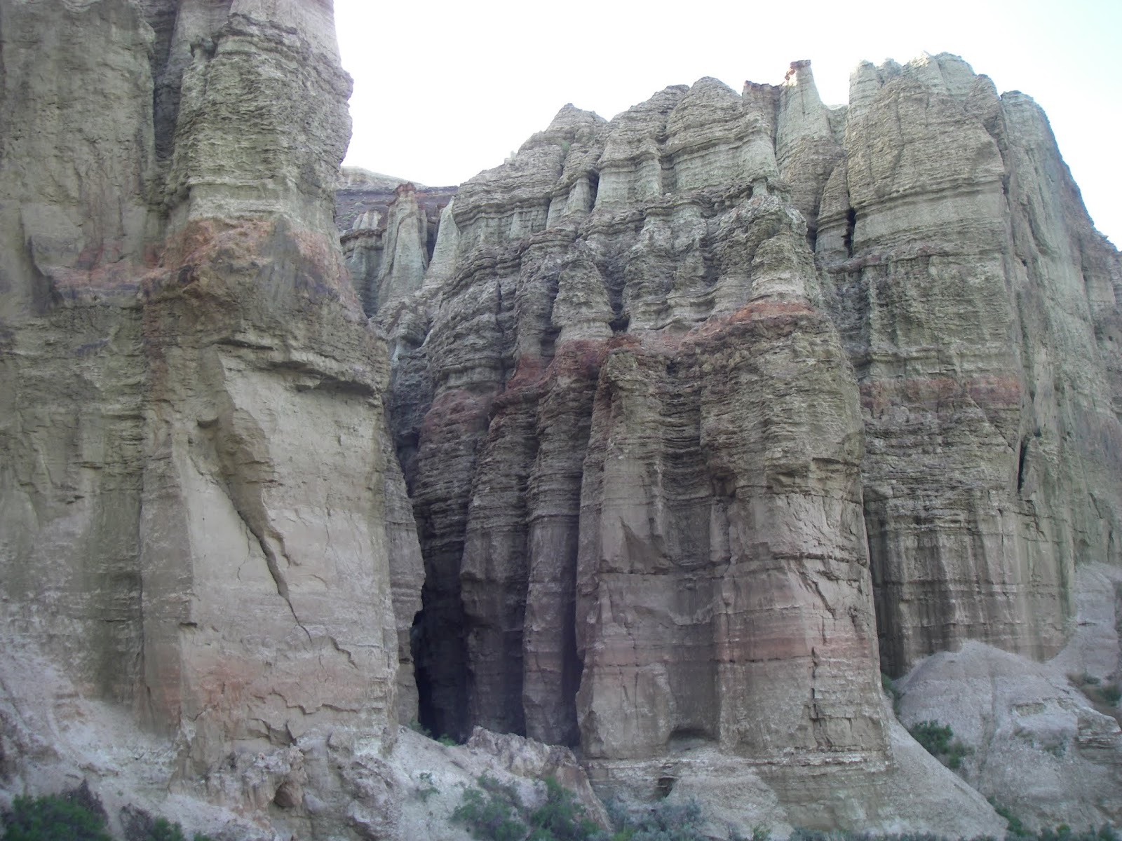
Cool nooks and crannies to explore.
If you go, make sure you have enough time to do some side-hiking. The area around Pruitt's Castle is a great place to hike, Hike-out camp is another sweet hiking spot early in the trip, and below Whistling Bird Rapids, there's a sweet campsite with a way to hike to the top of the rim and enjoy big views of the canyon. From that viewpoint, it's amazing how small you can feel, being a tiny little speck amid the giant Owyhee River Plateau.

All I can say is getting away on an Owyhee, Bruneau or Jarbidge-Bruneau trip is good medicine for the soul. And you know, right at that moment, that you're extremely fortunate to experience it.
------------------
A few notes on happenings this weekend:
  • Idaho Whitewater Association used equipment sale 9 a.m. to 3 p.m. on Saturday at Cascade River Gear.  
  • Sheep in the Foothills - A band of sheep is moving through the Boise Foothills as we speak for the next week or so. Watch the Life on the Range Facebook page or Ridge to Rivers Facebook page for sheep locations. 
The sheep were north of the Corrals Trailhead and Miller Gulch Trailhead on Wednesday, April 24.

- SS

Thursday, April 11, 2019

Go spring skiing on last weekend at Bogus, Brundage or try Wilson Creek in the Owyhees

Cottonwood Creek jumped out of its banks and washed out Rocky Canyon Road.
ACHD is working to restore the road before the Race to Robie Creek next Saturday. 
Hi all,

With all the incessant rainy weather we've been having in the Boise Valley and beyond, I've been thinking that, hey, I can always recommend Ol' Rocky Reliable - my term for Rocky Canyon Road - as a good alternative for hiking, trail-running and mountain biking when the foothills trails are wet and muddy.

That's what Wendy and I did last Sunday to take our dog Huck on a short walk. If we'd gone up the road 3.5 miles, we would have run into a major washout on Rocky Canyon Road. Take a look at the video above ... ACHD is in the midst of working to repair the road today (Thursday, April 11), and so they have closed Rocky Canyon Road to public use to allow heavy equipment operators and engineers restore the road. The road is closed until repairs are completed. No time estimated has been given as yet.

The Race to Robie Creek is coming up next Saturday, April 20, so all of the walkers and trail-runners are surely itching to continue training for the "toughest half-marathon in the Northwest." This year's theme is the "Birth of the Wonder Toad." It's always a hoot!

So anyway, I can't even recommend Ol' Rocky Reliable this week. Fortunately, the weather is supposed to dry out on Friday, and Saturday looks like the best day of the weekend for a little outdoor exploration. High temperatures are forecast in the low 60s in the Boise Valley and full sun is expected all day. Really? Sunday looks like rain and crapola.

So here are my recommendations:

Pond-skimming at Bogus Basin (Courtesy Bogus Basin) 
1. Enjoy the last weekend of operations at Bogus Basin or Brundage Mountain and go spring skiing. High temperatures are forecast to be in the mid-40s with sunshine at Bogus on Saturday, and 40 degrees at Brundage with partial sunshine. Bring your own BBQ if you want for a little tailgate action!

Bogus Basin is hosting a pond-skimming event from 1-4 p.m. on Saturday, and a Boxzilla event from 11:30 a.m. -12:30 p.m. on Saturday, a raffle for a Morning Star 2-person classic chair on Saturday, and a  PBR Ribbon Hunt until Sunday, along with live music from High Pine Whiskey Yell. Bogus closes for the season after the ski day on Sunday.   

Brundage has a Gelande Quaff beer-catching and drinking event on Saturday, and the Dodgy Mountain Men are playing live music that day. Brundage closes on Sunday at the end of the ski day at 4:30 p.m.

Both mountains have plenty of snow for AT and Tele skiers who will be climbing for their runs in the coming weeks.
Harrison Hollow all-weather trail is a great choice in inclement weather. 
2. Go hiking, trail-running or biking on Boise Foothills trails if they dry out. Refer to the Ridge to Rivers Facebook page for the latest conditions and recommendations. I went hiking in the Harrison Hollow area last night with Huck, and the high winds dried out the trails amazingly quickly. Please tread lightly and don't damage the trails. If mud is sticking to your shoes or your bike tires, please turn around.

As an alternative, here's my post from March that recommended a number of excellent destinations with all-weather trails, including Eagle Island State Park, Hyatt Hidden Lakes, Harrison Hollow,

3. Go hiking or biking in the Wilson Creek area in the Owyhees on Saturday. The weather looks best for doing the Wilson Creek-Reynolds Creek hiking loop on Saturday. The loop is 7.5 miles, starting from the Wilson Creek Road trailhead, south of Nampa, on the south side of the Snake River.

Here are directions and a description to the hike: You take ID 45 south of Nampa toward Murphy. Cross the Snake River, turn right and head for Marsing. Watch for Wilson Creek Road on the left. Take Wilson Creek Road to the BLM trailhead for Trail #300 on the left side of the road. Park. The hike starts here.

Follow Trail #300 over to a junction with a dirt road. Go left on Road #410 and follow that over to the China Ditch Trail #600 in Reynolds Creek canyon. This is the best part of the hike. Go upcanyon on Trail #600 and enjoy the redrock canyon of Reynolds Creek. Good place for lunch. When the canyon opens up, you'll see a junction with Trail #510, which heads back over to the junction with Trail #400. Take that trail back to the parking lot.

Reynolds Creek canyon is a gorgeous spot, no matter if you're hiking or biking. 
Robie Creek Runners would enjoy doing that loop as a trail-run, and for more elevation, they could do the Wilson Creek Mini-Moab route that I pioneered with my mountain bike years ago for the Mountain Biking in Idaho guidebook. That loop is 15.6 miles. It's detailed in my Owyhee Canyonlands guidebook as well. You basically start at the lower Wilson Creek Trailhead and follow the main Wilson Creek BLM dirt road 6.5 miles uphill to a left-hand turn on a primitive road to the top shoulder of Wilson Peak, about 2,000 feet of vertical from the start. You follow the rocky primitive road around the east side of Wilson Peak and drop down to a valley that intersects Trail #400 and Trail #300 returning to the Wilson Creek Trailhead.
- SS

Thursday, April 4, 2019

Go see thousands of snow geese at Ft. Boise WMA, pond-skimming at Brundage or biking


(Courtesy Idaho Department of Fish and Game)

Hi all,

It appears that we have a rainy weekend ahead, at least that's the forecast for Friday and Sunday. There's only a 20 percent chance of rain on Saturday, so there may be a few breaks in between storms or squalls where you can get out and do something fun outdoors!

I'm recommending three things for my outdoor tip of the week -- go to Fort Boise Wildlife Management Area (WMA) in Parma to see thousands of snow geese, go pond-skimming at Brundage Mountain or dash out on your bike between rain storms.

What a thrill to see the snow geese flying around in this giant wetland preserve and cottonwood forest where the Boise River meets the Snake River near the Idaho-Oregon border.

This is the same area where trappers stopped in to trade wares at Fort Boise. After 1835, they could stop and visit with post master Francois Payette, who was a very successful trapper (see historical chapter in my Paddling the Payette book) who arrived in Idaho and the Northwest in 1818 at the dawn of the trapping era. He also had a hand in mapping the region, hence, all of the rivers and lakes bearing his name.

But think of the rich fish and wildlife resource that existed there at the time -- salmon and steelhead, sturgeon, trout, all kinds of ducks, deer, moose and maybe even elk. Payette traded with many different Native American tribes, stole horses from them and vice-verse, and he took a few Native American women as his wives. Several Indian children emerged with the last name of Payette.

Here's a link to the Fort Boise WMA web page, which has directions to the refuge and an excellent list of birds you may see there.

Here's a brave lad giving it a go! (Courtesy Brundage Mountain)
McCall Realtor Lolo Nelson has won the
contest in the past wearing a prom dress.  
2. Go pond-skimming at Brundage Mountain. Brundage is poised to receive a batch of new snow on Saturday-Sunday (up to 9 inches are expected), and you could participate in the Crazy Daze pond-skimming competition on Saturday, starting at 1:15 p.m. There's also a beer relay, poker run, photo scavenger hunt and a costume contest.

Temperatures are forecast to freeze Friday night, with a low of 27 degrees, and there's new snow forecast Saturday, Saturday night and Sunday. Watch my Opensnow.com forecasts for the last details. 

Look for lodging deals in McCall by checking with the McCall Chamber or InIdaho.com. Maybe even Shore Lodge or the Holiday Inn Express?

3. Go for a bike ride in between the rain storms. I'm talking road biking because the Boise foothills trails will be wet after the rain we get this weekend.

  • Take a long ride on the Greenbelt and plan a stop at a favorite spot for coffee, lunch or a beer.  
  • Do the Cartwright 3 Summits Loop. 
  • Ride out to Eagle and back on Hill Road and Floating Feather. 
  • Ride to Hilltop Summit above Lucky Peak. Wendy and I did that last Saturday. We started at Municipal Park and rode to Hilltop and back, enjoying the new pavement that Ada County Parks and Waterways put in between IDPR headquarters and Diversion Dam. That ride is 27 miles round-trip, with 1,214 feet of elevation gain. 
  • Ride a loop somewhere close to your house so you don't get wet! Ha! 
  • Pick up a Boise Road Cycling Guide, a full-color waterproof map of the best road bike rides in the Treasure Valley.
All downhill from here! A bearded Steve at Hilltop Summit. 
Have fun! 
- SS 


Thursday, March 28, 2019

Spring has sprung in the Owyhees! Exploring Sage Creek is a low-key kid-friendly hike

A full-size pickup is dwarfed by the entrance to Sage Creek 
Interesting geologic mix in Sage Creek ... you'll see new quirky stuff around every bend in the canyon. 
Hi all,

The weather looks fabulous for this outdoor activities this weekend! With blue sky and high temperatures forecast in the high 50s to 60 degrees, it should be a perfect weekend to go hiking in the Owyhee Canyonlands.

This week, I'd like to feature a couple of cool hikes in the Owyhees in the Sage Creek area, near Succor Creek State Park. Sage Creek is featured in my guidebook, the Owyhee Canyonlands: An Outdoor Adventure Guide. It's a low-elevation destination, with tons of unusual and colorful volcanic rock and ash formations. It's a kid-friendly and family friendly hike.

"Sage Creek is a hidden jewel chock full of spectacular volcanic rock and ash formations in the creek-bottom and on the mountainsides as you hike along the creek," I wrote in the book. "One of the key highlights in Sage Creek is that you'll encounter multiple balanced rock features, some of them obvious phallic-type symbols, as well as spires, cliffs, fins and caves."
My son, Drew, loves hiking in the Owyhees. 
Our guide features a 2.5-mile exploration out-and-back hike, cruising up the bottom of Sage Creek (rated easy for all abilities), and a 6-mile hike up to the top of McIntyre Ridge from Sage Creek (rated moderate to strenuous), with nearly 2,000 feet of climbing. Both of them are great!

How to get thereTake I-84 to the ID 55 exit in Nampa, heading west toward Marsing. Go west on ID 55 and  and Turn right on Chicken Dinner Road, then left on Homedale Road, and go to Homedale. Follow State Highway 19 west of Homedale, and then Highway 201 in Oregon, to a signed turnoff for Succor Creek State Park on the left. Head south on the dirt road. It's 12.1 miles to the unsigned right-hand turnoff  for the Sage Creek Trailhead. There is a lone scrubby cottonwood tree at the turnoff. Follow the primitive two-track road over several creek-crossings to the trailhead .9 miles from the Succor Creek Road.   

Nice rhyolite cliffs with Wendy in the foreground. 
Road access challenge: 4WD high-clearance vehicle is required to reach the trailhead; multiple creek crossings are involved. It's possible, however, to take a 2WD vehicle to the Sage Creek road junction, and hike from there. Add .9 miles to the trip if you start from Succor Creek Road.

Hike #1 - 2.5-miles out and back
Cruise up the creek-bottom of Sage Creek, picking your way up the draw as you like. Hike at least a mile upstream to see the balanced rock features on the mountainsides above the draw as well as many other interesting rock formations. The volcanic ash flows in the area have turned different shades of white, orange and green over time. These formations are very erosive ... you can scratch the ash with your fingernails. Wear shoes that can get wet ... there might be some water in the creek-bottom, and you'll encounter some pools along the way. 

Hike #2 - 6-mile loop
From the end of the road, hike up-canyon and cross the creek to the left side. At mile .2, climb up the left-hand draw. It's a super-cool hike through many rock formations as you ascend the draw. It's about 2 miles to the top of the saddle near McIntyre Ridge. Climb to the top of McIntyre Ridge if you'd like. This area overlooks Succor Creek State Park to the east and Three Fingers Rock and many other features to the west. On the way down, descend the ridge to the left of the draw you climbed up, and enjoy a cool hike down into the draw. You'll pass by the "official" balanced rock on your way into the draw. Turn right at the bottom of the draw, and hike back to the trailhead.

Rhyolite balancing on top of ashflow tuff layer.
Camping notes: You could camp in the bottom of Sage Creek. Quiet spot. Self-support camping. You also could camp at Succor Creek State Park, which has a public rest room, very close by, but that will be much more crowded. If you'd like to explore some other areas, Succor Creek Road connects to Leslie Gulch, Three Fingers Rock and many other areas worth checking out in our guidebook. 

Have fun! 
-SS   

Thursday, March 21, 2019

Gotta plan ahead to visit The Springs in Idaho City! Stay overnight at Inn the Pines

The Springs pool at night (Courtesy The Springs)
The Springs during the day ... please note that the pool is reserved for adults on Wed-Fri each week. (Courtesy The Springs)

Hi all, 

It's a little exasperating how challenging it can be to book pool time at The Springs in Idaho City. I would readily admit that I don't necessarily like to plan ahead that much, but I have learned that if you want to book some pool time at The Springs, you MUST plan ahead! Two weeks or more! That's just the deal! 

Two friends of ours, Greg and Jan, booked a private pool for all four of us at The Springs last week (booked a month in advance), and we also booked rooms at Inn the Pines. We really enjoyed our time up there. 

The private pools are $45/hour, and hotel rooms are about $115/night. They have package deals. 

The snow is deep in Idaho City, too! But it's melting! Consider doing a hike in Charcoal Gulch before soaking. 

We went up on a Wednesday, so I had some work-related things to clear in the first half of the day. Then we got up to Idaho City in time to do a little boot hike on Charcoal Gulch Trail just outside of town before our leisurely soak at The Springs. The snow was brick-hard, so we didn't even need to deploy our snowshoes ... just cruised around on top of the snow in our snow boots. The trail is located next to the Idaho City airport on the south side of town ... try it sometime. 

Our private pool was booked for 4:30 p.m. We showed up at 4 p.m. to hang in the main pool before going into our private quarters. We had a beer and relaxed while the sun began to shine through the clouds for the first time in days. The Springs has pool-side service, so that's a plus in my book. They seem to really emphasize customer service, and that must be why The Springs has become so popular! 


The private pool was a perfect size for 2 or 4 people. It's a little cozy with 4, but if they're good friends or family, it works fine! You have total privacy in that space, so suits are optional. You can bring drinks and food into the private pools. But they will only serve you one drink while you're in the private pool FYI. 

The private tubs are warmer than the main pool ... I would guess they keep them in the 102-103 degree range. It felt just about perfect to us. 

After you've had your private pool session, you can hang in the main pool as long as you want. We were pretty pruned after about 2 hours of soaking, so we back to the Inn the Pines to change for dinner. The locker rooms at The Springs are very nice, BTW, they have complimentary lockers that come with your swimming pass, and nice showers. 


We thought the rooms at Inn the Pines were really nice. The hotel was just built a year ago or so, so everything seems almost brand new. They have cable TV and wifi in the rooms, even though there is barely any cell service in Idaho City, so that's another plus. I had some work-related things I had to send out by email in the morning. That worked without a hitch.  

We had dinner and breakfast at Trudy's Kitchen. We should have had dinner at the Gold Mine or Diamond Lil's, most likely, because they specialize in serving dinner. But Trudy's makes good burgers and has good breakfast. Here's the Trip Advisor rundown for Idaho City restaurants. 

All in all, we heartily recommend soaking at The Springs and staying at Inn the Pines. All you have to do is plan ahead!!! Combining the soaking experience with a fun day of skiing by Mores Creek Summit or at the Idaho City Park and Ski Areas would be the ultimate home run day, in my book. 

In the weeks ahead, it also would be a fun home run day to do the Banks-Lowman drive to see elk down by the road and Payette River, and then hit the Springs in Idaho City late in the afternoon. Stay overnight and relax! 

If you want to soak at The Springs, go online and reserve a time for your group. The reservations system lets you see what's available on a given day online. Pick what works for you! 

-----------------------

On another subject matter, during Spring Break week the lower trails in the Boise Foothills dried out and people were out using the trails in droves! Huge numbers of cars at the trailheads! Just wanted to remind folks to be aware that the the trails could get muddy this weekend if we get substantial amounts of rain. Please pay attention to the Ridge to Rivers web site or Facebook page for the latest updates! 

- SS 

Thursday, March 14, 2019

Eight outdoorsy ideas for Spring Break ... fantastic weather coming our way!

These guys know how to do the Spring Skiing thing ... Courtesy Opensnow.com 
Hi all,

The weather looks absolutely fabulous this coming weekend and next week in the greater Boise area ... perfect for Spring Break! Especially for those who may be staying close to home.

Here are 8 outdoorsy ideas to keep you occupied and entertained during Spring Break:

1. Spring skiing should be great at BogusBrundageTamarack and Sun Valley. Be sure to wait till it warms up a bit during the day, and then go ski some corn snow. The afternoons look fantastic for skiing in the coming week, with temperatures in the high 30s and 40s for spring snow, sunshine and apres ski parties on the deck. See my daily snow forecasts on opensnow.com.

2. Take a ski vacation to Grand Targhee, Jackson Hole or AltaSolitude or Snow Basin in Utah. All of the recent snow should make for excellent conditions at any of those areas. Use the free days on your season passes at partnering resorts.

3. Do a home run weekend in the Magic Valley - Go see Shoshone Falls (water flows should last through May), have a top-shelf dinner at Elevation 486, ski Pomerelle and then hit Miracle Hot Springs on your way home and top it off with dinner at the Snake River Grill in Hagerman.

Hiking or camping at Leslie Gulch should be fab. Huck likes the view. 
4. Go camping in the Snake River Canyon or in the Owyhees, close to home. Here are five destinations that are sure to please, including Succor Creek State Park, Leslie Gulch, Bruneau Dunes State Park, and Celebration Park.

5. Boise Foothills trails are starting to dry out but tread lightly! Check the Ridge to Rivers Facebook page for the latest conditions and recommendations. My book, Boise Trail Guide: 95 Hiking and Running Routes Close to Home provides lots of ideas on where to go ... 

Bruneau Canyon! (Courtesy Visit Idaho) 
6. Go see the Bruneau River canyon or double-up and visit the Bruneau Dunes on the way there or the way home.

7. Dust off the road bike and go for a ride. Here are seven rides to try in Boise for various ability levels. All of the rides are from my Boise Road Cycling Guide, the only guide to road biking in the Boise area.

8. Take a hike in the Owyhees. One of my favorites is the Wilson-Reynolds Creek Loop, which includes touring the beautiful redrock Reynolds Creek canyon and hiking the China Ditch Trail. See my Owyhee Canyonlands book for 55 hikes and bike rides in the Big Wide Open.

Have a wonderful Spring Break!
- SS

Thursday, March 7, 2019

Shoshone Falls is coming to life! Spring is the ideal time to tour Magic Valley waterfalls

Shoshone Falls last weekend as the flows were beginning to come up. (Courtesy Southern Idaho Tourism) 

Looking downstream of Shoshone Falls into the yawning Snake River Canyon. 
Hi all,

Thanks to the bountiful precipitation we received in February, the mountain snowpack situation in
Idaho is totally positive, if not a bit over the top in places (are we tired of back-breaking snow-shoveling yet???). All of the snow ensures that we're going to have a big river runoff season this spring in every river basin statewide!

The Snake River is no exception, with 115-125 percent of normal snowpack at the moment in the Upper Snake region. The Bureau of Reclamation is beginning to release flood-control flows below Milner Dam in the mid-Snake region, bringing mighty Shoshone Falls to life.

Today, about 6,000 cfs were passing over the 212-foot falls, the Niagara of the West. That makes for a breath-taking view!

Road trip anyone? Shoshone Falls Park is open for daytime viewing. I'd recommend going to see the impressive falls as a fun day trip or overnight, weekend trip. Maybe hit a hot springs along the way, go to the Twin Falls Sandwich Company for lunch, or select from this Trip Advisor menu of top local lunch and dinner spots.

Check out this drone video of Shoshone Falls from Reeder Flying Service shot in February 2017 when all of the low-elevation snow came off and flooded the region. This is why you should go!


Remember that there are a number of other waterfalls to experience while you're in the neighborhood. See a local guide for details.

Did you like seeing all the bald eagles roosting in a tree near Wendell this week? Here's how to get there ... Read this post: https://visitsouthidaho.com/winter-weather-draws-big-numbers-bald-eagles-waterfowl-wendell-hagerman-area-go-see/

If this weekend doesn't work for Shoshone Falls, know that flood-control flows will be coming over the falls for the next couple of months through May, according to the BOR. You can see what they're releasing online at any time (check cfs by Milner Dam). I'd guess that it's going to run strong for the next 8-10 weeks, given the deep snowpack. I'm just guessing ... no guarantees.

Upper Snake teacup shows reservoir contents and outflow (click to enlarge) 
On your way to the Magic Valley, I recommend taking the Thousand Springs Scenic Byway from Hagerman to Buhl and Twin Falls. You can go fishing in that area by Hagerman WMA, stop at one of three hot springs, or visit the Minnie Miller springs and other units of Thousand Springs State Park.  

Also, the Middle Snake is known for kick-ass whitewater boating and some sweet flatwater paddling as well. Contact Idaho Guide Service if you'd like to run the Class 4+ Murtaugh reach of the Snake River during the spring flows. Think big rapids, big roaring whitewater. After the river flows calm down, you can paddle from Centennial Park in Twin Falls up to the brink of Shoshone Falls in the deep Snake River canyon while maybe seeing a base-jumper parachute overhead while passing underneath the giant Perrine Bridge.

Stop in the Visitor Center in Twin Falls on the south side of the Perrine Bridge for information about what to see and do in the region. It's a beautiful building next to the canyon.
-----------------------------
Notes: There's a Scoop the Poop event on Saturday, sponsored by the City of Boise. Click on the event page for more information. Dog owners are encouraged to go out and scoop up poop next to our foothills trails from 9 a.m. to noon on Saturday. Please do your part!

-SS