Showing posts with label canyons. Show all posts

Thursday, March 28, 2019

Spring has sprung in the Owyhees! Exploring Sage Creek is a low-key kid-friendly hike

A full-size pickup is dwarfed by the entrance to Sage Creek 
Interesting geologic mix in Sage Creek ... you'll see new quirky stuff around every bend in the canyon. 
Hi all,

The weather looks fabulous for this outdoor activities this weekend! With blue sky and high temperatures forecast in the high 50s to 60 degrees, it should be a perfect weekend to go hiking in the Owyhee Canyonlands.

This week, I'd like to feature a couple of cool hikes in the Owyhees in the Sage Creek area, near Succor Creek State Park. Sage Creek is featured in my guidebook, the Owyhee Canyonlands: An Outdoor Adventure Guide. It's a low-elevation destination, with tons of unusual and colorful volcanic rock and ash formations. It's a kid-friendly and family friendly hike.

"Sage Creek is a hidden jewel chock full of spectacular volcanic rock and ash formations in the creek-bottom and on the mountainsides as you hike along the creek," I wrote in the book. "One of the key highlights in Sage Creek is that you'll encounter multiple balanced rock features, some of them obvious phallic-type symbols, as well as spires, cliffs, fins and caves."
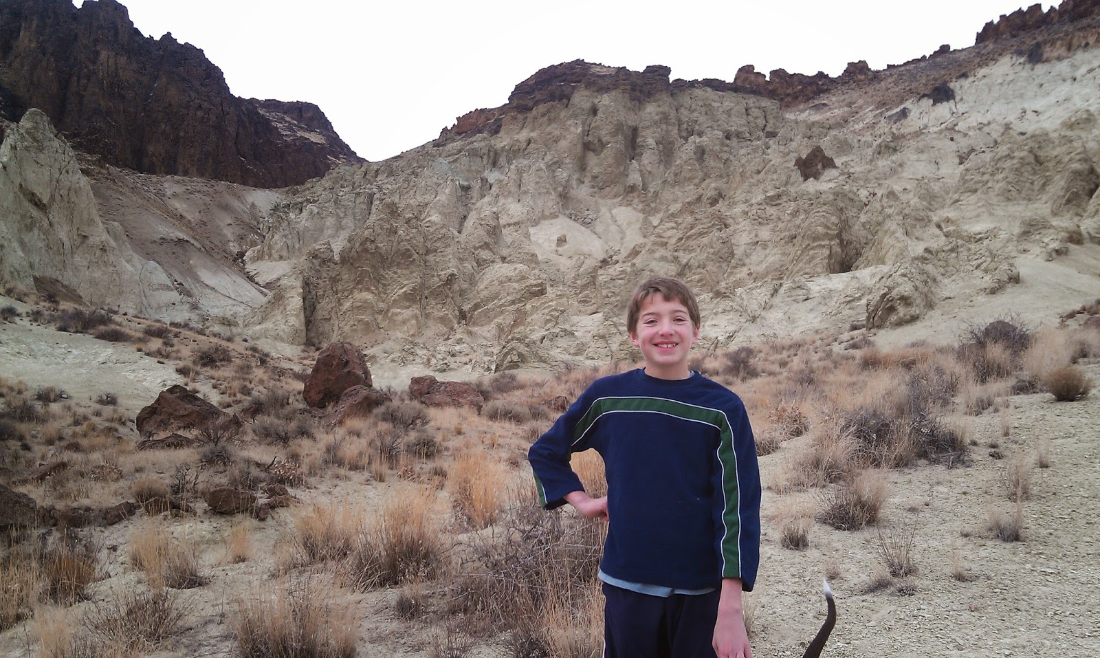
My son, Drew, loves hiking in the Owyhees. 
Our guide features a 2.5-mile exploration out-and-back hike, cruising up the bottom of Sage Creek (rated easy for all abilities), and a 6-mile hike up to the top of McIntyre Ridge from Sage Creek (rated moderate to strenuous), with nearly 2,000 feet of climbing. Both of them are great!

How to get thereTake I-84 to the ID 55 exit in Nampa, heading west toward Marsing. Go west on ID 55 and  and Turn right on Chicken Dinner Road, then left on Homedale Road, and go to Homedale. Follow State Highway 19 west of Homedale, and then Highway 201 in Oregon, to a signed turnoff for Succor Creek State Park on the left. Head south on the dirt road. It's 12.1 miles to the unsigned right-hand turnoff  for the Sage Creek Trailhead. There is a lone scrubby cottonwood tree at the turnoff. Follow the primitive two-track road over several creek-crossings to the trailhead .9 miles from the Succor Creek Road.   

Nice rhyolite cliffs with Wendy in the foreground. 
Road access challenge: 4WD high-clearance vehicle is required to reach the trailhead; multiple creek crossings are involved. It's possible, however, to take a 2WD vehicle to the Sage Creek road junction, and hike from there. Add .9 miles to the trip if you start from Succor Creek Road.

Hike #1 - 2.5-miles out and back
Cruise up the creek-bottom of Sage Creek, picking your way up the draw as you like. Hike at least a mile upstream to see the balanced rock features on the mountainsides above the draw as well as many other interesting rock formations. The volcanic ash flows in the area have turned different shades of white, orange and green over time. These formations are very erosive ... you can scratch the ash with your fingernails. Wear shoes that can get wet ... there might be some water in the creek-bottom, and you'll encounter some pools along the way. 

Hike #2 - 6-mile loop
From the end of the road, hike up-canyon and cross the creek to the left side. At mile .2, climb up the left-hand draw. It's a super-cool hike through many rock formations as you ascend the draw. It's about 2 miles to the top of the saddle near McIntyre Ridge. Climb to the top of McIntyre Ridge if you'd like. This area overlooks Succor Creek State Park to the east and Three Fingers Rock and many other features to the west. On the way down, descend the ridge to the left of the draw you climbed up, and enjoy a cool hike down into the draw. You'll pass by the "official" balanced rock on your way into the draw. Turn right at the bottom of the draw, and hike back to the trailhead.

Rhyolite balancing on top of ashflow tuff layer.
Camping notes: You could camp in the bottom of Sage Creek. Quiet spot. Self-support camping. You also could camp at Succor Creek State Park, which has a public rest room, very close by, but that will be much more crowded. If you'd like to explore some other areas, Succor Creek Road connects to Leslie Gulch, Three Fingers Rock and many other areas worth checking out in our guidebook. 

Have fun! 
-SS   

Thursday, November 17, 2016

Try Death Valley as a winter destination to explore unique canyons, dunes and peaks

Mosaic Canyon ... getting into the marble zone 
Red Pass is down where our white pickup truck rental is parked.
On our way to Thimble Peak. 
Thimble Peak 
On the summit. We got out early and beat the heat. 
Titus Canyon 
Hi all,

I took Wendy to Death Valley National Park recently for a quick 4-day getaway, and I was impressed. I'd never been there before. I had heard that it's a great winter destination -- the ideal time to visit a place that has temperatures in the 130s in mid-summer. In early November, we experienced lows in the 60s and highs in the 80s in the afternoons. It's even cooler in December and January.

We stayed at the Furnace Creek Ranch for about $150/night. We liked that spot quite a bit. There's a large swimming pool for ranch guests to use, plus tennis courts and a bacce ball court. Wifi was kind of lame, but you're supposed to be on vacation. There are three restaurants and a general store in Furnace Creek where you can find suitable eats and supplies. There also are many different campgrounds in the national park where you could park an RV or tent camp.

Here are a few places that I'd recommend visiting:

  • Mosaic Canyon - There are some neat rock formations in Mosaic Canyon -- really old limestone rock that dates to 700 million years old is overlain by much more recent compacted sediment and gravel that occurred just several thousand years ago. The old limestone rock eventually changed to dolomite and then marble over the years. About 1 mile up Mosaic Canyon, you get into the smooth marble rock in the canyon walls, and the canyon narrows as you hike upstream. Continue up the canyon, the views and geology keep getting better. 
    Golden Canyon above the valley floor 
  • Golden Canyon - We really liked Golden Canyon. It's close to Furnace Creek, and it's a beautiful hike into Golden Canyon in the morning or evening when the low-elevation light punctuates the topography. The geology in the Golden Canyon area is more fine silt, sand and ash-flow tuff layers from volcanic eruptions. It's a mixture of beige, tan and much older rocks above the silt and tuff layers. You can do an out-and-back hike in Golden Canyon, climb to Zabriskie Point or do a 5-mile loop with a vehicle shuttle. 
    View from Zabriskie Point as the sun was going down 
  • Zabriski Point - This is a super-cool point of interest off the main highway leading into Furnace Creek. It's a very short walk to a gorgeous overlook of the Golden Canyon area. If you go there at sunrise or sunset, the colors are spectacular. We got there near sunset and took a lot of pictures as the sun went down. 
    Loved the twilight from Zabriskie Point 
  • Badwater Salt Flats - Given that this is the lowest point in North America (282 feet below sea level), it's worth visiting Badwater Basin just to say you've been there. It's a salt flat with a trail that goes out into Badwater Basin in the middle of Death Valley. Perfect for a selfie photo. 
    Badwater Salt Flats 
  • Mesquite Flats Sand Dunes - The dunes near Stovepipe Wells Village are quite extensive, a larger dune complex than Bruneau Dunes State Park. We didn't explore the dunes but they looked like fun to explore when the temperatures are moderate. 
  • Titus Canyon - Thanks to some friends, we got a cool tip to go climb Thimble Peak off of Red Pass as part of doing a big driving loop. The canyon is so tight that the whole route is one-way. We drove the Daylight Pass road from Death Valley into Nevada (about 30 minutes), and then drove a dirt road up to Red Pass to start our day hike to Thimble Peak. We climbed up a ridge to a shorter mountain (6,100 feet elevation) and then scaled Thimble Peak (6,500 feet). The 360-degree view was totally spectacular up there. We climbed back to our rental pickup truck, and then drove down Titus Canyon back to Death Valley. You go through an old mining area on the narrow two-track road. Glad we had a high clearance rig! Highly recommend doing that drive and then taking some side-hikes along the way. 
There are many other canyons and peaks to explore in Death Valley. This was just our first trip. But I'd recommend visiting the area in the winter and enjoy a vastly different experience than other canyons and peaks in the West.

FYI - We took a direct flight from Boise to Vegas on Southwest Airlines, rented the pickup truck from Enterprise Rental, and were in Death Valley by around noon. Very easy to get there from Boise, we thought. Many people drive down in their camping rigs so they can camp out and enjoy the area in that fashion. I've heard that when it gets windy down there, camping isn't much fun because of the blowing sand. 
-SS