 |
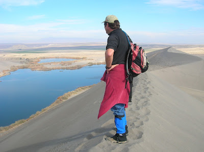
| Steve on top of the dunes. Wearing boots and gators to keep sand out of shoes. |
 |
| Big Jacks Creek photographed from the Parker Trail |
 |
| Bruneau Canyon upriver |
 |
| Bruneau River Canyon from the Overlook (courtesy VisitIdaho.org) |
The weekend weather promises to be partly cloudy and relatively cool, with highs in the low 70s -- perfect for hiking in the Owyhees. Last week, I recommended Wildcat Canyon near Marsing. This week, I'm recommending three outings in the Owyhees near Bruneau, south of Mountain Home.
I'm recommending Bruneau Dunes State Park, the Bruneau Canyon overlook, and Big Jack's Creek, the Parker Trail. All of these destinations are knock-your-socks-off scenic with fun exploring opportunities and optional camping. All of these destinations are detailed in my guide, Owyhee Canyonlands: An Outdoor Adventure Guide,. which features 55 hikes and bike rides in the vast, 5-million-acre area south of the Treasure Valley.
So let's get to it!
- Bruneau Dunes State Park - Go visit North America's tallest single-structured dune, 470 feet high. It's easy to climb up there and cross the top sandy ridgeline of the dune, and check out the other smaller dunes in the area. There's also some fishing there at the park, and the camping at Bruneau Dunes is absolutely first-class with services. Distance: 3 mile loop. Travel time: 1-2 hours at a very leisurely pace. Bring the kids! Great place for them to play. Pack a lunch. Bring plenty of food and water. Trail map here. Buy a $10 state parks pass with your vehicle registration so you can get free entry into any of Idaho's state parks year-round. Awesome deal! How to get there: Take I-84 to Mountain Home. Take the first exit and go south on Idaho 51 towards Bruneau. Cross the Snake River and then turn left and follow signs to the park.
- Bruneau Canyon Overlook - This is another family friendly adventure to go see the yawning Bruneau River Canyon, 18 miles south of the town of Bruneau. The canyon is 800 feet deep from the top of the rim down to the rushing river. It's super cool to check out the layer-cake like geology of the canyon. Multiple layers of volcanic basalt and rhyolite are exposed in the canyon. If you don't have a copy of "Roadside Geology of Idaho," I heartily recommend it. How to get there: Take I-84 to Mountain Home. Take the first exit and go south on Idaho 51 to Bruneau. Pick up any last-minute items at the market in town, then turn left on Hot Springs Road and follow that south of town. After 8.5 miles, go left on the Clover Creek-Three Creek Road, a good-quality gravel road. 15 miles south of Bruneau, you'll see a BLM sign on the right, indicating the turn for the overlook. You could self-support camp in that area. You also could hike or bike on the two-tracks next to the overlook.
- Big Jack's Creek, Parker Trail - Distance: 2.5 miles; rated moderate to strenuous. Travel time: 2 hours or more. Pack a lunch and make a day out of it! Big Jacks Creek is a
gorgeous, vertical redrock canyon, carved out of rhyolite lava. The Parker Trail is a rare
developed trail anywhere in the Owyhee Canyonlands where a person can follow a
trail tread from the canyon rim to the creek-bottom. It's about 1.25 miles down
to the bottom. You'll come to a nice rock outcropping 1 mile down the trail, a
nice spot for a photograph. There's a sweet campsite at the bottom of the trail
next to Big Jacks Creek. So this trip has backpacking and camping potential.
How to get there: From Boise, take I-84 east to Mountain Home. Take the first exit. Follow signs for Idaho State Highway 51 and Bruneau. After you reach Bruneau, take note of your odometer. Stay on Idaho 51, going south, for approximately 27 miles. You'll be watching for a right-hand turn on a good dirt road, called the Wickahoney Road, just past milepost 45. The road is not signed, but it's a BLM public road. Follow the Wickahoney Road 4.9 miles to a T-junction by Wickahoney Creek. Turn right and go 2.8 miles to the Parker Trailhead. The road is rougher for the last 2.8 miles. Higher-clearance AWD recommended.
-SS


