Thursday, April 28, 2011

Ten hikes & bike rides suitable for families and kids for Be Outside and Unplug Week

Geoff Baker and his son, Morgan, on the Castle Rock Trail.

Dry Creek is a wet shoes kind of hike or bike ride, but it's really cool.

Kids love the pump track at the Eagle Cycle Park.

My son Quinn when he was much younger near Hulls Gulch

Steve enjoys the view on top of the Bruneau Sand Dunes
Hi all,

In the spirit of Unplug and Be Outside Week, I thought I'd recommend 10 hikes and mountain bike rides close to home that are perfectly suited for families and kids.

I took my 7th grader, Quinn, on a bike ride yesterday in Military Reserve. He's kind of a super jock, so he's been spending a lot of time playing hockey, skiing and playing baseball in recent weeks. Yesterday was a rare day when he didn't have baseball practice or a game, so I seized the day to take him on a ride on a gloriously sunny afternoon.

We rode the Jumpin' Jeepers Figure 8 Loop, a 6.5-mile hike or bike ride that culminates in climbing to Shane's Summit (see description below). Quinn had a funny low-speed crash on a tight corner. Check out the video.

He was complaining a bit about climbing Shane's until he saw a couple of young boys and girls at Shane's Summit from the Boise BYRDS, a youth-development cycling team. Some of the kids were less than 10 years old, and they made it up there! Plus, one of Quinn's classmates at North Junior High was there with the BYRDS. He was impressed.

All of the routes I'm recommending are featured in the Boise Trail Guide: 75 Hiking & Running Routes Close to Home and Mountain Biking in Boise, 5th edition. Most of these routes are pretty easy, but I tossed in a couple that are a little more challenging as well.

Be sure to bring plenty of food and water with you in a day pack. Pack a camera and take some pics. Take your time, and ask your kids how they're doing frequently to make sure they're having a good time. It's important that they have a good time, so they'll want to go on the next adventure.

In the spirit of the "unplugged" nature of this week, the tunes and cell phones should be left at home or in the vehicle. Blame it on me.

Here we go:

1. Veterans Park - Garden City Loop. This is a 3.25-mile Greenbelt loop. Good for hiking or biking. Hiking time is 1+ hour. Biking time is about 30 minutes. Start at Veterans Park in NW Boise at the corner of Veterans Parkway and State Street. The loop goes from the Veterans Memorial Parkway bridge to the Main Street bridge by the Double Tree Riverside and back. Check out the new pedestrian bridge along the way, and you can figure-8 the loop by crossing the bridge in each direction. If you've got really young kids, do the Veterans Pond loop (1 mile total). Here's some helmet cam footage of this loop.

2. Eagle Cycle Park. Go out West State Street to old Horseshoe Bend Road by the Stinker Station. Turn right and proceed 1.5 miles to the cycle park on the right. Here, you can set the kids loose on bikes and let them fool around on the pump track and small jumps. You also can cruise around on the easy but twisty singletrack trails next to the jumping area. The trails include Rabbit Run, D's Chaos, Twisted Sister and Junk Yard. All of the trails are short loops, so just cruise around until you or your kids get tired. The trails at the cycle park are open to hiking, running and biking. Here is my favorite video of the Eagle Cycle Park.

3. Owl's Roost-Redtail Loop. This is an easy 2.2-mile loop in the Central Foothills, starting and finishing from Camelsback Park (13th and Heron) in Boise. You can hike or bike the loop. Start from behind the tennis courts in the east side of the park. Go north on Red Fox Trail, cross 8th Street, and come back on Owl's Roost. You'll find Owl's Roost next to the Foothills Learning Center.

4. Seaman's Gulch Loops. This is a sweet and easy loop off of Seaman's Gulch Road in NW Boise. On the way to the landfill, you'll see a trailhead, rest room and parking area on the right next to a large brown water tank. There are two short loop hikes you can do here. The loop on Trail #110 is one mile, and the loop on Valley View Trail #111 is three miles. I recommend Valley View -- it has a great bird's eye view of the city up on the hill.

5. Military Reserve Double Ridge Loop. Go to the Fort Boise ballfields in NE Boise near St. Luke's Regional Medical Center. Take Reserve Street north from Fort Street, and turn left on Mountain Cove Road. Follow the road for over a mile around a corner and park at the trailhead. The Double Ridge Loop is 3.7 miles long. Take Central Ridge Trail #22 and climb up on the middle ridge in Military Reserve Park for a mile or so. At the top of the ridge, turn right on Ridge Crest Trail #20A and go downhill to Cottonwood Creek. Go left at the bottom of the hill, cross the creek, and go left on Eagle Ridge Trail #25. Follow that trail to the toe of the ridge, and drop down to the trails by the flood control cells next to Reserve Street. Turn right and hike/bike back to the trailhead. If you want to shorten this route for young kids, do a short loop on the Toll Road Trail #27A and Cottonwood Creek Trail #27 (total distance is slightly over 1 mile).

6. Jumpin' Jeepers Figure 8 Loop. This is a 6.75-mile moderate to strenuous loop in Military Reserve Park that's more suited for young teen-agers and up. Start at the same Military Reserve Trailhead (see directions on #5 above). Take Mountain Cove Trail along Freestone Creek out to the police firing range. Turn right on Trail #20 and climb to the left-hand turnoff for Buck Tail Trail #20A. Enjoy the twists and turns in Buck Tail and climb to Shane's Junction (Trail #26A). Climb to Shane's Summit. Now it's all downhill on the way back. Complete Shane's Loop, then take Central Ridge Trail #22 all the way back to the Trailhead. It took Quinn and I a little under 2 hours to ride this loop, including a few short stops.

7. Castle Rock - Table Rock Loop. This hike is called "Foothills on the Rocks" in my guidebooks. It's best done on foot because the trails are quite steep in a few places, especially in the approach to Table Rock on the south face. Trip distance is 4.35 miles. Travel time is 1.5-2 hours. Take Warm Springs Avenue east to the Old Penitentiary. Park behind the Bishop's House at the public trailhead. Take Castle Rock Trail #19 to the top of Castle Rock. If you have small kids, this can be your destination and loop back to the trailhead. Otherwise, take Trail #15 from the top of Castle Rock and climb to the top of Table Rock. Enjoy the view. Do a loop of Table Rock on Trails #16 and #17 and then retrace your steps back to the trailhead.

8. Surprise Valley - Oregon Trail Loop. I wrote about this earlier this spring as a great early-season route. Check out my blog for details on this route. It's 2.6 miles and 1 hour hiking time. Rated easy. It's great to do this one on a bike or on foot.

9. Dry Creek out and back. Ironically, Dry Creek is the only perennial stream in the Boise Foothills, even though the name would suggest otherwise. This is a good out-and-back trail. It's more than six miles to the top of the trail, but most people go just a few miles up and back. To find the trail, go about three miles past the stop sign at Bogus Basin Road and Curling Drive and park in an unsigned pullout on the right side of the road. This is an intermediate hike best suited for 8-year-olds and up. It's an advanced mountain bike ride. Be aware there will be several stream crossings, so your feet may get wet, especially this time of year.

10. Bruneau Dunes State Park. I had to toss this in as an option because kids love to play in the sand, and spring is a perfect time to visit the park. Take I-84 to Mountain Home. Go south on ID 51 toward Bruneau. After you cross the Snake River, turn left on ID 78 and follow signs to the park. There is overnight camping and RV hookups. Drive into the park to the closest access point to the dunes next to the lakes. Look for interesting animal tracks in the sand. See if your kids can identify the tracks. Climb to the top of the sand dune and enjoy the view.

For more detailed information and site-specific maps of these trails, go to www.stevestuebner.com.

For a large-scale Ridge to Rivers map of the Boise Foothills, click here.

-- SS

Steve shares his weekly outdoor tips with Ken and Tim on 94.9 FM The River each Friday morning at approximately 7:10 a.m. If you miss the program, you can hear the segments on River Interactive.com.

Wednesday, April 20, 2011

Try Hells Canyon for springtime hiking, backpacking, camping and sight-seeing

Denise Lauerman (all photos provided by Denise)

Peggy Jordan
The Snake River in Hells Canyon
Kirkwood Museum

A few creek crossings are required ...
A snail. Denise said she saw lots of them.

Elk!
The trail on the Idaho side

Overview map (click to enlarge)


L-R, Teri Stiburek, Peggy Jordan, Denise Lauerman at Lower Pittsburg Landing
Hi all,

It's been a long winter. A lot of people have cabin fever. We're all eager to get outside and enjoy some spring activities. The only problem is, the weather doesn't want to dry out. We're lucky to get even two days of nice weather in a row in SW Idaho and then it rains again.

People in Seattle would probably say "get over it!" Put on your rain gear and go.

Well, another possibility is to go hiking, backpacking and camping in Hells Canyon. A friend of mine, Denise Lauerman, and two of her friends backpacked 6 miles from Lower Pittsburg Landing to the Kirkwood Historic Ranch recently, and came home with lots of great photos. Many thanks to Denise and her friends, Teri Stiburek and Peggy Jordan, for sharing their pix.

"It was a great trip -- I can't wait to go back," Denise said.

Hells Canyon, the deepest gorge in North America at over 7,000 feet, stradles the Idaho-Oregon border for more than 100 miles. The mighty Snake River flows through the heart of Hells Canyon and continues on to Lewiston. Hells Canyon is usually the warmest spot in Idaho, and it's also drier than many areas, so it's a good bet for a spring trip. Ditto in the fall. In the middle of the summer, it gets sizzling hot; hence, the name.

I've written about floating through Hells Canyon, certainly the cushiest way to visit the area, but not everyone has all of the whitewater gear. So hiking, backpacking and camping are universal activities that anyone can enjoy there.

The trip starts with a 4.5-hour drive from Boise to Pittsburg Landing, the trailhead, via ID 55 to New Meadows, U.S. 95 to Whitebird, and then a well-maintained gravel road from Whitebird over Pittsburg Saddle to the trailhead at Lower Pittsburg Landing. Signs will guide you the whole way from Whitebird. Four-wheel-drive is not required to get there.

It's 6 miles from the trailhead to Kirkwood Ranch. Denise and her friends drove in on a Friday, backpacked to Kirkwood in the afternoon (allow 2.5-3 hours travel time) and base-camped on the grass next to the Kirkwood Museum, where former Idaho Gov. Len B. Jordan and his wife, Grace, ran a sheep ranch in the 1930s.

The museum is definitely worth visiting. Behind the ranch, there is a two-track gravel road that climbs Kirkwood Creek for more than 3,000 feet to a high saddle. This is a great side-hiking opportunity that Denise and her friends climbed on Day 2, seeing all kinds of cool wildlife and landscapes along the way.

On Day 3, they side-hiked to Suicide Point along the Snake River, came back to Kirkwood, strapped on their backpacks, and hiked out. Suicide Point provides great views of the river canyon.

The cool thing about Hells Canyon is that it has many sloping ridge lines that climb up to the mountains above. I have side-hiked many of them over the years, sometimes chasing chukars. The big benefit is that you get to see how the landscape changes in Hells Canyon -- from the dry environment with cactus, poison ivy, rattlesnakes and hackberry trees down by the river to much wetter environments higher up, eventually giving way to a forest environment, rocky peaks and high mountain lakes.

I don't mean to scare people but you should watch out for snakes, depending on how hot it is when you go. I've almost stepped on rattlers bird hunting along the river in the late fall, so they do hang out in the rocky talus slopes and basalt rocks.

One of the highlights of Denise's trip was that they had a bobcat in camp. "On the second night, it was outside our tent. Some other people heard it and saw it." The caretaker at Kirkwood Ranch saw the critter, and another party camping there had a dog, so it knew something was up. Guess Denise and her friends were tired enough from their hiking activity that they slept well.

To see Denise's full reel of photos on Facebook, here's the link.

For more information, go to the Hells Canyon National Recreation Area web site. You can purchase maps at the Hells Canyon NRA office in Riggins.

Enjoy!
- SS

Steve shares his weekly outdoor tips with Ken and Tim on 94.9 FM The River each Friday morning at approximately 7:10 a.m. If you miss the program, you can hear the segments on River Interactive.com.

Thursday, April 14, 2011

It's official: Boise Foothills trails are ready to enjoy

Google Earth GPS route of Cross-Foothills Route; click to enlarge
Hi all,

I checked on the Ridge to Rivers web site earlier this week to check on Boise Foothills trail conditions, and the headline was, "Trails are mostly dry." After all the rain in the last month, that's great news! We've got the official green light to go hiking, running or biking on foothills trails.

So I dashed out for a mountain bike ride on Tuesday afternoon, and indeed, the trails were bone dry. I went on a cross-foothills ride today (more on that in a moment), and the trails were mostly dry. Of course, as the Ridge to Rivers trail report points out, conditions can change when rain is in the forecast. There's a 50 percent chance of rain on Saturday, for instance. Be sure to give the trails a chance to dry out after a storm.

In the meantime, seize the day and head out on the trails. You'll hear the sound of meadowlarks, and the creeks roaring with snowmelt. Red-tailed hawks are soaring in the fresh winds, searching for prey. Foothills grasses are turning green and shrubs beginning to bloom. Spring is in the air!

It's always interesting to see how the legs and lungs have fared over the winter during the ski season. If you're like me, you've got some lung power, but the quads aren't that used to climbing long steeps. Winter road biking helps. But you've pretty much got to go mountain biking for real to get in mountain biking shape. Same goes for hiking and running.

So if you haven't been training for the Race to Robie Creek (the race is Saturday!) for the last month, take it easy at the beginning of the season and tackle some easier hikes, runs and bike rides to get the body tuned up for the summer.

I've got some recommendations from Mountain Biking in Boise and Boise Trail Guide. The main thing right now is to focus on the mid- to lower foothills trails. The upper trails and the Boise Ridge Road are still snow-bound. The trails in the mid- to upper foothills, such as the Watchman Trail, are still wet and greasy in some places, so it's best to wait for them to dry in the coming weeks.

  • Cross-Foothills Ride (Intermediate; strenuous in places) - 10 miles. 2 hours riding time. Today, I rode up to the Corrals Trail (trailhead is 1.8 miles north of Curling Drive on Bogus Basin Road), rode Corrals to Corrals Summit, and then rode downhill on Corrals and Trail #1 over to Hulls Gulch. Then I took Crestline to Military Reserve, and dropped out on the Freestone Creek Trail in Military Reserve near Fort Boise. The hardest part of the ride is climbing to Corrals Summit (3 miles uphill from trailhead, 1,200 feet of vertical gain). Then it's mostly downhill to Military Reserve, with a few uphill sections in between. Fun ride! Hardy mountain trail runners would enjoy that route as well.

  • Jumpin' Jeepers Figure 8 Loop - (Intermediate/Moderate) 6.75 miles. 1+ hour riding time; 2.5-3 hours hiking time; 1:15 running time. This hike and bike ride are featured in my guidebooks Boise Trail Guide and Mountain Biking in Boise. It's a Figure 8 loop as the name suggests, starting from Military Reserve Trailhead on Mountain Cove Road, climbing the Toll Road Trail #20 to the Central Ridge Trail #22. Follow Central Ridge to Shane's Junction. Turn left and ride Shane's Loop clockwise. Back at the Shane's-Central Ridge Junction, bear right on Bucktail Trail #20A, and take the lower part of Central Ridge #22 back to the trailhead. Be aware that police officers practice firearms training at the end of Mountain Cove Road, very close to Bucktail Trail. I've jumped out of my skin a few times when enjoying the quietude, and then, "bang!"

  • Military Reserve Double Ridge Loop - 3.7 miles. Moderate. 1.5 hours hiking time; 45-50 minutes jogging time; 45 minutes riding time. This one is even easier. You go to the Military Reserve Trailhead near Fort Boise on Mountain Cove Road, go uphill on Central Ridge Trail #22, turn right on Ridge Crest #20A, take that to the bottom of the hill, go left on Eagle Ridge Trail #25, and do a short loop on Eagle Ridge. Drop down the hill to the trail by the dog park, and return to the trailhead.

  • Crestline-Hulls Loop - 7.25 miles. Moderate. 2.5 hours hiking time; 1.5 hours running time; 1.25 hours riding time. Start from Camelsback Park in Boise on N. 13th. Find the trailhead behind the tennis courts. Climb on Owls Roost and Kestrel to Crestline. Follow Crestline to the Hulls Gulch Junction. Turn left and descend on Hulls Gulch. It's rocky and uneven in places. When you reach the 8th Street trailhead by the Foothills Learning Center, turn right, cross 8th Street, and finish the ride on Red Fox Trail, which leads you back to Camelsback Park.

  • Seaman's Gulch Double Loop - 3 miles total. 1+ hours hiking time; 30-45 minutes running time; 30 minutes riding time. This one is the easiest of the routes listed here. Take Hill Road west in Boise to the Seaman's Gulch/Hidden Springs right-hand turnoff. Go right and follow Seaman's Gulch Road to a nice paved parking area and rest room next to a large water tank. Take the Valley View Trail #111 to the right, and then take the first left on Trail #110 to Phlox Trail #112, turn left and return to the trailhead for a one-mile short loop. Now go back on Valley View, and keep going out to the true "valley view" viewpoint provided by the trail, hanging above the Boise Valley. The trail loops around to Phlox and returns to the trailhead.
Please see the Ridge to Rivers map or check out my books for more hiking, biking and trail-running possibilities in the Boise Foothills. The Boise Trail Guide features 76 hikes and trail runs within an hour of Boise, including routes on the Boise River Greenbelt, the Owyhees, along the Snake River, the Boise Foothills and in the Boise National Forest.

Mountain Biking in Boise provides a guide to 65 rides in the immediate vicinity of Boise, including the foothills, Bogus Basin, Stack Rock area, Avimor and Oregon Trail.

In case you didn't know, you can buy digital color files of individual hiking, biking and paddling trips on my web site now for .99 cents each, in bundles of 5, 10, 15, or the whole book as an e-book. See more at www.stevestuebner.com.

Have fun!
- SS

Steve shares his weekly outdoor tips with Ken and Tim on 94.9 FM The River each Friday morning at approximately 7:10 a.m. If you miss the program, you can hear the segments on River Interactive.com.

Thursday, March 24, 2011

Go with the Flow - Enjoy the Spring Snow in Idaho


Hi all,

Well, sometimes you have to go with the flow ... and lately, the weather flow has been decidedly wet, and that means gray, rainy weather at low elevations, and awesome powder at high elevations.

So this week's outdoor tip focuses on enjoying the powder snow in the backcountry or at your favorite ski resort while you still can. Only three weeks left before the resorts plan to close in mid-April. If snow permits, however, some may stay open longer ... Brundage Mountain already is saying it plans to do so.

Lately, the powder days have been stacking up one after another, just like a row of spring storms.

Get this: Brundage reports that it has received 53 inches of snow in the first 20 days of March. “We’ve had some of the best powder days of the entire season in the past few weeks,” says Brundage spokeswoman April Russell.

Sun Valley reported receiving 2 feet of snow last weekend. Tamarack got nailed with similar storms that Brundage received. Bogus Basin got dumped on last weekend, Monday and Tuesday of this week, forcing me to play hooky :)

Some must-do late-season opportunities for skiers and riders:
  • Brundage is offering free skiing for Moms and kids under 17 this Sunday. It also is holding the O-Wimp-Ic Games on Saturday, involving an obstacle course and other goofy stuff. The one I don't want to miss? The Pond Skimming Contest on April 2. I've always wanted to do that.
  • Bogus Basin has a "Shop Wars" freeride event on Saturday, and an "Alley Cat" freeride event on Saturday, April 2. The events are sponsored by KTIK 93.1 FM.
  • Soldier Mountain closes for the season on Saturday. I bet there is a ton of powder to be skied there in the trees.
  • Tamarack is open all week for spring break, and they have some fun events planned, including a Poker Run and a Treasure Hunt. On Saturday, April 2, Tamarack is offering a Vertical Challenge contest. Ski the most verts and get a free season pass for next year. Who's got legs of steel?
  • Watch for great ski-and-stay packages at Sun Valley this time of year. It's an excellent way to save money on lift tickets. There are a slew of spring events planned in Sun Valley, including Hawaiian citizen ski races, comedy, movies and more.
  • The Idaho City Park n' Ski Areas are in great shape for snowshoeing, cross-country skiing and skate skiing. Snow pack is deep (60-80 inches above 6,000 feet), and the powder is everywhere. Note: The ski trails were groomed today (March 24) for the last time this winter season.
  • Many ski and snowboard retailers are holding big sales right now, offering discounts of 30-50 percent on big ticket items. It's a great time of year to buy an expensive set of skis or a snowboard that wouldn't be affordable at full price. Same goes for ski coats, pants, gloves, helmets and more. Now is the time to buy!
  • Brundage, Tamarack and Bogus are offering deep discounts on season passes for next year right now. Prices will go up after the ski season ends. Buy 'em now!
There you have it! Have fun on your spring break. If you're going south to the beach, just know that I'll take a few turns in the powder for you - if you soak in some rays for me.

- SS

Thursday, March 17, 2011

New Greenbelt bridge in Boise is a winner!

My GPS tracks from riding the loops yesterday. (Click on map to enlarge)

Boise Mayor David Bieter and Garden City Mayor John Evans cut the ribbon


Hi all,

I've been watching the construction of the new Greenbelt bridge near Veterans Memorial Park all winter long, so it was cool to attend the bridge dedication yesterday and finally get a chance to use the bridge!

I shot some video of the mayor's speech and helmet cam video of a new 3-mile Figure 8 loop that one can do thanks to the new bridge (see above).

The new $750,000 bridge -- built with federal stimulus money -- spans the Boise River between Pleasanton Avenue on the Boise side of the river and 36th Street on the Garden City side. It will be a key aspect of the Ray Neef Whitewater Park when that becomes reality in the near future.

I live near Veterans Park (one of Boise's largest parks), so I often go jogging on the Greenbelt between Veterans Memorial Parkway Bridge and the Main Street Bridge near the Double Tree-Riverside Hotel. The loop is 3 miles long from bridge to bridge, but if you start in Veterans Park, it adds about a half-mile to the run. You can lengthen the workout by doing a second loop around Veterans Pond, which is 1.2 miles long.

With the new bridge in place, now walkers, bikers and runners can do a 3-mile Figure 8 loop from the Vets Parkway bridge and Main Street bridges, crossing the river half way to add diversity to the views and the workout.

If you want to add mileage to the workout, you can simply do another lap on one part of the Figure 8 or another. The loop from the new Greenbelt bridge to the Main Street is 1.2 miles long. It's 1.8 miles to go from the Greenbelt Bridge to Vets Parkway bridge and back. Pick your pain or pick your pleasure.

As Boise Mayor David Bieter pointed out yesterday, the new Greenbelt bridge also opens up new commuting possibilities for Garden City and Boise residents. From the Garden City side, it'll be much nicer to take the bridge across the river and ride quiet side streets into downtown or wherever their destination may be vs. taking the Main Street bridge or Vets Park bridge.

The Greenbelt bridge also creates safer routes to schools for Anser Charter School kids and Whittier Elementary School kids. That's big.

For river people, the bridge creates a direct route to Idaho River Sports on Pleasanton for Garden City residents. I saw IRS owners Jo Cassin and Stan Kolby at the dedication yesterday. And it also provides an easier way for Boise residents to reach Maravia and Cascade Outfitters on the Garden City side near 45th Street and the Boise River.

Quinn's Pond, directly adjacent to the bridge, is one of our favorite swimming holes in the summer. The bridge will probably make the pond even MORE popular than before. Oh well.

Anyway, check out the maps and the video, and try out the new loops! Make a note of the location of things, and you'll end up using the bridge for bike commuting around town as well.

If you think back to the construction of our many Greenbelt pedestrian bridges over the last 20+ years, you realize how every single one of them is a treasure. They all add more access and opportunities to our stellar Greenbelt pathway system and become a community asset.

Thanks to the City of Boise and the City of Garden City and President Obama for making this happen!

Have fun!
-- SS

Thursday, March 10, 2011

Bike or hike to Wees Bar on the Snake River

Petroglyphs at Wees Bar are believed to be 800 years old. (Courtesy everytrail.com)
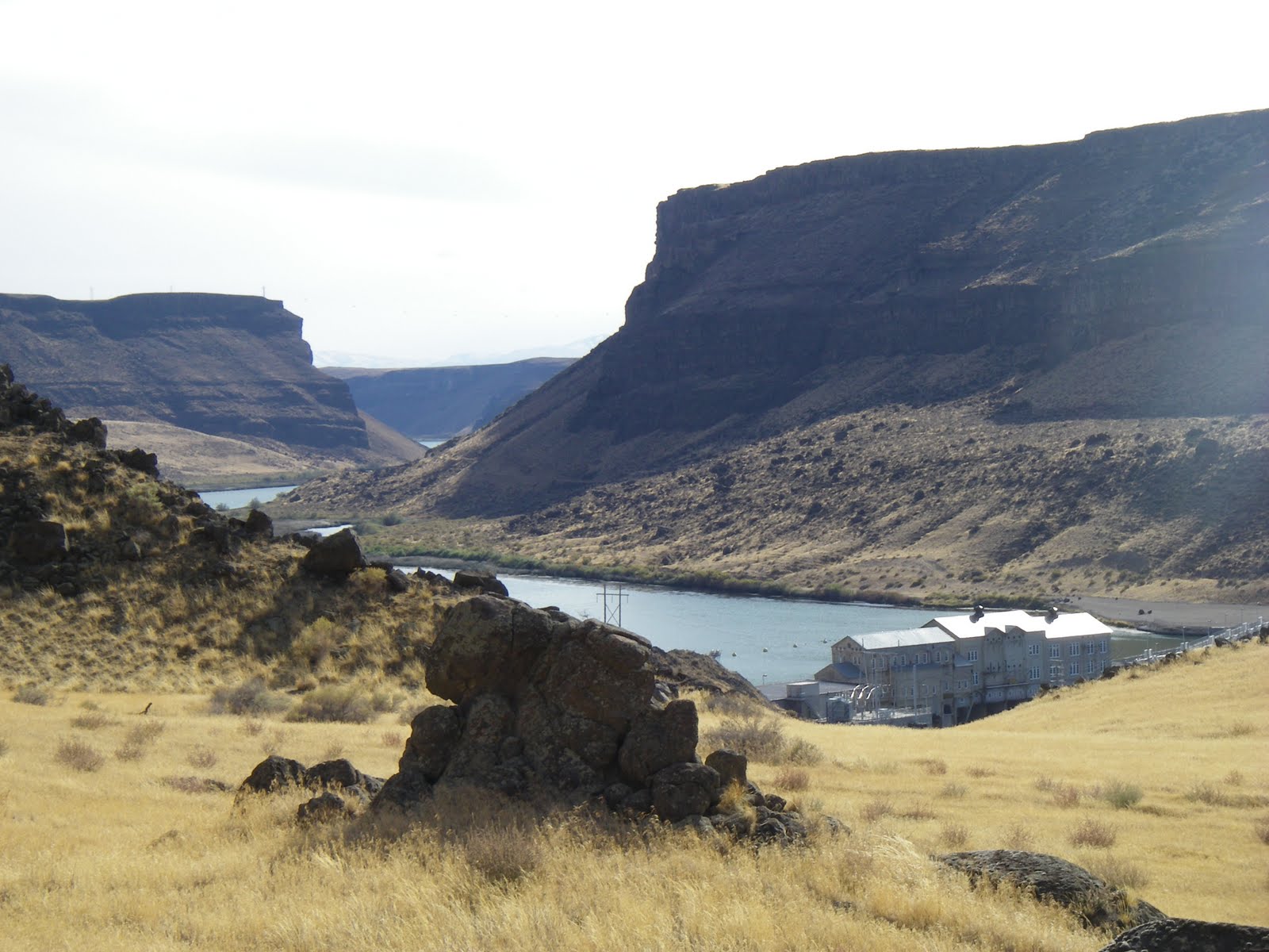
Canyon view looking down at Swan Falls Dam
Many pairs of golden eagles nest in the Snake River canyon
Map to Wees Bar from the Boise Trail Guide
Hi all,

Well, we're a little stuck in between winter and spring right now, but with temperatures reaching into the mid-50s, the weather is suitable to do a little exploring in the Morley Nelson Snake River Birds of Prey National Conservation Area by Swan Falls.

This week I'm recommending going hiking, biking or running from Swan Falls Dam to Wees Bar, where one can view a variety of cool Native American petroglyphs, on the south side of the Snake River. It's 12.2 miles to Wees Bar from the dam round-trip. The biking trip is detailed in my guide, Mountain Biking Idaho, and the hiking and trail-running trips are detailed in my book, the Boise Trail Guide: 75 Hiking and Running Routes Close to Home.

It's not clear how wet it's going to be this weekend, so the trails to Wees Bar may be relatively dry or they may be a bit wet. The area around Swan Falls is typically quite dry, compared to most other areas in SW Idaho at this time of year, so it could be a good bet.

When you're on the way to Swan Falls or you're on the trail, be sure to watch for birds of prey activity. About 800 pairs of hawks, eagles, falcons and hawks nest in the birds of prey area. Bring a pair of binoculars or a spotting scope. Springtime is mating season. That means you can see the birds flying together in courtship. The aerial maneuvers can be quite impressive. Some birds nest in the cliffs, so you can check out nesting areas as well. Watch for large blotches of white in the rocks for bird nests or perching activity.

Here's a video about raptors in the the birds of prey area.

To reach Swan Falls Dam, take Interstate 84 to the Meridian Road Exit. Go south on Meridian Road to Kuna. In Kuna, follow the signs to the birds of prey area. You'll turn left on a paved road going dead south to the Snake River canyon rim. The BLM has a nice road-side stop with a rest room where you can hike out to the rim and watch for soaring birds of prey and enjoy a major view of the canyon. That's worth a stop.

Here's an overview map of the roads in the area.

Proceed on the paved road to Swan Falls Dam. It's a nice place for a picnic if nothing else.

To reach the trail to Wees Bar, cross the river on the dam walkway, and pick up a dirt singletrack trail to the left, heading upstream. Turn right at the first fork and follow the two-track uphill for a short distance. At mile .9, turn right on a two-track, and then at mile 1.1, turn right again to follow the main two-track that runs alongside the Snake River to Wees Bar.

At mile 3.2, you'll pass by an old ranch site. At mile 4.5, the trail bends to the left to climb around a small butte. Pass through a narrow slot in a gate and keep heading west. At mile 6, the trail becomes braided and many large boulders appear in the flood plain area called Wees Bar. Look around for the petroglyphs (ancient Native American inscriptions) on the rock.

Take a break, watch for birds of prey in the cliffs above, and retrace your tracks to the trailhead and Swan Falls Dam.

If the trail to Wees Bar seems too wet, you can bike or hike along the dirt road on the north side of the river, or drive it with a 4WD until you're ready to get out and walk and look around. There are a number of places where you can can car-camp along this road.

When the weather warms up, it's also possible to kayak, canoe or raft the Snake River down to Celebration Park. It's about 10 miles to do that float trip, and a 12-mile vehicle shuttle.
--SS

Thursday, March 3, 2011

Time to dust off the road bike and explore some of Boise's road biking loops


Hi all,

Well, here we are in the beginning of March, the tulips are beginning to sprout in my front yard, the days are getting longer, and the roads around Boise are free of snow and ready to ride.

It might be wet or a bit chilly in the next several weeks, and it might even hail or snow on a given day. But if you dress for it, now is a great time to dust off the road bike and start getting your legs in shape for a great summer of biking. Plus, the city is begging people to stay off the dirt trails in the foothills, so there's another reason to jump on the road bike. Give the foothills a break, put the hammer down and see how your legs feel.

I just re-printed the Boise Road Cycling Guide after the first edition sold out after Christmas. I'm excited about it because Northwest Printing in Meridian had a line on some cool printing stock that is made out of rock powder. The maps are still waterproof, tear-proof and, with this stock, they won't fade from sunlight or whatever. The maps are chlorine-free and take zero water to produce. That's a real plus for a printed product.

The guides cost $12.50. They've available in all of the bike shops in the valley, including REI. I don't want to toot my horn too much but the two-sided map with 30 rides valley-wide is the only road biking guide in the Boise area. Here what Mark Solon of Boise said about the guide. "It's my bible for road biking in the Boise area."

In this blog, I'm recommending four particular road biking rides to get your legs warmed up, starting with a couple of easy rides and working up from there. All of them are less than 30 miles. The road cycling guide has more than 30 rides overall, and almost all of them, with the exception of the Ride to Bogus, are snow-free.

1. Municipal Park to Barber Park Loop - Rated easy. 10 miles. Ride time: 1 hour.

Start from Municipal Park in east Boise, near Idaho Fish and Game headquarters on Walnut Street. Go east on the Greenbelt 4.2 miles. Turn right and take the path to Barber Park. Follow the paved path to the left of the park entrance and follow that through a number of neighborhoods for several miles. Ride on the detached pathway along ParkCenter Blvd., turn right on River Run Driver, follow the bike lane to the paved Greenbelt access and ride to Broadway bridge. Cross the river at Broadway, turn right, and return to Municipal Park.

2. Municipal Park to Discovery Park (foot of Lucky Peak Dam) - Rated easy to moderate. 9 miles one-way, 18 miles round-trip. Ride time: 1 to 1.5 hours.
Start from Municipal Park near Warm Springs and Walnut. Go east on the Greenbelt 9 miles to Discovery Park. It's slightly uphill - 140 feet of gain. But wind will be a much bigger factor on the ride. In the winter, you may ride into the teeth of an east wind on the way out, and zoom back with a tail-wind. In the summer, it's the reverse. Take a breather at the park; do some stretching, have a snack, drink some water, and ride back to Municipal Park.

3. Municipal Park to Hilltop Summit and back - Rated strenuous. 27 miles round-trip. Ride time: 2.5 hours at a recreation pace.

Now is a good time to ride to Hilltop because the traffic isn't nearly as heavy as it is in the summer. Watch for mule deer and elk. Start from Municipal Park near Warm Springs and Walnut. Go east on the Greenbelt 9 miles to Discovery Park. Jump on Idaho Highway 21 and climb the grade to the top of Lucky Peak, and keep going to Hilltop Summit. It's an additional 4.5 miles from Discovery Park to Hilltop. Don's Kodiak Grill is at the summit if you want to stop for a beverage or something to eat.

4. Boise Bench Airport Tour - Rated moderate. 21.2 miles. Ride time: 2 hours.

This is a good tour of the upper Boise Bench. It can get really windy out on Gowen Road so be ready for that. Start at Municipal Park near Warm Springs and Walnut. Go east on the Greenbelt 6.7 miles and turn right on the Idaho 21 connector to Gowen Road. There is a good shoulder. At the junction, with Gowen Road at mile 10, go straight and beeline to Orchard. Enjoy the tour of the National Guard facilities and the Boise Airport. At mile 14.3, go right on Orchard. Go three miles and turn right on Kootenai, a leafy neighborhood on the bench. At mile 19, go straight on Protest, drop down the hill, follow Beacon over to Broadway. Turn left on Broadway, cross the river, and take the Greenbelt back to Municipal Park.

- SS