Thursday, June 28, 2018

Heading to Stanley for 4th of July? Five rock-solid ideas for hiking and biking in the area

Group at Bench Lakes (courtesy of Knowles Gallery.) 
Hi all,

I sure am enjoying the cooler weather that we're experiencing right now, and it is expected to stay on the cooler side for the 4th of July holiday if you're planning on heading into the mountains. High temperatures are expected to be in the low 70s in the mountains this weekend (60s on Friday), and continuing into next week for the holiday. Perfect weather for hiking and biking!

I did a post recently on some popular and scenic trails that are open for hiking and biking in the McCall area, and so for this week, I'm recommending 5 rock-solid ideas in the Stanley area. These are mostly hikes and one ride. Overall, I am hearing that snow levels are between 8,500-9,000 feet in the Stanley area, creek crossings are high and hazardous (bring hiking poles and a rope for safety), but the snow is melting quickly. 

As you break out of the trees on the Boundary Creek Trail, the views get more and more spectacular. 
1. Boundary Creek Trail in the White Cloud Mountains - The Boundary Creek Trail rises steeply from the valley floor (trailhead is across Idaho 75 from the Sawtooth Hatchery), and for that reason, the trail affords magnificent views of the Sawtooth Valley, the Sawtooth Mountains and Redfish Lake as you climb the mountain. Here's an online map of the trail. It's about 3 miles to the top, and 2,000 feet of climbing. Rated strenuous but worth the effort for the big view! This trail is best for hiking, but hard-core strong bikers could climb it as well.

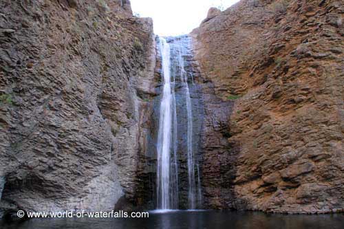
Bridal Veil Falls (courtesy of Idaho Campground Review) 
2. Hike to Bridal Veil Falls from Stanley Lake - Roundtrip distance is about 8 miles. Only 570 feet of elevation gain. Rated easy to moderate. This is a popular hike for good reason ... it's very scenic at the falls. Here's a nice writeup on the trip with a short video of the falls. 

3. Hike to Bench Lakes from Redfish Lake Lodge - Take the Bench Lakes trail from the trailhead next to Redfish Lake Lodge and hike to one of the lower Bench Lakes. The uppermost lakes are likely to be snow-bound. There are five lakes overall. Here's a nice writeup from the Outbound Collective. Distance round-trip is about 8 miles, depending on which lake you go to. Rated easy to moderate.

Hell Roaring Lake (courtesy of Idaho Campground Review)
4. Hike to Hell Roaring Lake or Imogene Lake in the Sawtooths - It's an easy 5.5-mile hike to Hell Roaring Lake in the Sawtooths. You'll need a 4WD vehicle to reach the trailhead. The trail is pretty flat, less than 1,000 feet of elevation gain. But the payoff is big with spectacular views of the Sawtooths at the lake, and super cool view of the Finger of Fate. See writeup and pics courtesy of Matt Leidecker, author of excellent full-color guides to the Sawtooths and the White Clouds.

Margie and a couple of teen-age boys loved the Potato Mountain Ride ... Quinn wasn't so sure at the time. 
5. Ride the Potato Mountain Loop near Stanley - This is one of my favorite bike rides. The crossing of Big Basin Creek might be kind of gnarley this time of year, but it sure is fun to do the ride. It's about 13.5 miles to do the loop. It starts out kind of steep but once you get over the hill and drop into Little Basin Creek, you're smiling all the way. The trail runs very close to the creek. See full description on the MTB Project site. I took my son Quinn on this ride when he was about 13, and he whined most of the way, but he survived. Several other teen-age kids went with us. So that's an option if you want to take kids.

Have a great 4th of July holiday!
- SS  

Thursday, June 21, 2018

What's on your list for summer fun? Steve's Top 10 must-do, must-see outdoor list

Climb a mountain is one of my recommendations ... this is in the Pioneers near Stanhope Peak. 
Hi all,

Today, June 21, marks the official beginning of summer, and also the Summer Equinox, the longest day of the year. The weather is warming into the 80s in the afternoons, so it's pretty much perfect weather conditions for just about anything outdoors. Welcome to summer!

To celebrate this moment in time, I am recommending 10 must-see, must-do activities for the summer of 2018:

1. Float a river (day trip) - we're blessed with so many options here, but the summer season opens on the Boise River at Barber Park at noon on Friday, June 22. Warm summer weather also gets people jazzed about floating the Payette River, either the Main Payette, South Fork Payette or Cabarton run on the North Fork. Check with Cascade Raft & Kayak, Idaho Whitewater Unlimited and the Payette River Company about guided trips. The Payette's calmer sections are great for stand-up paddle boarding (SUP), sit-on-top kayaking and canoeing.

Float a river! This is on the Cabarton stretch of the Payette River. 
2. Climb a mountain - The pinnacle is to climb Mount Borah, but there are so many other options in Idaho, with dozens of peaks over 10,000 feet and 8 peaks over 12,000 feet. See Idaho mountain expert Tom Lopez's list of recommended mountain peaks. McCall mountain expert John Platt also has an extensive list of peaks and mountains that he's climbed. 

3. Ride the ski lift to the top of Bogus Basin, Brundage Mountain or Sun Valley and go hiking or biking from there.

4. Take your kids fishing - See the list of Idaho Fish and Game's Family Fishing Waters to find some great recommendations close to home.

Go hiking in the Sawtooths (photo courtesy Michael Lanza/The Big Outside)
5. Go backpacking in the Sawtooths, White Clouds, Pioneers or Big Lost Mountain Range. See Michael Lanza's recommended hikes in the Sawtooths in his blog, the Big Outside. See a recommended major loop in the White Clouds in Backpacker mag. For a great hike in the Pioneers, see my blog post about hiking Broad Canyon. For the Big Lost range, see this overview in Summit Post.com.   

6. Sleep under the stars in a dark sky venue like Bear Valley, the Owyhee Canyonlands or outside of Stanley.

Catch a trout on the Middle Fork Salmon River. 
7. Fly into the Middle Fork of the Salmon River and go fly-fishing for native cutthroat trout. Air taxi services in Boise, Cascade or McCall can take you into the Middle Fork in less than an hour. All fishing is catch and release.

8. Go mountain biking on a classic loop trail like Fisher-Williams in the White Clouds, Loon Lake north of McCall or Around the Mountain at Bogus Basin. 

Climbing up a short hill to finish the Fisher-Williams Loop (courtesy Salsa cycles)
9. Go SUP'ing, boating or swimming in a refreshing, natural Idaho mountain lake like Payette Lake, Redfish Lake, or Priest Lake.

10. Go see an outdoor concert! See Michael Deed's column in the Idaho Statesman for a full rundown of outdoor concerts planned in the summer of 2018.

For further enrichment on Idaho bucket list trips, see an Idaho bucket list post from Boise State radio, and a post that I did listing another 30 bucket list trips that they didn't cover. 
- SS

Thursday, June 7, 2018

Five premium mountain bike rides to get your adrenaline and fun meter in the red zone

Flowers are blooming in Ponderosa State Park right now along the super fun Huckleberry Trail 
Lunch break at Loon Lake 
Friends Barb and Paul on Jug Mountain Ranch singletrack 
Hi all,

The weather is supposed to cool off markedly this weekend, particularly on Sunday when it's supposed to hit only 65 degrees as high in the Boise Valley. In McCall, Stanley and Sun Valley, it will be much cooler with rain and snow in the high elevations predicted.

But neverthless, for this week's outdoor tip, I'm recommending five premium mountain biker rides in Boise and McCall that are in good shape and ready to ride as of today ... the McCall trails will get wet this weekend, but the weather is supposed to snap back to warm temperatures by Tuesday and Wednesday. The summer season is upon us, and the kids are out of school!

The rides:


Typical view of Around the Mountain Trail on the backside of Bogus ... super fun! 
1. Around the Mountain at Bogus Basin - Distance 10 miles, riding time 1.5 hours, 1,500' vertical gain. This was voted as the best ride in Idaho by IMBA ... I'm not sure I agree with that, but it's definitely in the top 10. Bogus Basin is open for summer operations. See their web site for more information.

2. Eastside-Stack Rock-Sweet Connie-Chukar Butte to Boise - I'm not sure of the distance of this ride but I'd guess it's close to 20 miles if you end up at in Hidden Springs on Dry Creek Road at the bottom of Chukar Butte. Vertical drop has to be about 3,000-feet plus. This is a huge long downhill that's much improved with the trail-enhancement work that'd been done on Sweet Connie. Shuttle to the Eastside trailhead, ride Entrance Exam to Eastside to Stack Rock then take Sweet Connie downhill to Chukar Butte and go right on Chukar Butte over to Hidden Springs. This is probably one of the coolest downhill rides that you can do in the Boise area.

3. Jug Mountain Ranch, Lake Fork - The trails at Jug are opening up for lots of fun and enjoyment. See the latest list of JMR trails at this link. They've built a new beginner downhill trail called "Doe-Joe." I'm looking forward to riding it. It looks like Doe-Joe connects to Berm & Ernie, which is a super-fun flowy trail with banked corners. Another great loop is to take South Elk over to the South Boundary Road, climb that to Murphy Jct., climb to the Jug Reservoir, ride the Shoreline Trail around the lake, then take Vendelay downhill to Harper's Hollow and finish out on North Elk back to the trailhead.
JMR trail system map (courtesy JMR)
4. Loon Lake Loop - I checked with the McCall Ranger District and the trail has been cleared to the Secesh River. You may encounter a few downed trees on the way back along the Secesh River to the trailhead. Distance: 10 miles. Difficulty: Strong intermediate. Travel time: 2-3 hours. Bring a lunch and enjoy a picnic at Loon Lake. Here's the MTB project writeup on the larger Loon Lake Loop.
Here's a writeup and video on the 10-mile loop in my blog.

5. Huckleberry Trail Loop at Ponderosa Park - Distance 6 miles; riding time 1+ hour; vertical gain, 750 feet, Difficulty: Strong intermediate. Park staff built more singletrack a couple of years ago so you can hike, run or mountain bike around the whole park peninsula. The trail has tree roots and rocks on it, and it has lots of up and down, so it's a good training ride for more challenging national forest rides in the McCall area. MTB project didn't do the whole loop, but they have a description of most of the trail.

BTW, 10 Barrel Brewing is sponsoring a downhill bike race on Sunday, called "Bogus to the Barrel." Cash prizes are at stake. There must be some talent coming into town to compete for the cash! Might be fun to watch somewhere along the course, or to participate in ...

Have fun biking!
- SS

Thursday, May 31, 2018

Snake River Raptor Fest, Big Water Blowout in Riggins and the Grand Ronde River

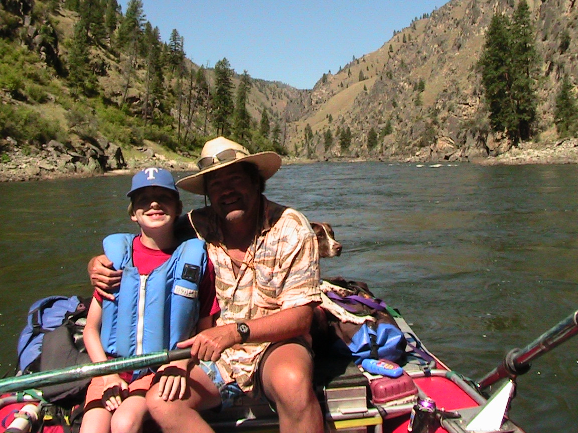
Steve on the Grand Ronde River last weekend ... 

There are many deluxe camps in the forest along the river. 
Hiking up the mountain behind camp is always rewarding and beautiful. 
Hi all,

The weather has been pretty topsy-turvy lately, with major rainstorms or hail late in the day. But the 10-day forecast for Boise and surrounding areas in the valley looks like summer is coming BIG-TIME! 

Just as we turn the page into June, forecasters are predicting temperatures in the 80s on Saturday, low 90s on Sunday, and mostly 80s through mid-month. Bring on summer!

For my outdoor tip this week, I'm recommending two weekend events and providing some recap notes from our Grand Ronde River trip in Eastern Oregon. 

First, the events ... the Snake River Raptor Fest in Kuna sounds like a lot of fun this year, particularly because of the 25th anniversary of the Morley Nelson Snake River Birds of Prey National Conservation Area, a great location at Indian Creek Winery and live music! I'll be manning a table and signing copies of Cool North Wind, a well-regarded biography of Morley Nelson's life with birds of prey. The event runs from noon to 5 p.m. There will be live birds of prey on display and kids activities as well. Hope to see you there. 

This is what one reviewer had to say about Cool North Wind"It is truly an amazing book, and a fun, entertaining, and enlightening read!" American Falconry 

BTW, I'll be on a panel at the Idaho Environmental Forum next Wednesday, June 6th, to talk about Morley Nelson as part of a discussion about the 25th anniversary of the designation of the birds of prey area. Former Congressman Larry LaRocco will be on the panel along with Amanda Hoffman, area manager of the birds of prey area for the BLM. The deadline for signing up for this IEF luncheon program is on Monday. 


The first weekend of June also marks the Big Water Blowout in Riggins ... Take a wild ride with a local outfitter or bring your own raft and try your hand at running some big water on the mighty Salmon River. The Salmon River has been flowing in 50,000-60,000 cubic feet per second range in the last week or so after two peaks over 70,000 cfs. Should be cranking in the 65,000 cfs range this weekend! 

A lot of big water whitewater boaters were at the Lochsa River Memorial Day gathering last week, so they'll be tuned up for some more big water fun in Riggins! 

For a lower-key river adventure, I would recommend running the Grand Ronde River right now. We camped on the river for 4 days last week, Thursday-Sunday, and it was a super fun time. The whole canyon is really beautiful right now, chock full of wildflowers and very green! We picked a campsite that ended up having a resident bighorn sheep herd grazing on the opposite mountain from camp. We hung out and watched the wild sheep in the morning during breakfast and also during the cocktail hour in the evening. There were at least 4 baby lambs that were chasing each other around in the rocks and a small group of about 12 sheep ... really precious to watch! 

With fairly high flows in the 9,000 cfs range, the Grand Ronde scoots along at 7-8 mph. That means you can clock a lot of miles fairly quickly, and then make a base camp. The whole section we typically run is only 35 miles in length. So we went down about 20 miles in 3 hours, base camped for 3 days, and then rowed out 15 miles the last morning. 

The put-in for the Grand Ronde is at Minam, northeast of La Grande on Highway 82 (paved road all the way to the put-in; unusual for some rivers), and the takeout is at Powatka Bridge by the Wildcat Creek road. You do drive a gravel road from the takeout to a point near the little town of Wallowa, where you jump back on the highway. Super easy drive in the whole scheme of things to do a stellar river trip. 

The Grand Ronde is great for kids, side-hiking, wildlife-watching, camping and R&R. I highly recommend it! 

- SS

Thursday, May 17, 2018

Four spring hikes - 2 in the Boise Foothills, 2 in the Owyhees, plus Boise Bike Week!

Jump Creek Falls, near Marsing
Big Jacks Creek canyon as it looks as you're hiking down from the Parker Trailhead. 
Hi all,

After a week of unsettled weather, this weekend looks fabulous with clear skies and temperatures in the mid-70s in the Treasure Valley. There's a 30 percent chance of thunderstorms on Sunday. We've seen that all week, and sometimes the storm happens, sometimes not!

My outdoor tip this week will focus on a couple of handy hikes close to home. But first, I wanted to mention this we are in the midst of Boise Bike Week, sponsored by the Treasure Valley Cycling Alliance. Tomorrow is national Bike to Work Day  So if you need a little extra motivation to get your bike lock and gear together for biking to work, there you go!!! Plus, a bunch of coffee shops are offering a free cup of coffee to people who ride to work ... so there's another boost for ya! See Boise Bike Week Facebook page for details.

Now to the hikes. First, a couple in the Boise Foothills:

Lupine going off big-time on the way to Central Ridge Trail and Bucktail Trail in Military Reserve this week. 
1. Jumpin' Jeepers Figure-8 Loop - 6.75 miles. Rated strenuous as a hike or run with moderate sections. Rated intermediate for biking. Hiking time, 2.5-3 hours; running time, 1:20; riding time, 1:10. This is one of my favorite rides in Military Reserve that connects to Shane's Trail. It's an equally nice run or hike. The name comes from the Boise Police Dept. shooting range at the end of Mountain Cove Road. The unexpected blast from a gun might cause you to jump out of your skin! Thank goodness the city finally moved the firing range! The flowers are still popping along the way ... I saw a field of arrowleaf balsomroot and purple lupine on Wednesday. To start, go to Fort Boise and then the main trailhead on Mountain Cove Road, after the sharp right-hand corner heading west. Take the Toll Road Trail #27A to #20 Ridge Crest and climb to the top of the hill. Turn right on Central Ridge Trail and climb at a moderate pace to Shane's Junction. Take Shane's #26A to the left, and climb to the top of Shane's. You've climbed 1,000 feet over 3+ miles. Give your puppy a drink and a snack. Descend Shane's for less than a mile, turn right on the Shane's Loop and return to the Central Ridge-Bucktail-Shane's jct. Take Bucktail downhill and enjoy the big GS turns as you wind across a big downhill on a large flat. Bucktail drops into the Central Ridge alternative trail. Go right and then left on that and it'll take you back to the trailhead. It's a great view of Idaho's Capital City as you cruise downhill on that sagebrush slope to the trailhead.

2. Camelsback - Kestrel-Crestline-Red Cliffs Loop - Distance: 5 miles. Rated moderate for hikers and runners. Rated intermediate for biking. Hiking time, 2-2.5 hours; Running time: 55 minutes; Biking time: 45 minutes. This is a popular loop with hikers, runners and bikers. Start at Camelsback Park off of Heron and 13th Street in North Boise. Head over to the trailhead in the east side of the park, and follow Owl's Roost Trail on the right by the ponds. Follow Owl's Roost to the Foothills Learning Center area. Turn right at the junction with Kestrel, and climb Kestrel to Crestline, it's about .6 miles of continuous climbing. Turn left onto Crestline, climb a short abrupt hill, and then watch for a left-hand junction with Red Cliffs in less than a half mile. Turn left onto Red Cliffs and enjoy a fun descent for over a mile back to Hulls Gulch. Follow Hulls back toward the Foothills Learning Center, cross 8th Street, and take Chickadee Ridge back to Camelsback Park.

Now, a couple hikes in the Owyhees:

3. Jump Creek Canyon, near Marsing - Follow this link to see a write up in the Nampa Press-Tribune about visiting Jump Creek Canyon. They used my Owyhee Canyonlands guide for reference and driving directions. Be forewarned that there is poison ivy on the trail to the falls. Watch your step and keep the kids close at hand through that small section as you approach the falls. Once you arrive at the BLM recreation site, you'll notice that you can explore some extensive trails above Jump Creek Falls. Give that a go if you're up for hiking a greater distance than the quarter-mile trail to the falls.

4. Big Jacks Creek, Parker Trailhead - Big Jacks Creek is a gorgeous canyon. Go see it and judge for yourself.
Driving map for Parker Trailhead
The hardest part of the whole trip, like many in the Owyhee Canyonlands, is finding the trailhead. A good 4WD vehicle or a high-clearance Subaru is recommended for the drive, once you hit the dirt roads.

How to get there: Take the freeway to Mountain Home. Take the first exit. Follow signs for Idaho State Highway 51 and Bruneau. After you reach Bruneau, take note of your odometer. Stay on Idaho 51 for approximately 25 miles. You'll be watching for a right-hand turn on a good dirt road, called the Wickahoney Road, just past milepost 45. The road is not signed, but it's a BLM public road.

Follow Wickahoney Road 4.9 miles to a T-junction by Wickahoney Creek. Turn right and go 2.8 miles to the Parker Trailhead. Park and hike from there.
Leo Hennessy follows the Parker Trail into the Big Jacks Wilderness

You'll follow a two-track road over to the rim of the canyon, walk over a barbed-wire fence via a wooden step-over gizmo, and descend into Big Jacks Creek. Take your time, take some photos and enjoy the scenery. There's a foot path going down into the canyon; it's marked by rock cairns along the way. Watch for snakes. They could be out.

Once at the bottom, you can explore a little and eat lunch by the campsite area. Return the way you came.
Beautiful campsite at the bottom of Big Jacks. 
----------------------------------------------------------
The BLM is hosting two events this weekend related to the 25th anniversary of the Morley Nelson Snake River Birds of Prey National Conservation Area.

1. Join in on a Naturalist Photo Safari of overlooked and underappreciated components of the NCA ecosystem. On Saturday, it's "Insect Day." On Sunday, there's a plant and geology hike in the canyon. RSVP to Cory Coffman at ccoffman@blm.gov. For the full event schedule, go here.

Have fun!
- SS

Thursday, May 10, 2018

Riggins SCAT machine closure requires Idaho river floaters to find alternatives - FAST!

Drew and Dad on the Main Salmon River ... my old rocket box toilet won't be the best to use anymore!  
Hi all,

This week's tip is for Idaho's river floaters. News flash: The SCAT machine in Riggins has been shut down by Gem Stop and the city of Riggins. The U.S. Forest Service is working on a new solution, but not until 2019. If you're planning on running the Main Salmon River - River of No Return Wilderness section this summer, you'll have to find another way to dispose of human waste.

I wrote a full story about this debacle in Idaho Statesman Outdoors. Click on the link to read all about it! Not everyone reads the paper these days!

My solution? Invest in a new portable toilet that has a 3-inch hose that hooks up to an RV dump. Then I'm not dependent on SCAT machines. If I'm floating the Bruneau or the Owyhee river, I'll have a good way to dispose of human waste in Boise after the trip. See the article for information on RV-compatible portable toilets.


If you liked seeing Shoshone Falls in full glory at big river flows, you'll love seeing the 212-foot falls illuminated with lights and lasers synchronized with music! Southern Idaho Tourism is putting on a light and laser show for three nights running next Thursday-Sunday, May 17-19. River levels are still big and impressive! Tickets are on sale now, and they will sell out. Should be super-cool!  

A couple of other tidbits: 
  • Ridge to Rivers is hosting a volunteer trail project in the Hillside to the Hollow area on National Trails Day, Saturday, June 2. R2R will be constructing a 1/4-mile neighborhood access trail in the H2H Reserve from 9 am to 1 pm. Volunteers should come prepared to work.  Gloves, closed-toed shoes and long pants are all highly recommended. Also, bring something to eat (snacks) and plenty of WATER! A backpack to carry these items is also a good idea. Plan on 4-5 hours of work. R2R staff will provide tools and instruction. To sign up, follow this link: https://bit.ly/2w7YRjn
  • Friends of the Owyhee are hosting a cleanup party and noxious weed knock-out event at Succor Creek State Recreation Area on Sunday, June 3, from 9 a.m. to 3 p.m. Also highly recommended to wear long pants, bring gloves for pulling weeds, and bring plenty of snacks and water. More information on their Facebook invite page.
- SS

Thursday, May 3, 2018

Station Creek hike is a primo option in May - it's bursting with wildflowers and very green

On top of 5,122-foot Bald Mountain with its weird lightning-rod thingy marking the summit. 
Arrowleaf balsomroot was blooming from near the trailhead to the top of the mountain, depending on aspect 
The trail climbs next to Station Creek to begin with, and then switch-backs over to the ridge
for a sweet ridge walk under the stately ponderosa pines
Bald Mountain, the destination, looms off in the distance ... 
Hi all,

Every once in a while, I like to revisit my favorite hikes for a little inspiration and fresh pictures. Knowing that wildflowers are popping with gusto right now in the lower elevations, I thought it'd be a great time to revisit the Station Creek Trail in Garden Valley and climb Bald Mountain. I saw flowers from the trailhead all the way to the top of the peak.

As I did the hike today, I thought that Bald Mountain would be a worthy addition to the Boise Grand Slam Peaks, if there were such a thing as a 5-base hit. Even if the terminology is off, climbing Bald Mountain is very similar to climbing Mt. Cervidae or Kepros Peak, but it's much more scenic in a forested setting with large ponderosa pine trees, grassy benches, shade and wildflowers.

Huck takes in the view of Garden Valley at the top of the initial ridge ... 
The Station-Creek to Bald Mountain hike is 3.5 miles one-way, or 7 miles round trip. The hike features more than 2,000 feet of vertical gain, starting at a base elevation of 3,170 feet across from the Garden Valley Ranger Station, and climbing to the 5,122-foot Bald Mountain Summit. There are some extra up and downs along the way. Hiking time for me was a little less than 4 hours at a pretty brisk pace. Pack a lunch for the top.

This is a very kid-friendly hike, especially for kids 8 and up. They'll probably beat you to the top. Another thing to note about this hike is that it's probably the best hike in the Boise National Forest close to Boise because it's got a good trail, there's no downfall, and the whole area is beautiful and green -- it's a rare spot in the Boise NF that hasn't been burned.       

The weather forecast this weekend in Garden Valley looks pretty ideal for Friday and Saturday, with highs in the high 70s. Sunday looks a little unstable with chances of showers and thunder-showers.

The Station Creek hike is featured in my book, the Boise Trail Guide: 90 Hiking & Running Routes Close to Home. I rate it "moderate" to "strenuous" in terms of difficulty -- but moderate overall. It's got some steep sections as you approach the first initial ridge, and then another super-steep section as you approach the top of Bald Mountain. All doable. 
Scott Mountain off in the distance to the north ... it's an 8,000-footer with plenty of snow on top. 
The trailhead is about 1 hour to 1:15 from Boise via Idaho 55 and the the Banks to Lowman Road. Take ID 55 to Banks, turn right to Garden Valley. Proceed past the town of Garden Valley to the big airstrip and Garden Valley Ranger Station. The Station Creek Trailhead is directly across the road from the ranger station. The road to the trailhead will veer off to the left of the highway before you reach the ranger station. There's public parking at the trailhead but no rest room. 

At the top of the first ridge (mile 2.1), you can go right and follow a faint foot trail to Bald
Mountain for a bigger view and a more complete experience. It's worth the extra work to get there. Return to the ridge junction and cruise back to the trailhead. 


A faint foot trail leads from the first ridge over to Bald Mountain, just a delightful walk ... 
After the hike, you can hit a local hot springs and/or have a burger in Crouch at the Longhorn Saloon. There are many places to camp in the area, particularly along the Middle Fork Payette Road north of Crouch, or you could stay at a Bed & Breakfast, the Garden Valley Hotel, or rent a private cabin. Check out the Garden Valley Chamber of Commerce web site for more information.

Have fun!
- SS