Showing posts with label Bruneau Dunes State Park. Show all posts

Thursday, April 14, 2022

It's been snowy, rainy and wet! Five rock-solid ideas for all-weather hiking trails this weekend!

Bruneau Dunes State Park

Hi all, 

It's been quite the rebound to winter-like conditions in the Boise Valley and greater Southwest Idaho in the last 10 days, plus plenty of spring rain, hail and graupel. That's an awesome thing for our water supply! 

It should be obvious that many of the Ridge to Rivers trails are wet and soggy, and thus it's best to search for alternatives. Stay in tune with the latest conditions on R2R Trails here.  

Looking ahead to the weekend, the weather forecast looks sunny and cool on Friday, rainy on Saturday, and sunny and cool on Easter Sunday. 

New snow (1-3") is forecast at Bogus Basin for a special bonus day on Saturday. Sun Valley is operating 7 days a week through Sunday, April 17.  

So if you're itching to make a few more turns, the skiing/riding conditions should be great at Bogus and Sun Valley. If you venture into the backcountry to go snowshoeing or backcountry skiing, you're likely to encounter DEEP snow, with over 20" of new snow that's fallen in the last 10 days, depending on location. Could be some of the best skiing of the season!   

For the valley-dwellers, I'm recommending 5 rock-solid ideas for all-weather trails that would be doable this weekend ... all of these trips are featured in my Boise Trail Guide: 95 Hiking and Running Routes Close to Home: 

1. Bruneau Dunes State Park. Pure sand. Located about 1.5 hours east of Boise. 


2. Eagle Greenbelt from Eagle Road to Glenwood. 4-6 miles one-way. You can do a loop by crossing the pedestrian bridge across the Boise River, if you wish. 


3. Snake River Trail, accessed from Celebration Park, south of Nampa. Very sandy trail to Halverson Lake or stay on the river trail to a cool old rock cabin.  


4. Harrison Hollow all-weather trail. Trailhead is by Healthwise and Highlands Hollow restaurant off of Bogus Basin Road. 1.5 miles out and back. 


 5. Walking path from River Run to Barber Park. Good all-weather surface mostly. 3 miles one-way. Start/finish in Barber Park. 


There you have it! 
- SS 

Thursday, September 19, 2019

Fall is in the air! 5 rock-solid hikes close to home in the Boise Valley


Here's Steve and Huck starting the descent into Silver City with Sawpit Mountain off to the right.
Hi all,

The recent cooling trend has felt wonderful here in mid-September. Fall is upon us, and that means we can look forward to nature putting on a show with shrubs and trees changing colors, and having cooler temperatures for outdoor outings.

The weather this weekend looks fab as the threat of rain decreases and temperatures are forecast to be mid-60s on Saturday and mid-70s on Sunday. Bluebird conditions!

For this week's outdoor tip, I'm dishing up five of my favorite rock-solid hikes close to home in Boise and SW Idaho.

I'll be giving a presentation on fall and winter hikes at Boise REI on Wednesday, Oct. 9, at 7 p.m. All five of the hikes I'm featuring today will covered in my talk. They also are in my books, Boise Trail Guide: 90 Hiking and Running Routes Close to Home, and my Owyhee Canyonlands guide. Please sign up online if you'd like to come! Good time to check on the REI sale rack, too!

Before you go, for fall hiking, let's remember to pack a few more things such as a good rain coat, a few extra upper layers, a good hat, skull cap? water, snacks and camera (your phone) and hiking poles. 

Big views off the high ridge on the Sawpit Mountain Loop
The Hikes:

1. Silver City Sawpit Mountain Loop - It's an 8-5-mile loop that circumnavigates a timbered mountain with a bald pointy cap that looms over Silver City in the high-elevation community in the Owyhees. It's rated moderate to strenuous. The fall colors in Silver City should be starting to happen anytime! I wrote about this hike last fall for Idaho Press Outdoors. Please see my story for directions and details. 

On a clear day, you can see a long ways across the Snake River Plain from the top of Bruneau Dunes 
2.  Bruneau Dunes State Park, south of Mountain Home - Take the kids and go play in the sand. Take your camping stuff if you're so included (check on space with IDPR). Easy to do in a day trip or overnight. Bruneau Dunes has a 470-foot high sandy mountain inside the park. Take a hike on the ridge of the dune. People also try to ski and snowboard the dunes. It's always a cool place to explore. 

3. Charcoal Gulch, Idaho City - Take a drive to Idaho City and go for a nice colorful hike on the Charcoal Gulch Trail, just on the outskirts of town. Find the trail by the Idaho City Airport (ever been there?) on the south side of town. There's a little trailhead on the north side of the airport. Take the Buena Vista Trail along the edge of the mountain, and then you'll see the junction for Charcoal Gulch. There are aspens and pines along the way, plus a small creek.  


Charcoal Gulch Trail weaves through ponderosa pine trees and aspens near Idaho City. (Courtesy Visit Idaho) 
4. Freddy's Stack Rock Trail - Stack Rock is a signature granite pyramid-shaped rock on a timbered ridge to the west of Bogus Basin Mountain Resort. It's a 9.5-mile hike or bike ride from the trailhead to do the loop around Freddy's Stack Rock Trail. I would rate the hike/ride as moderate to strenuous because of a number of continuous uphills along the way, the distance and 2,600-vertical-foot gain/loss. You're walking/riding in the pines throughout the route, except when you get to Stack Rock, so that makes it scenic and intimate. Take a lunch to enjoy on Stack Rock.
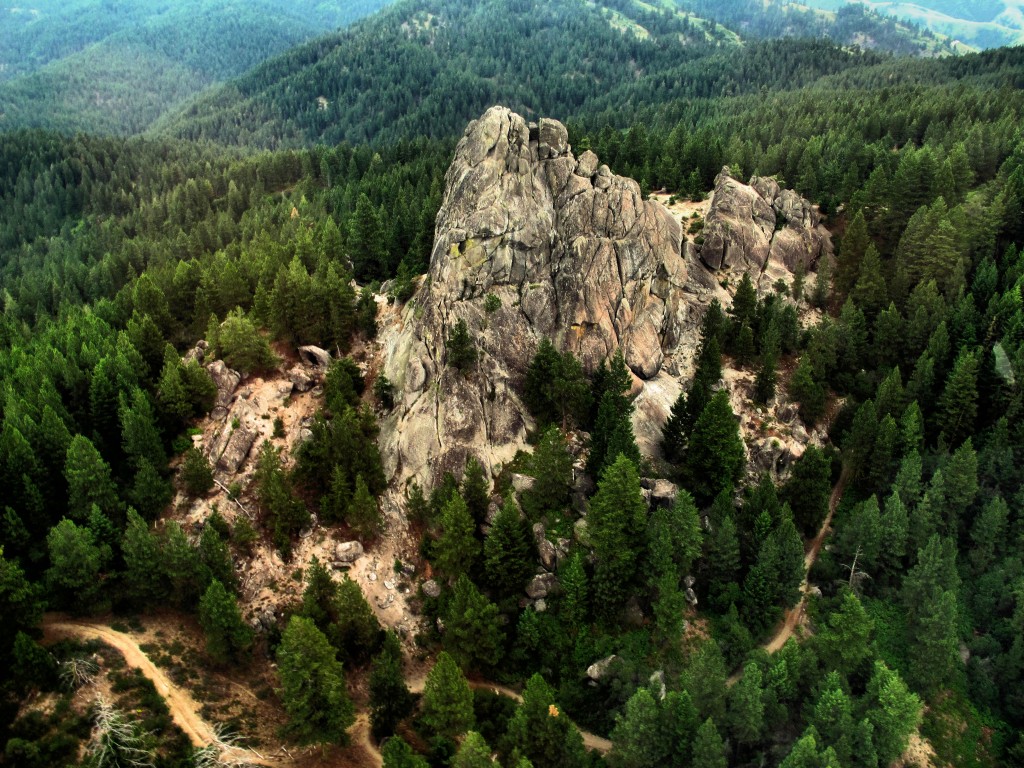
Image result for stack rock
Photo courtesy of Tom Lopez
Backstory: Approximately 1,300 acres of the Stack Rock area came into public ownership courtesy of a $1 million donation by Boise resident Fred Alleman and additional funds from the Boise Foothills Levy Committee. The land was purchased from the Terteling family in December 2009 for $1.32 million to make it available for public use.
Directions: Park in a major pullout on the left as you're heading to Bogus Basin after the road passes the turnoff to a number of cabins on the left. It's a very popular trailhead in the summer. Watch for it at about Mile 12 on the left. A new parking lot has been built up there for the Eastside trailhead on the right side of the road, too. Either works.


You'll see a number of nifty bridges on the Dry Creek Trail ... keeping your feet dry.
5. Dry Creek out and back, Boise Foothills - Dry Creek is always a pretty hike, but especially right now, it should be great. The trailhead is off of Bogus Basin Road, several miles up from Boise, on the right side, as the road begins a series of hairpin switchbacks. You'll see other cars at the trailhead. It's a big day to hike to the top of the Boise Ridge via Dry Creek (7.5 miles, 2000+ vertical feet), so just take your time and go as far as you want. 

The City of Boise is hosting some events to celebrate the 50th anniversary of the Boise River Greenbelt, including the unearthing of a time capsule today and a fun walk/run on Saturday. See the Facebook event page for details.

Have fun!
- SS 

Thursday, October 4, 2018

State Parks special! Five fall hikes in SW Idaho - Bruneau Dunes, Dry Creek and more

On a clear day, you can see a long ways across the Snake River Plain from the top of Bruneau Dunes 
Hi all,

Sure nice to get some moisture today, we certainly need it, but a continued unstable weather pattern will bring us more moisture on Saturday as well. That leaves Friday and Sunday as the best days to get outside and play this weekend.

I gave a presentation on my favorite fall/winter hikes close to home last night at Boise REI, so it seemed like a good idea to share a few of those gems with you for my outdoor tip of the week.

I touched on 25+ hikes from my Boise Trail Guide and Owyhee Canyonlands guides, so that's WAY too much info. to share here, so I'll shake the dice and deliver five of them ... suitable for this weekend:

  • Bruneau Dunes State Park, south of Mountain Home - Take the kids and go play in the sand. Take your camping stuff if you're so included (check on space with IDPR). Easy to do in a day trip or overnight. Bruneau Dunes has a 470-foot high sandy mountain inside the park. Take a hike on the ridge of the dune. People also try to ski and snowboard the dunes. It's always a cool place to explore. 
    These were our GPS tracks of doing a loop around the dunes (light green line)
  • Eagle Island State Park in west Eagle - Take a 5-mile hike in the park to tour both channels of the Boise River. The trails in the park are generally well-drained with gravel along the river. Hiking time: 2 hours; Vertical rise: 55 feet (essentially flat). Rated: Easy. Make sure you buy one of those $10 annual park passes with your vehicle registration so you have a free pass to get into any state parks in Idaho. Well worth it!! 


  • Huckleberry Trail in Ponderosa State Park - If you happen to be in McCall, the "Huck" is especially colorful right now. Wendy and I did the loop 2 weeks ago, and it was really starting to light up! It's about 3.5 miles to do the loop. 400 feet of vertical gain. Hiking time: 2 hours. Biking time is 45 minutes to 1+ hours, depending on your speed. The trail has lots of rocks and roots, but the views are wonderful -- you look out on Payette Lake as you tour of the peninsula. You can climb to the top of Osprey Point at the mid-point for a nice overview of Payette Lake and the surrounding mountains. Do this hike on Sunday. The air will be crisp in McCall -- a high of 52 is forecast. 
    Wendy enjoyed the fall colors on the Huckleberry Trail in Ponderosa State Park. 
  • Charcoal Gulch, Idaho City - Take a drive to Idaho City and go for a nice colorful hike on the Charcoal Gulch Trail, just on the outskirts of town. Find the trail by the Idaho City Airport (ever been there?) on the south side of town. There's a little trailhead on the north side of the airport. Take the Buena Vista Trail along the edge of the mountain, and then you'll see the junction for Charcoal Gulch. There are aspens and pines along the way, plus a small creek.  
    Charcoal Gulch Trail weaves through ponderosa pine trees and aspens near Idaho City. (Courtesy Visit Idaho) 
  • Dry Creek out and back, Boise Foothills - Friday afternoon or Sunday should be a good day to go for a walk on Dry Creek. The colors should be getting good up there, too! The trailhead is off of Bogus Basin Road, several miles up from Boise, on the right side, as the road begins a series of hairpin switchbacks. You'll see other cars at the trailhead. It's a big day to hike to the top of the Boise Ridge via Dry Creek (7.5 miles, 2000+ vertical feet), so just take your time and go as far as you want.
    Steve rides one of the nice bridges across the Dry Creek
    Trail in the upper Boise Foothills. 
  • Bonus #6: Head up to Bogus Bogus, ride the chairlift and go for a bike ride or hike from the top of Deer Point lift. I saw that they are running the lifts on Saturdays and Sundays through October. The promotion this weekend is that if parents buy their college student a season pass ($160), the whole family gets to ride the chairlift for free.   
---------------------------------------------
A few notes:

  • Our friends at the Idaho Foundation for Parks and Lands wanted me to share that they have raised enough money to pay for restoring the Plantation pedestrian bridge on the Boise River Greenbelt. It may be installed by next spring! 
  • The Idaho Whitewater Association will be doing a litter pickup project along the Payette River on Saturday. See Facebook event for more information.

Thursday, April 28, 2016

Weekend weather looks perfect for exploring Bruneau Dunes, Bruneau Canyon & Big Jacks

Steve on top of the dunes. Wearing boots and gators to keep sand out of shoes.
Big Jacks Creek photographed from the Parker Trail
Bruneau Canyon upriver 
Bruneau River Canyon from the Overlook (courtesy VisitIdaho.org)
Hi all,

The weekend weather promises to be partly cloudy and relatively cool, with highs in the low 70s -- perfect for hiking in the Owyhees. Last week, I recommended Wildcat Canyon near Marsing. This week, I'm recommending three outings in the Owyhees near Bruneau, south of Mountain Home.

I'm recommending Bruneau Dunes State Park, the Bruneau Canyon overlook, and Big Jack's Creek, the Parker Trail. All of these destinations are knock-your-socks-off scenic with fun exploring opportunities and optional camping. All of these destinations are detailed in my guide, Owyhee Canyonlands: An Outdoor Adventure Guide,. which features 55 hikes and bike rides in the vast, 5-million-acre area south of the Treasure Valley. 

So let's get to it!
  • Bruneau Dunes State Park - Go visit North America's tallest single-structured dune, 470 feet high. It's easy to climb up there and cross the top sandy ridgeline of the dune, and check out the other smaller dunes in the area. There's also some fishing there at the park, and the camping at Bruneau Dunes is absolutely first-class with services. Distance: 3 mile loop. Travel time: 1-2 hours at a very leisurely pace. Bring the kids! Great place for them to play. Pack a lunch. Bring plenty of food and water. Trail map here. Buy a $10 state parks pass with your vehicle registration so you can get free entry into any of Idaho's state parks year-round. Awesome deal! How to get there: Take I-84 to Mountain Home. Take the first exit and go south on Idaho 51 towards Bruneau. Cross the Snake River and then turn left and follow signs to the park.
  • Bruneau Canyon Overlook - This is another family friendly adventure to go see the yawning Bruneau River Canyon, 18 miles south of the town of Bruneau. The canyon is 800 feet deep from the top of the rim down to the rushing river. It's super cool to check out the layer-cake like geology of the canyon. Multiple layers of volcanic basalt and rhyolite are exposed in the canyon. If you don't have a copy of "Roadside Geology of Idaho," I heartily recommend it. How to get there: Take I-84 to Mountain Home. Take the first exit and go south on Idaho 51 to Bruneau. Pick up any last-minute items at the market in town, then turn left on Hot Springs Road and follow that south of town. After 8.5 miles, go left on the Clover Creek-Three Creek Road, a good-quality gravel road. 15 miles south of Bruneau, you'll see a BLM sign on the right, indicating the turn for the overlook. You could self-support camp in that area. You also could hike or bike on the two-tracks next to the overlook.  
  • Big Jack's Creek, Parker Trail - Distance: 2.5 miles; rated moderate to strenuous. Travel time: 2 hours or more. Pack a lunch and make a day out of it! Big Jacks Creek is a gorgeous, vertical redrock canyon, carved out of rhyolite lava. The Parker Trail is a rare developed trail anywhere in the Owyhee Canyonlands where a person can follow a trail tread from the canyon rim to the creek-bottom. It's about 1.25 miles down to the bottom. You'll come to a nice rock outcropping 1 mile down the trail, a nice spot for a photograph. There's a sweet campsite at the bottom of the trail next to Big Jacks Creek. So this trip has backpacking and camping potential. 


    How to get there
    From Boise, take I-84 east to Mountain Home. Take the first exit. Follow signs for Idaho State Highway 51 and Bruneau. After you reach Bruneau, take note of your odometer. Stay on Idaho 51, going south, for approximately 27 miles. You'll be watching for a right-hand turn on a good dirt road, called the Wickahoney Road, just past milepost 45. The road is not signed, but it's a BLM public road. Follow the Wickahoney Road 4.9 miles to a T-junction by Wickahoney Creek. Turn right and go 2.8 miles to the Parker Trailhead. The road is rougher for the last 2.8 miles. Higher-clearance AWD recommended. 
Have a great weekend!
-SS  

Thursday, March 21, 2013

Some spring camping suggestions for Spring Break in the desert country of SW Idaho

Here's Steve enjoying the view atop the Bruneau Dunes 
Cool rock formations to explore at Succor Creek State Natural Area. 
Morley Nelson Snake River Birds of Prey National Conservation Area 
Leslie Gulch 
Steens Mountain from a distance 
Hi all,

With the mercury heading into the 60s next week, it's a perfect time to plan a spring family camping trip during Spring Break. After a couple of cooler days this weekend, it's supposed to warm up to the 60s by Tuesday in Boise, and in the lower-elevation desert locations in SW Idaho, it could be even warmer. In fact, it's supposed to be nearly as warm in SW Idaho next week as it is in Moab, Utah. Time to load up the truck and go!

Here are some suggested camping destinations with possible side activities that you can enjoy while you're there:

  • Bruneau Dunes State Park - South of Mountain Home on Highway 51, Bruneau Dunes is a great place to camp, hike around on the dunes, and star-gaze. Call ahead for reservations. The park has the tallest single-structured sand dune in North America, rising 470 feet above the desert floor. Great views of the Snake River Valley from the top of the dunes. Take gators to keep sand out of your boots during the hike.   
  • Morley Nelson Snake River Birds of Prey National Conservation Area - Go south of Kuna to Swan Falls Dam, drive downriver on the north side of the canyon on a bumpy dirt road and find a primitive campsite. Self-support camping. Bring your binoculars and your bird book ... there are more than 800 pairs of birds of prey that nest in the canyon.
  • Celebration Park - Go south of Nampa on Idaho 45 to the Snake River and turn left to reach Celebration Park. The county's web site has detailed driving directions. It's a great place for a day trip or an overnight camping trip. The park has camping services and rest rooms. Celebration Park is Idaho's only archaeology park. It contains boulders with petroglyphs dating to 10,000 years ago, and park geology provides lessons about the Bonneville Flood.
  • Succor Creek State Natural Area - A great place to go spring camping, south and west of Homedale. I've written about Succor Creek before, describing some beautiful day-hiking opportunities from the park and camping areas. No developed services, but there is a rest room at the park. You also could climb Three Fingers while you're in the 'hood, or go explore Sage Creek, just before you arrive at the park. 
  • Leslie Gulch - Best accessed from U.S. 95, south of Marsing, Leslie Gulch is a wonderful place to visit in the spring for hiking and camping. The area also has a boat ramp and access to Owyhee Reservoir if you'd like to do a boat-and-hike trip to secret canyons inaccessible by road. The spectacular rock formations reminiscent of Southern Utah in Leslie Gulch are the big draw. Self-support camping with direct access to rest rooms.
  • Steens Mountain - Located south of Burns, OR, you can see the giant hulk of Steens Mountain from a long distance away. You can do a loop tour of Steens Mountain from the quaint little town of Frenchglen, or camp on the Alvord Desert side of the mountain, where you could camp by a lake or hit Alvord Hot Springs as a side trip. Another nearby amenity is the Malheur National Wildlife Refuge. A lot of folks go birding at Malheur and then camp at Steens.              

There you have it! Have a great Spring Break.
-SS