Thursday, September 22, 2022

Super duper weekend ahead! Three local hikes to explore in Boise, plus National Public Lands Day!

Boise Foothills trails are "the bomb" right now! Cool conditions and trails are in great shape! 
Pic of Harrison Hollow by SS

Hi all, 

After a really nice and cool week of September fall weather, it looks like we'll be shooting up into the 80s this weekend in the Boise Valley and 60s-70s in the mountains. Prime time to do just about anything outdoors while the primo fall weather lasts! 

The smoke has cleared from wildfires too in most locations, so that is a bonus! 

For my outdoor tip of the week, I'm recommending two hikes in the Boise Foothills and one at Bogus Basin for the weekend. (see below)  

First, a couple of outdoor notes

It's National Public Lands Day on Saturday, Sept. 24. You can visit National Park system properties in Idaho like Hagerman Fossil Beds National Monument, Craters of the Moon National Monument or City of Rocks for no charge. Volunteers are needed for Idaho Department of Parks and Recreation National Public Lands Day projects at City of Rocks, Castle Rocks, Harriman State Park. Follow the web link to sign up.   

South Fork Willow Creek property ... future open space? 
(Courtesy LTTV) 

The Land Trust for the Treasure Valley just announced today they need to raise $100,000 to acquire 320 acres in the Boise Foothills for protection as open space and wildlife habitat. The property, known as the South Fork Willow Creek property, is east of Avimor and bounded by the BLM on two sides. The property also has potential for recreation and walking and biking trails. If you'd like to donate, go here! 

My boater friends would appreciate the latest outdoor dispatch from Steve Dent with KIVI-TV about a group of experienced whitewater paddlers and firefighters who paddle-rafted the entire North Fork of the Payette River from top to bottom. They broke up the 15-mile continuous Class 5 white-knuckle run into sections. They completed their goal without suffering any major injuries - not to say they didn't have an occasional swimmer! Kudos to them for doing it safely! 


Courtesy Steve Dent, KIVI-TV YouTube channel 

Now, the hikes! All of these hikes are featured in my book, "Boise Trail Guide: 95 Hiking and Running Routes Close to Home." 

Table Rock trail (courtesy Outdoor Project) 

1. Castle Rock - Table Rock "Foothills on the Rocks" - full tour, 4.35 miles; Hiking time 1.5 hours; Vertical gain: 950 feet. Start/finish at the Old Pen parking lot next to the Bishop's House in East Boise. 

Take Castle Rock Trail #19 and climb .5 miles to the top of Castle Rock, a spiky basalt rock cap overlooking Quarry View Park. Turn right at the top and take the Quarry Trail along the edge of the rocks and pick up Trail #15 and cruise over toward Table Rock. The trail gets progressively steeper as you approach the south face of the mountain butte. Once on top, head over to the cross to check out the view of the Boise Valley. 

Circle back on Trail #16, a singletrack trail around the edge of the Quarry bear right on Trail #17. Thread through the giant boulders and rejoin Trail #15 to retrace your steps to the Bishop's House trailhead. 
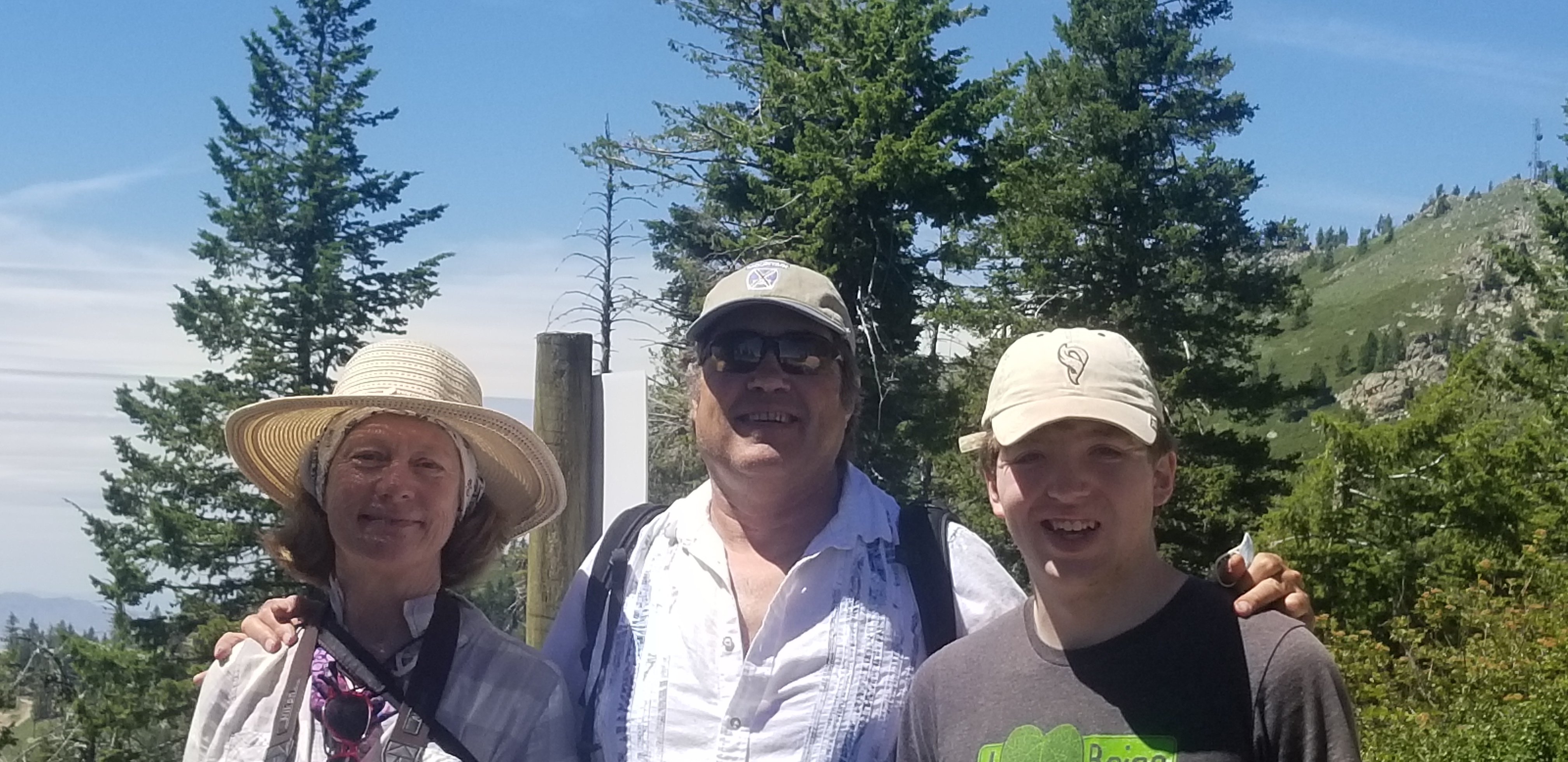
Hiking to the top of Bogus Basin with Wendy and Drew 

2. Quickest Way to Heaven at Bogus Basin - This is the name of a fun hike at Bogus in my Boise Trail Guide. It literally is the fastest way to the top on foot. Distance: 3 miles; hiking time, 1.5 hours; vertical gain: 750 feet. 

Drive to the Pioneer Lodge. Climb to the top of Morning Star chairlift and turn left on Lodge Trail #140. Follow the two-track around to the Superior side of the mountain. After one mile, you'll come to a junction where a right-turn takes you to the summit of Bogus, Shafer Butte, elevation, 7,582 feet. Bring a lunch and favorite beverage to enjoy the moment on top! 

Wendy and I went hiking last Sunday afternoon at Bogus, and we were pleased to see the BBQ is open by the lower lodge, with burgers, beers, and more! They were open till 5 p.m. Perfect way to cap off a fun day on the trails at Bogus!   

Courtesy Michelle Parsons 

3. Polecat Gulch Finger Loop - See a previous post with directions, pics and a map of this 6-mile moderate and scenic hike. Access is via N. Collister or Cartwright Road. Please note that the direction of travel for the full Polecat Loop is clockwise. R2R's has signs indicating the proper direction. From the N. Collister trailhead, you'll climb an initial hill to the top of a ridge, and then you'll see a left-hand turn for the Polecat Loop. The whole trail is narrow singletrack hiking, biking and running trail, following a series of finger ridges in the Northwest Boise foothills. One-way travel for the whole loop. 

Have fun! 
- SS 


Thursday, September 8, 2022

Dodging the fire smoke could be a challenge in the Idaho Mountains! Silver City in the Owyhees might be a good call?

Screenshot of fire/fire smoke situation Thursday afternoon via AirNow.gov
Hi all, 

It seems challenging at best to plan a trip to the mountains with the fire smoke issue being a moving target throughout the state of Idaho. 

Above, you can see the latest smoke map from airnow as of Thursday afternoon ... in McCall, we've gone from nearly clear skies and sunny weather this morning to more smoke haze and less healthy conditions outdoors in the afternoon.  

Weekend forecasts are calling for mostly clear conditions Saturday and Sunday in McCall, Stanley and Ketchum/Sun Valley, with more of a northerly airflow, and still very warm temperatures in the high 70s and mid-80s. But all of that depends on how the fires burn in the coming days between now and then and where the smoke plumes go.  


One thing we do know is that you'll want to avoid the Four Corners Fire zone west of Cascade, and points north of Ketchum from Baker Creek to the Sawtooth Valley because of the Ross Fork Fire, now burning more than 30,000 acres in the Sawtooth Range. See article in the Mountain Express about that blaze.  

Area closure map for Ross Fork fire 
Be aware that the Ross Fork Fire has closed a number of trailheads in the Sawtooth National Recreation Area. See news report with full list of the closures here

If you want to avoid smoke altogether, you might consider heading up to Silver City in the Owyhee Mountains. I've detailed several hikes and bike rides in that area in my blog and Owyhee Canyonlands guidebook. 

Sawpit Mountain Loop - 8.5-mile hike, rated moderate to strenuous. Start and finish in Silver City. See my post and article in the Idaho Press with details about that hike. This hike is featured in my guidebook on the Owyhee Canyonlands.  

Jim Young on the Silver City Skyline Tour (SS photo) 

Silver City Skyline Tour
- This is a 16.8-mile advanced mountain bike loop that circumnavigates the Silver City Valley on the ridgetops and mountain tops above ... super scenic ride! See my post with details and a map about that ride.  

------------------------
A cool volunteer opportunity is coming up in the second half of September to sweep and check on trails and camping areas in the Sawtooth National Recreation Area. It's a collaborative project led by the Idaho Conservation League, the Sawtooth Society, Idaho Rivers United, the Sawtooth NRA and more! See flier below for signup info. 

I also just blogged about ICL's Wilderness Steward program ... that may be something else people would like to get involved in next year.  

-SS 

Thursday, September 1, 2022

Trip report on Lower Salmon River + last-minute ideas for Labor Day outings

Lounging in camp with a glass of red wine apres dinner with Phil and Anna of Portland.

Hi all, 

We felt blessed to enjoy 7 days of bliss on the Lower Salmon River last week with our kids, Boise friends and Portland friends. 

For me as a Dad, it was cool to have my son Quinn (25) guiding his own raft on the Salmon River for the 3rd time and my step-daughter Elena (28) guiding her own raft for the first time. They both did great! 

The Lower Salmon is often a great fallback choice for people who have their own rafting gear. When we don't draw a permit for the Middle Fork Salmon River or the Main Salmon River River of No Return section, we often schedule a trip on the Lower Salmon instead. A self-issue permit is required by the BLM to run the Lower Salmon. You can fill out the form at the boat-launch at Hammer Creek. 

Sweet sunset on Night 3 in between rain storms. 

Our group of 12 took the whole week off from work, so we slept at the Hammer Creek put-in on Aug. 21, and launched the following morning for a 6-day, 50-mile trip. On Saturday at noon, we meet a Hammer Down River Excursions jet boat to shuttle our rafting gear to Pittsburg Landing. We also had our vehicles shuttled from Hammer Creek to Pittsburg Landing by All Rivers Shuttle Service in Whitebird. That's a lot of extra shuttling, but it saves a lot of time getting back to Boise. Plus we like to support the local businesses! 

Hammer Down and All Rivers Shuttle do a great job! I'd highly recommend them. 

The Lower Salmon could be a good bet for Labor Day weekend, but honestly, it likely will be busy as hell! You might pick another time to do the trip this fall. It'll be doable through mid-October.

Elena and her beau Chris Parri play in the sand.

Quite honestly, I've lost count of how many times I've floated the Salmon River, but maybe since I didn't do it last year, I really appreciated my time on the river this year. We were unplugged for 7 days. No cell phone coverage anywhere possible. That's always a bonus! 

Trip highlights: 

Rain!!!??? We got rained on for much of Day 1, which was a very pleasant surprise ... the temperature dropped like 20 degrees for that storm! Got more rain on the evening of Day 3, another pleasant surprise. That led to a cooler day the following day as well. 

Rapids: All went smooth. Everyone had a good run through Snow Hole Rapids, the only Class 4 drop on the trip. Everything else was read and run. Always go left, left, left in China Rapids. 


Camps
: We got several new camps we liked with shade, and we nailed Whitehouse Bar on Day/Night 3. That's one of the most awesome campsites anywhere on the Salmon River. HUGE double camp and sand bars. Also blessed to get my favorite shady camp above Blue Canyon on Day/Night 5. 

Cooking: Share the duty, is my motto! We had the perfect number of cook teams for 6 dinners, so we split that up such that each team cooked one dinner and the next breakfast the following morning. Once you're done with cook duty, you're done for the week. Everyone pitches in to do dishes. 

Quinn Stuebner and Jim Baskin 
on the jet boat ride.

My meal on Night 1 was Surf & Turf, wild salmon and Tritip, side of cauliflower, onions, and potatoes. Took a while for a 4-pound Tritip roast to cook on the grill! But that was a hearty dinner to kick things off! Blueberry pancakes and bacon for breakfast the next morning. Now you're ready to roll and make some miles on the river!!!! Stueby is ready to crack the whip. I'm kind of known for that.  

Well, enough about our trip ... here are a few thoughts on outdoorsy outings for Labor Day weekend: 

Before we get into camping ideas, Bogus Basin, Brundage Mountain and Tamarack Resort all have some fun stuff going on this weekend, and the Spirit of Boise Balloon Classic at Ann Morrison Park runs through Sunday this weekend.  

Drew and I got to go on a balloon ride with Randy Ashton of Boise this morning! Way cool! 

  • Trinity Mountains - Go camping, day-hiking or backpacking in the Trinities. I recommend driving there via Featherville. Head for Big Trinity Lake, the trailhead and general dispersed camping area. It's definitely worth backpacking into the high mountain lakes to get away from the car-campers and enjoy some good fishing!

  • Cascade area - Stolle Meadows and Landmark are my favorite camping areas in this neck of the woods. There are tons of primitive car-camping spots in both locations, east of Cascade, off the Warm Lake Highway. 
  • Lick Creek area in the Payette National Forest 
  • McCall area - Camping, hiking and backpacking in the Lick Creek area NE of McCall should be fabulous. Some of the nice mountain lakes up there include Box, Snowslide, Duck, Hum, Enos and Thirty-three lakes. Pick up a Payette National Forest map or a McCall Adventure Map to get the details for access. Also, check my blog from earlier this summer on five easy-to-access kid-friendly mountain lakes in the McCall area. 
  • Stanley area - I'm sure the Stanley area will be hopping with lots of campers at Stanley Lake, Redfish Lake, Pettit Lake and points along the Salmon River. It's still one of the most beautiful spots in Idaho!  

    North and Middle Forks of the Boise River ... car-camping mecca
     
  • Idaho City area - The North and Middle Forks of the Boise River work great for car camping. See my post from last week.  
Also, Labor Day weekend is chock full of big sales at your favorite outdoor retailers in the Boise area. If you're staying in town, great time to save money on summer outdoor gear in close-out sales. 

-SS

Thursday, August 18, 2022

Always a treat to ride Loon Lake, plus 10 more Idaho classics

Brian, Steve and Mark at Loon Lake 

Hi all, 

I was rocking out to a Grateful Dead Tribute band Friday night with a group of friends, and on the spur of the moment, three of us agreed to meet up Saturday morning in McCall to ride the Loon Lake Loop. 

Loon Lake is one of my favorite "Idaho classic" rides. Starting from Chinook Campground, about 45 minutes north of McCall via Warren Wagon Road, the ride covers 10 miles -- all singletrack -- and takes about 2-2.5 hours to complete for experienced strong riders. 1,500 feet of vertical gain. Rated: Advanced. A longer version starts at Ruby Meadows and requires a shuttle back to the trailhead or it's 22 miles if you ride the whole thing. 

Now that we're moving into late August, and September is close at hand, this is a perfect time to plan trips to bag some other "Idaho classic" mountain bike rides in Sun Valley, McCall, Central Idaho and Boise. More details about that below ... 

Trail was quite buffed last week! 

We awoke a perfect post-card day last Saturday to ride Loon Lake. High temperature of 85 forecast for the mountains. We'd had thunderstorms for two days in a row, so it was nice to see the cloudless, cobalt-blue sky on the drive going past Upper Payette Lake toward Chinook Campground. Our group consisted of Mark Anderson, Brian Ellsworth and me. 

I like to ride the Loon Lake loop counter-clockwise, so we rode across the Secesh River on the steel bridge to start the ride on Victor Creek Trail #081. You follow that singletrack trail over three different climbs and descents to a tall-grass meadow just to the south of Loon Lake. Pedal through the meadow, turn left at a junction, and ride to Loon Lake. Take a breather, have lunch, go swimming, take photos! What a spot!    

Return to the meadow, and then turn right on a singletrack that plunges into the Secesh River canyon. There's a cool little beach by the Secesh River there by the trail bridge, and then you pedal 3.5 miles back to Chinook Campground on a rocky, technical singletrack that rises and falls along the river. Watch for any spawning salmon while you're in that area. But keep your eyes on the trail, too, because there are many opportunities to crash along the way! Be careful! 

Huck at Loon Lake 

It took us 45 minutes to reach the lake, and 1.5 hours to return to the trailhead. We stopped in a few places for photo ops. Just a beautiful day! 

Wendy checking out the Secesh River on the steel bridge. 

Now, for other classic rides, I'd refer you to a story I wrote for Visit Idaho about Five Mountain Bike Rides that Shine in the Fall.  This article includes Loon Lake, Around the Mountain at Bogus Basin, Fisher-Williams Loop in the White Clouds, Gold Hill switchback special near Sandpoint, and the Lynx Trail at Farragut State Park in N. Idaho. 

Secesh River 

I wrote about five other mountain bike classics in this 2016 post from Stueby's Outdoor Journal. These rides included traversing Bear Pete Trail, the Hard Guy-Dry Creek Loop, and the Bear Basin - Brundage Lookout - Elk Trail - Growler - 488 Road - Bear Basin Ride. 
- SS  


Wednesday, August 10, 2022

Another way to Beat the Heat: Go visit an Idaho fire lookout! Some are available for rent ...


Granite Mountain Lookout near McCall (elevation 8,479 feet) 

Hi all,

I must admit, I've always had a soft spot for Idaho's fire lookouts - especially after I started mountain biking in the mid-80's, mountain-top lookouts were a natural place to go. Typically, there is a 4WD road leading to a lookout, and so you've got dirt road access, and often the climb to the lookout goes for multiple miles with several thousand feet of vertical gain, meaning you'll have a guaranteed workout to reach the summit.

Some lookouts are even more remote and require hiking a trail to the top. I've done both.  

My recommendation is to explore Idaho's lookouts whenever you can, wherever you can, work in a hike or bike ride into the outing for some exercise, and consider making plans to rent a lookout for a weekend with your honey, friends or family.

Why go? Fire lookouts, by definition, are always located on top of a high mountain peak. That's so the Forest Service lookout personnel have a big view of the surrounding countryside and can spot lightning strikes and fire starts. That means the lookout locations have a huge, 360-degree view of the mountains for miles on end -- this is one of the big payoffs.

"There's no finer way to see our state," says Gary Weber of the Forest Fire Lookout Association in a Idaho Public TV program about lookouts. 

"Idaho's Lookouts are doorways to the heavens," narrator and executive producer Bruce Reichert says. "They inspire people to visit these sanctuaries at the edge of the sky."

Lookouts can be a good place to take young kids. If there's a 4WD road to the top, you can drive to the summit and tour the top of the mountain. Mom or Dad can drive, and the other can ride or hike to the top. You know the drill.

One of the biggest benefits, I'd say from personal experience, is to experience a sunrise or sunset from a fire lookout tower. It's absolutely, utterly spectacular! Bring your camera, and pack your binoculars to look for wildlife.

Sunset from Arid Peak Lookout (courtesy Rick Gerrard) 

At one time, there were 8,000 fire lookouts nationwide, and Idaho had about 1,000 of them. Here's a website with all of the original sites. Many of the lookouts have been decommissioned over the years, but there are about 150 lookouts still standing in Idaho. I've noticed a number of sites where the lookouts no longer exist, such as on Packer John Mountain, Red Mountain, Council Mountain, etc. I bet you've seen some, too.  

Here are a few lookout towers to visit near Boise, and some possibilities for rental. Rental rates, by the way, range from $35/night to $50/night:
Scott Mountain Lookout near Garden Valley. 
  • Scott Mountain Lookout - Scott Mountain lords over Garden Valley at an elevation of 8,215 feet. You can get there via the Banks to Lowman Road, heading toward Lowman, and then head north to Scott Mountain on Forest Road 555. You can hike or mountain bike from the Scott Mountain Road junction to the top of the mountain. Be sure to bring a lunch and enjoy the views from the top. 
  • Pilot Peak Lookout - A lot of backcountry skiers know about Pilot Peak because it's an awesome backcountry skiing area. In the summer, there's a great mountain bike ride going up to the lookout, and then descending all the way to Idaho City via Bear Run Road! Plus, it's a nice hike or trail run to the lookout and back (3.5 miles each way) from Mores Creek Summit. You can access the gravel road to Pilot Peak via Mores Creek Summit on Idaho 21, about 10 miles northeast of Idaho City. 
    Sunset Mountain Lookout, 5 miles above Mores Creek Summit. 

  • Sunset Mountain Lookout - It's five miles to the top of Sunset Mountain from Mores Creek Summit. This is a good hike or bike ride. The hiking and trail-running trip to the top of Sunset L.O. are featured in my book Boise Trail Guide. I remember pedaling the baby trailer to the top of Sunset when my son Quinn was about 6 months old; it was definitely doable. Sunset has fabulous views of the North Fork of the Boise River country, and Steel Mountain and the Sawtooths are visible from the distance. 
  • Basin Butte Lookout - This one is available for rent. It's located north of Stanley in the Salmon-Challis National Forest. (need details on the approach). Forest Service Road #432 climbs to the top of Basin Butte. The turnoff is across Idaho 21 from the turnoff to Stanley Lake. Go left on the Stanley Creek road (653), and then after several miles you'll come to a fork. Go left on #432 to reach the top of Basin Butte. It's 6.3 miles and 2,750 feet of gain to the top from the turnoff. Check into rental availability at recreation.gov

    From the inside looking out at Deadwood Lookout ... this could be yours for a weekend! 

  • Deadwood Lookout - This one also is available for rent. According to recreation.govDeadwood Lookout is one of the most popular Forest Service rental cabins in Idaho. It's located on Deadwood Mountain, high above Deadwood Campground and the Deadwood River confluence with the South Fork of the Payette River. Take Forest Road #555 north from the South Fork to a junction by a campground at the top of the grade, and take a hard right on Road Road #555EC. It's less than 3 miles from the junction to the lookout.   
  • Whitehawk Mountain Lookout - This is where my son Quinn and I and our dog Huck watched the eclipse several years ago. Whitehawk is located in Bear Valley, north of Lowman. It is not available for rent as it's still manned by the Forest Service to watch for fires. 
  • Bald Mountain - This is a 50-foot-high structure that sleeps four in the Clearwater National Forest in the Hoodoo Mountains. It looks so cool, that it's certainly worth the long drive to get there. You'd want to set aside a day on either side of your lookout trip for travel time. I bet this particular lookout is in high demand because there aren't that many left that sit that high off the ground. Bald Mountain Lookout is accessed from Highway 6, near Moscow, along the White Pine Scenic Byway. There are a number of hiking and biking trails that you can tie into near the lookout. 
    Lookout Butte Lookout, 60 feet high 

  • Lookout Butte - This one also is set on top of a steel tower, 60 feet above the ground, and it's available for rent. Sleeps up to 4 people. Lookout Butte is located in the Nez Perce National Forest, and it offers fetching views of the Selway Crags, Seven Devils, Coolwater Ridge and more. It's 15 miles southwest of Lowell on Forest Roads 223, 470, 286 and 1124. 4WD recommended. There are zillions of Forest Service roads in the vicinity. Looks like a cool place to explore.        
  • Tripod Mountain Lookout - And last, but not least, we come back closer to home to visit Tripod Mountain Lookout, above Smith's Ferry. This one also is featured in my Boise Trail GuideTripod is best reached by trail on foot. You take Forest Road #626, across from the Cougar Mountain Lodge, and take that to the West Mountain Trailhead at a saddle on the road. It's 11.8 miles round-trip to the peak and back. Vertical gain is 3,160 feet. I rate it strenuous. But once you're on top of the ridge, you're glad you did it! 
Want to read/see more? 
A few years ago, I camped at the Arid Peak Lookout in the St. Joe National Forest, and wrote a feature for VisitIdaho about the experience. Highly recommend that location, too! 

Idaho Public Television featured an excellent program called "Eyes of the Forest" about a number of super-cool fire lookout towers in the state. You might watch for the re-run or see if you can watch it via the Idaho PTV web site

Have fun! 
- SS 

Thursday, August 4, 2022

Stay cool in August heat by GETTING WET early and often! Preferably in the Mountains!

Steve cooling off at North Beach in McCall

Hi all, 

I'm sure it's been a challenge for many to beat the heat lately. But if you've planned some mountain getaways at higher elevations, cooler temperatures, etc., it sure can make a difference! 

I've been impressed to read about some folks doing trips across the length of the Sawtooth Mountains, and I saw that a woman climbed all of Idaho's 12,000-foot peaks in a matter of several days. It's the middle of summer season, and it's prime time to visit the mountains and high country in Idaho! 

Wendy and I spent all of last week at our cabin in McCall. My motto every day was to exercise in the morning - often on my road bike (mountain bike is in the shop) - swim at the beginning of the ride and swim at the end of the ride before heading home. Then I'd work for a few hours in the afternoon to round out the day, and then swim again! 

Warren Wagon Road heading to Upper Payette Lake  

Our cabin is less than a mile away from the Payette Lake, 1 mile from Little Payette Lake and less than a mile from Ponderosa State Park, so it's easy to get in the water. We are fortunate to have our place in paradise! 

A few notes from our week: 

  • The greater McCall area is very busy right now. Lots of campgrounds are full. Payette Lake is busy. Even Upper Payette Lake was busy. Be sure to make a camping or lodging reservation before you go. That said, once you get outside of the center of McCall, it's less busy.
      
    Upper Payette Lake boat ramp was quiet on a Friday morning. 

  • The Meanders, a primo place for stand up paddle-boarding was busy. The North Beach parking area seemed crushed all week long. But people were still staking out their spots next to the water and having a great time! 

    The Meanders by North Beach in McCall .. primo SUP destination. 

Jim Young takes us on a Friday evening post-dinner boat ride on Payette Lake for a swim. 
Having impromptu gatherings with friends is one the great things about being in McCall. 

On Saturday, we topped off the week with a fund-raiser event with live music for Valley County Pathways and Torin Oberlindacher's 50th birthday, a trail friend. The Dusty Huckleberries were a great warm-up band, and then we had GRATEFUL - A Tribute Band in the evening. We had a big crowd, made some bucks for VC Pathways, and danced to our favorite Grateful Dead tunes. Great times! 


The Boise-based Grateful Dead tribute band will play at Brundage Mountain on Aug. 12. I highly recommend it! 

There are so many other things to do in the McCall area, including golf, backpacking, peak-bagging, fishing, mountain biking/hiking at Brundage Mountain, mountain biking/hiking/ziplining at Tamarack Resort, mountain biking/hiking at Jug Mountain Ranch, hiking/biking/swimming/camping at Ponderosa State Park, camping at Lake Cascade State Park, and exploring the Payette and Boise National Forests. Plus, floating the upper North Fork of the Payette River below McCall, below Cascade, or Cabarton. The list goes on!   

Here's Steve guiding a group through Howard's Plunge on the Cabarton reach of the Payette River. 

Don't let the summer run away without visiting McCall and the West Central Mountains
- SS 

Wednesday, July 20, 2022

Revisiting the Bitterroot Valley a welcome treat for this Montana Griz alum - 40 years later!

Top of St. Mary's Peak, 9,321 feet above sea level 

Hi all, 

Wendy and I decided to take an outdoorsy vacation in the Bitterroot Valley last week. It's only a day's drive there from Boise via Lost Trail Pass, north of Salmon or the Lochsa River corridor, north of  Grangeville. It took us 6.5 hours from McCall, driving along the Lochsa River.

The Bitterroot Valley is a gorgeous place with the Bitterroot River drawing S-curves through the center of the valley, the Bitterroot Mountain Range running north-south to the west and the Saphire Range  bookending the views to the east. 

Even though I'm a Montana griz alum, to be honest, I haven't spent much time in Western Montana since I graduated from the UM Journalism School in 1981, 40 fricking years ago! Not to date myself at all! 

The Bitterroot River with Don, Huck and Wendy

The Bitterroot Valley was literally a key part of my old stomping grounds in the five years I went to UM. My friend Don Lewis, a Journalism School classmate and I used to throw Don's aluminum canoe on top of his VW bug, and we'd zip down to Florence or Stevensville and float and fish the Bitterroot River. 

We hiked as many of the Bitterroot drainages as we could, and we bagged a number of the peaks, including Trapper, Lolo, St. Mary's and more. Truth be told, you could easily spend a whole summer in the Bitterroot Valley and still just scratch the surface of all the outdoor opportunities in the area.

For our base camp, Wendy and I rented an inexpensive yurt via AirBnB at the foot of Blodgett Canyon, west of Hamilton. The yurt was literally 1.5 miles from the Blodgett Canyon trailhead. Most evenings, we went up to the trailhead to see the steep vertical canyon walls glow at sunset.  

On a Tuesday, we met up with former Idaho Statesman chief photographer Tom Shanahan, who lives in Stevensville, MT, and we climbed St. Mary's Peak. It's a relatively easy climb to the top with a well-engineered moderate grade leading you to the 9,321-foot summit in 3.5 miles.

Tom Shanahan with Huck

Tom and I caught up on old times hiking on the trail, while my pointer Huck chased squirrels and birds and Wendy looked/listened for songbirds. 

We reached the lookout and summit in less than 2 hours. The views on top were absolutely glorious! St. Mary's Peak is in the north end of the range, so you can look 50 miles to the south at all of the Bitterroot Peaks, plus peer into the vast interior of the Selway-Bitterroot Wilderness. We soaked up those views, and enjoyed a wonderful cool breeze for at least an hour on top, while eating lunch, etc. 

Looking south, down the Bitterroot Mountain Range  

On the hike down, Tom and I continued to chat while we cruised down the trail. And then, suddenly, I tripped on a rock with my left foot and I fell face-down in a microsecond. I managed to soften the blow of the fall with my arms and right shoulder, avoiding any face/head injury, but unbeknownst to me, I hit a watermelon-sized granite rock really hard with my right thigh/quad muscle on the way down. I could barely feel my right leg! 

I sat down, took a breather, and Tom fed me some cold water. I tried to walk a bit. Thank goodness I had trekking poles with me. I could kind of walk half-speed without too much pain. I limped down the trail the rest of the way, taking half steps and babying my right leg. We figured if I could walk on it, I hadn't broken the bone. It would be too painful to walk on a fractured femur.

So hey, the lesson here is to watch your step and take your time on mountain trails! 

I iced the heck out of my leg when we got back to the yurt, took some pain killers, and drank merrily in the evening. Could have been worse. 

Lake Como (courtesy VisitBitterrootValley.com) 

On Wednesday, we visited Lake Como, a sweet spot in the Bitterroots just to the south of Hamilton. You can camp by Lake Como, plus you can go boating there, swimming, SUP'ing, canoeing and kayaking. There's a large beach as you approach the lake by a large dam that creates the lake. Wendy went for a long swim while I read my book and stayed off my sore leg. 

While in the south end of the valley, we drove by the Chief Joseph Ranch in Darby, the movie set of the hit TV series "Yellowstone." We gawked and took pics.  

Yellowstone Ranch near Darby. They were filming new episodes, so no entrance allowed. 

Our friends Don and Sue Lewis drove down from their home in Whitefish to meet up with us Wednesday afternoon at the yurt. They brought their AIRE 14-foot raft for floating the Bitterroot River on Thursday. 

We had dinner at the Edge in Hamilton that evening. They have a full menu, plus cocktails, beer and wine. I had seared Ahi and a salad. Great food and drink, I thought.       

On Thursday, we floated the Bitterroot River from the Stevenville bridge to the Florence bridge, an 11-mile stretch. There are many sections of the Bitterroot that you could float, depending on the objective. See fishing/boater access map. 

We had another postcard-clear day to enjoy on the river. We stopped and fly-fished in a number of places by braided gravel bars with multiple water channels to fish and wade. Just a beautiful river, running quite clear. We saw a fair bit of dry fly activity on the water surface, but did not land any fish. It's fair to say that we did not hit it very hard, since we had dogs in the boat, plus Wendy and Sue. 

Bitterroot River is mostly class 1-2, with lots of wood to dodge in the channel. 

These were the core activities that we did in the Bitterroot Valley. We headed home via Lost Trail Pass and Salmon. We hiked the xc ski trails a bit on Lost Trail Summit just to stretch our legs, and went swimming on the Salmon River, east of North Fork, before over-nighting in Salmon and then driving home to Boise.

We really enjoyed our time in the Bitterroot Valley. Hope you do too someday. 
- SS